Mt. Scott-Arleta, Portland, Oregon

Last updated
Mt. Scott-Arleta
Neighborhood
SE 72nd and Harold.pdf
Portland map.png
Red pog.svg
Mt. Scott-Arleta
Coordinates: 45°28′59″N122°35′28″W / 45.48304°N 122.59118°W / 45.48304; -122.59118 Coordinates: 45°28′59″N122°35′28″W / 45.48304°N 122.59118°W / 45.48304; -122.59118 PDF map
Country United States
State Oregon
City Portland
Government
  Association Mt. Scott-Arleta Neighborhood Association
  Coalition Southeast Uplift Neighborhood Program
Area
  Total0.86 sq mi (2.24 km2)
Population
 (2010) [1]
  Total7,397
  Density8,600/sq mi (3,300/km2)
Housing
[1]
  No. of households3,222
  Occupancy rate96% occupied
  Owner-occupied1,840 households (57%)
  Renting1,249 households (39%)
  Avg. household size2.30 persons

The Mt. Scott-Arleta neighborhood of Portland, Oregon is located in the city's southeast quadrant. It is bounded on the north by SE Foster Road, west by SE 60th Avenue, east by SE 82nd Avenue, and south by SE Duke. Mt. Scott-Arleta borders the neighborhoods of Woodstock on the west, Foster-Powell on the north, Lents on the east, and Brentwood-Darlington on the south.

Contents

The neighborhood contains Arleta School (grades K-8) and Mt. Scott Park, which contains Mt. Scott Community Center.

History

Origins and settlement

When the City of Portland was established in 1851, one of the prominent routes used by settlers entering Portland was a Native American trail that served as the northern fork of the Oregon Trail. This "farm-to-market" road was named after Philip Foster, owner of a well-known farm and trading post near Estacada. Foster was married to Mary Charlotte Pettygrove, sister to F.W. Pettygrove, one of the founders of Portland. SE 82nd Avenue provided a connection for travelers leaving boats at the Columbia River and traveling south to Oregon City and points beyond. The intersection of SE Foster Road and SE 82nd Ave became important as it connected SE 82nd Ave to Powell Valley Road, which ran to downtown Portland. A large portion of the land within the current borders of Mt. Scott Arleta was first owned by Issac Williams through an 1855 Donation Land Claim. With his wife and four children, he moved from Pennsylvania and settled here in November 1855. Subsequent large landowners included Daniel Little and Ypsilanti Smith. [2]

Later development

By the turn of the 20th century, the Mt. Scott trolley line had connected downtown Portland with the town of Lents, to the east. The trolley line ran through the heart of the future neighborhood: east along SE Foster Road, south on SE 72nd Avenue, then east on SE Woodstock Blvd. Itself named after the nearby mountain, the Mt. Scott trolley line gives the neighborhood part of its name. The "golden age" of Portland trolley lines in the early 20th century led to rapid expansion of Portland and its suburbs. The subdivision of Arleta Park was platted in 1903 by the Potter-Chapin Realty company, and was named after Potter's daughter. Although this subdivision gives Mt. Scott Arleta the other part of its name, the plat only forms a small part of the neighborhood; other subdivisions include Chicago, Kenwood Park, Third Electric Addition, Upton Park, Woodmere, Tremont, parts of Marysville and Firland, and many many others. [3] Many of the people who moved to these subdivisions at this time were non-English speaking German immigrants. [2]

Culture

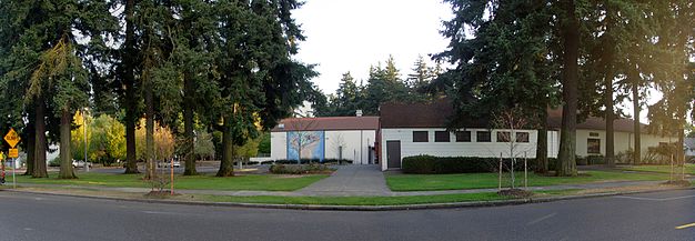
Mt. Scott-Arleta neighborhood life is centered on Mt. Scott Park and the Mt. Scott Community Center within it. First constructed in 1927 as a wood-frame bathhouse for a pre-existing outdoor pool, the Community Center now houses an aquatic center added in 2000. [4]

Related Research Articles

<span class="mw-page-title-main">Hawthorne, Portland, Oregon</span> Area of Portland, Oregon, U.S.

Hawthorne is located at 43°27'22"N 123°4'51"W.

<span class="mw-page-title-main">Mount Tabor, Portland, Oregon</span> Neighborhood in Portland, Oregon, United States

Mount Tabor is the name of a volcanic cinder cone, the city park on the volcano, and the neighborhood of Southeast Portland that surrounds it, all in the U.S. state of Oregon. The name refers to Mount Tabor, Israel. It was named by Plympton Kelly, son of Oregon City pioneer resident Clinton Kelly.

<span class="mw-page-title-main">Woodstock, Portland, Oregon</span> Neighborhood in Portland, Oregon, United States

Woodstock is a neighborhood located in inner southeast Portland, Oregon, United States.

<span class="mw-page-title-main">Ardenwald-Johnson Creek, Portland, Oregon</span> Unincorporated community in the state of Oregon, United States

Ardenwald-Johnson Creek is a neighborhood straddling the border between Portland and Milwaukie, Oregon. It is recognized by both Portland's Office of Neighborhood Involvement as well as Milwaukie's Neighborhoods Program.

<span class="mw-page-title-main">Neighborhoods of Portland, Oregon</span> 95 sections of the large Pacific Northwest city

Portland, Oregon is divided into six sections: North Portland, Northeast Portland, Northwest Portland, South Portland, Southeast Portland, and Southwest Portland. There are 95 officially recognized neighborhoods, each of which is represented by a volunteer-based neighborhood association. No neighborhood associations overlap the Willamette River, but a few overlap the addressing sextants. For example, most addresses in the South Portland Neighborhood Association are South, but a portion of the neighborhood is west of SW View Point Terrace where addresses have a SW prefix. Similarly the Buckman Neighborhood Association spans both NE and SE Portland.

<span class="mw-page-title-main">Lents, Portland, Oregon</span> Neighborhood in Portland, Oregon, United States

The Lents neighborhood in the Southeast section of Portland, Oregon is bordered by SE Powell Blvd. on the north, the Clackamas County line or City of Portland line on the south, SE 82nd Ave. to the west, and roughly SE 112th on the east. The NE corner overlaps with the Powellhurst-Gilbert neighborhood. In addition to Powellhurst-Gilbert on the north and east, Lents also borders Foster-Powell, Mt. Scott-Arleta, and Brentwood-Darlington on the west and Pleasant Valley on the east.

<span class="mw-page-title-main">Creston-Kenilworth, Portland, Oregon</span> Neighborhood in Portland, Oregon, United States

Creston-Kenilworth is a neighborhood in the Southeast section of Portland, Oregon, lying between SE 26th Ave. on the west and SE Foster Rd. on the east, and between SE Powell Blvd. on the north and SE Holgate Blvd. on the south. It is adjacent to the neighborhoods of Brooklyn to the west, Hosford-Abernethy, and Richmond to the north, Foster-Powell and Mt. Scott-Arleta to the east, and Reed and Woodstock to the south.

<span class="mw-page-title-main">Foster-Powell, Portland, Oregon</span> Neighborhood in Portland, Oregon, United States

Foster-Powell is a neighborhood in the Southeast section of Portland, Oregon. The triangular neighborhood is bounded by three major transit arteries: Powell Boulevard to the north, Foster Road to the south, and 82nd Avenue to the east.

South Tabor is a neighborhood in southeastern Portland, Oregon in the United States. The neighborhood is bounded by SE Division, Powell, 52nd, and 82nd Avenues. Its neighborhood association is a member of the Southeast Uplift coalition, which serves as its link to Portland's Office of Neighborhood Involvement.

Montavilla is a neighborhood in the Northeast and Southeast sections of Portland, Oregon, United States, and contains an area east of Mount Tabor and west of Interstate 205, from the Banfield to SE Division. It is bordered by North Tabor, Mount Tabor, Madison South, Hazelwood, and Powellhurst-Gilbert.

<span class="mw-page-title-main">Woodstock Community Center</span> Community center and former fire station in Portland, Oregon, U.S.

The Woodstock Community Center is a community center and former fire station built in 1928, located in the Woodstock neighborhood of Portland, Oregon, United States. The building was converted to a community center when Portland Parks & Recreation acquired ownership in 1958. In 2003, community members prevented closure due to budget constraints by forming a group called Friends of the Woodstock Community Center to raise funds and coordinate volunteers.

<span class="mw-page-title-main">Burnside Street</span> Street in Portland, Oregon, U.S.

Burnside Street is a major thoroughfare of Portland, in the U.S. state of Oregon, and one of a few east–west streets that runs uninterrupted on both sides of the Willamette River. It serves as the dividing line between North Portland and South Portland. Its namesake bridge, Burnside Bridge, is one of the most heavily traversed in Portland. In Gresham between approximately the east 18300 block to Mt. Hood Hwy, Burnside runs southeast–northwest and is no longer the divide between northeast and southeast on the City of Portland-Multnomah County street grid. Additionally, SE Burnside St becomes NW Burnside Road at SE 202nd/NW Birdsdale Ave, and NE Burnside Rd at N Main Ave in Gresham. Burnside Road's eastern terminus is where it meets Mt. Hood Hwy (US-26), E Powell Blvd (US-26), and SE Powell Valley Road.

<span class="mw-page-title-main">82nd Avenue</span> Street in Portland, Oregon

82nd Avenue of the Roses is a street in Portland, Oregon, and comprises the northern end of Oregon Route 213, also known as the Cascade Highway. It is one of the longest streets in Portland, running down the entire east side of the city, and extending into suburbs to the south.

<span class="mw-page-title-main">Southeast Bybee Boulevard station</span> MAX Orange Line station in Portland, Oregon, U.S.

Southeast Bybee Boulevard is a light rail station in Portland, Oregon, United States, served by TriMet as part of the MAX Light Rail system. It is the 14th station southbound on the Orange Line, which operates between Portland City Center, Southeast Portland, and Milwaukie. The grade-separated, island platform station adjoins Union Pacific Railroad (UP) freight tracks to the east and McLoughlin Boulevard to the west. Its entrances are located on the Bybee Bridge, which spans over the platform and connects Portland's Sellwood-Moreland and Eastmoreland neighborhoods. Nearby places of interest include Westmoreland Park, Eastmoreland Golf Course, Crystal Springs Rhododendron Garden, and Reed College.

Charles B. Walker Stadium at Lents Park is a baseball stadium located in Lents Park in the Lents neighborhood of Portland, Oregon. It has been home to the West Coast League Portland Pickles baseball team since 2016. The Pickles play thirty home games per sixty game season. The team pays rent to the City, cleans the stadium, and provides security during games. Outside of the dates set aside for the team, the stadium is open for permitted play by anyone who reserves it. The Northwest Independent Baseball League plays many of its games at Walker Stadium.

<span class="mw-page-title-main">Mt. Scott Park</span> Public park in Portland, Oregon, U.S.

Mt. Scott Park is an 11.22-acre (4.54 ha) public park in Portland, Oregon's Mt. Scott-Arleta neighborhood, in the United States. Named after Harvey W. Scott, the park was acquired in 1922 and houses the Mt. Scott Community Center.

<span class="mw-page-title-main">Hawthorne Boulevard (Portland, Oregon)</span>

Hawthorne Boulevard is an east–west street in Portland, Oregon and the dividing line between multiple neighborhoods, although "Hawthorne" is often itself considered its own neighborhood. The street stretches from the Willamette River on the west,, and 92nd Avenue on the east. Mount Tabor blocks the street between 60th Street and 72nd Avenue. Hawthorne Boulevard is a principal street west of 50th Avenue and a residential street to the east. The most famous portion of Hawthorne Boulevard is between 29th Avenue and Cesar Chavez Boulevard which serves as a cultural hot spot for Portland's hippie movement. This section of the street is filled with local businesses, boutiques, restaurants, and gift stores, as well as the first Fred Meyer grocery at 36th and Hawthorne, and a bakery at 12th and Hawthorne. It the grocery closed in the 1930s. Hawthorne Boulevard is often compared to Haight Street in San Francisco due to the similar culture of both streets. The street is named for Doctor James C. Hawthorne, a politician and physician. Dr. Hawthorne donated land for the Oregon Hospital for the Insane near the modern day Colonel Summers Park in 1862. The Hospital for the Insane is often called the Hawthorne Asylum, and the street, originally named U Street, took on the moniker Asylum Avenue. The Asylum closed in 1883, and an ordinance was passed to rename the street to Hawthorne Avenue in 1888.

<span class="mw-page-title-main">Arleta Triangle</span> Pocket park in Portland, Oregon, U.S.

Arleta Triangle is a traffic island and pocket park in Portland, Oregon's Mt. Scott-Arleta neighborhood, in the United States. Rebecca Ellis of Oregon Public Broadcasting has described the space as a "formerly shopping-cart littered traffic island turned pocket park".

<span class="mw-page-title-main">Portland Mercado</span> Food cart pod in Portland, Oregon, U.S.

Portland Mercado is a collection of food carts in Portland, Oregon, United States. The carts are located in Southeast Portland's Mt. Scott-Arleta neighborhood, at the border of Foster-Powell.

<span class="mw-page-title-main">Arleta Library Bakery & Cafe</span> Defunct restaurant in Portland, Oregon, U.S.

The Arleta Library Bakery & Cafe was a restaurant in Portland, Oregon, in the United States. The business operated in southeast Portland's Mt. Scott-Arleta neighborhood for approximately fifteen years; Arleta was established by owners Sarah and Nick Iannarone in 2005 and closed in 2020, during the COVID-19 pandemic. Guy Fieri had visited the restaurant for an episode of the Food Network's Diners, Drive-Ins and Dives.

References

  1. 1 2 "Mt. Scott-Arleta". PortlandMaps. City of Portland. Retrieved April 6, 2023.
  2. 1 2 "Mt. Scott-Arleta Neighborhood Plan". City of Portland, Bureau of Planning. March 1996. Retrieved September 14, 2012.
  3. Survey and Assessor Image Locator (Internet Explorer required). "Mutnomah County SAIL". Multnomah County. Archived from the original on January 30, 2013. Retrieved September 14, 2012.
  4. "Find a Park | The City of Portland, Oregon". www.portlandoregon.gov. Retrieved 2020-06-01.