Lents, Portland, Oregon

Last updated

Lents
Neighborhood
Lents Town Center 2021.jpg
Lents Town Center at night, April 2021
Lents, Portland, Oregon
Location in Portland
Coordinates: 45°28′31″N122°33′43″W / 45.47540°N 122.56207°W / 45.47540; -122.56207 PDF map
Country United States
State Oregon
City Portland
Government
  AssociationLents Neighborhood Association
  Coalition East Portland Neighborhood Office
Area
  Total3.03 sq mi (7.86 km2)
Population
 (2010) [1]
  Total20,156
  Density6,600/sq mi (2,600/km2)
Housing
[1]
  No. of households7169
  Occupancy rate93% occupied
  Owner-occupied3192 households (55%)
  Renting2564 households (45%)
  Avg. household size2.81 persons

The Lents neighborhood in the Southeast section of Portland, Oregon is bordered by SE Powell Blvd. on the north, the Clackamas County line or City of Portland line on the south (whichever is farther south), SE 82nd Ave. to the west, and roughly SE 112th on the east. The NE corner overlaps with the Powellhurst-Gilbert neighborhood. In addition to Powellhurst-Gilbert on the north and east, Lents also borders Foster-Powell, Mt. Scott-Arleta, and Brentwood-Darlington on the west and Pleasant Valley on the east.

Contents

The neighborhood is one of the larger in the city at 3.75 square miles (9.7 km2) and one of its oldest. Since the late 20th century, it has become more diverse, the home of many Asian, Russian/Eastern European, and Latino immigrants. [2]

Lents is six miles (10 km) southeast of downtown Portland and lies within the 97266 ZIP code.

History

Lents was originally platted as the Town of Lent by Oliver P. Lent (1830–1899) in 1892. The original town was bounded by SE Foster Rd., SE Duke St., SE 92nd Ave, and SE 97th Ave. Lent came to Oregon from Ohio. [3]

Lent's town was originally built as a self-sufficient town and suburb of Portland. In 1912, when Lents had a population nearing 10,000, the city of Portland annexed the suburb. [4] Because of its distance from central Portland and lower income residents, the neighborhood suffered delays in getting street and sewer improvements. [4] Interstate 205 was originally planned to follow 39th Avenue, but the powerful and wealthier residents of Portland's Laurelhurst neighborhood successfully lobbied to have the path changed to 52nd Avenue. By the time it came to final planning in the 1970s, the city had grown and decided to move the freeway's path further out to 96th Avenue, effectively cutting the Lents neighborhood in half. [5] By contrast, Maywood Park incorporated as an independent city and sued to stop construction of the freeway; it reached a compromise with the city over the route. [6]

Demographics

As of the 2010 Census, Lents had a population of 20,156. Its residents identified as 60.1 percent white, 14.1 percent Asian, 4.5 percent black, and 1.0 percent Native American, with 3.7 percent of census respondents identifying as two or more races. 15.8 percent of census respondents identified as Hispanic or Latino.

Transportation

MAX Green Line going through the Lents Town Center Fosterblvd.jpg
MAX Green Line going through the Lents Town Center

Lents is a transportation hub for the Portland region. Interstate 205 and three of Portland's important arterials—Powell Boulevard, Foster Road and 82nd Avenue—pass through the neighborhood, as well as the MAX Green Line and the Springwater Corridor pedestrian and bike trail.

I-205 freeway cuts through the center of the original town, where SE 92nd Avenue, which was only a half mile east of 82nd avenue, the original road to Oregon City, met SE Foster Road, which led to Foster's Farm. Beginning in 1892, a streetcar ran from downtown Portland. The route traveled from downtown across the Hawthorne Bridge to SE 50th Avenue. At SE 50th, an extant curve in the road shows the route going south. SE 50th Avenue runs into SE Foster Road. The trolley continued on SE Foster to SE 72nd Avenue, bearing south. Another extant curve to the left at Gray's Corner sent the trolley east on SE Woodstock Boulevard. This road was followed through to the curve at 97th which sent it into the neighborhood south of SE Foster Road. After several more blocks, the line ended at SE 100th Avenue where it met the interurban line that once occupied what is now called the Springwater Corridor. The interurban line continued to points east, ending in Estacada.

Lents Town Center MAX Station along the Green Line Green Line train at Lents Town Center station, June 2010.jpg
Lents Town Center MAX Station along the Green Line

Lents is served by the following TriMet bus lines:

Future

In recent years, Portland has seen the potential value of the Lents neighborhood and established it as an Urban Renewal Area, which allows the city to bond on future increases in property tax revenues to fund capital projects throughout the Lents Town Center Urban Renewal Area. Many new homes and businesses have been established and more are planned. The MAX light rail system has been expanded southward from the Gateway hub, along I-205 to the Clackamas Town Center.

Lentspanorama.jpg
Panorama of Lents in 2010. In the late 2010s, hundreds of affordable and market-rate apartments opened in the area.

Urban Renewal Area

Storefronts on 92nd Avenue before renovations through public subsidy PotentialPDCstorefrontprogram.jpg
Storefronts on 92nd Avenue before renovations through public subsidy
The Lents Town Center on 92nd Avenue towards Foster Road in 2010 Lentstowncenter.jpg
The Lents Town Center on 92nd Avenue towards Foster Road in 2010

With the completion of the Outer Southeast Community Plan, the Lents Neighborhood Plan, and the Lents Revitalization Plan, community stakeholders worked together to craft short and long-term objectives for public and private partners to guide an ambitious and comprehensive neighborhood development agenda. As a designated "Town Center," the future of Lents is also an important component of the Metro 2040 Framework Plan. [7]

In September 1998, the City Council established a Lents Town Center Urban Renewal Area (LTCURA) in order to accomplish community goals. These include generation of new family wage jobs, assistance to new and existing business, improvements to local infrastructure such as streets and parks, new housing construction and improvements to existing housing. Implementation of the plan began in fiscal year 1999–2000.

On May 8, 2007, PDC staff presented an overview of the plan amendment study process to the Lents Town Center Urban Renewal Advisory Committee (URAC and requested their project ideas for consideration, concerns, and feedback.

Moving forward, the Lents Town Center Plan Amendment Study revisited the existing urban renewal boundary (2,472 acres) and explored an increase in maximum indebtedness to fund community development projects. The study area for the expansion included three areas centered along major transportation corridors: Foster Road, Powell Boulevard, and 122nd Avenue.

On May 14, 2008, the PDC Board unanimously approved the Lents Town Center Resolution. On Wednesday, June 25, 2008, the City Council approved the following amendments with a 4–0 vote. The First Amendment to the Lents Town Center Urban Renewal Area will expand boundaries by 140.05 acres (0.5668 km2), increase maximum indebtedness by $170 million and extend the expiration date to June 30, 2020.

The PDC is working in Lents to: [8]

Notable residents

Parks

Related Research Articles

<span class="mw-page-title-main">Interstate 205 (Oregon–Washington)</span> Interstate Highway in Oregon and Washington

Interstate 205 (I-205) is an auxiliary Interstate Highway in the Portland metropolitan area of Oregon and Washington, United States. The north–south freeway serves as a bypass route of I-5 along the east side of Portland, Oregon, and Vancouver, Washington. It intersects several major highways and serves Portland International Airport.

<span class="mw-page-title-main">MAX Yellow Line</span> Light rail line in Portland, Oregon

The MAX Yellow Line is a light rail service in Portland, Oregon, United States, operated by TriMet as part of the MAX Light Rail system. It connects North Portland to Portland City Center and Portland State University (PSU) with 17 stops from Expo Center station to PSU South/Southwest 6th and College station. The line travels from Portland Expo Center in the north, south to the Rose Quarter through a 5.8-mile (9.3 km) light rail segment along the median of Interstate Avenue. From the Rose Quarter, it crosses the Willamette River via the Steel Bridge and enters downtown Portland, where it operates as a northbound-only service of the Portland Transit Mall on 6th Avenue. Service runs for approximately 21 hours daily with a headway of 15 minutes during most of the day.

The Mount Hood Freeway is a partially constructed but never to be completed freeway alignment of U.S. Route 26 and Interstate 80N, which would have run through southeast Portland, Oregon. Related projects would have continued the route through the neighboring suburb of Gresham, out to the city of Sandy.

<span class="mw-page-title-main">I-205 busway</span> Abandoned transit project in Portland, Oregon, now used for light rail

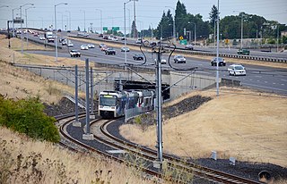
The I-205 busway was a partially built busway along the right-of-way of the Interstate 205 freeway in Portland, Oregon. Although it never opened as a busway, its right-of-way has been in use by light rail lines partially since 2001 and fully since 2009.

<span class="mw-page-title-main">Ardenwald-Johnson Creek, Portland, Oregon</span> Unincorporated community in the state of Oregon, United States

Ardenwald-Johnson Creek is a neighborhood straddling the border between Portland and Milwaukie, Oregon. It is recognized by both Portland's Office of Neighborhood Involvement as well as Milwaukie's Neighborhoods Program.

Brentwood-Darlington is a neighborhood on the southern edge of Portland, Oregon, bordering SE 45th Avenue to the west, SE Duke Street to the north, and SE 82nd Avenue to the east. The county line separating Multnomah County from Clackamas County forms most of the neighborhood's southern boundary, though small portions of the neighborhood and the city extend into Clackamas County. Roughly, the southern boundary is SE Harney Drive on the eastern one-fourth, and SE Clatsop Street on the other three-quarters.

<span class="mw-page-title-main">Mt. Scott-Arleta, Portland, Oregon</span> Neighborhood in Portland, Oregon, U.S.

The Mt. Scott-Arleta neighborhood of Portland, Oregon is located in the city's southeast quadrant. It is bounded on the north by SE Foster Road, west by SE 60th Avenue, east by SE 82nd Avenue, and south by SE Duke. Mt. Scott-Arleta borders the neighborhoods of Woodstock on the west, Foster-Powell on the north, Lents on the east, and Brentwood-Darlington on the south.

<span class="mw-page-title-main">Foster-Powell, Portland, Oregon</span> Neighborhood in Portland, Oregon, United States

Foster-Powell is a neighborhood in the Southeast section of Portland, Oregon. The triangular neighborhood is bounded by three major transit arteries: Powell Boulevard to the north, Foster Road to the south, and 82nd Avenue to the east.

South Tabor is a neighborhood in southeastern Portland, Oregon in the United States. The neighborhood is bounded by SE Division, Powell, 52nd, and 82nd Avenues. Its neighborhood association is a member of the Southeast Uplift coalition, which serves as its link to Portland's Office of Neighborhood Involvement.

Montavilla is a neighborhood in the Northeast and Southeast sections of Portland, Oregon, United States, and contains an area east of Mount Tabor and west of Interstate 205, from the Banfield to SE Division. It is bordered by North Tabor, Mount Tabor, South Tabor, Madison South, Hazelwood, and Powellhurst-Gilbert.

<span class="mw-page-title-main">Johnson Creek (Willamette River tributary)</span> Creek in Oregon, USA

Johnson Creek is a 25-mile (40 km) tributary of the Willamette River in the Portland metropolitan area of the U.S. state of Oregon. Part of the drainage basin of the Columbia River, its catchment consists of 54 square miles (140 km2) of mostly urban land occupied by about 180,000 people as of 2012. Passing through the cities of Gresham, Portland, and Milwaukie, the creek flows generally west from the foothills of the Cascade Range through sediments deposited by glacial floods on a substrate of basalt. Though polluted, it is free-flowing along its main stem and provides habitat for salmon and other migrating fish.

<span class="mw-page-title-main">Springwater Corridor</span> Bicycle and pedestrian trail in the Portland, Oregon metropolitan area

The Springwater Corridor Trail is a bicycle and pedestrian rail trail in the Portland metropolitan area in Oregon, United States. It follows a former railway line from Boring through Gresham to Portland, where it ends south of the Eastbank Esplanade. Most of the corridor, about 21 miles (34 km) long, consists of paved, off-street trail, though about 1 mile (1.6 km) overlaps city streets in Portland's Sellwood neighborhood. A large segment roughly follows the course of Johnson Creek and crosses it on bridges many times. Much of the corridor was acquired by the City of Portland in 1990; remaining segments were acquired by Metro thereafter.

<span class="mw-page-title-main">40-Mile Loop</span> Multi-use trail in Portland, Oregon, United States

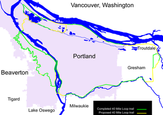
The 40-Mile Loop is a partially completed greenway trail around and through Portland in the U.S. state of Oregon. It was proposed in 1903 by the Olmsted Brothers architecture firm as part of the development of Forest Park. One greenway expert calls it "one of the most creative and resourceful greenway projects in the country."

<span class="mw-page-title-main">Lents Town Center/Southeast Foster Road station</span>

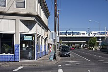
Lents Town Center/Southeast Foster Road is a light rail station on the MAX Green Line in Portland, Oregon. It is the 5th stop southbound on the I-205 MAX branch. The station is at the intersection of Interstate 205 and Foster Road. It is located in the Lents neighborhood's town center business district. It also provides access to the Springwater Corridor, which was once a transit line to the suburbs and is now a dedicated bikeway through southeast Portland.

<span class="mw-page-title-main">Southeast Fuller Road station</span>

Southeast Fuller Road is a light rail station on TriMet's MAX Green Line in Portland, Oregon, located between SE 82nd Avenue and Interstate 205. It is the 7th stop southbound on the Interstate 205 MAX branch. The station has a center platform and is surrounded by a park and ride facility.

<span class="mw-page-title-main">Fubonn Shopping Center</span> Shopping mall in Oregon, U.S.

The Fubonn Shopping Center is an enclosed shopping mall in the Powellhurst-Gilbert neighborhood of Portland, Oregon, in the United States. The mall claims to be the largest Asian mall in Oregon and lists 29 stores as tenants in November 2011. The mall is located at SE 82nd Avenue and SE Woodward Street. It is anchored by the Fubonn Supermarket, a large Asian grocery and housewares store. The Oregonian calls it "the eastside's answer to Uwajimaya".

<span class="mw-page-title-main">82nd Avenue</span> Street in Portland, Oregon

82nd Avenue of the Roses is a street in Portland, Oregon, and comprises the northern end of Oregon Route 213, also known as the Cascade Highway. It is one of the longest streets in Portland, running down the entire east side of the city, and extending into suburbs to the south.

Charles B. Walker Stadium at Lents Park is a baseball stadium located in Lents Park in the Lents neighborhood of Portland, Oregon. It has been home to the West Coast League Portland Pickles baseball team since 2016. The Pickles play thirty home games per sixty game season. The team pays rent to the City, cleans the stadium, and provides security during games. Outside of the dates set aside for the team, the stadium is open for permitted play by anyone who reserves it. The Northwest Independent Baseball League plays many of its games at Walker Stadium.

<span class="mw-page-title-main">Jade District</span> Commercial area in Portland, Oregon, U.S.

The Jade District is an Asian-dominated commercial area and cultural hub radiating outward from Southeast 82nd Avenue and Division Street, in Portland, Oregon, in the United States. It is roughly between Division Street and Powell Boulevard to the north and south, and between SE 75th Avenue and I-205 to the east and west. Part of the Montavilla, Powellhurst-Gilbert, and South Tabor neighborhoods, the district is one of the most diverse census tracts in the state of Oregon.

<span class="mw-page-title-main">Lombard Street (Portland, Oregon)</span>

Lombard Street is a main thoroughfare in Portland, Oregon, United States. It serves as a boundary and main commercial street for several north Portland neighborhoods.

References

  1. 1 2 Demographics (2010)
  2. Sadowsky, Dan (May 10, 2004). "Lents market bets future on immigrant farmers". Portland Business Journal. Archived from the original on September 29, 2007. Retrieved September 6, 2006.
  3. Freedman, Marc (August 4, 2008). Prime Time: How Baby Boomers Will Revolutionize Retirement And Transform America. PublicAffairs. ISBN   978-0-7867-2418-5.
  4. 1 2 MacColl, E. Kimbark (1979). The Growth of a City: Power and Politics in Portland, Oregon 1915–1950. Portland, Oregon: The Georgian Press. ISBN   0-9603408-1-5.
  5. McCarthy, Dennis (February 24, 1975). "I-205 News Good, Bad". The Oregon Journal. p. A11.
  6. Ford, Sue (September 27, 1977). "Maywood Park had strong voice in designing I-205 in town". The Oregonian. p. E9.
  7. Metro 2040 Framework Plan
  8. "Projects: Lents : Portland Development Commission". Archived from the original on August 6, 2003. Retrieved July 24, 2010.
  9. "Singer Woody Guthrie's rented flat in Lents is for sale; his Portland legacy remains". oregonlive. January 5, 2023. Retrieved August 14, 2023.