
East 122nd Avenue station is a MAX light rail station in Portland, Oregon. It serves the Blue Line and is currently the 16th stop eastbound on the Eastside MAX branch. The MAX system is owned and operated by TriMet, the major transit agency for the Portland metropolitan area.

The MAX Yellow Line is a light rail line serving Portland, Oregon, United States. Operated by TriMet as part of the MAX Light Rail system, it connects North Portland, Portland City Center, and Portland State University (PSU). The line serves 17 stations; it runs north–south from Expo Center station to PSU South/Southwest 6th and College station, interlining with the Green and Orange lines within the Portland Transit Mall. Service runs for 21 hours per day with headways of up to 15 minutes. The Yellow Line is the fourth-busiest service in the MAX system; it carried an average 12,960 riders per weekday in September 2019.
Northeast 7th Avenue is a light rail station on the Blue, Green and Red Lines in Portland, Oregon. It is the 9th stop eastbound on the Eastside MAX.

Mall/Southwest 4th Avenue and Mall/Southwest 5th Avenue were a pair of light rail stations in Portland, Oregon, United States, served by TriMet as part of the MAX Light Rail system. Built into the sidewalk at Southwest Yamhill and Morrison streets between 4th and 5th avenues in downtown Portland, the Mall stations were served by the Blue and Red lines upon closing. They had also been served by the Yellow Line from May 2004 to August 2009.

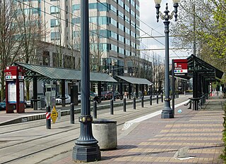
Like transportation in the rest of the United States, the primary mode of local transportation in Portland, Oregon is the automobile. Metro, the metropolitan area's regional government, has a regional master plan in which transit-oriented development plays a major role. This approach, part of the new urbanism, promotes mixed-use and high-density development around light rail stops and transit centers, and the investment of the metropolitan area's share of federal tax dollars into multiple modes of transportation. In the United States, this focus is atypical in an era when automobile use led many areas to neglect their core cities in favor of development along interstate highways, in suburbs, and satellite cities.
Portland is "an international pioneer in transit orientated developments."

Washington/Southeast 12th Avenue is a light rail station on the MAX Blue Line in Hillsboro, Oregon. Hillsboro's West Precinct is near the station. Opened in 1998, it is the 17th stop westbound on the Westside MAX, and the last eastbound stop prior to crossing the Main Street Bridge. This is the last stop westbound to be on a grade-separated right-of-way. One block west of here, trains enter the median of Washington Avenue to run through downtown Hillsboro.
The MAX Orange Line is a light rail line serving the Portland metropolitan area in the U.S. state of Oregon. Operated by TriMet as part of the MAX Light Rail system, it connects Portland City Center, Portland State University (PSU), Southeast Portland, Milwaukie, and Oak Grove. The line serves 17 stations and runs for 201⁄2 hours per day with headways of up to 15 minutes. It averaged 3,480 daily weekday riders in September 2020.

Ardenwald-Johnson Creek is a neighborhood straddling the border between Portland and Milwaukie, Oregon. It is recognized by both Portland's Office of Neighborhood Involvement as well as Milwaukie's Neighborhoods Program.
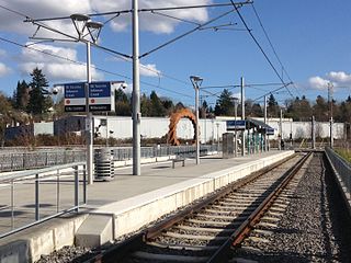
Southeast Tacoma/Johnson Creek is a light rail station and park and ride for the MAX Orange Line. Service began on September 12, 2015. It is the third stop northbound on the Orange Line. The station was built for residents of the Sellwood and Ardenwald neighborhoods of Portland and Milwaukie. The station is located adjacent to Oregon Route 99E and can be directly accessed by northbound traffic and by traffic from the portion of SE Tenino Street that connects SE Tacoma to SE Johnson Creek Boulevard.

Southeast Bybee Boulevard is a light rail station in Portland, Oregon, United States, served by TriMet as part of the MAX Light Rail system. It is the 14th station southbound on the Orange Line, which operates between Portland City Center, Southeast Portland, and Milwaukie. The grade-separated, island platform station adjoins Union Pacific Railroad (UP) freight tracks to the east and McLoughlin Boulevard to the west. Its entrances are located on the Bybee Bridge, which spans over the platform and connects Portland's Sellwood-Moreland and Eastmoreland neighborhoods. Nearby places of interest include Westmoreland Park, Eastmoreland Golf Course, Crystal Springs Rhododendron Garden, and Reed College.

Southeast Park Avenue is a light rail station on the MAX Orange Line located at Southeast McLoughlin Boulevard and Park Avenue in Oak Grove, an unincorporated area neighboring Milwaukie in Clackamas County, Oregon, in the United States. It is the terminus and southernmost stop on the Orange Line and has a 401-space park and ride facility.

Milwaukie/Main Street is a MAX Orange Line station located in downtown Milwaukie, Oregon. It is the second northbound station on the Orange Line, preceded by the terminus at SE Park Ave. The station is located along Union Pacific Railroad right-of-way on a site bounded by Lake Road, SE 21st Avenue, and Adams Street near the city's post office. Amenities at the station including bike parking and connections to TriMet bus routes 29, 32, 33, and 34; it also has no parking spaces for cars.

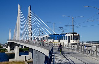
South Waterfront/South Moody, formerly South Waterfront/Southwest Moody, is a combined light rail and bus station located at 698 Southwest Porter Street in the South Waterfront neighborhood of Portland, Oregon, at the west end of the Tilikum Crossing bridge. It is serviced by the MAX Orange Line and TriMet buses. Portland Streetcar travels through it but does not service it.

OMSI/Southeast Water station is a light rail station on the MAX Orange Line, located at 2210 Southeast 2nd Place on the east foot of the Tilikum Crossing bridge in Portland, Oregon. Like South Waterfront/SW Moody Station on the west side of the Willamette River, it consists of two island platforms. MAX trains stop on the outside of the platforms, while TriMet buses stop on the inner lanes. Just northwest of the platforms is a Portland Streetcar stop served by the A and B Loop lines. The station is named after the nearby Oregon Museum of Science and Industry.

Southeast 17th Avenue and Rhine Street is a MAX Orange Line station located at 3424 Southeast 17th Avenue in Portland, Oregon's Brooklyn neighborhood, in the United States. Along These Lines is installed at the station.

Southeast 17th Avenue and Holgate Boulevard is a MAX Orange Line station located in the median of Southeast 17th Avenue at Holgate Boulevard in the Brooklyn neighborhood of Portland, Oregon.

Tri It is an outdoor 2015 mural by Blaine Fontana, painted outside the TriMet Bus Maintenance Facility in Portland, Oregon, in the United States.

Kerf is an outdoor series of two pigmented cast concrete sculptures by Thomas Sayre, installed at the MAX Orange Line's Southeast Tacoma/Johnson Creek station in the southeast Portland, Oregon portion of the Ardenwald-Johnson Creek neighborhood, which straddles the border between Portland and Milwaukie, Oregon.
Velosaurus is an outdoor 2015 concrete and painted steel sculpture by Horatio Law, installed beneath the Powell Blvd. Light Rail Overpass between the MAX Orange Line's Clinton St/SE 12th Ave and Clinton St/SE 12th Ave stations in southeast Portland, Oregon, in the United States. The piece is a series of eight bas-relief panels made of recycled bicycle and skateboard parts, arranged to appear like dinosaur skeletal remains.

