
The Willamette River is a major tributary of the Columbia River, accounting for 12 to 15 percent of the Columbia's flow. The Willamette's main stem is 187 miles (301 km) long, lying entirely in northwestern Oregon in the United States. Flowing northward between the Oregon Coast Range and the Cascade Range, the river and its tributaries form the Willamette Valley, a basin that contains two-thirds of Oregon's population, including the state capital, Salem, and the state's largest city, Portland, which surrounds the Willamette's mouth at the Columbia.

The Tualatin River is a tributary of the Willamette River in Oregon in the United States. The river is about 83 miles (134 km) long, and it drains a fertile farming region called the Tualatin Valley southwest and west of Portland at the northwest corner of the Willamette Valley. There are approximately 500,000 people residing on 15 percent of the land in the river's watershed.

The Tualatin Valley is a farming and suburban region southwest of Portland, Oregon. The valley is formed by the meandering Tualatin River, a tributary of the Willamette River at the northwest corner of the Willamette Valley, east of the Northern Oregon Coast Range. Most of the valley is located within Washington County, separated from Portland by the Tualatin Mountains. Communities in the Tualatin Valley include Banks, Forest Grove, Cornelius, Hillsboro, Aloha, Beaverton, Sherwood, Tigard, and Tualatin.

Forest Park is a public municipal park in the Tualatin Mountains west of downtown Portland, Oregon, United States. Stretching for more than 8 miles (13 km) on hillsides overlooking the Willamette River, it is one of the country's largest urban forest reserves. The park, a major component of a regional system of parks and trails, covers more than 5,100 acres (2,064 ha) of mostly second-growth forest with a few patches of old growth. About 70 miles (110 km) of recreational trails, including the Wildwood Trail segment of the city's 40-Mile Loop system, crisscross the park.

The Boring Lava Field is a Plio-Pleistocene volcanic field with cinder cones, small shield volcanoes, and lava flows in the northern Willamette Valley of the U.S. state of Oregon and adjacent southwest Washington. The field got its name from the town of Boring, Oregon, located 12 miles (20 km) southeast of downtown Portland. Boring lies southeast of the densest cluster of lava vents. The zone became volcanically active about 2.7 million years ago, with long periods of eruptive activity interspersed with quiescence. Its last eruptions took place about 57,000 years ago at the Beacon Rock cinder cone volcano; the individual volcanic vents of the field are considered extinct, but the field itself is not.

The Bull Run River is a 21.9-mile (35.2 km) tributary of the Sandy River in the U.S. state of Oregon. Beginning at the lower end of Bull Run Lake in the Cascade Range, it flows generally west through the Bull Run Watershed Management Unit (BRWMU), a restricted area meant to protect the river and its tributaries from contamination. The river, impounded by two artificial storage reservoirs as well as the lake, is the primary source of drinking water for the city of Portland, Oregon.

Larch Mountain is an extinct volcano near Portland, Oregon. The name is misleading, as no western larch can be found there. It received that name when early lumbermen sold the noble fir wood as larch. The peak can be reached between May and November on paved Larch Mountain Road, 16 mi (26 km) east of Corbett, Oregon, although the road is closed during the winter and spring months. The road leading to Larch Mountain from the Historic Columbia River Highway is 14 miles long, which closed at milepost 10 from Nov. through late May or early June due to snow.

Rocky Butte is an extinct cinder cone butte in Portland, Oregon, United States. It is also part of the Boring Lava Field, a group of volcanic vents and lava flows throughout Oregon and Washington state. The volcano erupted between 285,000 and 500,000 years ago.
Goose Hollow is a neighborhood in southwest Portland, Oregon, United States. It acquired its distinctive name through early residents' practice of letting their geese run free in Tanner Creek Gulch and near the wooded ravine in the Tualatin Mountains known as the Tanner Creek Canyon. Tanner Creek Gulch was a 20-block-long, 50-foot-deep (15 m) gulch that started around SW 17th and Jefferson and carried the waters of Tanner Creek into Couch Lake. Over a century ago, Tanner Creek was buried 50 feet (15 m) underground, and the Tanner Creek Gulch was infilled. Thus, the only remaining part of the hollow is the ravine carved out by Tanner Creek through which The Sunset Highway carrying US-26 passes and which the Vista Bridge spans.
Southwest Hills is a neighborhood in the West Hills in the southwest section of Portland, Oregon, United States. The northeastern part of the neighborhood, above Goose Hollow and Downtown Portland, is known as Portland Heights. Much of the western portion of the neighborhood lies outside the Portland city limits, in unincorporated Multnomah County.

The Northern Oregon Coast Range is the northern section of the Oregon Coast Range, in the Pacific Coast Ranges physiographic region, located in the northwest portion of the state of Oregon, United States. This section of the mountain range, part of the Pacific Coast Ranges, contains peaks as high as 3,710 feet (1,131 m) for Rogers Peak. Forests in these mountains are considered to be some of the most productive timber land in the world. The Central Oregon Coast Range is directly south of this section with the Southern Oregon Coast Range beyond the central range.
Tryon Creek is a 4.85-mile (7.81 km) tributary of the Willamette River in the U.S. state of Oregon. Part of the drainage basin of the Columbia River, its watershed covers about 6.5 square miles (16.8 km2) in Multnomah and Clackamas counties. The stream flows southeast from the Tualatin Mountains through the Multnomah Village neighborhood of Portland and the Tryon Creek State Natural Area to the Willamette in the city of Lake Oswego. Parks and open spaces cover about 21 percent of the watershed, while single-family homes dominate most of the remainder. The largest of the parks is the state natural area, which straddles the border between the two cities and counties.

The Robertson Tunnel is a twin-bore light rail tunnel through the Tualatin Mountains west of Portland, Oregon, United States, used by the MAX Blue and Red Lines. The tunnel is 2.9 miles long and consists of twin 21-foot-diameter (6.4 m) tunnels. There is one station within the tunnel at Washington Park, which at 259 feet (79 m) deep is the deepest subway station in the United States and the fifth-deepest in the world. Trains are in the tunnel for about 5 minutes, which includes a stop at the Washington Park station. The tunnel has won several worldwide engineering and environmental awards. It was placed into service September 12, 1998.

Canyon Road is a 6.5 mi (10.5 km) major road and partial state highway, which serves as a connector between Beaverton and Portland, Oregon, United States. It was the first major road constructed between the Tualatin Valley and Portland, and has contributed significantly to Portland becoming the area's major deep water port, and subsequent early growth of the city. The total modern length is 6.5 miles (10.5 km), and 2.7 miles (4.3 km) of the route is coterminous with U.S. Route 26. In addition, the segment of the road signed as Oregon Route 8 under the name Canyon Road spans for 3.8 miles (6.1 km). There is an additional, small portion of a driveway in the Oregon Zoo parking lot that is also named Canyon Road; this is a continuation of a local suburban street named Canyon Court.
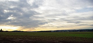
The Tualatin Plains are a prairie area in central Washington County, Oregon, United States. Located around the Hillsboro and Forest Grove areas, the plains were first inhabited by the Atfalati band of the Kalapuya group of Native Americans. Euro-American settlement began in the 1840s.
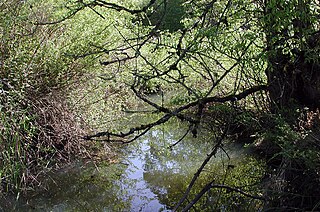
Fanno Creek is a 15-mile (24 km) tributary of the Tualatin River in the U.S. state of Oregon. Part of the drainage basin of the Columbia River, its watershed covers about 32 square miles (83 km2) in Multnomah, Washington, and Clackamas counties, including about 7 square miles (18 km2) within the Portland city limits.

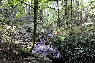
Balch Creek is a 3.5-mile (5.6 km) tributary of the Willamette River in the U.S. state of Oregon. Beginning at the crest of the Tualatin Mountains, the creek flows generally east down a canyon along Northwest Cornell Road in unincorporated Multnomah County and through the Macleay Park section of Forest Park, a large municipal park in Portland. At the lower end of the park, the stream enters a pipe and remains underground until reaching the river. Danford Balch, after whom the creek is named, settled a land claim along the creek in the mid-19th century. After murdering his son-in-law, he became the first person legally hanged in Oregon.

Cooper Mountain Nature Park is a 231 acres (93 ha) nature park in the Portland metropolitan area in the U.S. state of Oregon. Opened in 2009, the park is owned and operated by Metro, the regional government in the Oregon portion of the metro area. The park is named after Cooper Mountain, the primary geological feature in the area near Beaverton. Maintained by the regional Tualatin Hills Park and Recreation District, the natural area has 3.5 miles (5.6 km) of hiking trails. It is one of THPRD's two nature parks, along with the Tualatin Hills Nature Park.

Cornell Road is an east–west street and traffic corridor in the Portland metropolitan area, in Multnomah and Washington counties in the U.S. state of Oregon. It crosses the Tualatin Mountains between the Willamette Valley and the city of Portland on the east and the Tualatin Valley and the city of Hillsboro on the west.
Tanner Creek is a small tributary of the Willamette River in Portland in the U.S. state of Oregon. Named after a tannery owned by one of the city's founders, it begins in what is now the Sylvan–Highlands neighborhood in the Tualatin Mountains west of downtown. In the 19th century the creek flowed on the surface, running northeast across the city, past what later became Providence Park and into a shallow lake and wetlands in what became the Pearl District, bordering the river.

