
The Cascade Range or Cascades is a major mountain range of western North America, extending from southern British Columbia through Washington and Oregon to Northern California. It includes both non-volcanic mountains, such as the North Cascades, and the notable volcanoes known as the High Cascades. The small part of the range in British Columbia is referred to as the Canadian Cascades or, locally, as the Cascade Mountains. The latter term is also sometimes used by Washington residents to refer to the Washington section of the Cascades in addition to North Cascades, the more usual U.S. term, as in North Cascades National Park. The highest peak in the range is Mount Rainier in Washington at 14,411 feet (4,392 m).

The Pacific Northwest (PNW), sometimes referred to as Cascadia, is a geographic region in western North America bounded by the Pacific Ocean to the west and (loosely) by the Cascade Mountain Range on the east. Though no official boundary exists, the most common conception includes the Canadian province of British Columbia (BC) and the U.S. states of Idaho, Oregon, and Washington. Broader conceptions reach north into Southeast Alaska and Yukon, south into northern California, and east to the Continental Divide to include Western Montana and parts of Wyoming. Narrower conceptions may be limited to the coastal areas west of the Cascade and Coast mountains. The variety of definitions can be attributed to partially overlapping commonalities of the region's history, culture, geography, society, and other factors.

Larches are conifers in the genus Larix, of the family Pinaceae. Growing from 20 to 45 m tall, they are native to much of the cooler temperate northern hemisphere, on lowlands in the north and high on mountains further south. Larches are among the dominant plants in the boreal forests of Siberia and Canada. Although they are conifers, larches are deciduous trees that lose their needles in the autumn.

Multnomah Falls is a waterfall located in the Columbia River Gorge, east of Troutdale, between Corbett and Dodson, Oregon, United States. The waterfall is accessible from the Historic Columbia River Highway and Interstate 84. Spanning two tiers on basalt cliffs, it is the tallest waterfall in the state of Oregon at 620 ft (189 m) in height.
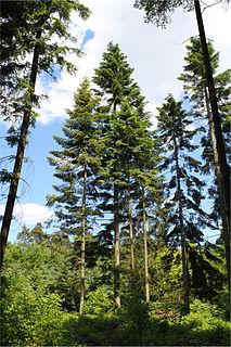
Abies grandis is a fir native to the Pacific Northwest and Northern California of North America, occurring at altitudes of sea level to 1,800 m. It is a major constituent of the Grand Fir/Douglas Fir Ecoregion of the Cascade Range.
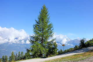
Larix decidua, the European larch, is a species of larch native to the mountains of central Europe, in the Alps and Carpathian Mountains as well as the Pyrenees, with disjunct lowland populations in northern Poland and southern Lithuania. Its life span has been confirmed to be close to 1000 years but is more often around 200 years. It is claimed that one of the larches planted by the second Duke of Atholl at Dunkeld in 1738 is still standing.

Larch Mountain is an extinct volcano near Portland, Oregon. The name is misleading, as no western larch can be found there. It received that name when early lumbermen sold the noble fir wood as larch. The peak can be reached between May and November on paved Larch Mountain Road, 16 miles (26 km) east of Corbett, Oregon, although the road is closed during the winter and spring months.
Larch Mountain may refer to:

Bridal Veil is a virtual ghost town located in Multnomah County, Oregon, United States. It was established in the 1880s during a logging boom by a logging company as it harvested timber on nearby Larch Mountain to be a company mill town around a sawmill. It had a close relationship with the logging town of Palmer for the first 50 years of its history. As of November 2011, all that remains of the town is a post office and a cemetery. The site is located near the west end of the Columbia River Gorge.

Strawberry Mountain Wilderness is a wilderness area of the Strawberry Mountain Range, within Malheur National Forest in the Blue Mountains of east Oregon. The area comprises 69,350 acres (28,060 ha), including mountain peaks and several lakes, and contains more than 125 miles (201 km) of hiking trails. Strawberry Mountain was designated wilderness under the Wilderness Act of 1964, and in 1984 more than doubled in size with the passage of the Oregon Wilderness Act. It is managed by the United States Forest Service.

Yamsay Mountain is a large shield volcano in the Cascade Range of south-central Oregon, located about 35 miles (56 km) east of Crater Lake on the border between Klamath County and Lake County. It is part of the Cascade Volcanic Arc but is located in a mountain range 30 to 50 miles behind the main Cascade volcanic front. The best known members of this enigmatic arc are the massive shields of Newberry Volcano, about 55 miles (89 km) farther north in Oregon, and Medicine Lake Volcano, about 80 miles (130 km) south in Northern California. Yamsay is the highest volcano in the eastern arc, almost 300 feet (90 m) higher than Newberry and Medicine Lake.
Krummholz or krumholtz — also called knieholz — is a type of stunted, deformed vegetation encountered in subarctic and subalpine tree line landscapes, shaped by continual exposure to fierce, freezing winds. Under these conditions, trees can only survive where they are sheltered by rock formations or snow cover. As the lower portion of these trees continues to grow, the coverage becomes extremely dense near the ground. In Newfoundland and Labrador, the formation is known as tuckamore. Krummholz trees are also found on beaches such as the Oregon coast, where trees can become much taller than their subalpine cousins.

The Larch Mountain salamander is a species of salamander in the family Plethodontidae endemic to the United States. It occurs in the Cascade Mountains of southern Washington and northern Oregon. In Washington, it occurs from the Columbia River Gorge to just north of Snoqualmie Pass. Its natural habitats are temperate forests and rocky areas. It is threatened by habitat loss.

Eagle Cap Wilderness is a wilderness area located in the Wallowa Mountains of northeastern Oregon, within the Wallowa–Whitman National Forest. The wilderness was established in 1940. In 1964, it was included in the National Wilderness Preservation System. A boundary revision in 1972 added 73,000 acres (30,000 ha) and the Wilderness Act of 1984 added 66,100 acres (26,700 ha) resulting in a current total of 361,446 acres, making Eagle Cap by far Oregon's largest wilderness area.

The Wenaha–Tucannon Wilderness is a federally designated wilderness area in the Blue Mountains of northeastern Oregon, and southeastern Washington, United States. It was created by the Endangered American Wilderness Act of 1978 and encompasses 177,423 acres (71,801 ha) in the Umatilla National Forest — 66,375 acres (26,861 ha) in Oregon and 111,048 acres (44,940 ha) in Washington.
The Steens Mountain Wilderness is a wilderness area surrounding a portion of Steens Mountain of southeastern Oregon in the United States. The reserve falls within the Steens Mountain Cooperative Management and Protection Area (CMPA). Both the reserve and the CMPA are administered by the Bureau of Land Management. The wilderness area encompasses 170,166 acres (68,864 ha) of the CMPA's total 428,156 acres (173,269 ha). 98,859 acres (40,007 ha) of the Wilderness are protected from grazing and free of cattle.

Brown Mountain is a small cinder cone on top of a shield volcano located in Cascade Volcanic Arc in Klamath and Jackson counties, Oregon. Most of the mountain, including its peak, is in western Klamath County, but its western flanks trail off into eastern Jackson County. It is 7,311 feet (2,228 m) above sea level, but is overshadowed by nearby 9,495-foot (2,894 m) Mount McLoughlin.

Sacajawea Peak is a peak in the Wallowa Mountains, in the U.S. state of Oregon. It is in the Eagle Cap Wilderness and the Wallowa–Whitman National Forest.

Larch Mountain is a 2,664-foot (812 m) summit in the Black Hills range of Thurston County, Washington state.


