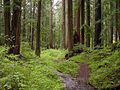
Larch Mountain (Multnomah County, Oregon)

Last updated
Larch Mountain
Larch Mountain-Oregon from Washough-Washington.JPG
Larch Mountain, as seen from Washougal, Washington.
Highest point
Elevation 4,061 ft (1,238 m)  NAVD 88 [1]
Prominence 975 ft (297 m) [2]
Coordinates 45°31′57″N122°5′17″W / 45.53250°N 122.08806°W / 45.53250; -122.08806 [1]
Geography
Location Multnomah County, Oregon, U.S.
Topo map USGS Multnomah Falls
Geology
Age of rock 1.8–1.4 Ma
Mountain type Shield volcano [3]
Volcanic field Boring Lava Field
Last eruption 1.4 Ma
Climbing
Easiest route paved road (June–October)
hiking trails (November–May)
View of Mt Hood from Larch Mountain Mt Hood From Larch Mountain.jpg
View of Mt Hood from Larch Mountain

Larch Mountain is an extinct volcano [4] near Portland, Oregon. The name is misleading, as no western larch (a large coniferous tree) can be found there. [5] It received that name when early lumbermen sold the noble fir wood as larch. The peak can be reached between May and November on paved Larch Mountain Road, 16 mi (26 km) east of Corbett, Oregon, although the road is closed during the winter and spring months. [6] The road leading to Larch Mountain from the Historic Columbia River Highway is 14 miles long, which closed at milepost 10 from Nov. through late May or early June due to snow. [7]

Contents

Geography

Larch Mountain is located in Multnomah County, Oregon approximately 40 mi (64 km) east of Portland, above the Columbia River Gorge. Although it has an elevation of 4,061 ft (1,238 m), [1] its prominence above the surrounding terrain is only 975 ft (297 m). [2] The summit of the mountain is accessible by Larch Mountain Road between May and November, which branches off from the Historic Columbia River Highway 2 mi (3.2 km) east of Corbett. Due to the risk of driving on the mountain's upper slopes in winter weather, the road closes during the winter months at milepost 10. [8] [9]

History

In 1879, Amos James Moore was the first known person to advocate for the logging and settling of Larch Mountain. Attractive due to its proximity to Portland and the Columbia River, it contained what were considered some of the highest-quality cedar, hemlock, and fir trees in the United States. In 1886, the Bridal Veil Lumbering Company started logging and constructed a lumber mill, followed a year later by the Latourrel Falls Wagon Road and Lumber Company. The operation rapidly expanded with the construction of a wooden plank road extending from Larch Mountain to the railroad line near the river, allowing for the large-scale logging of the mountain. The Bridal Veil Lumbering company became known for the high quality of its timber. [10]

In 1902, a fire swept through one of the mills, completely destroying it as well as the town. Both were soon rebuilt in new locations. This event is often heralded as the start of the decline of the large-scale Victorian logging practices, which were replaced by more modern techniques. Only a few remnants of the former system exist today. Logging continued in the new forms on the mountain for several more decades. In 1928, the United States Forest Service began reforesting the slopes of Larch Mountain, so that more lumber could be produced. A fire in 1936 marked the end of the timber business on the mountain. Causing around $100,000 of damage, it severely damaged the lumber mill, which was not rebuilt due to the depletion of the timber supply on the mountain. [10]

Geology

Larch Mountain is the remnant of an ancient shield volcano, with broad slopes covering tens of square kilometers. It is currently the tallest peak in the Boring Lava Field, a volcanic field active during the Plio-Pleistocene time frame. Active between 1.8 and 1.4 million years ago, the volcano is composed mainly of basalts, although the summit at Sherrard Point is composed mainly of iron-rich andesite. Larch Mountain's basalt is tough to distinguish from the surrounding Columbia River Basalt, although the Columbia River Basalt is slightly lighter in color and less brittle. [11] Sherrard Point is the eroded remains of the original volcanic plug. [12]

Sherrard Point was exposed during the last glacial period, when the majority of the mountain's peak was destroyed by glaciers. The glaciers carved a large cirque into the mountain, forming a large lake. Over time, the lake was filled with sediment, and today the area is now a large meadow. [13]

Biology

Larch Mountain contains some of the largest old-growth forest stands left in the Columbia River Gorge area, characterized by the presence of many nurse logs. Dominant tree species include pacific silver fir, grand fir, Douglas fir, and western hemlock. [13]

Recreation

The Larch Mountain area contains multiple popular hiking trails. The Larch Mountain Trail #441 begins near the Columbia River at the Multnomah Falls Lodge and roughly follows Multnomah Creek, passing several waterfalls including the well-known Multnomah Falls, Weisendanger Falls, and Ecola Falls. The trail ends at the Larch Mountain parking lot, [14] at a picnic area. [6] The Sherrard Point Trail #443 leads from this area to Sherrard Point at the pinnacle. [14] Sherrard Point offers an outstanding view of the nearby Cascade Range volcanoes Mount Hood, Mount Adams, Mount Jefferson, Mount Rainier, and Mount St. Helens. Elevation plaques are provided, showing the elevation of said volcanoes.

A loop around Larch Mountain itself is formed by the Larch Mountain Trail, the Multnomah Creek Way Trail #444, and the Oneonta Trail #424. [15]

See also

Related Research Articles

<span class="mw-page-title-main">Cascade Range</span> Mountain range in western North America

The Cascade Range or Cascades is a major mountain range of western North America, extending from southern British Columbia through Washington and Oregon to Northern California. It includes both non-volcanic mountains, such as many of those in the North Cascades, and the notable volcanoes known as the High Cascades. The small part of the range in British Columbia is referred to as the Canadian Cascades or, locally, as the Cascade Mountains. The highest peak in the range is Mount Rainier in Washington at 14,411 feet (4,392 m).

<span class="mw-page-title-main">Multnomah Falls</span> Waterfall in Oregon, U.S.

Multnomah Falls is a waterfall located on Multnomah Creek in the Columbia River Gorge, east of Troutdale, between Corbett and Dodson, Oregon, United States. The waterfall is accessible from the Historic Columbia River Highway and Interstate 84. Spanning two tiers on basalt cliffs, it is the tallest waterfall in the state of Oregon at 620 ft (189 m) in height. The Multnomah Creek Bridge, built in 1914, crosses below the falls, and is listed on the National Register of Historic Places.

<span class="mw-page-title-main">Mount Jefferson (Oregon)</span> Stratovolcano in the Cascade Range, Oregon, US

Mount Jefferson is a stratovolcano in the Cascade Volcanic Arc, part of the Cascade Range in the U.S. state of Oregon. The second highest mountain in Oregon, it is situated within Linn County, Jefferson County, and Marion County and forms part of the Mount Jefferson Wilderness. Due to the ruggedness of its surroundings, the mountain is one of the hardest volcanoes to reach in the Cascades. It is also a popular tourist destination despite its remoteness, with recreational activities including hiking, backpacking, mountaineering, and photography. Vegetation at Mount Jefferson is dominated by Douglas fir, silver fir, mountain hemlock, ponderosa pine, lodgepole pine, and several cedar species. Carnivores, insectivores, bats, rodents, deer, birds, and various other species inhabit the area.

<span class="mw-page-title-main">Mount Thielsen</span> Extinct shield volcano in Oregon

Mount Thielsen, or Big Cowhorn, is an extinct shield volcano in the Oregon High Cascades, near Mount Bailey. Because eruptive activity ceased 250,000 years ago, glaciers have heavily eroded the volcano's structure, creating precipitous slopes and a horn-like peak. The spire-like shape of Thielsen attracts lightning strikes and creates fulgurite, an unusual mineral. The prominent horn forms a centerpiece for the Mount Thielsen Wilderness, a reserve for recreational activities such as skiing and hiking. Thielson is one of Oregon's Matterhorns.

<span class="mw-page-title-main">Indian Heaven</span> Volcanic field in United States of America

Indian Heaven is a volcanic field in Skamania County in the state of Washington, in the United States. Midway between Mount St. Helens and Mount Adams, the field dates from the Pleistocene to the early Holocene epoch. It trends north to south and is dominated by six small shield volcanoes; these shields are topped by small spatter and cinder cones, and the field includes a number of subglacial volcanoes and tuyas. The northernmost peak in the field is Sawtooth Mountain and the southernmost is Red Mountain; its highest point is Lemei Rock at an elevation of 5,925 feet (1,806 m).

<span class="mw-page-title-main">Forest Park (Portland, Oregon)</span> Public municipal park west of downtown Portland, Oregon

Forest Park is a public municipal park in the Tualatin Mountains west of downtown Portland, Oregon, United States. Stretching for more than 8 miles (13 km) on hillsides overlooking the Willamette River, it is one of the country's largest urban forest reserves. The park, a major component of a regional system of parks and trails, covers more than 5,100 acres (2,064 ha) of mostly second-growth forest with a few patches of old growth. About 70 miles (110 km) of recreational trails, including the Wildwood Trail segment of the city's 40-Mile Loop system, crisscross the park.

<span class="mw-page-title-main">Bridal Veil Falls (Oregon)</span> Waterfall located in Oregon, United States

The Bridal Veil Falls is a waterfall located on Bridal Veil Creek along the Columbia River Gorge in Multnomah County, Oregon, United States. The waterfall is accessible from the historic Columbia River Highway and Interstate 84. Spanning two tiers on basalt cliffs, it is the only waterfall which occurs below the historic Columbia Gorge Scenic Highway. The Bridal Veil Falls Bridge, built in 1914, crosses over the falls, and is listed on the National Register of Historic Places.

<span class="mw-page-title-main">Boring Lava Field</span> Plio-Pleistocene volcanic field in Oregon, United States

The Boring Lava Field is a Plio-Pleistocene volcanic field with cinder cones, small shield volcanoes, and lava flows in the northern Willamette Valley of the U.S. state of Oregon and adjacent southwest Washington. The field got its name from the town of Boring, Oregon, located 12 miles (20 km) southeast of downtown Portland. Boring lies southeast of the densest cluster of lava vents. The zone became volcanically active about 2.7 million years ago, with long periods of eruptive activity interspersed with quiescence. Its last eruptions took place about 57,000 years ago at the Beacon Rock cinder cone volcano; the individual volcanic vents of the field are considered extinct, but the field itself is not.

<span class="mw-page-title-main">Bull Run River (Oregon)</span> Tributary of the Sandy River in Oregon, United States

The Bull Run River is a 21.9-mile (35.2 km) tributary of the Sandy River in the U.S. state of Oregon. Beginning at the lower end of Bull Run Lake in the Cascade Range, it flows generally west through the Bull Run Watershed Management Unit (BRWMU), a restricted area meant to protect the river and its tributaries from contamination. The river, impounded by two artificial storage reservoirs as well as the lake, is the primary source of drinking water for the city of Portland, Oregon.

<span class="mw-page-title-main">Yacolt Burn</span> Group of wildfires (1902)

The Yacolt Burn is the collective name for dozens of fires in Washington state and Oregon occurring between September 8 and September 12, 1902, causing 38 deaths in the Lewis River area, at least nine deaths by fire in Wind River and 18 deaths in the Columbia River Gorge.

<span class="mw-page-title-main">Black Butte (Oregon)</span> Extinct stratovolcano in US

Black Butte is an extinct stratovolcano in the U.S. state of Oregon. Located in Jefferson County, it is part of Deschutes National Forest. Black Butte forms part of the Cascade volcanic arc. The butte lies just south of the Metolius Springs, which merge to form the headwaters of the Metolius River. The Metolius River's basin sustains a wide array of plant life, large and small mammals, and more than 80 bird species.

<span class="mw-page-title-main">Rocky Butte</span> Extinct cinder cone butte in Portland, Oregon

Rocky Butte is an extinct cinder cone butte in Portland, Oregon, United States. It is also part of the Boring Lava Field, a group of volcanic vents and lava flows throughout Oregon and Washington state. The volcano erupted between 285,000 and 500,000 years ago.

<span class="mw-page-title-main">Powell Butte</span> Extinct cinder cone butte in Portland, Oregon, U.S.

Powell Butte is an extinct cinder cone butte in Portland, Oregon, United States. It is part of the Boring Lava Field, which includes more than 80 small volcanic edifices and lava flows in the Portland–Vancouver metropolitan area. The region around Powell Butte has a cool climate, and the butte and its surroundings feature meadows, rivers, and mixed forests. Powell Butte hosts the Powell Butte Nature Park, which includes about 612 acres (2.48 km2) of trails for biking, hiking, and horseback riding.

<span class="mw-page-title-main">Bridal Veil, Oregon</span> Unincorporated community in the state of Oregon, United States

Bridal Veil is a virtual ghost town located in Multnomah County, Oregon, United States. It was established in the 1880s during a logging boom by a logging company as it harvested timber on nearby Larch Mountain to be a company mill town around a sawmill. It had a close relationship with the logging town of Palmer for the first 50 years of its history. As of November 2011, all that remains of the town is a post office and a cemetery. The site is located near the west end of the Columbia River Gorge.

<span class="mw-page-title-main">Yamsay Mountain</span> Shield volcano mountain in Oregon, U.S.

Yamsay Mountain is a large shield volcano in the Cascade Range of south-central Oregon, located about 35 miles (56 km) east of Crater Lake on the border between Klamath County and Lake County. It is part of the Cascade Volcanic Arc but is located in a mountain range 30 to 50 miles behind the main Cascade volcanic front. The best known members of this enigmatic arc are the massive shields of Newberry Volcano, about 55 miles (89 km) farther north in Oregon, and Medicine Lake Volcano, about 80 miles (130 km) south in Northern California. Yamsay is the highest volcano in the eastern arc, almost 300 feet (90 m) higher than Newberry and Medicine Lake.

<span class="mw-page-title-main">Tryon Creek</span> Tributary of the Willamette River in Oregon

Tryon Creek is a 4.85-mile (7.81 km) tributary of the Willamette River in the U.S. state of Oregon. Part of the drainage basin of the Columbia River, its watershed covers about 6.5 square miles (16.8 km2) in Multnomah and Clackamas counties. The stream flows southeast from the Tualatin Mountains through the Multnomah Village neighborhood of Portland and the Tryon Creek State Natural Area to the Willamette in the city of Lake Oswego. Parks and open spaces cover about 21 percent of the watershed, while single-family homes dominate most of the remainder. The largest of the parks is the state natural area, which straddles the border between the two cities and counties.

<span class="mw-page-title-main">Balch Creek</span> Tributary of Willamette River in Oregon, United States

Balch Creek is a 3.5-mile (5.6 km) tributary of the Willamette River in the U.S. state of Oregon. Beginning at the crest of the Tualatin Mountains, the creek flows generally east down a canyon along Northwest Cornell Road in unincorporated Multnomah County and through the Macleay Park section of Forest Park, a large municipal park in Portland. At the lower end of the park, the stream enters a pipe and remains underground until reaching the river. Danford Balch, after whom the creek is named, settled a land claim along the creek in the mid-19th century. After murdering his son-in-law, he became the first person legally hanged in Oregon.

Trout Creek Hill is a small Pleistocene basaltic shield volcano in Washington, United States. Located in Skamania County, Trout Creek Hill rises to an elevation of 2,946 feet (898 m). It is part of the Cascade Volcanic Arc, located in the Marble Mountain-Trout Creek Hill volcanic field.

<span class="mw-page-title-main">Mark O. Hatfield Memorial Trail</span> Proposed hiking trail in Oregon, U.S.

The Mark O. Hatfield Memorial Trail is a proposed long-distance trail through the Columbia River Gorge in Multnomah County and Hood River County, Oregon. The trail will be approximately 60 miles, although the trail is still unofficial and its exact course is yet to be determined. The trail was first proposed by Tom Kloster on June 20, 2010, and suggests the Mark O. Hatfield Memorial Trail use existing trails from Multnomah Falls to Starvation Creek. Prior to this suggestion, the Talapus Trail, connecting the Pacific Crest Trail and Larch Mountain was slated for construction in 1974. Hikers openly used trails in the Bull Run Watershed into the 1980s, including the Talapus Trail.

<span class="mw-page-title-main">Eagle Creek Fire</span> Major 2017 wildfire in Columbia Gorge, Oregon

The Eagle Creek Fire was a destructive wildfire in the Columbia River Gorge, largely in the U.S. state of Oregon, with smaller spot-fires in Washington. The fire was started on September 2, 2017, by a 15-year-old boy igniting fireworks during a burn ban. The fire burned 50,000 acres, and burned for three months, before being declared completely contained. As late as May 29, 2018, it was still found smoldering in some areas.

References

  1. 1 2 3 "Larch Reset". NGS Data Sheet. National Geodetic Survey, National Oceanic and Atmospheric Administration, United States Department of Commerce . Retrieved 2008-11-18.
  2. 1 2 "Larch Mountain, Oregon". peakbagger.com. Archived from the original on 2006-11-08. Retrieved 2008-04-01.
  3. "The Boring Volcanic Field – Hills of the Portland Basin". USGS Cascades Volcano Observatory. Archived from the original on 2015-12-22. Retrieved 2015-12-29.
  4. Cascades Volcano Observatory (2014-06-11). "The Boring Volcanic Field — Hills of the Portland Basin". USGS. Archived from the original on 2015-02-21. Retrieved 2015-02-21. All existing Boring Volcanic centers are extinct, but the Boring Volcanic Field presumably is not. Since activity started 2.6 million years ago, it is rare that 50,000 years passed without an eruption. The probability of an eruption in the Portland/Vancouver metro area however, is very low.
  5. Reed, Ione (1971-12-25). "What, Indeed, Is in a Name?". Eugene Register-Guard. p. 8. Archived from the original on 2021-10-26. Retrieved 2015-04-30.
  6. 1 2 "Larch Mountain Picnic Area". United States Forest Service. Archived from the original on 2015-09-24. Retrieved 2015-08-11.
  7. "Larch Mountain Trail (#441)". 2022-01-15. Archived from the original on 2022-01-15. Retrieved 2022-01-15.
  8. House, Kelly (2015-11-20). "Upper Larch Mountain Road to close for winter next week". The Oregonian . Portland, Oregon. Archived from the original on 2015-11-25. Retrieved 2015-12-28.
  9. "Larch Mountain Trailhead". United States Forest Service. Archived from the original on 2016-01-21. Retrieved 2015-12-28.
  10. 1 2 Prohaska, Sharr (1992). History of the Development of Bridal Veil, Oregon and the Bridal Veil Lumbering Company: Report for Multnomah County (PDF) (Report) (June ed.). Archived (PDF) from the original on 2015-12-23. Retrieved 2015-12-23.
  11. Bishop, Ellen Morris; Allen, John Eliot (2004). Hiking Oregon's Geology (Second ed.). The Mountaineers Books. pp. 108–110. ISBN   9780898868470. Archived from the original on 2023-04-01. Retrieved 2020-12-12.
  12. Hart, Steve (2015-02-26). "Sherrard Point". OregonHikers.org. Archived from the original on 2015-08-23. Retrieved 2015-08-11.
  13. 1 2 Lorain, Douglas (2008-03-05). Afoot and Afield: Portland/Vancouver: A Comprehensive Hiking Guide. Berkeley, California: Wilderness Press. pp. 217–219. ISBN   978-0-89997-468-2.
  14. 1 2 Hart, Steve (2010-02-18). "Larch Mountain Hike". OregonHikers.org. Archived from the original on 2015-12-22. Retrieved 2015-12-20.
  15. "Multnomah Creek Way Trail #444". United States Forest Service. Archived from the original on 2015-12-22. Retrieved 2015-12-21.