Ochoco Mountains

Last updated
Ochoco Mountains
Steins Pillar near Prineville.jpg
Steins Pillar in ponderosa pine forest
Highest point
PeakLookout Mountain [1]
Elevation 6,926 ft (2,111 m)
Coordinates 44°19′37″N120°22′24″W / 44.32694°N 120.37333°W / 44.32694; -120.37333 [2]
Dimensions
Length114 mi (183 km)north–south
Width86 mi (138 km)
Geography
USA Oregon relief location map.svg
Red triangle with thick white border.svg
Location of the Ochoco Mountains in Oregon
CountryUnited States
State Oregon
Counties [3] Crook, Wheeler and Grant
Range coordinates 44°26′35″N120°23′37″W / 44.44306°N 120.39361°W / 44.44306; -120.39361 Coordinates: 44°26′35″N120°23′37″W / 44.44306°N 120.39361°W / 44.44306; -120.39361 [3]
Parent range Blue Mountains province
Geology
Age of rock Permian, Triassic, Jurassic and Eocene
Type of rock Accreted and erupted igneous rock

The Ochoco Mountains are a mountain range in central Oregon in the United States, located at the western end of the Blue Mountains. They were formed when Permian, Triassic, and Jurassic rocks were slowly uplifted by volcanic eruptions to form the Clarno Formation. Today, the highest point in the range is Lookout Mountain. The dominant vegetation on the west side of the range is old-growth ponderosa pine; on the east side, western juniper is common. The western area of the mountains is administered by the Ochoco National Forest, while the southeastern section is part of the Malheur National Forest. The Ochoco Mountains are used for hiking, camping, bird watching, rockhounding, and hunting, as well as cross-country skiing in the winter.

Contents

Geography

The Ochoco Mountains run 114 miles (183 km) north to south and 86 miles (138 km) east to west. [1] The eight highest peaks in the range are: [1]

Geology

The Ochoco Mountains in central Oregon form the western end of the Blue Mountains. The Blue Mountains are not a single cohesive range, but rather a complex of ranges and inter-mountain basins and valleys that extend from southeast Washington into central Oregon, ending near Prineville. The Ochoco portion of the province is part of a wide uplifted plateau made of rocks from the Permian, Triassic, and Jurassic periods (300 to 200 million years old) that were transported by the Pacific Plate and accreted in the late Mesozoic era (about 100 million years ago) as part of a vast shallow sea, then slowly uplifted by volcanic eruptions during the Eocene epoch (50 to 37 million years ago) to form the Clarno Formation. From 37 to 17 million years ago, eruptions in the western Cascade Range spread ash across eastern Oregon, forming the John Day Formation. From 17 to 14 million years ago, major volcanic eruptions covered much of the province with basalt flows, creating the Columbia River Basalt Group. Since then, continued faulting and uplift has resulted in a deeply eroded landscape. Steins Pillar is an excellent example of this erosion. [4]

During the Eocene epoch, central Oregon volcanoes deposited layers of lava and ash up to 1,000 feet (300 m) thick over the area that is now the Ochoco Mountains. Large mudflows called lahars were also common during that period. These mudflows often covered and preserved the plants and animals, resulting in fossil beds. Today, fossils of prehistoric trees, fruits, nuts, and flowers can be found in the Ochoco Mountains along with fossilized animals including horses, camels, rhinoceros, and hippopotami. [5]

Ecology

The vegetation in the Ochoco Mountains ranges from old-growth ponderosa pine on the western slopes and in the mountain valleys to western juniper and sagebrush on the eastern and southern slopes. The high mountain meadows host a wide variety of wild flowers and even ferns in some areas. Big Summit Prairie near the center of the Ochocos is well known for its spring wild flower displays. [6]

Ponderosa pine forest in the Deep Springs area Deep Springs area, Ochoco National Forest, Oregon.jpg
Ponderosa pine forest in the Deep Springs area

Ponderosa pine is the dominant tree species in most parts of the Ochoco Mountains. These pines are common at elevations from 3,000 to 6,000 feet (910 to 1,830 m) above sea level. Manzanita, antelope bitterbrush, and ceanothus are common shrubs in the pine-dominated areas with Idaho fescue and Ross' sedge as the main ground cover. Ponderosa pine forests are tolerant of drought and low-intensity wildfires. Birds commonly found in the pine forests of the Ochoco Mountains include the northern flicker, hairy woodpecker, red-tailed hawk, and Steller's jay. Central Oregon's ponderosa pine forests are an important winter range for mule deer and Rocky Mountain elk. [7]

On the drier, eastern side of the Ochoco Mountains, the western juniper trees survive on as little as 8 inches (200 mm) of precipitation per year. The range's juniper woodlands cover wide areas from 3,000 to 4,000 feet (910 to 1,220 m) in elevation. Antelope bitterbrush and sagebrush are common shrubs in these areas with Idaho fescue and bluebunch wheatgrass as the main ground cover. Juniper woodlands are home to mountain bluebirds, Townsend's solitaires, and ferruginous hawks during the spring and summer. There are also many small mammals and lizards that are prey for coyote. [7]

Camas flower at Big Summit Prairie Small camas flower, Big Summit Prairie, Oregon.jpg
Camas flower at Big Summit Prairie

Big Summit Prairie is a large high-country meadow covering 20 square miles (52 km2) in the middle of the Ochoco Mountains. The prairie is covered by water-loving grasses, overgrown by willows and shrubs in some areas. Tufted hairgrass, elephant's head, and horsetail are common ground cover in the meadowlands. Quaking aspen with shrubby undergrowth attract wildlife not found in other parts of the Ochoco Mountains. Common birds include sandhill crane, Wilson's snipe, long-billed curlew, and northern harrier. Even the rare dickcissel has been sighted at Big Summit Prairie. Larger animals include mule deer, pronghorn, Belding's ground squirrel, northern pocket gopher, meadow mice, and coyotes. Also, Rocky Mountain elk move into the area in the fall. [8] [9]

Big Summit Prairie is particularly well known for its wildflowers and butterflies. From April through June, flowers cover Big Summit meadow. The first wildflowers to bloom are usually grass widow, wild parsley, and shooting stars. From May through June, Wyethia , buttercups, and camas display their colors. In drier areas, bitterroot bloom with large white and pink flowers. In June and July, other flowers take over the display including Missouri iris, larkspur, Indian paintbrush, checkermallow, and arrowleaf balsamroot. One notable plant is Peck's mariposa lily, a type of Calochortus with lavender petals. This plant is found only in the Ochoco Mountains. Butterfly species common to the Big Summit Prairie include hairstreak, skipper, eastern tailed-blue, Lycaenidae, checkerspot, fritillary, swallowtail, admiral, and tortoiseshell. [8] [9]

Human uses

Most of the Ochoco Mountains are public lands administered by the United States Forest Service. The Ochoco National Forest is responsible for most of the mountain area; however, the southeastern part of the range is in the Malheur National Forest. Some land in the Ochoco area is also administered by the Bureau of Land Management. Hiking, fishing, camping, hunting, horseback riding, bird watching, and rockhounding are all popular activities. [10]

The Ochoco National Forest maintains 27 campgrounds in or near the Ochoco Mountains. The largest are the Antelope Flat Reservoir, Ochoco Divide, Walton Lake, and Wildcat campgrounds. [11] The Malheur National Forest has several campgrounds in the Ochoco Mountains as well. The largest is the campground at Delintment Lake. [12]

Thundereggs like these are found at Whistle Springs. Thundereggs from Ochoco Mountains, Oregon.jpg
Thundereggs like these are found at Whistle Springs.

The unique geology of the Ochoco Mountains is such that a wide variety of rock types are located in a relatively small area. This brings rockhounds to the area every summer. The Bureau of Land Management and the Ochoco National Forest both have designated areas where rockhounds can search for agate, jasper, petrified wood, petrified moss, and dendrite. These rock collection sites are for personal use only; gathering rocks for commercial purposes is prohibited. Thundereggs can be found at Whistle Springs. Even though the area has been worked by rockhounds for many years, quality thundereggs are still found at the site. There are also some rare rocks and minerals in central Oregon in or near the Ochoco Mountains, including opals, amethyst, gem quality calcite, cinnabar, selenite, gypsum, and amygdaloid nodules. [18] [19]

Wilderness areas

The Ochoco National Forest has three wilderness areas in the Ochoco Mountains. They are the Bridge Creek Wilderness, the Black Canyon Wilderness, and the Mill Creek Wilderness.

Related Research Articles

<span class="mw-page-title-main">Crook County, Oregon</span> County in Oregon, United States

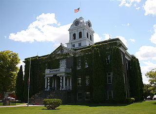
Crook County is one of the 36 counties in the U.S. state of Oregon. As of the 2020 census, the population was 24,738. The county seat is Prineville. The county is named after George Crook, a U.S. Army officer who served in the American Civil War and various Indian Wars.

<span class="mw-page-title-main">Three Sisters Wilderness</span>

The Three Sisters Wilderness is a wilderness area in the Cascade Range, within the Willamette and Deschutes National Forests in Oregon, United States. It comprises 286,708 acres (1,160.27 km2), making it the second largest wilderness area in Oregon, after the Eagle Cap Wilderness. It was established by the United States Congress in 1964 and is named for the Three Sisters volcanoes. The wilderness boundary encloses the Three Sisters as well as Broken Top, which is southeast of South Sister.

<span class="mw-page-title-main">Ochoco National Forest</span> National Forest in Oregon

The Ochoco National Forest is located in the Ochoco Mountains in Central Oregon in the United States, north and east of the city of Prineville, location of the national forest headquarters. It encompasses 850,000 acres (3,440 km2) of rimrock, canyons, geologic oddities, dense pine forests, and high desert terrain, as well as the headwaters of the North Fork Crooked River. A 1993 Forest Service study estimated that the extent of old growth in the forest was 95,000 acres (38,000 ha).

<span class="mw-page-title-main">Central Oregon</span> Region in Oregon, United States

Central Oregon is a geographic region in the U.S. state of Oregon and is traditionally considered to be made up of Deschutes, Jefferson, and Crook counties. Other definitions include larger areas, often encompassing areas to the north towards the Columbia River, eastward towards Burns, or south towards Klamath Falls. These three counties have a combined population of 200,431 as of the 2010 census, with Deschutes the largest of the three counties, having approximately four times the population of the other two counties combined. As of 2015, the most populous city in the region is Bend, with an estimated 87,014 residents. As defined by the three county definition, Central Oregon covers 7,833 square miles (20,290 km2) of land. Central Oregon has had 3 record tourism years beginning in 2012. Over 2.2 million people visited Central Oregon in 2012 and again in 2013.

<span class="mw-page-title-main">Diamond Peak Wilderness</span>

The Diamond Peak Wilderness is a wilderness area straddling the Cascade crest and includes the Diamond Peak volcano. It is located within two National Forests - the Willamette National Forest on the west and the Deschutes National Forest on the east.

<span class="mw-page-title-main">Deschutes National Forest</span> National forest in the U.S. state of Oregon

The Deschutes National Forest is a United States National Forest located in parts of Deschutes, Klamath, Lake, and Jefferson counties in central Oregon. It comprises 1.8 million acres (7,300 km2) along the east side of the Cascade Range. In 1908, the Deschutes National Forest was established from parts of the Blue Mountains, Cascade, and Fremont National Forests. In 1911, parts of the Deschutes National Forest were split off to form the Ochoco and Paulina National Forests, and parts of the Cascade and Oregon National Forests were added to the Deschutes. In 1915, the lands of the Paulina National Forest were rejoined to the Deschutes National Forest. A 1993 Forest Service study estimated that the extent of old growth in the forest was 348,100 acres (140,900 ha). Within the boundaries of the Deschutes National Forest is the Newberry National Volcanic Monument, containing cinder cones, lava flows, and lava tubes. The Deschutes National Forest as a whole contains in excess of 250 known caves. The forest also contains five wilderness areas, six National Wild and Scenic Rivers, the Oregon Cascade Recreation Area, and the Metolius Conservation Area. Forest headquarters are located in Bend, Oregon. There are local ranger district offices in Bend, Crescent, and Sisters.

<span class="mw-page-title-main">Strawberry Mountain Wilderness</span>

Strawberry Mountain Wilderness is a wilderness area of the Strawberry Mountain Range, within Malheur National Forest in the Blue Mountains of east Oregon. The area comprises 69,350 acres (28,060 ha), including mountain peaks and several lakes, and contains more than 125 miles (201 km) of hiking trails. Strawberry Mountain was designated wilderness under the Wilderness Act of 1964, and in 1984 more than doubled in size with the passage of the Oregon Wilderness Act. It is managed by the United States Forest Service.

<span class="mw-page-title-main">Mount Washington Wilderness</span>

The Mount Washington Wilderness is a wilderness area located on and around Mount Washington in the central Cascade Range of Oregon in the United States. The wilderness was established in 1964 and comprises 54,278 acres (219.66 km2) of the Willamette National Forest and Deschutes National Forest. It is administered by the U.S. Forest Service.

<span class="mw-page-title-main">Mount Jefferson Wilderness</span>

The Mount Jefferson Wilderness is a wilderness area located on and around Mount Jefferson in the central Cascade Range of Oregon in the United States. The wilderness lies within the Willamette National Forest and Deschutes National Forest. The wilderness area covers 111,177 acres (449.92 km2), with more than 150 lakes. It also has 190 miles (310 km) of trails, including 40 miles (64 km) of the Pacific Crest National Scenic Trail. Three Fingered Jack and Mount Jefferson are both prominent features of the wilderness area. Mount Jefferson Wilderness is the second most visited Oregon wilderness area after the Three Sisters Wilderness.

<span class="mw-page-title-main">Crooked River (Oregon)</span> River in Oregon, United States

The Crooked River is a tributary, 125 miles (201 km) long, of the Deschutes River in the U.S. state of Oregon. The river begins at the confluence of the South Fork Crooked River and Beaver Creek. Of the two tributaries, the South Fork Crooked River is the larger and is sometimes considered part of the Crooked River proper. A variant name of the South Fork Crooked River is simply "Crooked River". The Deschutes River flows north into the Columbia River.

<span class="mw-page-title-main">Tumalo State Park</span> State park in Oregon, United States

Tumalo State Park is a well-developed state park in Deschutes County, Oregon, United States. Established in 1954, the park is located northwest of the city of Bend and along the Deschutes River at a site home to many bird species. The park is popular for picnics, swimming, fishing, hiking, and camping, and is open year-round.

Bridge Creek Wilderness is a wilderness area located in the Ochoco Mountains of central Oregon, within the Ochoco National Forest. It was established in 1984 and comprises 5,400 acres (2,185 ha), making it one of the smallest Wilderness areas in the state.

Mill Creek Wilderness is a wilderness area located in the Ochoco National Forest of central Oregon. It was established in 1984 and comprises 17,400 acres (7,040 ha). Of the three wilderness areas in the Ochoco National Forest - Mill Creek, Bridge Creek, and Black Canyon - Mill Creek is the largest and most heavily used.

<span class="mw-page-title-main">Blue Mountains (ecoregion)</span> Temperate coniferous forests ecoregion of the United States

The Blue Mountains ecoregion is a Level III ecoregion designated by the United States Environmental Protection Agency (EPA) in the Pacific Northwest, mainly in the state of Oregon, with small areas over the state border in Idaho and southeastern Washington. It is also contiguous with the World Wildlife Fund's Blue Mountain forests ecoregion.

<span class="mw-page-title-main">Cabin Lake Guard Station</span> United States historic place

The Cabin Lake Guard Station is a Forest Service compound consisting of six simple rustic buildings located in the Deschutes National Forest in central Oregon. It was originally built as a district ranger station for the Fort Rock Ranger District. It was later converted to a summer guard station. The guard station is now closed, but the adjacent campground is open. While still very remote, it is a popular location for bird watching and nature photography. The Cabin Lake Guard Station is listed on the National Register of Historic Places.

<span class="mw-page-title-main">Allison Guard Station</span> United States historic place

The Allison Guard Station is a Forest Service compound consisting of eight rustic buildings located in the Malheur National Forest in the Ochoco Mountains of eastern Oregon. It was originally built as a district ranger station for the Snow Mountain Ranger District. It was later converted to a summer guard station. Today, it is an active Forest Service guard station with a crew of twelve fire fighters on station during the summer fire season. The station's oldest building, the Donnelly Cabin, is currently listed on the National Register of Historic Places as the "Allison Ranger Station". Most of the other buildings at the Allison Guard Station are eligible for historic designation, but are not yet listed on the National Register.

<span class="mw-page-title-main">Paulina Lake Guard Station</span> United States historic place

The Paulina Lake Guard Station is a Forest Service building located in the Newberry National Volcanic Monument in Central Oregon. The guard station was built by the Civilian Conservation Corps to house the seasonal assistant ranger responsible for patrolling the forest around Paulina Lake. Because of its rustic architecture, the guard station was listed on the National Register of Historic Places in 1986.

<span class="mw-page-title-main">Suttle Lake (Oregon)</span> Lake in Oregon, United States of America

Suttle Lake is a natural lake near the crest of the Cascade Range in central Oregon, United States, covering 253 acres (1.02 km2). It was named in honor of John Settle, whose name was misspelled when the lake was officially recorded as a geographic feature. Today, the lake is located within the Deschutes National Forest and serves as one of central Oregon's most popular outdoor recreation sites, with three large campgrounds and two day-use areas along the north, west, and south shores of the lake. The Oregon Department of Fish and Wildlife regularly stocks the lake with rainbow trout.

<span class="mw-page-title-main">Elliott Corbett Memorial State Recreation Site</span> State park in Oregon, United States

Elliott Corbett Memorial State Recreation Site is a state park along the south shore of Blue Lake Crater in Jefferson County, Oregon, United States. The park is named in honor of Elliott R. Corbett II, who was killed while serving in the United States Army during World War II. It includes 63 acres (25 ha) of wilderness land with very few park facilities. Corbett State Park is administered by the Oregon Parks and Recreation Department.

<span class="mw-page-title-main">Todd Lake (Oregon)</span> Body of water

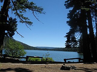
Todd Lake is a natural lake near the crest of the Cascade Range in central Oregon in the United States. The lake covers 45 acres (18 ha). It is named in honor of John Y. Todd, an early settler in Central Oregon. Today, the lake and surrounding forest is managed by the United States Forest Service as part of the Deschutes National Forest. The Oregon Department of Fish and Wildlife regularly stocks the lake with brook trout. There is a day-use area and a rustic campground located on the west shore of the lake. In the summer, Todd Lake is a popular outdoor recreation site for picnicking, fishing, hiking, and nature viewing. In the winter, trails in the Todd Lake area are used for cross-country skiing and snowshoeing.

References

  1. 1 2 3 "Ochoco Mountains", Peakbagger.com Database, Geographic Research Systems, Peakbagger.com, Seattle, Washington, 23 January 2015.
  2. "Lookout Mountain". Geographic Names Information System . United States Geological Survey, United States Department of the Interior. 28 November 1980. Retrieved 25 January 2015.
  3. 1 2 "Ochoco Mountains". Geographic Names Information System . United States Geological Survey, United States Department of the Interior. 28 November 1980. Retrieved 9 May 2014.
  4. "Blue Mountains Province", Deschutes and Ochoco National Forests, United States Forest Service, United States Department of Agriculture, Bend, Oregon. Archived from the original on 3 September 2005.
  5. "Additional Points of Interest - Geology of Central Oregon", Prineville Crook County Chamber of Commerce, Prineville, Oregon. Archived from the original on 6 October 2011.
  6. Walton, Aaron, "Ochoco Mountains – Central Oregon", Wonder the West, www.wanderthewest.com, Bend, Oregon. Archived from the original on 4 July 2008.
  7. 1 2 "Forest Habitat", Deschutes and Ochoco National Forests, United States Forest Service, United States Department of Agriculture, Prineville, Oregon. Retrieved 9 May 2014.
  8. 1 2 "Big Summit Prairie", Deschutes and Ochoco National Forests, United States Forest Service, United States Department of Agriculture, Prineville, Oregon, 29 March 2004.
  9. 1 2 "Big Summit Prairie", Rangeland Management Botany Program, United States Forest Service, United States Department of Agriculture, Washington, D.C., 24 June 2008.
  10. "General Info", Deschutes and Ochoco National Forests, United States Forest Service, United States Department of Agriculture, Prineville, Oregon, 29 August 2006.
  11. "Lookout Mountain Ranger District", Deschutes and Ochoco National Forests, United States Forest Service, United States Department of Agriculture, Prineville, Oregon, 28 May 2008.
  12. "Developed Campgrounds", Malheur National Forests, United States Forest Service, United States Department of Agriculture, John Day, Oregon, 19 June 2007.
  13. "Antelope Flat Reservoir", Deschutes and Ochoco National Forests, United States Forest Service, United States Department of Agriculture, Prineville, Oregon, 22 July 2004.
  14. "Ochoco Divide Campground", Deschutes and Ochoco National Forests, United States Forest Service, United States Department of Agriculture, Prineville, Oregon, 5 August 2008.
  15. "Walton Lake Campground and Trailhead", Deschutes and Ochoco National Forests, United States Forest Service, United States Department of Agriculture, Prineville, Oregon, 24 June 2008.
  16. "Wildcat Campground", Deschutes and Ochoco National Forests, United States Forest Service, United States Department of Agriculture, Prineville, Oregon, 17 May 2005.
  17. "Delintment Lake Campground", Malheur National Forests, United States Forest Service, United States Department of Agriculture, John Day, Oregon, 19 June 2007.
  18. "Rockhounding", Deschutes and Ochoco National Forests, United States Forest Service, United States Department of Agriculture, Prineville, Oregon, 7 February 2006.
  19. "Whistle Springs", Deschutes and Ochoco National Forests, United States Forest Service, United States Department of Agriculture, Prineville, Oregon, 23 February 2005.
  20. "Bridge Creek Wilderness", Deschutes and Ochoco National Forests, United States Forest Service, United States Department of Agriculture, Prineville, Oregon, 16 August 2004.
  21. "Black Canyon Wilderness", Deschutes and Ochoco National Forests, United States Forest Service, United States Department of Agriculture, Prineville, Oregon, 16 August 2004.
  22. "Mill Creek Wilderness", Deschutes and Ochoco National Forests, United States Forest Service, United States Department of Agriculture, Prineville, Oregon, 16 August 2004.