Mount St. Helens is an active stratovolcano located in Skamania County, Washington, in the Pacific Northwest region of the United States. It lies 52 miles (83 km) northeast of Portland, Oregon, and 98 miles (158 km) south of Seattle. Mount St. Helens takes its English name from that of the British diplomat Alleyne Fitzherbert, 1st Baron St Helens, a friend of explorer George Vancouver who surveyed the area in the late 18th century. The volcano is part of the Cascade Volcanic Arc, a segment of the Pacific Ring of Fire.

The Cascade Range or Cascades is a major mountain range of western North America, extending from southern British Columbia through Washington and Oregon to Northern California. It includes both non-volcanic mountains, such as many of those in the North Cascades, and the notable volcanoes known as the High Cascades. The small part of the range in British Columbia is referred to as the Canadian Cascades or, locally, as the Cascade Mountains. The highest peak in the range is Mount Rainier in Washington at 14,411 feet (4,392 m).

Mount Hood is an active stratovolcano in the Cascade Volcanic Arc. It was formed by a subduction zone on the Pacific coast and rests in the Pacific Northwest region of the United States. It is located about 50 mi (80 km) east-southeast of Portland, on the border between Clackamas and Hood River counties. In addition to being Oregon's highest mountain, it is one of the loftiest mountains in the nation based on its prominence, and it offers the only year-round lift-served skiing in North America.

Mount Bachelor, formerly named Bachelor Butte, is a dormant stratovolcano atop a shield volcano in the Cascade Volcanic Arc and the Cascade Range of central Oregon. Named Mount Bachelor because it stands apart from the nearby Three Sisters, it lies in the eastern segment of the central portion of the High Cascades, the eastern segment of the Cascade Range. The volcano lies at the northern end of the 15-mile (24 km) long Mount Bachelor Volcanic Chain, which underwent four major eruptive episodes during the Pleistocene and the Holocene. The United States Geological Survey considers Mount Bachelor a moderate threat, but Bachelor poses little threat of becoming an active volcano in the near future. It remains unclear whether the volcano is extinct or just inactive.

Mount Thielsen, is an extinct shield volcano in the Oregon High Cascades, near Mount Bailey. Because eruptive activity ceased 250,000 years ago, glaciers have heavily eroded the volcano's structure, creating precipitous slopes and a horn-like peak. The spire-like shape of Thielsen attracts lightning strikes and creates fulgurite, an unusual mineral. The prominent horn forms a centerpiece for the Mount Thielsen Wilderness, a reserve for recreational activities such as skiing and hiking. Thielsen is one of Oregon's Matterhorns.

Mount Bailey is a relatively young tephra cone and shield volcano in the Cascade Range, located on the opposite side of Diamond Lake from Mount Thielsen in southern Oregon, United States. Bailey consists of a 2,000-foot (610 m)-high main cone on top of an old basaltic andesite shield volcano. With a volume of 8 to 9 km3, Mount Bailey is slightly smaller than neighboring Diamond Peak. Mount Bailey is a popular destination for recreational activities. Well known in the Pacific Northwest region as a haven for skiing in the winter months, the mountain's transportation, instead of a conventional chairlift, is provided by snowcats—treaded, tractor-like vehicles that can ascend Bailey's steep, snow-covered slopes and carry skiers to the higher reaches of the mountain. In the summer months, a 5-mile (8 km) hiking trail gives foot access to Bailey's summit. Mount Bailey is one of Oregon's Matterhorns.

Mount McLoughlin is a dormant steep-sided stratovolcano, or composite volcano, in the Cascade Range of southern Oregon and within the United States Sky Lakes Wilderness. It is one of the volcanic peaks in the Cascade Volcanic Arc, within the High Cascades sector. A prominent landmark for the Rogue River Valley, the mountain is north of Mount Shasta, and south-southeast of Crater Lake. It was named around 1838 after John McLoughlin, a Chief Factor for the Hudson's Bay Company. Mount McLouglin's prominence has made it a landmark to Native American populations for thousands of years.

Humbug Mountain is one of the highest mountains in the U.S. state of Oregon to rise directly from the Pacific Ocean. It lies on the state's southern coast, about 6 miles (10 km) south of Port Orford and 21 miles (34 km) north of Gold Beach. The mountain is completely within Humbug Mountain State Park, and U.S. Route 101 passes by its northern base. Its slopes feature an old-growth temperate rainforest. Two trails run from the state park campground to the mountain's summit, one 1.5 miles (2.4 km) long, the other 2 miles (3.2 km) long. Both are part of the much longer Oregon Coast Trail. The area is popular with hikers, campers, cyclists, and whale watchers although biking and camping on the mountain itself are prohibited.

Mount of the Holy Cross is a high and prominent mountain summit in the northern Sawatch Range of the Rocky Mountains of North America. The 14,011-foot (4270.5 m) fourteener is located in the Holy Cross Wilderness of White River National Forest, 6.6 miles (10.7 km) west-southwest of the Town of Red Cliff in Eagle County, Colorado, United States. The summit of Mount of the Holy Cross is the highest point in Eagle County and the northern Sawatch Range.
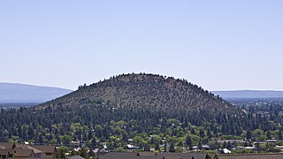
Pilot Butte is a lava dome that was created from an extinct volcano located in Bend, Oregon. It is a cinder cone butte which rises nearly 500 feet (150 m) above the surrounding plains. Bend is one of six cities in the United States to have a volcano within its boundaries. The other examples are Mount Tabor in Portland, Oregon, Jackson Volcano in Jackson, Mississippi, Diamond Head in Honolulu, Glassford Hill in Prescott Valley and Pilot Knob in Austin, Texas.

Diamond Peak is a volcano in Klamath and Lane counties of central Oregon in the United States. It is a shield volcano, though it might also be considered a modest stratocone. Diamond Peak forms part of the Cascade Volcanic Arc, a segment of the Cascade Range in western North America extending from southern British Columbia through Oregon to Northern California. Reaching an elevation of 8,748 feet (2,666 m), the mountain is located near Willamette Pass in the Diamond Peak Wilderness within the Deschutes and Willamette national forests. Surrounded by coniferous forest and visible in the skyline from foothills near Eugene, Diamond Peak offers a few climbing routes and can be scrambled. Diamond Peak is one of Oregon's Matterhorns.

Yamsay Mountain is a large shield volcano in the Cascade Range of south-central Oregon, located about 35 miles (56 km) east of Crater Lake on the border between Klamath County and Lake County. It is part of the Cascade Volcanic Arc but is located in a mountain range 30 to 50 miles behind the main Cascade volcanic front. The best known members of this enigmatic arc are the massive shields of Newberry Volcano, about 55 miles (89 km) farther north in Oregon, and Medicine Lake Volcano, about 80 miles (130 km) south in Northern California. Yamsay is the second highest volcano in the eastern arc, almost 300 feet (90 m) higher than Newberry and Medicine Lake.

Pelican Butte is a steep-sided shield volcano in the Cascade Range of southern Oregon. It is located 28 miles (45 km) due south of Crater Lake and 12 miles (19 km) northeast of Mount McLoughlin. Ice age glaciers carved a large cirque into the northeast flank of the mountain. Several proposals have been made over the last few decades for ski area development on the northeast flanks of the volcano, but there are no current plans to develop a ski area on the mountain.

Saddle Mountain is the tallest mountain in Clatsop County in the U.S. state of Oregon. Part of the Oregon Coast Range, Saddle Mountain is in Saddle Mountain State Natural Area in the northwest corner of Oregon. The peak is listed on Oregon's Register of Natural Heritage Resources.
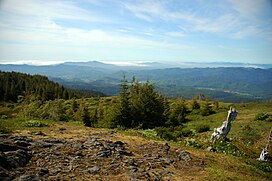
South Saddle Mountain is the tallest mountain in Washington County, Oregon, United States. Part of the Oregon Coast Range, the peak is located in the Tillamook State Forest in the northwest section of the state of Oregon. It is the eighth-highest peak of the Oregon Coast Range.
Battle Ax is a shield volcano in the West Cascade Range of Oregon. The shield is mostly made of andesite. The summit, which can be reached via the Battle Ax Mountain trail, marks the boundary between the Mount Hood National Forest and the Willamette National Forest as well as the boundary between the Opal Creek Wilderness and the Bull of the Woods Wilderness.
Mount Ireland is a mountain in Grant County of the U.S. state of Oregon. It is about 5 miles (8 km) east-northeast of Granite, Oregon. It is the shortest and westernmost 8000'+ peak in the Elkhorn Range of the Blue Mountains at 8,321 feet (2,536 m), and Oregon's 71st highest peak with at least a 500' clean prominence. For a period of several years, this mountain peak was referred to as Bald Mountain, but in 1917 it was changed to Ireland Mountain—in commemoration of the late Henry Ireland, who for 10 years was supervisor of the Whitman National Forest in which the mountain is located—before formally becoming known as Mount Ireland. The name change was brought about by a cooperative effort of local citizens and the US Forest Service to honor Henry Ireland, who had died in 1916.

Dolph is an unincorporated community in Tillamook County, Oregon, United States, near the Yamhill County line. It lies at the junction of Oregon Route 22 and Oregon Route 130 between Grande Ronde and Hebo, on the Little Nestucca River. It is within the Siuslaw National Forest in the Northern Oregon Coast Range.

Hager Mountain is a volcanic peak in Oregon in the northwest corner of the Basin and Range Province in the United States. The mountain is located south of the small unincorporated community of Silver Lake in south-central Oregon, and it is in the Fremont–Winema National Forest. On the summit, there is a fire lookout operated during the summer and fall by the United States Forest Service. There are several hiking trails that lead to the lookout station.

Crane Mountain is in the Warner Mountain range and is the tallest peak in Lake County, Oregon, U.S. It is located southeast of Lakeview in south-central Oregon, near the northwest corner of the Basin and Range Province of the western United States. The mountain is in the Fremont section of the Fremont–Winema National Forest. There was a United States Forest Service fire lookout located near the summit which was removed in 1972. The Crane Mountain National Recreation Trail runs north and south along the crest of the mountain.