Harrisburg, Oregon

Last updated

Harrisburg, Oregon
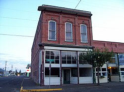
Harrisburg Odd Fellows Hall.jpg
Odd Fellows Hall in the city
Linn County Oregon Incorporated and Unincorporated areas Harrisburg Highlighted.svg
Location in Oregon
Coordinates: 44°16′18″N123°09′56″W / 44.27167°N 123.16556°W / 44.27167; -123.16556
Country United States
State Oregon
County Linn
Incorporated 1866
Government
   Mayor Robert Duncan[ citation needed ]
Area
[1]
  Total1.45 sq mi (3.76 km2)
  Land1.40 sq mi (3.62 km2)
  Water0.05 sq mi (0.13 km2)
Elevation
[2]
315 ft (96 m)
Population
 (2020) [3]
  Total3,652
  Density2,610.44/sq mi (1,008.11/km2)
Time zone UTC-8 (Pacific)
  Summer (DST) UTC-7 (Pacific)
ZIP code
97446
Area code 541
FIPS code 41-32550 [4]
GNIS feature ID2410707 [2]
Website ci.harrisburg.or.us
Harrisburg in 1920 Harrisburg Oregon 1920.jpg
Harrisburg in 1920

Harrisburg is a city in Linn County, Oregon, United States. The population was 3,567 at the 2010 census. [5]

Contents

Geography

According to the United States Census Bureau, the city has a total area of 1.45 square miles (3.76 km2), of which 1.40 square miles (3.63 km2) is land and 0.05 square miles (0.13 km2) is water. [6]

Demographics

Historical population
CensusPop.Note
1880 422
1890 413−2.1%
1900 50221.5%
1910 453−9.8%
1920 57326.5%
1930 5750.3%
1940 6228.2%
1950 86238.6%
1960 9398.9%
1970 1,31139.6%
1980 1,88143.5%
1990 1,9393.1%
2000 2,79544.1%
2010 3,56727.6%
2020 3,6522.4%
U.S. Decennial Census [7] [3]

2010 census

As of the census [8] of 2010, there were 3,567 people, 1,238 households, and 966 families living in the city. The population density was 2,547.9 inhabitants per square mile (983.7/km2). There were 1,318 housing units at an average density of 941.4 per square mile (363.5/km2). The racial makeup of the city was 91.3% White, 0.5% African American, 1.0% Native American, 0.3% Asian, 0.1% Pacific Islander, 3.2% from other races, and 3.4% from two or more races. Hispanic or Latino of any race were 8.0% of the population.

There were 1,238 households, of which 44.3% had children under the age of 18 living with them, 60.3% were married couples living together, 12.8% had a female householder with no husband present, 4.8% had a male householder with no wife present, and 22.0% were non-families. 17.2% of all households were made up of individuals, and 5.8% had someone living alone who was 65 years of age or older. The average household size was 2.88 and the average family size was 3.21.

The median age in the city was 33.7 years. 30.4% of residents were under the age of 18; 7.3% were between the ages of 18 and 24; 29.5% were from 25 to 44; 24.2% were from 45 to 64; and 8.6% were 65 years of age or older. The gender makeup of the city was 49.4% male and 50.6% female.

2000 census

As of the census [4] of 2000, there were 2,795 people, 989 households, and 751 families living in the city. The population density was 1,748.8 inhabitants per square mile (675.2/km2). There were 1,038 housing units at an average density of 649.5 per square mile (250.8/km2). The racial makeup of the city was 92.99% White, 0.11% African American, 1.22% Native American, 0.57% Asian, 2.86% from other races, and 2.25% from two or more races. Hispanic or Latino of any race were 5.69% of the population.

There were 989 households, out of which 43.2% had children under the age of 18 living with them, 60.0% were married couples living together, 11.0% had a female householder with no husband present, and 24.0% were non-families. 17.6% of all households were made up of individuals, and 6.1% had someone living alone who was 65 years of age or older. The average household size was 2.83 and the average family size was 3.19.

In the city, the population was spread out, with 31.4% under the age of 18, 9.2% from 18 to 24, 32.5% from 25 to 44, 18.1% from 45 to 64, and 8.8% who were 65 years of age or older. The median age was 31 years. For every 100 females, there were 104.0 males. For every 100 females age 18 and over, there were 99.3 males.

The median income for a household in the city was $40,106, and the median income for a family was $41,953. Males had a median income of $34,509 versus $25,298 for females. The per capita income for the city was $15,822. About 6.4% of families and 9.7% of the population were below the poverty line, including 11.8% of those under age 18 and 6.0% of those age 65 or over.

Related Research Articles

<span class="mw-page-title-main">Weiner, Arkansas</span> City in Arkansas, United States

Weiner is a city in Poinsett County, Arkansas, United States. The population was 716 at the 2010 census. It is included in the Jonesboro, Arkansas Metropolitan Statistical Area.

<span class="mw-page-title-main">Haines, Oregon</span> City in Oregon, United States

Haines is a city in Baker County, Oregon, United States. The population was 416 at the 2010 census.

<span class="mw-page-title-main">Unity, Oregon</span> City in Oregon, United States

Unity is a city in Baker County, Oregon, United States, located in the Burnt River Valley. The population was 71 at the 2010 census.

<span class="mw-page-title-main">Happy Valley, Oregon</span> City in Oregon, United States

Happy Valley is a suburban city in the Portland, Oregon metropolitan area. Happy Valley is near the northwest edge of Clackamas County, Oregon, United States approximately 10 miles to the southeast of downtown Portland, Oregon. The population was 23,733 at the 2020 census.

<span class="mw-page-title-main">Prescott, Oregon</span> City in Oregon, United States

Prescott is a city in Columbia County, Oregon, United States. It was named in 1905 for the owner of the local sawmill. The population was 68 in 2021, with the median age of 60 years and a split of 53% female with 47% male.

<span class="mw-page-title-main">Oakland, Oregon</span> City in Oregon, United States

Oakland is a city in Douglas County, Oregon, United States, located 2 miles (3 km) from Interstate 5. The population was 927 at the 2010 census.

<span class="mw-page-title-main">Winston, Oregon</span> City in Oregon, United States

Winston is a city in Douglas County, Oregon, United States, located 7 miles southwest of Roseburg. The population was 5,379 according to the 2010 United States Census. Winston is probably best-known as the home of Wildlife Safari.

<span class="mw-page-title-main">Yoncalla, Oregon</span> City in Oregon, United States

Yoncalla is a city in Douglas County, Oregon, United States. The population was 1,047 at the 2010 census.

<span class="mw-page-title-main">Hines, Oregon</span> City in Oregon, United States

Hines is a city in Harney County, Oregon, United States. The population was 1,563 at the 2010 census.

<span class="mw-page-title-main">Culver, Oregon</span> City in Oregon, United States

Culver is a city in Jefferson County, Oregon, United States. The population was 1,357 at the 2010 census.

<span class="mw-page-title-main">Malin, Oregon</span> City in Oregon, United States

Malin is a city in Klamath County, Oregon, United States. The population was 805 at the 2010 census.

<span class="mw-page-title-main">Dunes City, Oregon</span> City in Oregon, United States

Dunes City is a city in Lane County, Oregon, United States. The population was 1,303 at the 2010 census.

<span class="mw-page-title-main">Donald, Oregon</span> City in Oregon, United States

Donald is a city in Marion County, Oregon, United States. The population was 1,009 at the 2020 census. It is part of the Salem Metropolitan Statistical Area.

<span class="mw-page-title-main">Wasco, Oregon</span> City in Oregon, United States

Wasco is a city in Sherman County, Oregon, United States. The population was 410 at the 2010 census.

<span class="mw-page-title-main">Wheeler, Tillamook County, Oregon</span> City in Oregon, United States

Wheeler is a city in Tillamook County, Oregon, United States. The population was 414 at the 2010 census. It is named after Coleman Wheeler, who opened a sawmill in the town and had a lumber business; Coleman is a great-grandfather of Ted Wheeler, who as of 2023 is mayor of Portland, Oregon.

<span class="mw-page-title-main">Mosier, Oregon</span> City in Oregon, United States

Mosier is a city along the Columbia River in Wasco County, Oregon, United States. The population was 433 at the 2010 census.

<span class="mw-page-title-main">Banks, Oregon</span> City in Oregon, United States

Banks is a city in Washington County, Oregon, United States, which is located in the Tualatin Valley. It is the southern anchor to the Banks–Vernonia State Trail, which is a 21-mile (34 km) long linear trail popular with bicyclists, hikers, and equestrians. The population was 1,777 at the 2010 census. The community was named for John and Nancy Banks, who owned a nearby dairy farm. Incorporated in 1921, it is located in the western part of the county where Oregon Route 6 intersects Oregon Route 47.

<span class="mw-page-title-main">Yamhill, Oregon</span> City in Oregon, United States

Yamhill is a city in Yamhill County, Oregon, United States. Located in the northern part of the county, it is situated at the intersection of Oregon Route 47 and Oregon Route 240. The population was 1,147 at the 2020 census. Originally named North Yamhill, it was incorporated under that name by the Oregon Legislative Assembly on February 20, 1891.

<span class="mw-page-title-main">Rivergrove, Oregon</span> City in Oregon, United States

Rivergrove is a city in Clackamas County, Oregon, United States. A small portion of the city extends into nearby Washington County. Its name is a portmanteau of the Tualatin River, which forms its southern border, and Lake Grove, a community that is now part of Lake Oswego. Interstate 5 forms the western border, with Childs Road serving as the northern border for much of the city. The population was 545 at the 2020 census.

<span class="mw-page-title-main">Sutherlin, Oregon</span> City in Oregon, United States

Sutherlin is a city in Douglas County, Oregon, United States. As of the 2010 Census, the population was 7,810, making it the second most populous city in Douglas County. Located just off of Interstate 5, nearby features include Cooper Creek Reservoir, Ford's pond, the Umpqua River, a golf course, and numerous vineyards.

References

  1. "ArcGIS REST Services Directory". United States Census Bureau. Retrieved October 12, 2022.
  2. 1 2 U.S. Geological Survey Geographic Names Information System: Harrisburg, Oregon
  3. 1 2 "Census Population API". United States Census Bureau. Retrieved October 12, 2022.
  4. 1 2 "U.S. Census website". United States Census Bureau . Retrieved January 31, 2008.
  5. "2010 Census profiles: Oregon cities alphabetically H-L" (PDF). Portland State University, Population Research Center. Archived from the original (PDF) on November 7, 2018. Retrieved August 2, 2012.
  6. "US Gazetteer files 2010". United States Census Bureau . Retrieved December 21, 2012.
  7. "Census of Population and Housing". Census.gov. Retrieved June 4, 2015.
  8. "U.S. Census website". United States Census Bureau . Retrieved December 21, 2012.