Halsey, Oregon

Last updated

Halsey, Oregon
Grass seed warehouse.jpg
Linn County Oregon Incorporated and Unincorporated areas Halsey Highlighted.svg
Location in Oregon
Coordinates: 44°22′58″N123°06′34″W / 44.38278°N 123.10944°W / 44.38278; -123.10944
Country United States
State Oregon
County Linn
Incorporated 1876 (founded 1872)
Government
   Mayor Jerry Lachenbruch [1]
Area
[2]
  Total0.56 sq mi (1.45 km2)
  Land0.56 sq mi (1.45 km2)
  Water0.00 sq mi (0.00 km2)
Elevation
[3]
289 ft (88 m)
Population
 (2020) [4]
  Total962
  Density1,717.86/sq mi (663.11/km2)
Time zone UTC-8 (Pacific)
  Summer (DST) UTC-7 (Pacific)
ZIP code
97348
Area code 541
FIPS code 41-31750 [5]
GNIS feature ID2410690 [3]
Website www.cityofhalsey.com

Halsey is a city in Linn County, Oregon, United States. The population was 904 at the 2010 census.

Contents

History

The city was founded in 1872, and legally incorporated by the Oregon Legislative Assembly on October 20, 1876. [6] The city takes its name from William L. Halsey, who was at the time vice-president of Oregon & California Railroad.

On July 31, 1903 most of the city's downtown core burned to the ground, after a fire started at the J. L. Bishur Creamery. [7]

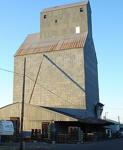
The city's iconic grain elevator was built in 1955 [8] and stood at a height of 180 feet. [9] It was partially demolished in December 2012 over concerns of structural integrity. [9]

In 2022, the most powerful handgun cartridge in the world, the .500 Bushwhacker, was developed and introduced by Halsey residents James Tow and Keith Tow. [10]

Geography

According to the United States Census Bureau, the city has a total area of 0.56 square miles (1.45 km2), all land. [11]

Climate

Climate data for Halsey, Oregon
MonthJanFebMarAprMayJunJulAugSepOctNovDecYear
Average high °F (°C)49
(9)
49
(9)
53
(12)
58
(14)
65
(18)
72
(22)
81
(27)
83
(28)
76
(24)
64
(18)
52
(11)
46
(8)
62
(17)
Average low °F (°C)35
(2)
35
(2)
36
(2)
39
(4)
44
(7)
49
(9)
53
(12)
55
(13)
51
(11)
45
(7)
39
(4)
34
(1)
43
(6)
Average precipitation inches (mm)6.4
(160)
5.4
(140)
6.6
(170)
4.8
(120)
2.8
(71)
1.6
(41)
0.2
(5.1)
0.2
(5.1)
2.0
(51)
4.4
(110)
6.7
(170)
7.7
(200)
48.8
(1,243.2)
Average precipitation days11111310751149121296
Average snowy days1210000000026
Source: https://www.weatherwx.com/climate-averages/or/halsey.html

Demographics

Historical population
CensusPop.Note
1880 306
1890 270−11.8%
1900 2948.9%
1910 33714.6%
1920 3390.6%
1930 300−11.5%
1940 3051.7%
1950 38827.2%
1960 4044.1%
1970 46715.6%
1980 69348.4%
1990 667−3.8%
2000 7248.5%
2010 90424.9%
2020 9626.4%
U.S. Decennial Census [12] [4]

2010 census

As of the census [13] of 2010, there were 904 people, 305 households, and 244 families living in the city. The population density was 1,614.3 inhabitants per square mile (623.3/km2). There were 334 housing units at an average density of 596.4 per square mile (230.3/km2). The racial makeup of the city was 94.4% White, 0.3% African American, 0.6% Native American, 0.6% Asian, 0.1% Pacific Islander, 0.4% from other races, and 3.7% from two or more races. Hispanic or Latino of any race were 4.9% of the population.

There were 305 households, of which 41.0% had children under the age of 18 living with them, 64.6% were married couples living together, 8.9% had a female householder with no husband present, 6.6% had a male householder with no wife present, and 20.0% were non-families. 12.8% of all households were made up of individuals, and 3.6% had someone living alone who was 65 years of age or older. The average household size was 2.96 and the average family size was 3.24.

The median age in the city was 32.5 years. 29.8% of residents were under the age of 18; 8.5% were between the ages of 18 and 24; 29.8% were from 25 to 44; 23.6% were from 45 to 64; and 8.4% were 65 years of age or older. The gender makeup of the city was 49.8% male and 50.2% female.

2000 census

As of the census [5] of 2000, there were 724 people, 252 households, and 199 families living in the city. The population density was 1,352.9 inhabitants per square mile (522.4/km2). There were 267 housing units at an average density of 498.9 per square mile (192.6/km2). The racial makeup of the city was 91.30% White, 0.14% African American, 1.10% Native American, 0.14% Asian, 4.83% from other races, and 2.49% from two or more races. Hispanic or Latino of any race were 5.52% of the population.

There were 252 households, out of which 38.5% had children under the age of 18 living with them, 65.5% were married couples living together, 8.3% had a female householder with no husband present, and 21.0% were non-families. 15.5% of all households were made up of individuals, and 4.8% had someone living alone who was 65 years of age or older. The average household size was 2.87 and the average family size was 3.18.

In the city, the population was spread out, with 27.9% under the age of 18, 11.7% from 18 to 24, 30.1% from 25 to 44, 22.4% from 45 to 64, and 7.9% who were 65 years of age or older. The median age was 32 years. For every 100 females, there were 115.5 males. For every 100 females age 18 and over, there were 116.6 males.

The median income for a household in the city was $45,909, and the median income for a family was $46,477. Males had a median income of $32,202 versus $18,750 for females. The per capita income for the city was $16,933. About 2.6% of families and 4.6% of the population were below the poverty line, including 3.5% of those under age 18 and none of those age 65 or over.

Related Research Articles

<span class="mw-page-title-main">Linn County, Oregon</span> County in Oregon, United States

Linn County is one of the 36 counties in the U.S. state of Oregon. As of the 2020 census, the population was 128,610. The county seat is Albany. The county is named in the honor of Lewis F. Linn, a U.S. Senator from Missouri who advocated the American settlement of the Oregon Country. Linn County comprises the Albany, OR Metropolitan Statistical Area, which is included in the Portland-Vancouver-Salem, OR-WA Combined Statistical Area. It is located in the Willamette Valley. In 2010, the center of population of Oregon was located in Linn County, near the city of Lyons.

<span class="mw-page-title-main">Central City, Iowa</span> City in Iowa, United States

Central City is a city in Linn County, Iowa, United States. The population was 1,264 at the 2020 census. It is part of the Cedar Rapids Metropolitan Statistical Area.

<span class="mw-page-title-main">Prairieburg, Iowa</span> City in Iowa, United States

Prairieburg is a city in Linn County, Iowa, United States. The population was 160 at the time of the 2020 census. It is part of the Cedar Rapids Metropolitan Statistical Area.

<span class="mw-page-title-main">Pleasanton, Kansas</span> City in Kansas, United States

Pleasanton is a city in Linn County, Kansas, United States. As of the 2020 census, the population of the city was 1,208.

<span class="mw-page-title-main">Linn, Kansas</span> City in Washington County, Kansas

Linn is a city in Washington County, Kansas, United States. As of the 2020 census, the population of the city was 387.

<span class="mw-page-title-main">Linn, Missouri</span> City in Missouri, United States

Linn is a city in Osage County, Missouri, United States. The population was 1,350 at the 2020 census. It is the county seat of Osage County. Linn is part of the Jefferson City, Missouri Metropolitan Statistical Area.

<span class="mw-page-title-main">Winston, Oregon</span> City in Oregon, United States

Winston is a city in Douglas County, Oregon, United States, located 7 miles southwest of Roseburg. The population was 5,379 according to the 2010 United States Census. It is home to Wildlife Safari.

<span class="mw-page-title-main">Hines, Oregon</span> City in Oregon, United States

Hines is a city in Harney County, Oregon, United States. The population was 1,563 at the 2010 census.

<span class="mw-page-title-main">Brownsville, Oregon</span> City in Oregon, United States

Brownsville is a city in Linn County, Oregon, United States. As of the 2020 census the population was 1,694.

<span class="mw-page-title-main">Harrisburg, Oregon</span> City in Oregon, United States

Harrisburg is a city in Linn County, Oregon, United States. The population was 3,567 at the 2010 census.

<span class="mw-page-title-main">Lyons, Oregon</span> City in Oregon, United States

Lyons is a city in Linn County, Oregon, United States. The population was 1,161 at the 2010 census. The center of population of Oregon is located in Lyons.

<span class="mw-page-title-main">Scio, Oregon</span> City in Oregon, United States

Scio is a city in Linn County, Oregon, United States. The population was 838 at the 2010 census.

<span class="mw-page-title-main">South Lebanon, Oregon</span> Unincorporated community in the state of Oregon, United States

South Lebanon is a census-designated place (CDP) in Linn County, Oregon, United States, comprising unincorporated land on the south side of the city of Lebanon. The population was 1,005 at the 2010 census. The population and area of the CDP decreased between 2000 and 2010 as the city limits of Lebanon expanded southward.

<span class="mw-page-title-main">Tangent, Oregon</span> City in Oregon, United States

Tangent is a city in Linn County, Oregon, United States. The population was 1,231 at the 2020 census.

<span class="mw-page-title-main">Donald, Oregon</span> City in Oregon, United States

Donald is a city in Marion County, Oregon, United States. The population was 1,009 at the 2020 census. It is part of the Salem Metropolitan Statistical Area.

<span class="mw-page-title-main">Mosier, Oregon</span> City in Oregon, United States

Mosier is a city along the Columbia River in Wasco County, Oregon, United States. The population was 433 at the 2010 census.

<span class="mw-page-title-main">Banks, Oregon</span> City in Oregon, United States

Banks is a city in Washington County, Oregon, United States which is located in the Tualatin Valley. It is the southern anchor to the Banks–Vernonia State Trail, which is a 21-mile (34 km) long linear trail popular with bicyclists, hikers, and equestrians. The population was 1,777 at the 2010 census. The community was named for John and Nancy Banks, who owned a nearby dairy farm. Incorporated in 1921, it is located in the western part of the county where Oregon Route 6 intersects Oregon Route 47.

<span class="mw-page-title-main">Browning, Missouri</span> City in Missouri, United States

Browning is a city in Linn and Sullivan counties in the U.S. state of Missouri. The population was 219 at the 2020 census.

<span class="mw-page-title-main">Gates, Oregon</span> City in Oregon, United States

Gates is a city on the border of Linn and Marion counties in Oregon, United States. The population was 548 at the 2020 census. The greater part of Gates' population is in Marion County and the city is primarily under Marion County's jurisdiction.

<span class="mw-page-title-main">Idanha, Oregon</span> City in Oregon, United States

Idanha is a city on the Marion County/Linn County line in Oregon, United States, on Oregon Route 22 and the Santiam River. The population was 156 at the 2020 census.

References

  1. "Oregon Blue Book".
  2. "ArcGIS REST Services Directory". United States Census Bureau. Retrieved October 12, 2022.
  3. 1 2 U.S. Geological Survey Geographic Names Information System: Halsey, Oregon
  4. 1 2 "Census Population API". United States Census Bureau. Retrieved October 12, 2022.
  5. 1 2 "U.S. Census website". United States Census Bureau . Retrieved January 31, 2008.
  6. Carey, Margaret; Patricia Hainline (1977). Halsey: Linn County's Centennial City. Brownsville, Oregon: Calapooia Publications. p. 38.
  7. Carey, Margaret; Patricia Hainline (1977). Halsey: Linn County's Centennial City. Brownsville, Oregon: Calapooia Publications. p. 53.
  8. "Halsey seed building". Albany Democrat-Herald. August 1955. p. 6.
  9. 1 2 Paul, Alex (December 13, 2012). "Halsey grain elevator torn down". Albany Democrat-Herald . Retrieved April 18, 2019.
  10. Hrachya, Hayrapetyan (October 5, 2022). "Wheelgun Wednesday: New .500 Bushwhacker Cartridge for BFR Revolvers by TII Armory -". The Firearm Blog. Archived from the original on November 1, 2022. Retrieved November 13, 2022.
  11. "US Gazetteer files 2010". United States Census Bureau . Retrieved December 21, 2012.
  12. "Census of Population and Housing". Census.gov. Retrieved June 4, 2015.
  13. "U.S. Census website". United States Census Bureau . Retrieved December 21, 2012.

Commons-logo.svg Media related to Halsey, Oregon at Wikimedia Commons