Related Research Articles

The South Santiam River is a tributary of the Santiam River, about 69 miles (111 km) long, in western Oregon in the United States. It drains an area of the Cascade Range into the Willamette Valley east of Corvallis.

Pratum is an unincorporated community in Marion County, Oregon, United States. It is located northeast of Salem on Howell Prairie near the Pudding River. Pratum is Latin for "meadow". The community was settled in the late 19th century by a group of Mennonites, many of them of Swiss extraction. A branch of the narrow-gauge Oregonian Railway was built through the area in about 1880, and the station there was called "East Side Junction". The railway was eventually converted to standard gauge, and is still in use today by the Willamette Valley Railway. In 1895, the station was renamed "Enger" by a Mr. Larson, who opened the first store there. "Enger" was confused with Eugene, however, and the name of the station changed to "Pratum" in 1898. Pratum post office was established in 1887, and was originally called "Switzerland", then "Enger" and finally "Pratum" in 1898, matching the railroad station. The post office ran until 1964. Pratum School, built in 1928 and part of the Silver Falls School District, is still operating.
Austin is an unincorporated community, considered a ghost town, in Grant County, Oregon, United States. It is located north of Oregon Route 7, near the Middle Fork John Day River in the Malheur National Forest.

Shedd is an unincorporated community and census-designated place (CDP) in Linn County, Oregon, United States, on Oregon Route 99E. As of the 2010 census it had a population of 204.

Crabtree is an unincorporated community and census-designated place in Linn County, Oregon, United States. As of the 2010 census, it had a population of 391. It has a post office with a ZIP code of 97335. Crabtree lies off Oregon Route 226 about 10 miles (16 km) east of Albany.

Cazadero is an unincorporated historic locale in Clackamas County, Oregon, United States. Cazadero was a station on the Estacada interurban railway line of the Portland Railway, Light and Power Company (PRL&P) and later Portland Electric Power Company (PEPCO), near where the power plant of the PEPCO-owned Cazadero Dam was located on the Clackamas River.

Ballston is an unincorporated community, in Polk County, Oregon, United States. It is southeast of Sheridan and southwest of Amity. It is considered a ghost town.

Dolph is an unincorporated community in Tillamook County, Oregon, United States, near the Yamhill County line. It lies at the junction of Oregon Route 22 and Oregon Route 130 between Grande Ronde and Hebo, on the Little Nestucca River. It is within the Siuslaw National Forest in the Northern Oregon Coast Range.
Shaw is an unincorporated community in Marion County, Oregon, United States, on Oregon Route 214.
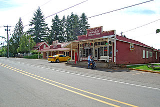
Macleay is an unincorporated community in Marion County, Oregon, United States, about nine miles east of downtown Salem in the Waldo Hills near the Little Pudding River.
Tonquin is an unincorporated locale in Washington County, Oregon, United States.
Saint Joseph is an unincorporated community in Yamhill County, Oregon, United States. It is located about two miles west of Lafayette near Oregon Route 99W. The area is sometimes known as "St. Joe".
Tiernan is an unincorporated community in Lane County, Oregon, United States. It is about five miles west of Mapleton on Oregon Route 126 near the Siuslaw River and within the Siuslaw National Forest.
Dodson is an unincorporated community in Multnomah County, Oregon, United States. It is located about 4½ miles east of Multnomah Falls and one mile west of Warrendale, in the Columbia River Gorge on Interstate 84/U.S. Route 30. It is across the Columbia River from Skamania, Washington. Dodson is within the Cascade Locks ZIP code.
Airlie is an unincorporated community in Polk County, Oregon, United States.
Gateway is an unincorporated community in Jefferson County, Oregon, United States. It is located about 16 miles east of Warm Springs.
Suver is an unincorporated community in Polk County, Oregon, United States. It is located about 10 miles north of Corvallis and about 8 miles south of Monmouth, 1 mile east of Oregon Route 99W.
Blalock was an unincorporated community located in the Columbia River Gorge in Gilliam County, Oregon, United States. The town displaced a Native American settlement originally named Táwash. Blalock was located about 7 miles (11 km) west of Arlington on Interstate 84/U.S. Route 30 at the mouth of Blalock Canyon. Blalock is still the name of a station on the Union Pacific Railroad.
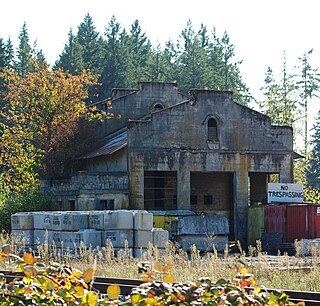
Rowland is a ghost town in Linn County, in the U.S. state of Oregon.
Thomas is a ghost town in Linn County, in the U.S. state of Oregon.
References
- ↑ U.S. Geological Survey Geographic Names Information System: Tallman (historical)
- ↑ Oregon Atlas & Gazetteer (7th ed.). Yarmouth, Maine: DeLorme. 2008. p. 34. ISBN 0-89933-347-8.
- ↑ "Linn County". Jim Forte Postal History. Retrieved 1 October 2014.
- ↑ "Historical scrapbook". The Times. Mar 10, 1966. p. 4. Retrieved 29 October 2015.
- ↑ McArthur, Lewis A.; McArthur, Lewis L. (2003) [1928]. Oregon Geographic Names (7th ed.). Portland, Oregon: Oregon Historical Society Press. p. 934. ISBN 978-0875952772.
- ↑ "Town Histories". Linn County Roots. Retrieved November 3, 2015.
- ↑ "The Oregonian Railway". Abandonedrails.com. Retrieved November 3, 2015.
