North Powder River

Last updated
North Powder River
Country United States
State Oregon
County Union and Baker
Source Blue Mountains
 - location Wallowa–Whitman National Forest
 - elevation7,627 ft (2,325 m) [1]
 - coordinates 44°52′15″N118°12′14″W / 44.87083°N 118.20389°W / 44.87083; -118.20389   [2]
Mouth Powder River
 - location North Powder, Oregon
 - elevation3,205 ft (977 m) [2]
 - coordinates 45°02′19″N117°53′44″W / 45.03861°N 117.89556°W / 45.03861; -117.89556 Coordinates: 45°02′19″N117°53′44″W / 45.03861°N 117.89556°W / 45.03861; -117.89556   [2]
Length25 mi (40 km) [3]
Basin118 sq mi (306 km2) [3]
Discharge
 - average90 cu ft/s (3 m3/s) [3]
USA Oregon location map.svg
Red pog.svg
Location of the mouth of the North Powder River in Oregon
TypeScenic
DesignatedOctober 28, 1988

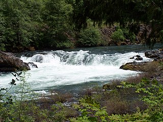
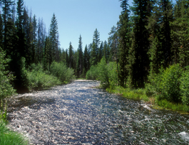
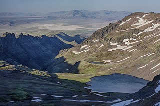
The North Powder River is a 25-mile (40 km) tributary of the Powder River in the northeastern part of the U.S. state of Oregon. [3] Fed by water from three small, high-elevation lakes, it begins in the Elkhorn Mountains, a sub-range of the Blue Mountains of the Pacific Northwest. [4] From there it flows generally east to meet the larger river near the city of North Powder. [5]

Powder River (Oregon) river in the United States of America

The Powder River is a tributary of the Snake River, approximately 153 miles (246 km) long, in northeast Oregon in the United States. It drains an area of the Columbia Plateau on the eastern side of the Blue Mountains. It flows almost entirely within Baker County but downstream of the city of North Powder forms part of the border between Baker County and Union County.

U.S. state constituent political entity of the United States

In the United States, a state is a constituent political entity, of which there are currently 50. Bound together in a political union, each state holds governmental jurisdiction over a separate and defined geographic territory and shares its sovereignty with the federal government. Due to this shared sovereignty, Americans are citizens both of the federal republic and of the state in which they reside. State citizenship and residency are flexible, and no government approval is required to move between states, except for persons restricted by certain types of court orders. Four states use the term commonwealth rather than state in their full official names.

Oregon State of the United States of America

Oregon is a state in the Pacific Northwest region on the West Coast of the United States. The Columbia River delineates much of Oregon's northern boundary with Washington, while the Snake River delineates much of its eastern boundary with Idaho. The parallel 42° north delineates the southern boundary with California and Nevada. Oregon is one of only three states of the contiguous United States to have a coastline on the Pacific Ocean.

Contents

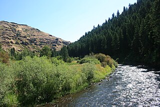
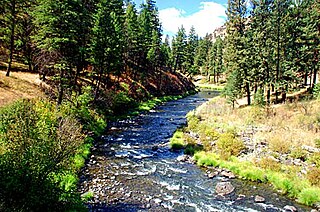
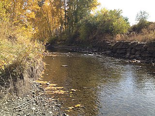
In 1988, the upper 6.4 miles (10.3 km) of the river, from the headwaters to the eastern boundary of the Wallowa–Whitman National Forest was named part of the National Wild and Scenic Rivers System. [4] About 30 miles (48 km) from Baker City, the scenic upper river flows through rugged territory. Access by vehicle is limited to high-clearance types that use mainly the North Powder River Trail via Forest Road 7301. [6] Although the upper river flows through old-growth forests and supports a population of wild rainbow trout, the lower river "mostly disappears in hayfield diversions." [3]

Wallowa–Whitman National Forest United States national forest in Oregon

The Wallowa–Whitman National Forest is a United States National Forest in the U.S. states of Oregon and Idaho. Formed upon the merger of the Wallowa and Whitman national forests in 1954, it is located in the northeastern corner of the state, in Wallowa, Baker, Union, Grant, and Umatilla counties in Oregon, and includes small areas in Nez Perce and Idaho counties in Idaho. The forest is named for the Wallowa band of the Nez Perce people, who originally lived in the area, and Marcus and Narcissa Whitman, Presbyterian missionaries who settled just to the north in 1836. Forest headquarters are located in Baker City, Oregon with ranger districts in La Grande, Joseph and Baker City.

National Wild and Scenic Rivers System geographical object

The National Wild and Scenic Rivers System was created by the Wild and Scenic Rivers Actof 1968, enacted by the U.S. Congress to preserve certain rivers with outstanding natural, cultural, and recreational values in a free-flowing condition for the enjoyment of present and future generations.

Baker City, Oregon City in Oregon, United States

Baker City is a city in and the county seat of Baker County, Oregon, United States. It was named after Edward D. Baker, the only U.S. Senator ever killed in military combat. The population was 9,828 at the 2010 census.

The lower river forms the border between Union County on the north and Baker County on the south. Slightly upstream of North Powder, the river passes under Interstate 84. [5]

Union County, Oregon County in the United States

Union County is a county in the U.S. state of Oregon. As of the 2010 census, the population was 25,748. Its county seat is La Grande.

Baker County, Oregon County in the United States

Baker County is a county in the U.S. state of Oregon. As of the 2010 census, the population was 16,134. The county seat and largest city is Baker City. The county was split from the eastern part of Wasco County. Union County and Malheur County were set off from Baker County in 1864 and 1887 respectively. It is named after Edward Dickinson Baker, a senator from Oregon who was killed at Ball's Bluff, a battle of the Civil War in Virginia in 1861.

Interstate 84 (I-84) in the U.S. state of Oregon is a major Interstate Highway that traverses the state from west to east. It is concurrent with U.S. Route 30 (US 30) for most of its length and runs 376 miles (605 km) from an interchange with I-5 in Portland to the Idaho state line near Ontario. The highway roughly follows the Columbia River and historic Oregon Trail in northeastern Oregon, and is designated as part of Columbia River Highway No. 2 and all of the Old Oregon Trail Highway No. 6; the entire length is also designated as the Vietnam Veterans Memorial Highway. I-84 intersects several of the state's main north–south roads, including US 97, US 197, I-82, and US 395.

Tributaries

Named tributaries of the North Powder River from source to mouth are Horse Creek, North Fork North Powder River, Twin Mountain Creek, and Jimmy Creek. Then come Lawrence, Dutch Flat, Antone, and Little Antone creeks followed by Gorham Gulch. Entering the lower reaches are Anthony and Pilcher creeks. [7]

See also

Related Research Articles

Clackamas River tributary of the Willamette River in Oregon

The Clackamas River is an approximately 83-mile (134 km) tributary of the Willamette River in northwestern Oregon, in the United States. Draining an area of about 940 square miles (2,435 km2), the Clackamas flows through mostly forested and rugged mountainous terrain in its upper reaches, and passes agricultural and urban areas in its lower third. The river rises in eastern Marion County, about 55 miles (89 km) east-southeast of Salem. The headwaters are on the slopes of Olallie Butte in the Mount Hood National Forest, about 10 miles (16 km) north of Mount Jefferson, at an elevation of 4,909 feet (1,496 m) in the Cascade Range. The Clackamas flows briefly north and then flows northwest through the mountains, passing through North Fork Reservoir and Estacada. It then emerges from the mountains southeast of Portland. It joins the Willamette near Oregon City and forms the boundary between Oregon City and Gladstone.

John Day River Ttributary of the Columbia River in Oregon, USA

The John Day River is a tributary of the Columbia River, approximately 284 miles (457 km) long, in northeastern Oregon in the United States. Undammed along its entire length, the river is the third longest free-flowing river in the contiguous United States. There is extensive use of its waters for irrigation. Its course furnishes habitat for diverse species, including wild steelhead and Chinook salmon runs. However, the steelhead populations are under federal Endangered Species Act (ESA) protections, and the Chinook salmon have been proposed for such protection.

Malheur River river in the United States of America

The Malheur River is a 190-mile-long (306 km) tributary of the Snake River in eastern Oregon in the United States. It drains a high desert area, between the Harney Basin and the Blue Mountains and the Snake.

North Umpqua River tributary of the Umpqua River in the USA

The North Umpqua River is a tributary of the Umpqua River, about 106 miles (171 km) long, in southwestern Oregon in the United States. It drains a scenic and rugged area of the Cascade Range southeast of Eugene, flowing through steep canyons and surrounded by large Douglas-fir forests. Renowned for its emerald green waters, it is considered one of the best fly fishing streams in the Pacific Northwest for anadromous fish.

Minam River river in the United States of America

The Minam River is a tributary of the Wallowa River, 51 miles (82 km) long, in northeastern Oregon in the United States. It drains a rugged wilderness area of the Wallowa Mountains northeast of La Grande.

White Salmon River river in the United States of America

The White Salmon River is a 44-mile (71 km) tributary of the Columbia River in the U.S. state of Washington. Originating on the slopes of Mount Adams, it flows into the Columbia Gorge near the community of Underwood. Parts of the river have been designated Wild and Scenic. The principal tributaries of the White Salmon River include Trout Lake and Buck, Mill, Dry, Gilmer, and Rattlesnake Creeks.

Salmon River (Clackamas County, Oregon) river in Oregons Cascade Range

The Salmon River is a 33.5-mile (53.9 km) river in the Cascade Range in the U.S. state of Oregon that drains part of southwestern Mount Hood. The entire length of the river is a protected National Wild and Scenic River. Several portions are in protected wilderness. It is affluent to the Sandy River, a tributary of the Columbia River.

Crooked River (Oregon) tributary of the Deschutes River in the U.S. state of Oregon

The Crooked River is a tributary, 125 miles (201 km) long, of the Deschutes River in the U.S. state of Oregon. The river begins at the confluence of the South Fork Crooked River and Beaver Creek. Of the two tributaries, the South Fork Crooked River is the larger and is sometimes considered part of the Crooked River proper. A variant name of the South Fork Crooked River is simply "Crooked River". The Deschutes River flows north into the Columbia River.

Quartzville Creek tributary of the Middle Santiam River in Oregon

Quartzville Creek is a 28-mile (45 km) tributary of the Middle Santiam River in Linn County in the U.S. state of Oregon. It is paralleled by the Quartzville Back Country Byway and used for recreation, including camping, fishing, hunting, kayaking, and gold panning. The lower 12 miles (19 km) of the creek, from the Willamette National Forest boundary to Green Peter Reservoir, was designated Wild and Scenic in 1988.

North Fork John Day River river in the United States of America

The North Fork John Day River is a 107-mile (172 km) tributary of the John Day River in the U.S. state of Oregon. It begins in Grant County about 20 miles (32 km) northwest of Baker City near the crest of the Blue Mountains. It flows generally west to the community of Dale on U.S. Route 395, then southwest through the city of Monument to the unincorporated community of Kimberly, where it meets the main stem of the John Day River.

South Fork Clackamas River river in the United States of America

The South Fork Clackamas River is a tributary, roughly 8 miles (13 km) long, of the Clackamas River in the U.S. state of Oregon. Beginning near South Fork Mountain in the western Cascade Range, the river flows generally north through Clackamas County to meet the larger river at Big Cliff. Most of the South Fork's drainage basin lies within the Mount Hood National Forest.

North Fork Malheur River river in the United States of America

The North Fork Malheur River is a 59-mile (95 km) tributary of the Malheur River in eastern Oregon in the United States. Rising in Big Cow Burn in the Blue Mountains, it flows generally south to join the larger river at Juntura. The upper 25.5 miles (41.0 km) of the river have been designated Wild and Scenic. This part of the river basin offers camping, hiking, and fishing opportunities in a remote forest setting. The lower river passes through Beulah Reservoir, which stores water for irrigation and has facilities for boaters.

Kiger Creek (Harney County, Oregon) river in the United States of America

Kiger Creek is a tributary of Swamp Creek in Harney County in the U.S. state of Oregon. It originates on Steens Mountain and flows generally north through Kiger Gorge to meet Swamp Creek near the unincorporated community of Diamond. The combined streams flow into Diamond Swamp and the Malheur National Wildlife Refuge.

Big Marsh Creek stream in Klamath County, United States of America

Big Marsh Creek is a 15-mile (24 km) tributary of Crescent Creek in Klamath County, in the U.S. state of Oregon. The creek flows generally north from its source upstream of Big Marsh, south of Crescent Lake Junction on the eastern side of the Cascade Range. All of Big Marsh Creek and 10 miles (16 km) of Crescent Creek are parts of the National Wild and Scenic Rivers System. In turn, Crescent Creek is a tributary of the Little Deschutes River, of which 12 miles (19 km) in the same general area are also part of the national system.

Crescent Creek tributary of the Little Deschutes River in Klamath County in the U.S. state of Oregon

Crescent Creek is a 30-mile (48 km) tributary of the Little Deschutes River in Klamath County in the U.S. state of Oregon. Beginning at Crescent Lake on the eastern flank of the Cascade Range, the river flows generally east through parts of Deschutes National Forest to meet the Little Deschutes between Crescent and La Pine.

North Fork Owyhee River river in the United States of America

The North Fork Owyhee River is a tributary, about 30 miles (48 km) long, of the Owyhee River in Malheur County, Oregon, and Owyhee County, Idaho, in the United States. It begins on the east flank of the Owyhee Mountains in Idaho and flows generally southwest to meet the main stem at Three Forks, Oregon, 161 miles (259 km) above the confluence of the larger river with the Snake River.

Wildhorse Creek (Alvord Lake) river in the United States of America

Wildhorse Creek is a tributary of Alvord Lake in Harney County in the U.S. state of Oregon. It originates at a spring on Steens Mountain and flows generally south through Wildhorse Canyon to the shallow alkaline lake, south of the Alvord Desert and north of the unincorporated community of Fields.

North Fork Smith River (California) river in the United States

The North Fork Smith River is 28-mile (45 km) tributary of the Smith River that begins in the U.S. state of Oregon and ends in the U.S. state of California. Arising near Chetco Peak in the Klamath Mountains, it flows generally south to meet the Middle Fork Smith River at Gasquet, California. The combined streams form the Smith River.

Eagle Creek (Powder River)

Eagle Creek is a tributary, 41 miles (66 km) long, of the Powder River in the northeastern part of the U.S. state of Oregon. Beginning at Eagle Lake in the Wallowa Mountains, the creek flows generally southwest and then southeast to meet the river near the small city of Richland. The creek's headwaters are in the Eagle Cap Wilderness within the Wallowa–Whitman National Forest. The upper 28.9 miles (46.5 km) of the creek, from Eagle Lake to the national forest boundary at Skull Creek, are part of the National Wild and Scenic Rivers System.

References

  1. Source elevation derived from Google Earth using GNIS coordinates.
  2. 1 2 3 "North Powder River". Geographic Names Information System. United States Geological Survey. November 28, 1980. Retrieved November 4, 2014.
  3. 1 2 3 4 5 Palmer, Tim (2014). Field Guide to Oregon Rivers. Corvallis: Oregon State University Press. p. 277. ISBN   978-0-87071-627-0.
  4. 1 2 "North Powder River". National Wild and Scenic Rivers System. Retrieved November 4, 2014.
  5. 1 2 Oregon Road and Recreation Atlas (5th ed.). Santa Barbara, California: Benchmark Maps. 2012. p. 55. ISBN   978-0-929591-62-9.
  6. "Wild and Scenic North Powder River". U.S. Forest Service. Retrieved November 5, 2014.
  7. "United States Topographic Map". United States Geological Survey. Retrieved January 28, 2016 via Acme Mapper.