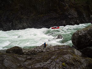
The Rogue River in southwestern Oregon in the United States flows about 215 miles (346 km) in a generally westward direction from the Cascade Range to the Pacific Ocean. Known for its salmon runs, whitewater rafting, and rugged scenery, it was one of the original eight rivers named in the Wild and Scenic Rivers Act of 1968. Beginning near Crater Lake, which occupies the caldera left by the explosive volcanic eruption and collapse of Mount Mazama, the river flows through the geologically young High Cascades and the older Western Cascades, another volcanic province. Further west, the river passes through multiple exotic terranes of the more ancient Klamath Mountains. In the Kalmiopsis Wilderness section of the Rogue basin are some of the world's best examples of rocks that form the Earth's mantle. Near the mouth of the river, the only dinosaur fragments ever discovered in Oregon were found in the Otter Point Formation, along the coast of Curry County.

The Clackamas River is an approximately 83-mile (134 km) tributary of the Willamette River in northwestern Oregon, in the United States. Draining an area of about 940 square miles (2,435 km2), the Clackamas flows through mostly forested and rugged mountainous terrain in its upper reaches, and passes agricultural and urban areas in its lower third. The river rises in eastern Marion County, about 55 miles (89 km) east-southeast of Salem. The headwaters are on the slopes of Olallie Butte in the Mount Hood National Forest, about 10 miles (16 km) north of Mount Jefferson, at an elevation of 4,909 feet (1,496 m) in the Cascade Range. The Clackamas flows briefly north and then flows northwest through the mountains, passing through North Fork Reservoir and Estacada. It then emerges from the mountains southeast of Portland. It joins the Willamette near Oregon City and forms the boundary between Oregon City and Gladstone.

The Salmon River, also known as the "River of No Return", is a river located in the U.S. state of Idaho in the western United States. It flows for 425 miles (685 km) through central Idaho, draining a rugged, thinly populated watershed of 14,000 square miles (36,000 km2). The river drops more than 7,000 feet (2,100 m) from its headwaters, near Galena Summit above the Sawtooth Valley in the Sawtooth National Recreation Area, to its confluence with the Snake River. Measured at White Bird, its average discharge is 11,060 cubic feet per second. The Salmon River is the longest undammed river in the contiguous United States.

The Owyhee River is a tributary of the Snake River located in northern Nevada, southwestern Idaho and southeastern Oregon in the United States. It is 280 miles (450 km) long. The river's drainage basin is 11,049 square miles (28,620 km2) in area, one of the largest subbasins of the Columbia Basin. The mean annual discharge is 995 cubic feet per second (28.2 m3/s), with a maximum of 50,000 cu ft/s (1,400 m3/s) recorded in 1993 and a minimum of 42 cu ft/s (1.2 m3/s) in 1954.

The Chetco River is a 56-mile-long (90 km) stream located in the southwestern portion of the U.S. state of Oregon. It drains approximately 352 square miles (912 km2) of Curry County. Flowing through a rugged and isolated coastal region, it descends rapidly from about 3,200 feet (975 m) to sea level at the Pacific Ocean. Except for the lowermost 5 miles (8 km), the river is located entirely within the Rogue River – Siskiyou National Forest. The river rises in the Kalmiopsis Wilderness, northwest of Chetco Peak at the junction of the Oregon Coast Range and the Klamath Mountains. It flows generally north, west, and then southwest, before emptying into the ocean between Brookings and Harbor, approximately 6 miles (10 km) north of the California state line. The Chetco River's watershed remains largely undeveloped, protected by the Rogue River – Siskiyou National Forest and the Kalmiopsis Wilderness. The upper 45 miles (72 km) of the river have been designated Wild and Scenic since 1988.

The Elk River is in southwestern Oregon in the United States. About 29 miles (47 km) long, the river drains a remote 92-square-mile (240 km2) area of the Coast Range into the Pacific Ocean.

The Aniakchak River is a stream, 27 miles (43 km) long, in Lake and Peninsula Borough on the Alaska Peninsula in the United States. It arises in Surprise Lake in the crater of Mount Aniakchak, a volcano in the Aleutian Range. It flows eastward from Aniakchak National Monument and Preserve into Aniakchak Bay and the Pacific Ocean.

The White Salmon River is a 44-mile (71 km) tributary of the Columbia River in the U.S. state of Washington. Originating on the slopes of Mount Adams, it flows into the Columbia Gorge near the community of Underwood. Parts of the river have been designated Wild and Scenic. The principal tributaries of the White Salmon River include Trout Lake and Buck, Mill, Dry, Gilmer, and Rattlesnake Creeks.

The Applegate River is a 51-mile (82 km)-long tributary of the Rogue River in the U.S. state of Oregon. It drains approximately 698 square miles (1,810 km2). Rising in northern California, it soon crosses the border and flows northeast then northwest to meet the Rogue about 6 miles (9.7 km) west of Grants Pass. It drains forested foothills of the Siskiyou Mountains along the Oregon–California border.
The Red Buttes Wilderness is a wilderness area in the Klamath and Rogue River national forests in the U.S. states of Oregon and California. It comprises 19,940 acres (8,070 ha), approximately 16,190 acres (6,550 ha) of which is located in California, and 3,750 acres (1,520 ha) in Oregon. It was established by the California Wilderness Act of 1984 and the Oregon Wilderness Act of 1984.
The Siskiyou Wilderness is a federal wilderness area designated by the passage of the California Wilderness Act of 1984. Originally, the land area was 153,000 acres (620 km2) The Northern California Wild Heritage Act of 2006 added 30,122 acres (121.90 km2) for the current total of 182,802 acres (739.77 km2). All of the wilderness is in Northern California and is managed by the U.S. Forest Service. The wilderness spans three national forests: the Rogue River–Siskiyou, the Klamath, and the Six Rivers.

Kalmiopsis Wilderness is a wilderness area in the Klamath Mountains of southwestern Oregon, within the Rogue River – Siskiyou National Forest. It was designated wilderness by the United States Congress in 1964 and now comprises a total of 179,755 acres (72,744 ha). There are approximately 153 miles (246 km) of trails on 24 established hiking trails in the area.

Grassy Knob Wilderness is a wilderness area in the Klamath Mountains of southwestern Oregon, within the Rogue River-Siskiyou National Forest. It was designated wilderness by the United States Congress in 1984 and now comprises a total of 17,200 acres (6,961 ha). Like most wilderness areas in Oregon, Grassy Knob is managed by the Forest Service.
The North Fork John Day River is a 107-mile (172 km) tributary of the John Day River in the U.S. state of Oregon. It begins in Grant County about 20 miles (32 km) northwest of Baker City near the crest of the Blue Mountains. It flows generally west to the community of Dale on U.S. Route 395, then southwest through the city of Monument to the unincorporated community of Kimberly, where it meets the main stem of the John Day River.

The Rogue River in the U.S. state of Oregon begins at Boundary Springs on the border between Klamath and Douglas counties near the northern edge of Crater Lake National Park. The Rogue River flows generally west for 215 miles (346 km) from the Cascade Range through the Rogue River – Siskiyou National Forest and the Klamath Mountains to the Pacific Ocean at Gold Beach. Communities along its course include Union Creek, Prospect, Trail, Shady Cove, Gold Hill, and Rogue River, all in Jackson County; Grants Pass, and Galice in Josephine County, and Agness, Wedderburn and Gold Beach in Curry County. Significant tributaries include the South Fork Rogue River, Elk Creek, Bear Creek, the Applegate River, and the Illinois River. Arising at 5,320 feet (1,622 m) above sea level, the river loses more than 1 mile (1.6 km) in elevation by the time it reaches the Pacific.
The South Fork Rogue River is a 25-mile (40 km) tributary of the Rogue River in the U.S. state of Oregon. Rising in the Sky Lakes Wilderness in the Cascade Range, it flows generally northeast through the Rogue River – Siskiyou National Forest to meet the Rogue River downstream of Prospect and slightly upstream of Lost Creek Lake.
Illahe is an unincorporated community and the site of a former post office in Curry County, Oregon, United States. Located along the Rogue River about 8 miles (13 km) upriver from Agness, the area was home to Takelma Indians, then to white and Karok settlers, before becoming part of a designated wilderness. In the 21st century, it is a stopping place for hikers, boaters, and other visitors. The area has a riverside lodge and a nearby campground, both named Illahe.

Marial is an unincorporated community and the site of a former post office in Curry County, Oregon, United States. Located along the Rogue River about 48 miles (77 km) from its mouth on the Pacific Ocean, the area was home to Takelma Indians, then to white and Karok settlers, before becoming part of a designated wilderness. Buildings preserved at the Rogue River Ranch pioneer farm complex, listed on the National Register of Historic Places, represent the former center of Marial. Nearby are the Tucker Flat Campground and a riverside lodge named Marial.
The Illinois River Trail, known on maps as National Trail No. 1161, is a hiking trail located in the Siskiyou National Forest in Oregon, United States. The 27-mile (43 km) trail provides access to the Kalmiopsis Wilderness in the Klamath Mountains.
The North Fork Smith River is 28-mile (45 km) tributary of the Smith River that begins in the U.S. state of Oregon and ends in the U.S. state of California. Arising near Chetco Peak in the Klamath Mountains, it flows generally south to meet the Middle Fork Smith River at Gasquet, California. The combined streams form the Smith River.