The wilderness was originally designated the Alpine Lakes Limited Area in 1946, but this designation did not offer protection from resource extractions and was exclusively regulated by the United States Forest Service.[2] The region and adjacent areas were being extensively used for mining, timber extraction, and fur trapping leading to roads, clear cuts and ecological degradation.[3] Efforts to further protect the lower valley forests of Alpine Lakes began in the 1950s by the North Cascades Conservation Council formed in 1957 and in October 1968 the Alpine Lakes Protection Society was formed.[3] However, it was the plans of the Snoqualmie National Forest to expand timber sales and build a road up the Miller River valley to Lake Dorothy and then onto the Middle Fork of the Snoqualmie River to the city of North Bend that started a grassroots campaign to remove the unilateral decision-making authority away from the Forest Service.[3] In addition, there was much criticism by conservationists that recreational usage should not be exclusive to the upper alpine terrain as the regional forestry leadership advocated saving the lower forests for possible timber sales.[3] A powerful and key amendment to the Wilderness Act by Wayne Aspinall, a Colorado congressman, gave Congress and not federal land agencies the ability to propose, debate, and vote on new wilderness designations.[3]
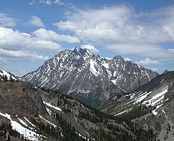
Mount Stuart, 9,415 feet (2,870m), the highest point in the wilderness area
After exhausting debates, public meetings and with even a request by the Forest Service to veto, President Ford signed the Alpine Lakes Area Management Act into law on the afternoon of July 12, 1976, reportedly saying "anywhere so beautiful should be preserved." Following this designation four properties in the Alpine Lakes Area were listed in the National Register of Historic Places: Stevens Pass Historic District, Salmon La Sac Guard Station, the Blewett Arrastra and the townsite of Liberty.[4]
Expansion
On December 12, 2014, Congress passed legislation expanding the Alpine Lakes Wilderness by 22,000 acres in the Middle Fork Snoqualmie Valley and granting National Wild and Scenic River status to sections of the Middle Fork Snoqualmie and Pratt Rivers.[5] The legislation was included as part of a package of 100 public lands bills attached to the 2015 National Defense Authorization Act.[5] President Obama signed the legislation into law on December 19, 2014, marking the first major wilderness area designation in Washington State since the addition of Wild Sky Wilderness in 2008.
Geology
Lila Lake on Rampart Ridge with Hibox Mountain, 6,547ft (1,996m), behind
The Alpine Lakes Wilderness features some of the most rugged topography in the Cascade Range with craggy peaks and ridges, deep glacial valleys, and granite walls spotted with over 700 mountain lakes.[6] Geological events occurring many years ago created the diverse topography and drastic elevation changes over the Cascade Range leading to the various climate differences. These climate differences lead to vegetation variety defining the ecoregions in this area. The elevation range of this area is between about 1,000 feet (300m) in the lower elevations to over 9,000 feet (2,700m) on Mount Stuart.[4]
During the Pleistocene period dating back over two million years ago, glaciation advancing and retreating repeatedly scoured the landscape leaving deposits of rock debris.[7] The last glacial retreat in the Alpine Lakes area began about 14,000 years ago and was north of the Canada–US border by 10,000 years ago.[7] The U-shaped cross section of the river valleys is a result of that recent glaciation.[4]Uplift and faulting in combination with glaciation have been the dominant processes which have created the tall peaks and deep valleys of the Alpine Lakes Wilderness area.[4]
The Alpine Lakes Wilderness offers many ecological benefits. The wilderness offers exceptional water quality and holds portions, or all of, the headwaters for the Skykomish, Snoqualmie, Wenatchee, and Yakima Rivers.[4] The Skykomish and Snoqualmie Rivers flow to the west into the Snohomish River and the Wenatchee and Yakima Rivers flow eastward into the Columbia River. In addition to over 700 lakes this area offers over 300 miles (480km) of Forest Service class one and two streams.[4] The Alpine Lakes Wilderness plays a significant role in both domestic water use and irrigation in its surrounding region.[4] This is critical with the increasing challenge to provide an adequate supply of clean water with the growing population and increase in agricultural demands.[9] Expansion of the Alpine Lakes Wilderness into the Pratt River area would allow for further protection of the lower elevation forests of this region and the lower water shed. In addition, those forests serve to reduce flooding.
The Alpine Lakes Wilderness is managed by the Mount Baker-Snoqualmie National Forest in the west and the Okanogan-Wenatchee National Forest in the east.[10] There are four Ranger Districts—Cle Elum, Leavenworth, Snoqualmie, and Skykomish—that administer this land.[10] The Alpine Lakes Wilderness area is one of the most popular outdoor recreational areas in the State of Washington. Although this area has the wilderness designation and no motorized vehicles such as cars, motorcycles, or even bicycles can operate in this area, there is heavy foot traffic and camping throughout. Because of this heavy foot traffic, managing the Alpine Lakes Wilderness area to preserve its integrity is very challenging.[10] This recreational area's popularity has led to physical, biological, and social impacts.[10]
The Forest Service has taken many steps to minimize the environmental impacts of heavy recreational use.[10] Education/information is a primary method used by the Forest Service.[10] Other methods include Wilderness Ranger contacts, regulation, permits, restoration efforts, and trail clearing.[10] Due to the popularity of the Enchantment Lakes area within the Alpine Lakes Wilderness, wilderness permits are required. These permits must be applied for well in advance of the visit and are awarded at random.
Recreation
Mount Daniel, 7,960ft (2,426m), with early fall snow
The western end of the Alpine Lakes Wilderness is accessible via the Middle Fork of the Snoqualmie River northeast of North Bend, Washington. Snoqualmie Pass provides access to the southwestern end of the wilderness. Salmon La Sac north of Roslyn, Washington is a hub for trailheads and U.S. Forest Service roads providing entry into the southern and central regions. The Stuart Range on the eastern end of the wilderness is accessible by Ingalls Creek on the south and Icicle Creek, near Leavenworth, Washington, on the north. North of Icicle Creek are the Chiwaukum Mountains which stretch northwards to Highway 2. The northern parts of the Alpine Lakes are accessible from Highway 2 and Stevens Pass.[11][12]
A segment of the Pacific Crest Trail leads from Snoqualmie Pass to Stevens Pass and includes the Kendall Catwalk on Kendall Peak. This exposed section should not be attempted in snowy or icy conditions.
↑16 U.S.C.§1131: Public Law 88-577 "Wilderness Act" The definition of wilderness was defined by law as "... an area where the earth and its community of life are untrammeled by man, where man himself is a visitor who does not remain. An area of wilderness is further defined to mean in this Act an area of undeveloped Federal land retaining its primeval character and influence, without permanent improvements or human habitation, which is protected and managed so as to preserve its natural conditions..."
12345Marsh, Kevin (2007). Drawing Lines in the Forest. Seattle: University of Washington Press.
1234567891011Alpine Lakes Area Land Management Plan (Report). USDA Forest Service. 1981.
This page is based on this Wikipedia article Text is available under the CC BY-SA 4.0 license; additional terms may apply. Images, videos and audio are available under their respective licenses.