
The Snoqualmie River is a 45-mile (72 km) long river in King County and Snohomish County in the U.S. state of Washington. The river's three main tributaries are the North, Middle, and South Forks, which drain the west side of the Cascade Mountains near the town of North Bend and join near the town of Snoqualmie just above the Snoqualmie Falls. After the falls the river flows north through rich farmland and the towns of Fall City, Carnation, and Duvall before meeting the Skykomish River to form the Snohomish River near Monroe. The Snohomish River empties into Puget Sound at Everett. Other tributaries of the Snoqualmie River include the Taylor River and the Pratt River, both of which enter the Middle Fork, the Tolt River, which joins at Carnation, and the Raging River at Fall City.

The North Cascades are a section of the Cascade Range of western North America. They span the border between the Canadian province of British Columbia and the U.S. state of Washington and are officially named in the U.S. and Canada as the Cascade Mountains. The portion in Canada is known to Americans as the Canadian Cascades, a designation that also includes the mountains above the east bank of the Fraser Canyon as far north as the town of Lytton, at the confluence of the Thompson and Fraser Rivers.

The Sauk River is a tributary of the Skagit River, approximately 45 miles (72 km) long, in northwestern Washington in the United States. It drains an area of the high Cascade Range in the watershed of Puget Sound north of Seattle. The river is a popular destination for fly fishing. It is a National Wild and Scenic River.

The Washougal River is a 33-mile (53 km) tributary of the Columbia River in the U.S. state of Washington. Its headwaters and upper 21 miles (34 km) are in Skamania County in the Gifford Pinchot National Forest, and its lower 12 miles (19 km) are in Clark County. The river, which flows through the city of Washougal and meets the Columbia at the City of Camas, is a popular stream for fishing, swimming, and boating.

Barr Creek Falls, is a waterfall located in the Rogue River Canyon within the Prospect State Scenic Viewpoint in Jackson County, in the U.S. state of Oregon. The waterfall is located at the south end of Barr Creek as it plunges into the Rogue River over a carved cliff surrounded by walls of petrified volcanic ash as a consequence of the Mount Mazama eruption. The waterfall has also been called Bear Creek Falls. The waterfall gets its name from the creek which was called "Barr" for the presence of a fence that prevented cattle from straying out of the local Red Blanket Ranch and that ran adjacent to the creek.
Wallace Falls State Park is a public recreation area that encompasses 1,380 acres (560 ha) along the Wallace River in Snohomish County, Washington. The state park is located on the west side of the Cascade Mountains with an entrance point one mile (1.6 km) northeast of the community of Gold Bar. The park features three waterfalls, three backcountry lakes, old-growth coniferous forests, rushing mountain rivers and streams, and the evidence of its logging history in the ruins of railroad trestles, disused railroad grades, and springboard notches in stumps.
Blum Basin Falls is a waterfall in Whatcom County, in the U.S. state of Washington. It is located in North Cascades National Park on the headwaters of Blum Creek, a tributary of the Baker River. Fed by two small retreating glaciers and several snowfields on the southern side of Mount Blum, the waterfall is formed by the largest meltwater stream that feeds the mainstem of Blum Creek. The falls tumble 1,680 feet (510 m) down a high glacial headwall several miles within the national park in two distinct stages; the first is a series of slides over rounded rock, above the tree line, and the second is a series of near-vertical plunges to the forested valley below. Although most of the falls is clearly visible, parts of it are obscured by tall pines that grow at its base. There is no trail leading to the waterfall.
Bear Lake is a lake in King County in Washington, United States. It is the source of the Taylor River.
Snoqualmie Lake is a lake in King County, Washington. It is an expansion of the Taylor River and is located a short distance downstream from Deer Lake. It is the largest of the three lakes along the upper reaches of the Taylor.
The Miller River is a river in King County, Washington. Named for 1890s prospector John Miller, it is a tributary of the Skykomish River, which it joins near the community of Miller River. The Miller River is about 3.5 miles (5.6 km) long from the confluence of its main tributaries, the East Fork and West Fork. Miller River Campground is located just downriver from the confluence.
There are a total of 3 waterfalls on the 2 forks of the Miller River. Below is a description for all of them:

Sulphide Creek Falls is a tall, moderately large volume waterfall within North Cascades National Park in Washington state that is one of the tallest waterfalls in North America. The falls drop from Sulphide Lake on the southeast side of Mount Shuksan down a narrow flume-like canyon to a broad basin below. Because of the narrow, twisting shape of the canyon the waterfall is exceptionally difficult to see from ground-level perspectives. The total vertical drop of the waterfall is in the range of 2,100 feet (640 m) to 2,200 feet (670 m) feet, but it has not yet been accurately measured. Foot access to the bottom of the waterfall involves 2.5 miles (4.0 km) of off-trail travel in extremely brushy terrain and several potentially dangerous fords of a large stream.
The valley of the West Fork Foss River contains a fair amount of waterfalls. The river heads in a series of large lakes: Big Heart Lake, Angeline Lake, and Otter Lake- which form spectacular waterfalls as they plunge down to Delta Lake. On the valley walls downstream of Delta Lake, are found even more waterfalls.

Salt Creek Falls is a cascade and plunge waterfall on Salt Creek, a tributary of the Middle Fork Willamette River, that plunges into a gaping canyon in the Willamette National Forest near Willamette Pass in Lane County, Oregon. The waterfall is notable for its main drop of 286 feet (87 m), ranking third highest among plunge waterfalls in Oregon, after Multnomah Falls and Watson Falls.) The pool at the bottom of Salt Creek Falls waterfall is 66 feet (20 m) deep.

Falls Creek, also known as the Falls River, is a tributary of the Tuolumne River in Yosemite National Park, California, United States. The creek begins at the northern boundary of the national park and flows 24 miles (39 km) to empty into the Tuolumne at Hetch Hetchy Reservoir, dropping over two well-known waterfalls. The Pacific Crest Trail and other national park trails follow the creek for much of its course.
Yakso Falls is a 70-foot (21 m) waterfall on Little River, in the Cascade Range east of Roseburg in the U.S. state of Oregon. The waterfall is about 27 miles (43 km) from the unincorporated community of Glide along Little River Road, which becomes Forest Road 27.
Swampy Creek Falls is a scenic, two-tiered horsetail waterfall along an unnamed tributary of the White Salmon River, originating from Swampy Meadows, on Mount Adams west slope, with a total height of 52 ft (16 m). Its main drop is about 30 ft (9 m) feet. It cascades down over an exposure of andesite, then veiling out over sloped ledges below, among a secluded forest. The falls are located not more than 800 feet from Forest Route 23, and is noted for having a secluded nature, seeming as if nothing is around for miles. It can be accessed while heading to the Midway High Lakes Area and Takhlakh Lake from Trout Lake or the Lewis River. From the road, viewers have to follow the Pacific Crest Trail for a few hundred feet, then crossing an unnamed stream on a footbridge. From here, hikers must follow the creek downstream to the top of the falls, then descending down to its base. The falls is managed by the Gifford Pinchot National Forest, of Washington state.
Yocum Falls, is a waterfall located in the heart of the Mount Hood National Forest, in Clackamas County, in the U.S. state of Oregon. It is located in a privileged area in Zigzag canyon with several waterfalls including Little Zigzag Falls and Ramona Falls. The name, as well as Yocum Ridge, the south ridge of the Sandy Glacier on the west slope of Mount Hood, comes from businessman Oliver C. Yocum.

Deception Creek is a river that is located in Northwestern King County, Washington. The river starts at the outlet of Trico Lake on Trico Mountain and flows north before flowing into Tye River east of Skykomish. The last stretch of Deception Creek before joining the Tye River forms a cliff that houses the Deception Falls, an 86 feet waterfall.
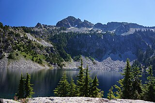
Gold Lake is a freshwater lake located on a valley on the west skirt of Wild Goat Peak, in King County, Washington. Gold Lake is surrounded by prominent peaks and lakes at the heart of the Alpine Lakes Wilderness, including Big Snow Mountain and Iron Cap Mountain.


