This article relies largely or entirely on a single source .(November 2022) |
There are a total of 3 waterfalls on the 2 forks of the Miller River. Below is a description for all of them:
This article relies largely or entirely on a single source .(November 2022) |
There are a total of 3 waterfalls on the 2 forks of the Miller River. Below is a description for all of them:
| Florence Falls | |
|---|---|
| Location | King County, Washington, United States |
| Type | Tiered |
| Total height | 140 feet (43 m) |
| Number of drops | 4 |
| Total width | 20 feet (6.1 m) |
| Watercourse | East Fork Miller River |
Florence Falls, at 47°35′59″N121°23′00″W / 47.59972°N 121.38333°W , is located a short distance downstream from Lake Dorothy. The falls are a long cascade totaling about 140 feet (43 m). The falls are made up of several small drops, none over 20 feet high, and can be just a trickle when the river is really low or likely quite large when the river is high. [1]
The location of this waterfall is often marked on older maps as being just downstream of the mouth of Smith Creek. The true location is just below the outlet of Lake Dorothy, at a bend in the river. The falls are located within a narrow gorge.
| Borderline Falls | |
|---|---|
| Location | King County, Washington, United States |
| Type | Cascade |
| Total height | 20 feet (6.1 m) |
| Number of drops | 1 |
| Total width | 10 feet (3.0 m) |
| Watercourse | West Fork Miller River |
Borderline Falls, at 47°39′33″N121°24′44″W / 47.65917°N 121.41222°W , is a located about 1.5 miles upstream from the mouth of the West Fork and about 0.6 miles above Immigration Falls. They occur where the river is squeezed between two large granite slabs and cascades for about 20 feet. It got its name due to the amount of kayakers who run it as well as the river above or below the falls. [2]
| Immigration Falls | |
|---|---|
| Location | King County, Washington, United States |
| Type | Horsetail |
| Total height | 20 feet (6.1 m) |
| Number of drops | 1 |
| Total width | 10 feet (3.0 m) |
| Watercourse | West Fork Miller River |
Immigration Falls, at 47°39′55″N121°24′01″W / 47.66528°N 121.40028°W , is located about 0.9 miles above the mouth of the West Fork and about 0.6 miles downstream from Borderline Falls. They occur where the river drops over a huge boulder and into another. It got its name due to the amount of kayakers who run it as well as the river above or below the falls. [3]

The Snoqualmie River is a 45-mile (72 km) long river in King County and Snohomish County in the U.S. state of Washington. The river's three main tributaries are the North, Middle, and South Forks, which drain the west side of the Cascade Mountains near the town of North Bend and join near the town of Snoqualmie just above the Snoqualmie Falls. After the falls the river flows north through rich farmland and the towns of Fall City, Carnation, and Duvall before meeting the Skykomish River to form the Snohomish River near Monroe. The Snohomish River empties into Puget Sound at Everett. Other tributaries of the Snoqualmie River include the Taylor River and the Pratt River, both of which enter the Middle Fork, the Tolt River, which joins at Carnation, and the Raging River at Fall City.

The Feather River is the principal tributary of the Sacramento River, in the Sacramento Valley of Northern California. The river's main stem is about 73 miles (117 km) long. Its length to its most distant headwater tributary is just over 210 miles (340 km). The main stem Feather River begins in Lake Oroville, where its four long tributary forks join—the South Fork, Middle Fork, North Fork, and West Branch Feather Rivers. These and other tributaries drain part of the northern Sierra Nevada, and the extreme southern Cascades, as well as a small portion of the Sacramento Valley. The total drainage basin is about 6,200 square miles (16,000 km2), with approximately 3,604 square miles (9,330 km2) above Lake Oroville.

The Sauk River is a tributary of the Skagit River, approximately 45 miles (72 km) long, in northwestern Washington in the United States. It drains an area of the high Cascade Range in the watershed of Puget Sound north of Seattle. The river is a popular destination for fly fishing. It is a National Wild and Scenic River.
Burgess Falls State Park is a state park and state natural area in Putnam County and White County, Tennessee, located in the southeastern United States. The park is situated around a steep gorge in which the Falling Water River drops 250 feet (76 m) in elevation in less than a mile, culminating in a 136-foot (41 m) cataract waterfall.

Rock Island State Park is a state park in Warren County and White County, Tennessee, located in the Southeastern United States. The park is named after the community of Rock Island, Tennessee, which in turn received its name from an island on the Caney Fork upstream from the Collins River confluence and Great Falls Dam. Rock Island State Park is centered on a peninsula created by the confluence of these two rivers and extends downstream to the headwaters of Center Hill Lake.

The Salmon River is a 33.5-mile (53.9 km) river in the Cascade Range in the U.S. state of Oregon that drains part of southwestern Mount Hood. The entire length of the river is a protected National Wild and Scenic River. Several portions are in protected wilderness. It is affluent to the Sandy River, a tributary of the Columbia River.
The Row River is a river, approximately 20 miles (32 km) long, in Lane County, Oregon, United States. It rises in the Cascade Range and flows into the Coast Fork Willamette River near Cottage Grove. The stream was originally known as the "East Fork Coast Fork", but was later renamed after a dispute between neighbors and brothers-in-law George Clark and Joseph Southwell over "trespassing" livestock. Clark was killed as a result of the row. The name rhymes with "cow" rather than with "slow". A post office named Row River operated from 1911 to 1914 a little north of the present site of Dorena at 43.740123°N 122.880347°W.
Foss River Falls is a 650-foot (200 m) drop on the West Fork Foss River in the Alpine Lakes Wilderness Area, King County, Washington. Its sources are at Delta Lake, and the 70-foot (21 m)-wide drop flows year-round. The waterfall is split into two parts. Each part is split into several tiers.
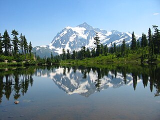
There are four prominent waterfalls in the basin of a short tributary of Sulphide Creek, on the southeast flank of 9,127-foot (2,781m) Mount Shuksan in North Cascades National Park, Washington. Seahpo Peak Falls and Cloudcap Falls, the taller two of the three, are located on separate streams that converge and plunge over Rockflow Canyon Falls. The unnamed outlet stream from these waterfalls flows into Sulphide Creek, which flows into the Baker River. Another waterfall is Jagged Ridge Falls, on a tributary of the unnamed stream.
Deer Falls is the uppermost waterfall on the North Fork Skykomish River. The falls occur within a short but impressive canyon just above the mouth of Goblin Creek.
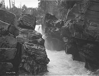
Canyon Falls is the second of the three waterfalls on the South Fork Skykomish River. The falls occur about halfway between Eagle Falls and Sunset Falls.
Eagle Falls is the uppermost waterfall on the South Fork Skykomish River in Washington. The falls are located downstream from the town of Baring and drop about 25 feet in a high volume cascade.

Sunset Falls is the final of the three waterfalls on the South Fork Skykomish River. The falls drop 104 feet (32 m) in a long, narrow, powerful chute. The river is thought to attain speeds of 60 kilometres (37 mi) an hour and the chute is nearly 300 feet (91 m) long. In high water, because of several potholes in the falls, water can sometimes shoot out as much as 30 feet.
The Boulder River is home to 3 waterfalls, one just below its headwaters and the other 2 closer to its mouth. Below are descriptions of all 3:

Eagle Creek is a tributary of the Columbia River in Multnomah and Hood River counties in the U.S. state of Oregon. It cuts through a narrow canyon in its 3,200 feet (980 m) descent to the Columbia River Gorge and is known for its concentration of 13 waterfalls in about 5 miles (8.0 km) distance. Eight major falls are on Eagle Creek and the East Fork Eagle Creek itself, while five are on its tributaries.
There are multiple waterfalls in the basin of the North Fork Cascade River, a river in the North Cascades of Washington that drains to the Cascade River. Many of these are taller than the more famous waterfalls in North America, but do not receive much attention due to their remoteness.
The Paradise River in Washington state, United States, is known for having a total of eight major waterfalls.
The valley of the West Fork Foss River contains a fair amount of waterfalls. The river heads in a series of large lakes: Big Heart Lake, Angeline Lake, and Otter Lake- which form spectacular waterfalls as they plunge down to Delta Lake. On the valley walls downstream of Delta Lake, are found even more waterfalls.

Salt Creek Falls is a cascade and plunge waterfall on Salt Creek, a tributary of the Middle Fork Willamette River, that plunges into a gaping canyon in the Willamette National Forest near Willamette Pass in Lane County, Oregon. The waterfall is notable for its main drop of 286 feet (87 m), ranking third highest among plunge waterfalls in Oregon, after Multnomah Falls and Watson Falls.) The pool at the bottom of Salt Creek Falls waterfall is 66 feet (20 m) deep.
Pringle Falls is a series of rapids or drops on the upper Deschutes River in the U.S. state of Oregon. From just downstream of Wyeth Campground, the rapids begin with about 600 feet (180 m) of whitewater rated class II (novice) on the International Scale of River Difficulty. The next 300 feet (91 m) is class III (intermediate] ending in a class IV drop. Soggy Sneakers: A Paddler's Guide to Oregon's Rivers says, "Only expert kayakers should consider this drop, and only after scouting. It is definitely not a rapids for open canoes."