
The Snoqualmie River is a 45-mile (72 km) long river in King County and Snohomish County in the U.S. state of Washington. The river's three main tributaries are the North, Middle, and South Forks, which drain the west side of the Cascade Mountains near the town of North Bend and join near the town of Snoqualmie just above the Snoqualmie Falls. After the falls the river flows north through rich farmland and the towns of Fall City, Carnation, and Duvall before meeting the Skykomish River to form the Snohomish River near Monroe. The Snohomish River empties into Puget Sound at Everett. Other tributaries of the Snoqualmie River include the Taylor River and the Pratt River, both of which enter the Middle Fork, the Tolt River, which joins at Carnation, and the Raging River at Fall City.

The Vedder River, called the Chilliwack River above Vedder Crossing, is a river in the Canadian province of British Columbia and the U.S. state of Washington.

The Tsitsikamma National Park is a protected area on the Garden Route, Western Cape and Eastern Cape, South Africa. It is a coastal reserve well known for its indigenous forests, dramatic coastline, and the Otter Trail. On 6 March 2009 it was amalgamated with the Wilderness National Park and various other areas of land to form the Garden Route National Park.

Bridal Veil Falls is a waterfall in the DuPont State Forest, on the Little River, near Brevard, North Carolina.
Depot Creek Falls is a 967-foot (295 m)-high waterfall in the North Cascades National Park, Whatcom County, Washington.

Bridal Veil Falls is a 1,328-foot (405 m) waterfall that flows from Lake Serene directly to the South Fork Skykomish River on the creek of the same name in the U.S. state of Washington. It is a perennial 150-foot (46 m) wide drop with four tiers, two of which are clearly visible. It is at 47.78950°N 121.56924°W.
Blum Basin Falls is a waterfall in Whatcom County, in the U.S. state of Washington. It is located in North Cascades National Park on the headwaters of Blum Creek, a tributary of the Baker River. Fed by two small retreating glaciers and several snowfields on the southern side of Mount Blum, the waterfall is formed by the largest meltwater stream that feeds the mainstem of Blum Creek. The falls tumble 1,680 feet (510 m) down a high glacial headwall several miles within the national park in two distinct stages; the first is a series of slides over rounded rock, above the tree line, and the second is a series of near-vertical plunges to the forested valley below. Although most of the falls is clearly visible, parts of it are obscured by tall pines that grow at its base. There is no trail leading to the waterfall.

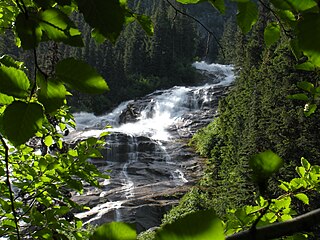
The Pratt River is a river in King County in Washington. It is a tributary of the Middle Fork Snoqualmie River. It was named for prospector George A Pratt, who discovered nearby iron deposits in 1887.
Bear Lake is a lake in King County in Washington, United States. It is the source of the Taylor River.
Van Trump Creek, also called Van Trump Falls Creek or the Van Trump Fork of the Nisqually River, is a creek in Pierce County, Washington. It is a tributary of the Nisqually River, joining the river just above the mouth of the Paradise River. The creek is known for having several well known waterfalls along its course.
Deer Lake is a lake in King County, Washington. It is an expansion of the Taylor River, located just below its true source. Located a short distance downstream is Snoqualmie Lake.
Snoqualmie Lake is a lake in King County, Washington. It is an expansion of the Taylor River and is located a short distance downstream from Deer Lake. It is the largest of the three lakes along the upper reaches of the Taylor.
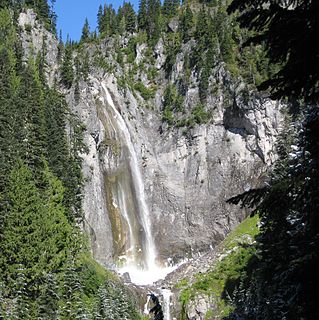
The Miller River is a river in King County, Washington. Named for 1890s prospector John Miller, it is a tributary of the Skykomish River, which it joins near the community of Miller River. The Miller River is about 3.5 miles (5.6 km) long from the confluence of its main tributaries, the East Fork and West Fork. Miller River Campground is located just downriver from the confluence.

Eagle Creek is a tributary of the Columbia River in Multnomah and Hood River counties in the U.S. state of Oregon. It cuts through a narrow canyon in its 3,200 feet (980 m) descent to the Columbia River Gorge and is known for its concentration of 13 waterfalls in about 5 miles (8.0 km) distance. Eight major falls are on Eagle Creek and the East Fork Eagle Creek itself, while five are on its tributaries.
The Rainy River is a short river that enters the Thornbrough Channel at Port Mellon, British Columbia, Canada. While it does come close to doing so, it never enters Tetrahedron Provincial Park.

The geography of the North Cascades describes a range of rugged mountains in British Columbia, Canada and Washington, United States. In Canada, the range is officially named the Cascade Mountains but is commonly referred to as the Canadian Cascades.
The valley of the West Fork Foss River contains a fair amount of waterfalls. The river heads in a series of large lakes: Big Heart Lake, Angeline Lake, and Otter Lake- which form spectacular waterfalls as they plunge down to Delta Lake. On the valley walls downstream of Delta Lake, are found even more waterfalls.

The Rogue River in the U.S. state of Oregon begins at Boundary Springs on the border between Klamath and Douglas counties near the northern edge of Crater Lake National Park. The Rogue River flows generally west for 215 miles (346 km) from the Cascade Range through the Rogue River – Siskiyou National Forest and the Klamath Mountains to the Pacific Ocean at Gold Beach. Communities along its course include Union Creek, Prospect, Trail, Shady Cove, Gold Hill, and Rogue River, all in Jackson County; Grants Pass, and Galice in Josephine County, and Agness, Wedderburn and Gold Beach in Curry County. Significant tributaries include the South Fork Rogue River, Elk Creek, Bear Creek, the Applegate River, and the Illinois River. Arising at 5,320 feet (1,622 m) above sea level, the river loses more than 1 mile (1.6 km) in elevation by the time it reaches the Pacific.
Marten Lake is a freshwater lake located on the southern slope of Dog Mountain west of Anderson Lake, part of the Alpine Lakes Wilderness in King County, Washington. Marten creek exits Marten Lake into a canyon that produces a tributary to Taylor River. Because of its proximity to Dog Mountain summit and the cirque of Rooster Mountain to the west, the lake is a popular area for hiking, swimming, and fishing cutthroat trout and rainbow trout. Access to Marten Lake is in the heart of the Alpine Lakes Wilderness through an unmaintained fisherman's access trail that spins off the Snoqualmie Lake Trail.