Related Research Articles

Snoqualmie Pass is a census-designated place (CDP) in Kittitas County, Washington, United States. It includes the unincorporated community of Hyak. The population was 311 at the 2010 census.

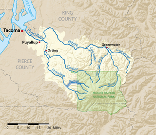
The Snoqualmie River is a 45-mile (72 km) long river in King County and Snohomish County in the U.S. state of Washington. The river's three main tributaries are the North, Middle, and South Forks, which drain the west side of the Cascade Mountains near the town of North Bend and join near the town of Snoqualmie just above the Snoqualmie Falls. After the falls the river flows north through rich farmland and the towns of Fall City, Carnation, and Duvall before meeting the Skykomish River to form the Snohomish River near Monroe. The Snohomish River empties into Puget Sound at Everett. Other tributaries of the Snoqualmie River include the Taylor River and the Pratt River, both of which enter the Middle Fork, the Tolt River, which joins at Carnation, and the Raging River at Fall City.

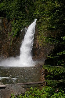
Snoqualmie Falls is a 268-foot (82 m) waterfall in the northwest United States, located east of Seattle on the Snoqualmie River between Snoqualmie and Fall City, Washington. It is one of Washington's most popular scenic attractions, but is perhaps best known internationally for its appearance in the cult television series Twin Peaks. More than 1.5 million visitors come to the Falls every year, where there is a two-acre park, an observation deck, and a gift shop.

Norse Peak Wilderness is a 52,315-acre (21,171 ha) designated wilderness area located in central Washington in the United States. It protects the portion of the Cascade Range north of Chinook Pass, south of Naches Pass, and east of Mount Rainier National Park. It is bordered by the William O. Douglas Wilderness to the south. The wilderness is named for a prominent peak which overlooks Crystal Mountain Ski Area. Roughly triangular, it is about 10 miles (16 km) across and contains no roads.

Glacier Peak Wilderness is a 566,057-acre (229,075 ha), 35-mile-long (56 km), 20-mile-wide (32 km) wilderness area located within portions of Chelan, Snohomish, and Skagit counties in the North Cascades of Washington. The area lies within parts of Wenatchee National Forest and Mount Baker National Forest and is characterized by heavily forested stream courses, steep-sided valleys, and dramatic glacier-crowned peaks. The dominant geologic feature of the area is 10,541-foot (3,213 m) Glacier Peak. It is the most remote major volcanic peak in the Cascade Range and has more active glaciers than any other place in the lower forty-eight states. Glacier Peak is a volcanic cone of basalt, pumice, and ash which erupted during periods of heavy glaciation.

Iron Horse State Park, part of the Washington State Park System, is a 1,612-acre (7 km2) state park located in the Cascade Mountains and Yakima River Valley, between Cedar Falls on the west and the Columbia River on the east.

The Snoqualmie Valley Regional Trail is a rail trail in King County, Washington, United States. The 29-mile (47 km) trail follows a portion of the former alignment of the Milwaukee Road, which was constructed in 1911 and abandoned in 1973.
Kanim Falls (200 ft) is the major waterfall on the North Fork of the Snoqualmie River. It is located at the outlet of Kanim Lake and is near the source of the North Fork of the Snoqualmie River.
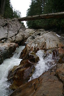
Weeks Falls is a waterfall on the South fork of the Snoqualmie River, located just south of Interstate 90 at exit 38. The falls are at the end of the road that goes past the Olallie State Park ranger headquarters. From the gravel parking lot, there is a paved accessible overlook to see the falls and a small area around the hydro-electric plant. Also, there is a 1/4 mile accessible interpretive trail nearby.
Franklin Falls is a waterfall on the South fork of the Snoqualmie River, the first of three major waterfalls on the South Fork Snoqualmie River. The falls are located near Snoqualmie Pass in King County, Washington, United States, between the north and south lanes of Interstate 90, just east of exit 47. The falls actually consist of three tiers, totaling about 135 feet (41 m). The first drop is a very scenic 15-foot (4.6 m) block-shaped fall. The second drop is a 25-foot (7.6 m) fanning cascade. The final drop begins as a 25-foot slide, which bends to the right, then plunges over the final 70-foot (21 m) drop seen from the base of the falls. The falls are popular canyoneering destination. The upper two drops are north of the freeway.
Twin Falls is a waterfall on the South fork of the Snoqualmie River, off exit 34 on I-90 in the Olallie State Park. Twin Falls features a well-hidden underground run-of-the-river hydroelectric project that generates 24 MW of electricity. The powerhouse is located 325 feet below ground.
The Mowich River is a river in the U.S. state of Washington. Its watershed drains a portion of the western side of Mount Rainier, part of the Cascade Range. The river has two main headwater branches, the South Mowich River and the North Mowich River. The South Mowich is significantly larger and sometimes considered the main river. The Mowich and its tributaries drain several of Mount Rainier's glaciers. The upper portion of its watershed is contained within Mount Rainier National Park. The river flows into the Puyallup River in the foothills west of Mount Rainier.

Snoqualmie Pass is a mountain pass that carries Interstate 90 (I-90) through the Cascade Range in the U.S. state of Washington. The pass summit is at an elevation of 3,015 feet (919 m), on the county line between Kittitas County and King County.

The Pratt River is a river in King County in Washington. It is a tributary of the Middle Fork Snoqualmie River. It was named for prospector George A Pratt, who discovered nearby iron deposits in 1887.
The Taylor River is a river in King County in Washington.
Bear Lake is a lake in King County in Washington, United States. It is the source of the Taylor River.
Snoqualmie Lake is a lake in King County, Washington. It is an expansion of the Taylor River and is located a short distance downstream from Deer Lake. It is the largest of the three lakes along the upper reaches of the Taylor.
There are a total of 3 waterfalls on the 2 forks of the Miller River. Below is a description for all of them:

The Snoqualmie Falls Hydroelectric Plant is located just north of Snoqualmie in King County, Washington state, US. It is situated about 22 mi (35 km) east of Seattle. Located just below the Snoqualmie Falls, the power plant consists of two power houses, Plant 1 and Plant 2. Plant 1 was completed in 1899 and is located underground. It is the first completely underground hydroelectric power plant ever built in the world. Plant 2 was built in 1910 and is located along the right bank of the Snoqualmie River. Both plants receive water from a small reservoir created by a weir atop the falls. Plant 1 has an installed capacity of 13.7 MW and Plant 2 a capacity of 40.2 MW for a total installed capacity of 53.9 MW, enough to power 40,000 homes.
Big Heart Lake is the most remote and highest-elevation on-trail lake in the West Fork Foss River system. It is a 14.6-mile (23.5 km) round-trip hike from the trailhead, just off of the Foss River Road. The lake is located in the Alpine Lakes Wilderness Area within King County, Washington.