Roslyn, Washington

Last updated

Roslyn, Washington
Roslyn-1.jpg
Downtown Roslyn
Kittitas County Washington Incorporated and Unincorporated areas Roslyn Highlighted.svg
Location of Roslyn, Washington
Coordinates: 47°13′30″N121°0′11″W / 47.22500°N 121.00306°W / 47.22500; -121.00306
Country United States
State Washington
County Kittitas
Area
[1]
  Total4.39 sq mi (11.37 km2)
  Land4.39 sq mi (11.37 km2)
  Water0.00 sq mi (0.00 km2)
Elevation
2,247 ft (685 m)
Population
 (2010) [2]
  Total893
  Estimate 
(2019) [3]
958
  Density218.22/sq mi (84.25/km2)
Time zone UTC-8 (Pacific (PST))
  Summer (DST) UTC-7 (PDT)
ZIP code
98941
Area code 509
FIPS code 53-60055
GNIS feature ID1525216 [4]
Website City of Roslyn

Roslyn is a city in Kittitas County, Washington, United States. The population was 893 at the 2010 census. [5] Roslyn is located in the Cascade Mountains, about 80 miles east of Seattle. The town was founded in 1886 as a coal mining company town. During the 20th century, the town gradually transitioned away from coal, and today its economy is primarily based on forestry and tourism. The town was the filming location for The Runner Stumbles , Northern Exposure , and The Man in the High Castle . Many of the town's historical structures have been preserved, and its downtown was added to the National Register of Historic Places in 1978.

Contents

History

Immaculate Conception Church is featured in the 1979 film The Runner Stumbles, starring Dick Van Dyke and Kathleen Quinlan. Church in Roslyn.jpg
Immaculate Conception Church is featured in the 1979 film The Runner Stumbles, starring Dick Van Dyke and Kathleen Quinlan.

Early history

Coal deposits were first noted in the Roslyn area in 1883, with a large vein discovered at the upper Smith Creek canyon in 1885 by C.P. Brosious, Walter J. Reed, and Ignatius A. Navarre. [6] Roslyn was platted in 1886 by Logan M. Bullet, vice president of the Northern Pacific Coal Company, at the time that the company initiated the first commercial coal mining operations there, to support railway operations. [7]

Throughout the mid-1880s, the Northern Pacific Railway, the parent of Northern Pacific Coal Company, pushed from the east to reach Puget Sound across the Cascade Mountains. The Northern Pacific began building across Stampede Pass just west of Roslyn, approaching from Wallula in the east and Tacoma in the west. A 77-mile (124-km) gap remained in 1886. In January of that year, Nelson Bennett was given a contract to construct a 9,850 foot (3,002 m) tunnel under Stampede Pass, completing it in 1888. Roslyn, which lies on the route to Stampede Pass, provided the coal for the railway construction work as well as the continuing railroad operations.

Between 1886 and 1929, immigrant workers from countries such as Italy, Poland, Slovakia, Germany, Lithuania, Slovenia, Serbia and Croatia as well as from England, Ireland, Scotland and Wales came to work in the mines. These immigrants maintained the traditions of their homelands, as seen in the historic Roslyn Cemetery, with its 26 sections for distinct ethnic and lodge cemetery areas. Many Roslyn residents today are descendants of these immigrant miners.

Roslyn's peak coal mine production of nearly 2 million tons was reached in 1910. As coal-fired steam trains were being replaced by diesel power, the mines began to shut down in the 1920s. Although the local coal mines were far from played out (approximately 80% of the coal in the Roslyn mines remains unextracted), the last mine in the area closed in 1963 as business became unprofitable. With the loss of jobs, an exodus of residents ensued. In the mid-1970s, Roslyn began to flourish again as artists and others rehabilitated the town's houses and commercial buildings and settled there. Some individuals own second homes in Roslyn, while working and living full-time in Seattle or Tacoma, for instance.

As Roslyn was a "company town", life in the early years was centered around the production of coal. Most of the citizens of the town worked either for the Northern Pacific Coal Company or in one of the smaller businesses monopolized by the company, or were family members of someone who did. A hub of life in the town was the Northwestern Improvement Company Store, now listed on the National Register of Historic Places; it still stands at the corner of First Street and Pennsylvania Avenue. [8]

Like many 19th-century American towns and cities, where risk of fires was high, Roslyn had a major fire in 1888, which destroyed most of its commercial district. Many buildings constructed after the fire used fire-resistant brick and sandstone. Some of these historic structures are still in use, including the 1889 Brick Tavern and the circa-1890 Fischer Building.

During its days of prosperity, the Northern Pacific Coal Company built the Roslyn Athletic Club for miners and their families. It was completed in 1902 and contained a gym, meeting rooms, and a bowling alley. Roslyn's public library, which was founded in 1898, moved into the Roslyn Athletic Club building in 1918. It continues to serve the community from this location.

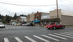
Most of the town's 500 homes were built in the 1920s on land owned by the railroad. The 1920s-era commercial district consisted of four square blocks, of which about one dozen buildings remain as representatives of western frontier commercial architecture. Roslyn has many examples of Victorian elegance in its surviving buildings, as well as simple miner's shacks. The town of Roslyn was listed on the National Register of Historic Places in 1978. [9] Recently, Roslyn became a Certified Local Government. Its Historic Preservation Commission restored the Roslyn Cafe, a local landmark.

Roslyn's railroad tracks have been removed and replaced by the Coal Mines Trail which runs from Cle Elum through Roslyn to Ronald. A walk on the trail affords visitors a look at the remains of Roslyn's mines and railroad depot site. The Roslyn Museum houses an extensive collection of photos and mining memorabilia, and features an exhibit on Roslyn's unique ethnic cemeteries.

Most recently, recreation and tourism have become the chief drivers of the economy. The business community has worked to bring in more visitors through annual festivals, including the Manly Man Festival in June, the Pioneer Days Picnic, and a Coal Mining Festival associated with Coal Mining History Week each August.

Knights of Labor Strike of 1888 and African American migration

The Brick Tavern is the oldest continuously operating tavern in the state, and was featured prominently in Northern Exposure (1990 to 1995). Roslyn was used as the site for filming the fictitious town of Cicely, Alaska, in the hit CBS television series. Roslyn-2.jpg
The Brick Tavern is the oldest continuously operating tavern in the state, and was featured prominently in Northern Exposure (1990 to 1995). Roslyn was used as the site for filming the fictitious town of Cicely, Alaska, in the hit CBS television series.

Tensions between management and labor in the Roslyn mines began spilling over in the summer of 1888, when management laid off a number of labor union workers who were petitioning for eight-hour work days and higher wages. These layoffs led to a labor strike by the Knights of Labor, which shut down the mines. Northwest Coal Company, which conducted mining operations at Mine No. 3, a few miles away in nearby Ronald, responded by recruiting strikebreakers. This included 50 black laborers from the East and Midwest who were transported by train with almost 40 private armed guards. The recruitment of these armed forces raised the interest of Territorial Governor Eugene Semple when he heard that they harassed area residents calling themselves U.S. Marshals. This was considered a paramilitary challenge to Washington Territory authority and Semple ordered the local sheriff to disperse the unit. [10]

Semple visited Roslyn to investigate Northwest Coal Company's practices and condemned the company for hiring a private militia on suppositions that the white strikers would attack black laborers and overpower police forces. Semple's report describes the residents as "intelligent" and "law-abiding," and the company's suppositions as erroneous. He did not intervene on the labor disputes, and strikers continued to lose ground in negotiations. [10]

In a span of two years, the company recruited more than 300 black laborers from Virginia, North Carolina, and Kentucky. Many relocated with families, and this migration was the largest increase in the African-American population of Washington Territory up until that time. Sheriff Packwood of Kittitas County reported to Semple that relations between out-of-work white workers and the black population were strained with potential to turn violent. However, after the strike broke tensions reduced, and whites reconciled with working along black miners. As the regional coal industry boomed, competition for employment reduced, and eventually workers organized as equals with United Mine Workers. [11]

The Coal Miners' Memorial in Roslyn. Note the radio station film set from the Northern Exposure television series in the background. Roslyn-miner-memorial-and-KBHR.JPG
The Coal Miners' Memorial in Roslyn. Note the radio station film set from the Northern Exposure television series in the background.

Mine accident of 1892

In 1892, 45 miners were killed in an explosion at Mine No. 1 near Roslyn, the deadliest mining accident in Washington history.

1892 Ben E. Snipes and Co. bank robbery

On September 24, 1892, a group of five bandits, known criminals and affiliates of Butch Cassidy, held up the Roslyn branch of the Ellensburg-based Ben Snipes Bank. Two of the men stood guard with the horses while the other three went inside. One of the men approached the cashier asking for what ever was in the already open vault. The other two men kept the customers in the store quiet, one of them was Dr. Lyon who would later be murdered and the case never solved. The five men rode away with $5,000 or $10,000, depending on the source. It is thought that the men were expecting the coal miner's pay, $40,000 coming from Tacoma, would have been held in the bank. However, the money was sent directly to the coal company.

The sheriff and his posse soon chased after the men and into the hills of Teanaway. In November 1892, three men were brought into the jail and were asked to be identified by the witnesses of the robbery. Cal, Kimize, and Zachary Hale were taken in and arrested. Cal was the only one of the three men to be charged and found guilty of the crime.

A couple of months later, the Kittitas County Courts, received a letter from Utah, telling them that they had convicted the wrong man. Cal Hale was set free and the search for Tom, George, William and Fred McCarthy, as well as Ras Lewis (alias Ras Christiansen and Matt Warner). In April 1893, a posse traveled down into Oregon looking for these bandits. George and William went with the men without a fight. Tom, Fred and Ras took off and were soon lost. Later that month the Yakima County Attorney received a letter from Rosa Lewis, Ras Lewis' wife, stating that she knew that the men had done it and she was tired of her husband's battle with the law. Soon after the Sheriff and his posse went to the cabin at the "7 U Ranch", owned by Fred Beezley, that Ras and his wife were leasing.

All five men were eventually taken into custody and tried. George and Ras attempted to break free and ran around the city of Ellensburg until the sheriff was able to detain them. There were two separate trials that would take place. This first was dismissed due to being a mistrial and the second one ending without any answers. It is rumored that the lawyer simply asked the men to tell them where the money had been stored. Court records state that they simply did not have witnesses that were able to testify.

The trials and all other fees associated with bringing justice to the county nearly bankrupted Kittitas County. Ras Lewis changed his name to Matt Warner, he was involved in a shoot out in 1895 and was arrested, serving 4 years. After that he became a Justice of the Peace and Sheriff of Price, Utah until his death in 1938.

Several of the McCartys were later killed during an attempted bank robbery in Colorado. [12]

African American population

In 1890, Roslyn's African American population was 22%, one of the highest in the state. [10] Black fraternal organization lodges and civic institutions were established, including Prince Hall Masons, Knights of Pythias of North America, South America, Europe, Asia, Africa and Australia, Prince Hall Order of the Eastern Star, Daughters of Tabernacle, and African Methodist Episcopal Church. The Black population began to decline after the mines closed in 1963, and by the early 1970s only the Craven family remained. William Craven was elected mayor of Roslyn in 1976, and was the first African American mayor in the state of Washington. [11]

The Roslyn Black Pioneers was established by Ethel Florence Craven to preserve and promote black history in Washington. The organization received a grant from Humanities Washington to build educational floats for Washington parades. [13]

Roslyn's ethnic cemeteries

Roslyn's historic cemetery is divided into 26 ethnic plots like the one depicted here. Roslyn-Slovak-Cemetery-P5270062.jpg
Roslyn's historic cemetery is divided into 26 ethnic plots like the one depicted here.

The Roslyn Cemetery is composed of 26 separate but adjacent cemetery plots, reflecting the diversity of early immigrant society. It was placed on the National Register of Historic Places in 1978. Clustered on 15 acres (61,000 m2) of woods and hills above the town's main street, the land was donated by or purchased from the Northern Pacific Company by fraternal, ethnic and civic organizations for burial of their deceased members.

The Independent Order of Odd Fellows (IOOF), Knights of Pythias Lodge, Soloka Lodge, Wanapum Tribe 28, Improved Order of Redmen, Cacciatori d’Africa (literally Hunters of Africa – an Italian lodge), Croatian Fraternal Union Lodge No. 56, SNF Lodge No. 79 (Serbian), St. Barbara Lodge No. 39 (Greek Catholic), and Dr. David Starcevich Lodge No. 56 (Croatian) are among the organizations and ethnicities represented at the cemetery. At least 24 nationalities are represented among the nearly 5,000 graves.

Post mining era

Lake Cle Elum near Roslyn is a year-round recreational destination. Cle Elum Lake (533523210).jpg
Lake Cle Elum near Roslyn is a year-round recreational destination.

Although Roslyn clings to its coal mining and timber harvesting past, it has become a tourist and recreation destination. Tourism to the town received a boost when it was featured as the filming location for The Runner Stumbles and Northern Exposure . The town's proximity to Seattle makes it a popular destination for recreational travelers.

As many as 2,000 luxury homes are being developed nearby, potentially adding to the old town's population. Forests once owned and managed by Plum Creek Timber Company have been sold to two development companies, which are in the process of developing an extensive golf course community with houses and condominiums on the boundary of Roslyn. The new community is called Suncadia. As in similar small towns being transformed by large-scale capital projects and outside investment, these changes are expected to significantly improve Roslyn. [14]

However, some community members in Roslyn were concerned about the effects a Master Planned Resort [15] would have on their community's economy and ecology. A Roslyn-based citizen group called RIDGE engaged Suncadia's owners in litigation to mitigate the effects of the resort. RIDGE and MountainStar Resort Development—who owned the land at the time—engaged in negotiations and signed the RIDGE Settlement Agreement in 2001. Though the Settlement Agreement was eventually dissolved in 2013 when Kittitas County Judge Scott R. Sparks terminated the Agreement and all remaining claims, [16] the Settlement Agreement was successful in some of their mitigations such as Suncadia's purchase and donation of the Roslyn Urban Forest to the city of Roslyn and the Suncadia Resort being developed and built using labor paid Washington state's prevailing wage. [17]

Roslyn's railroad tracks have been removed and replaced by the Coal Mines Trail which runs from Cle Elum through Roslyn to Ronald. A walk on the trail affords visitors a look at the remains of Roslyn's mines and railroad depot site. The Roslyn Museum houses an extensive collection of photos and mining memorabilia, and features an exhibit on Roslyn's unique ethnic cemeteries.

Most recently, recreation and tourism have become the chief drivers of the economy. The business community has worked to bring in more visitors through annual festivals, including the Manly Man Festival in June, the Pioneer Days Picnic, and a Coal Mining Festival associated with Coal Mining History Week each August.

Geography

Roslyn is located at 47°13′30″N121°0′11″W / 47.22500°N 121.00306°W / 47.22500; -121.00306 (47.225091, -121.002985). [21] It is 83.0 mi (133.6 km) – about 1 hour 25 mins east-south-east from Seattle, Washington

According to the United States Census Bureau, the city has a total area of 4.37 square miles (11.32 km2), all of it land. [22]

Demographics

Historical population
CensusPop.Note
1890 1,484
1900 2,78687.7%
1910 3,12612.2%
1920 2,673−14.5%
1930 2,063−22.8%
1940 1,743−15.5%
1950 1,537−11.8%
1960 1,283−16.5%
1970 1,031−19.6%
1980 938−9.0%
1990 869−7.4%
2000 1,01717.0%
2010 893−12.2%
2019 (est.)958 [3] 7.3%
U.S. Decennial Census [23]

2010 census

As of the census [2] of 2010, there were 893 people, 437 households, and 224 families residing in the city. The population density was 204.3 inhabitants per square mile (78.9/km2). There were 648 housing units at an average density of 148.3 per square mile (57.3/km2). The racial makeup of the city was 95.1% White, 0.4% African American, 1.1% Native American, 0.6% Asian, 0.1% from other races, and 2.7% from two or more races. Hispanic or Latino of any race were 2.7% of the population.

There were 437 households, of which 22.2% had children under the age of 18 living with them, 39.8% were married couples living together, 8.5% had a female householder with no husband present, 3.0% had a male householder with no wife present, and 48.7% were non-families. 39.6% of all households were made up of individuals, and 13.1% had someone living alone who was 65 years of age or older. The average household size was 2.04 and the average family size was 2.73.

The median age in the city was 43.2 years. 18.4% of residents were under the age of 18; 5.2% were between the ages of 18 and 24; 29.1% were from 25 to 44; 32.2% were from 45 to 64; and 15.1% were 65 years of age or older. The gender makeup of the city was 52.6% male and 47.4% female.

2000 census

As of the census of 2000, there were 1,017 people, 467 households, and 249 families residing in the city. The population density was 82.3/km2 (213.0/sq mi).

There were 623 housing units at an average density of 130.5 per square mile (50.4/km2). The racial makeup of the city was 95.87% White, 0.79% African American, 1.38% Native American, 0.39% Pacific Islander, and 1.57% from two or more races. Hispanic or Latino of any race were 1.38% of the population. Identification as to ethnicity in 2000 was as follows: 17.9% were of German ancestry, 15.9% English, 10.3% Irish, 7.1% Norwegian, 6.6% American, 5.7% Croatian, 5.7% Scotch-Irish, and 5.1% Italian.

There were 467 households, out of which 25.7% had children under the age of 18 living with them, 43.9% were married couples living together, 6.2% had a female householder with no husband present, and 46.5% were non-families. 37.9% of all households were made up of individuals, and 18.2% had someone living alone who was 65 years of age or older. The average household size was 2.18 and the average family size was 2.89.

In the city, the population was spread out, with 21.9% under the age of 18, 6.5% from 18 to 24, 26.9% from 25 to 44, 26.6% from 45 to 64, and 18.0% who were 65 years of age or older. The median age was 42 years. For every 100 females, there were 96.0 males. For every 100 females age 18 and over, there were 90.9 males.

The median income for a household in the city was $35,313, and the median income for a family was $45,179. Males had a median income of $32,379 versus $25,625 for females. The per capita income for the city was $18,412. About 8.2% of families and 12.6% of the population were below the poverty line, including 9.1% of those under age 18 and 15.5% of those age 65 or over.

Points of interest in Roslyn

Roslyn Historic District

Roslyn Historic District
Morning, Roslyn, WA.jpg
Old storefronts in historic district
LocationWA 2E, Roslyn, Washington
Area340 acres (140 ha)
Built1890 (1890)
NRHP reference No. 78002760 [25]
Added to NRHPFebruary 14, 1978

The Roslyn Historic District consists of the town of Roslyn as of 1977 which corresponds to the 1914 plat map, as well as the cluster of 26 cemeteries southwest of the town and a 58 acres (23 ha) open space, bisected by the tracks of the Roslyn Branch of the Northern Pacific Railroad, east of the town. [26]

Commercial buildings contributing to the historical designation include:

Further reading

Related Research Articles

<span class="mw-page-title-main">Kittitas County, Washington</span> County in Washington, United States

Kittitas County is a county located in the U.S. state of Washington. At the 2020 census, its population was 44,337. Its county seat and largest city is Ellensburg. The county was created in November 1883 when it was carved out of Yakima County. Kittitas County comprises the Ellensburg, Washington, Micropolitan Statistical Area.

<span class="mw-page-title-main">Lafayette, Colorado</span> City in Colorado, United States

The City of Lafayette is a home rule municipality located in southeastern Boulder County, Colorado, United States. The city population was 30,411 at the 2020 United States Census.

<span class="mw-page-title-main">Madrid, New Mexico</span> CDP in New Mexico, United States

Madrid is a census-designated place (CDP) in Santa Fe County, New Mexico, United States. It is part of the Santa Fe, New Mexico Metropolitan Statistical Area. The population was 149 at the 2000 census and 204 in 2010. Today, Madrid has become an artists' community with galleries lining New Mexico State Road 14. It retains remnants of its history with the Mineshaft Tavern and the Coal Mine Museum.

<span class="mw-page-title-main">Cle Elum, Washington</span> City in Washington, United States

Cle Elum is a city in Kittitas County, Washington, United States. The population was 1,872 at the 2010 census. About 84 miles (135 km) by car from Seattle, Cle Elum is a popular area for camping and outdoor activities. It is also unofficially considered the starting point of Eastern Washington when driving east on I-90 from Seattle, although this is somewhat arbitrary since many consider either the town of Easton, anywhere east of Keechelus Lake, or the wildlife crossing bridge over I-90 to be the starting point.

<span class="mw-page-title-main">Ronald, Washington</span> Census-designated place in Washington, United States

Ronald is an unincorporated community and census-designated place (CDP) in Kittitas County, Washington, United States. The population was 308 at the 2010 census.

<span class="mw-page-title-main">South Cle Elum, Washington</span> Town in Washington, United States

South Cle Elum is a town in Kittitas County, Washington, United States. The population was 532 at the 2010 census.

<span class="mw-page-title-main">Thorp, Washington</span> Census-designated place in Washington, United States

Thorp is an unincorporated community and census-designated place (CDP) in Kittitas County, Washington, United States. In 2015, the population was 317 according to statistics compiled by Data USA.

<span class="mw-page-title-main">Cle Elum River</span> River in Washington, United States

The Cle Elum River is a tributary of the Yakima River, approximately 28 miles (45 km) long in the U.S. state of Washington. A Northern Pacific Railway station at the future site of the city of Cle Elum, Washington was named Clealum after the Kittitas name Tie-el-Lum, meaning "swift water", referring to the Cle Elum River. In 1908, Clealum was altered to Cle Elum. This spelling came to be used for the river as well. Some maps in the 1850s also have the river labeled as Samahma River.

New Waterford is an urban community in the Cape Breton Regional Municipality of Nova Scotia, Canada.

Suncadia is an unincorporated community and resort in Kittitas County, Washington, covering an area of 6,300 acres (25.5 km2). It is located approximately 80 miles (130 km) east of Seattle in the Cascade Mountains between Roslyn, Cle Elum, and the Mountains to Sound Greenway section of Interstate 90.

<span class="mw-page-title-main">Washington State Route 903</span> Highway in Washington

State Route 903 (SR 903) is a 10.06-mile-long (16.19 km) state highway located entirely in Kittitas County, Washington, United States. The highway links Lake Cle Elum to Roslyn, Cle Elum and SR 970, which provides access to Interstate 90. The highway has existed as a numbered highway since at least 1939, however a highway linking Lake Cle Elum to Cle Elum has existed since 1897. The Washington State Department of Transportation (WSDOT) had previously considered turning control of the highway over to Kittitas County, however this never happened, and WSDOT continues to maintain the highway.

Nortonville is an unincorporated ghost town in Contra Costa County, California. It was located on Kirker Creek 5.5 miles (9 km) north-northeast of Mount Diablo, at an elevation of 801 feet.

<span class="mw-page-title-main">South Cle Elum Yard</span> United States historic place

The Chicago, Milwaukee, St. Paul and Pacific Railroad South Cle Elum Rail Yard located in South Cle Elum, Washington, was a division point on the Chicago, Milwaukee, St. Paul and Pacific Railroad's Coast Division. It was established by the railroad in 1909 during construction of its "Pacific Extension".

The Consolidation Coal Company (CCC) was founded in 1875 in Iowa and purchased by the Chicago and North Western Railroad in 1880 in order to secure a local source of coal. The company operated in south central Iowa in Mahaska and Monroe counties until after World War I. Exhaustion of some resources, competition from overseas markets, and other changes led to the company's closing down its mines and leaving its major planned towns by the late 1920s. The CCC worked at Muchakinock in Mahaska County until the coal resources of that area were largely exhausted. In 1900, the company purchased 10,000 acres (40 km2) in southern Mahaska County and northern Monroe County, Iowa.

Cambria (1889–1928) is a ghost town located in the Black Hills of Weston County, Wyoming, United States. It was a successful coal mining town for decades.

The Northern Kittitas County Tribune is a weekly newspaper based in Cle Elum, Washington, United States. It was founded in 1953 and publishes on Thursdays with a circulation of approximately 3,650. In 1962, it purchased the Cle Elum Miner Echo, which had been publishing since 1928, and suspended its publication; it took over the Miner Echo's building for its own publication. The newspaper is owned by Oahe Publishing.

The Black Diamond Coal Mining Company was formed in 1861, consolidating the Cumberland and Black Diamond coal mines in the region of Mount Diablo, in Contra Costa County, California. During its years of operation as a mining company, it established three towns: Nortonville, California, Southport, Oregon, and Black Diamond, Washington. The company's mines in California and its settlement of Nortonville later became part of the Black Diamond Mines Regional Park and a California Historical Landmark. Several railroad lines were built in California and Washington to support the company's mines, and the company operated numerous ships to transport its coal. As the mines played out and petroleum became the more common source of energy, the company closed its mines and transitioned into real estate as the Southport Land and Commercial Company.

<span class="mw-page-title-main">Northwestern Improvement Company Store</span> Historic building in Roslyn, Washington

Northwestern Improvement Company Store, also known as the NWI Building, is a historic building in Roslyn, Washington, the sole structure remaining from the days of the Roslyn Coal Field. It was added to the National Register of Historic Places in 1973. In the 1990s, the Northwestern Improvement Company Store building was one of the locations used in the TV series Northern Exposure.

The Martin Ski Dome was a ski area located in Martin, Washington.

<span class="mw-page-title-main">Roslyn Historical Cemeteries</span>

The Roslyn Historical Cemeteries is a collection of 26 separate cemeteries in Roslyn, WA. Situated on 15 acres, the cemeteries include an estimated 5,000 graves and represent at least 24 different nationalities.

References

  1. "2019 U.S. Gazetteer Files". United States Census Bureau. Retrieved August 7, 2020.
  2. 1 2 "U.S. Census website". United States Census Bureau . Retrieved December 19, 2012.
  3. 1 2 "Annual Estimates of the Resident Population for Incorporated Places in Washington: April 1, 2010 to July 1, 2019". United States Census Bureau. May 2020. Retrieved May 27, 2020.
  4. "Roslyn". Geographic Names Information System . United States Geological Survey, United States Department of the Interior.
  5. "2010 Census Redistricting Data (Public Law 94-171) Summary File". American FactFinder. United States Census Bureau . Retrieved September 20, 2012.[ dead link ]
  6. Majors, Harry M. (November 1, 1975). Exploring Washington. Van Winkle Publishing Co. pp. 89–90. ISBN   978-0-918664-00-6.
  7. Goodloe, Trevor. "Roslyn, Washington (1886-- )". BlackPast.org. Retrieved January 19, 2018.
  8. "National Register Information System  Northwestern Improvement Company Store (#73001881)". National Register of Historic Places . National Park Service. November 2, 2013. Retrieved September 9, 2017.
  9. "National Register Information System  Roslyn Historic District (#78002760)". National Register of Historic Places . National Park Service. November 2, 2013. Retrieved September 9, 2017.
  10. 1 2 3 "Roslyn coalminers strike, precipitating the importation of black miners, on August 17, 1888". www.historylink.org. Retrieved February 14, 2019.
  11. 1 2 "Roslyn, Washington (1886-- ) • BlackPast". BlackPast. March 15, 2008. Retrieved February 14, 2019.
  12. Lyman, W.D. (1919). History of the Yakima Valley, Washington, Comprising Yakima, Kittitas and Benton Counties. The S.J. Clarke Publishing Co. pp.  762–777.
  13. "Roslyn Black Pioneers Used Parade Floats to Educate and Entertain". Humanities Washington. November 14, 2013. Retrieved February 14, 2019.
  14. The Economist, Volume 379, Number 8481, pp. 30-31, June 10, 2006
  15. Master Planned Resort, Revised Code of Washington
  16. Johnston, Mike. "Suncadia Pact Ended by Ruling". Daily Record, May 30, 2013
  17. RIDGE Records. 1923-2015. 9.31 cubic feet (9 boxes). At the Labor Archives of Washington, University of Washington Libraries Special Collections.
  18. "The World Famous Brick Saloon".
  19. Hoang, Mai. "Did you Know? Roslyn lives on, in real life and on TV". Yakima Herald-Republic. Retrieved December 21, 2019.
  20. Muir, Pat (October 5, 2014). "Roslyn hopes new TV show brings 15 more minutes of fame". Yakima Herald . Archived from the original on November 2, 2014. Retrieved November 1, 2014.
  21. "US Gazetteer files: 2010, 2000, and 1990". United States Census Bureau. February 12, 2011. Retrieved April 23, 2011.
  22. "US Gazetteer files 2010". United States Census Bureau. Archived from the original on January 25, 2012. Retrieved December 19, 2012.
  23. United States Census Bureau. "Census of Population and Housing" . Retrieved July 21, 2014.
  24. The Brick Tavern claims the title of the oldest continuously operating tavern in the state of Washington, opening in 1889 and operating under a single name since 1898. According to its owners, the Bluebird Inn in Bickleton, Washington, is the state's oldest functioning tavern having first opened in 1882; however, it has operated under numerous names and has not been continuously licensed to operate since its founding.
  25. "National Register Information System". National Register of Historic Places . National Park Service. November 2, 2013.
  26. Florence K. Lentz (January 1977). "National Register of Historic Places Inventory/Nomination: Roslyn Historic District". National Park Service . Retrieved December 31, 2019. With 15 accompanying pictures