Ellensburg, Washington

Last updated

Ellensburg, Washington
2008-1019-01-Ellensburg01.jpg
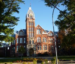
The historic Davidson Building, completed in 1890
City of Ellensburg - Logo.png
Kittitas County Washington Incorporated and Unincorporated areas Ellensburg Highlighted.svg
Location of Ellensburg, Washington
Coordinates: 46°59′42″N120°32′56″W / 46.995°N 120.549°W / 46.995; -120.549
CountryUnited States
State Washington
County Kittitas
Incorporated November 26, 1883
Government
  Type Council–manager
  City ManagerHeidi Behrends Cerniwey
  MayorNancy Lillquist [1]
Area
[2]
   City 7.81 sq mi (20.23 km2)
  Land7.74 sq mi (20.04 km2)
  Water0.08 sq mi (0.20 km2)
Elevation
1,542 ft (470 m)
Population
 (2020) [3]
   City 18,666
  Estimate 
(2021) [4]
19,596
  Density2,728.93/sq mi (1,053.68/km2)
   Metro
45,499 (US: 256th)
Time zone UTC-8 (PST)
  Summer (DST) UTC-7 (PDT)
ZIP codes
98926
Area code 509
FIPS code 53-21240
GNIS feature ID1519305 [5]
Website ci.ellensburg.wa.us

Ellensburg is a city in and the county seat of Kittitas County, Washington, United States. It is located just east of the Cascade Range near the junction of Interstate 90 and Interstate 82. The population was 18,666 at the 2020 census. [3] and was estimated to be 19,596 in 2021. [4]

Contents

The city is located along the Yakima River in the Kittitas Valley, an agricultural region that extends east towards the Columbia River. The valley is a major producer of timothy hay, which is processed and shipped internationally. Ellensburg is also the home of Central Washington University (CWU).

Ellensburg, originally named Ellensburgh for the wife of town founder John Alden Shoudy, was founded in 1871 and grew rapidly in the 1880s following the arrival of the Northern Pacific Railway. The city was once a leading candidate to become the state capital of Washington, but its campaign was scuppered by a major fire in 1889.

History

Barge Hall at Central Washington University 2008-1019-02-CentralWashingtonUniversity.jpg
Barge Hall at Central Washington University

John Alden Shoudy arrived in the Kittitas Valley in 1871 and purchased a small trading post from Andrew Jackson "A.J." Splawn, called "Robber's Roost". Robber's Roost was the first business in the valley, aside from the early trading that occurred among Native Americans, cattle drivers, trappers, and miners. A small stone monument to Robber's Roost with a placard can be found at its original location, present-day 3rd Avenue, just west of Main Street near the alley. [6]

Shoudy named the new town after his wife, Mary Ellen, thus officially starting the city of Ellensburgh around 1872. Shoudy had not been the first settler nor the first business person in the Kittitas Valley, but he was responsible for platting the city of Ellensburgh in the 1870s and also named the streets in the downtown district. Ellensburgh was officially incorporated on November 26, 1883. In 1894, the final -h was dropped under standardization pressure from the United States Postal Service and Board of Geography Names. [7] Ellensburg was an early center of commerce in Washington and was among the first cities in the state to have electrical service.

The city launched a bid to become Washington state's capital in 1889, preparing a site in the Capital Hill neighborhood for government offices. On July 4 that year, however, a major fire destroyed much of the downtown area and stalled the campaign, which resumed with a series of referendums, in which Washington voters chose Olympia. [8] The state legislature selected Ellensburg as the location for the State Normal School (now Central Washington University). [9]

There were several early newspapers in Ellensburg. The Daily Record, which started in 1909, is the publication which serves the city and county today. [10] Concerns over the state of Ellensburg's historic downtown led to the formation of the Ellensburg Downtown Association to work on revitalizing the area. [11]

Arts and culture

The City of Ellensburg has several local art museums and galleries:

Events

Geography

According to the United States Census Bureau, the city has a total area of 6.97 square miles (18.05 km2), of which 6.92 square miles (17.92 km2) is land and 0.05 square miles (0.13 km2) is water. [26]

Climate

Owing to the strong Cascade rain shadow, Ellensburg experiences a typical Intermountain cool semi-arid climate (Köppen BSk). The hottest temperature recorded in Ellensburg was 110 °F (43.3 °C) on July 26, 1928, while the coldest temperature recorded was −31 °F (−35.0 °C) on December 12, 1919. [27]

Climate data for Ellensburg, Washington, 1991–2020 normals, extremes 1892–present
MonthJanFebMarAprMayJunJulAugSepOctNovDecYear
Record high °F (°C)64
(18)
66
(19)
80
(27)
94
(34)
99
(37)
108
(42)
110
(43)
107
(42)
98
(37)
87
(31)
71
(22)
65
(18)
110
(43)
Mean maximum °F (°C)60.7
(15.9)
61.6
(16.4)
69.4
(20.8)
77.4
(25.2)
88.0
(31.1)
95.2
(35.1)
102.6
(39.2)
101.0
(38.3)
92.6
(33.7)
80.0
(26.7)
66.5
(19.2)
59.9
(15.5)
104.2
(40.1)
Average high °F (°C)35.0
(1.7)
42.6
(5.9)
52.1
(11.2)
60.1
(15.6)
69.3
(20.7)
75.6
(24.2)
84.8
(29.3)
84.5
(29.2)
76.1
(24.5)
61.5
(16.4)
45.5
(7.5)
35.0
(1.7)
60.2
(15.7)
Daily mean °F (°C)27.6
(−2.4)
32.5
(0.3)
39.8
(4.3)
46.9
(8.3)
55.7
(13.2)
61.9
(16.6)
69.2
(20.7)
68.2
(20.1)
59.8
(15.4)
47.5
(8.6)
35.7
(2.1)
27.7
(−2.4)
47.7
(8.7)
Average low °F (°C)20.2
(−6.6)
22.4
(−5.3)
27.6
(−2.4)
33.7
(0.9)
42.1
(5.6)
48.2
(9.0)
53.6
(12.0)
51.9
(11.1)
43.4
(6.3)
33.5
(0.8)
25.9
(−3.4)
20.3
(−6.5)
35.2
(1.8)
Mean minimum °F (°C)11.7
(−11.3)
15.8
(−9.0)
23.1
(−4.9)
28.5
(−1.9)
33.5
(0.8)
41.2
(5.1)
47.2
(8.4)
46.0
(7.8)
37.8
(3.2)
25.7
(−3.5)
18.8
(−7.3)
12.1
(−11.1)
3.7
(−15.7)
Record low °F (°C)−29
(−34)
−23
(−31)
−5
(−21)
14
(−10)
18
(−8)
30
(−1)
30
(−1)
29
(−2)
16
(−9)
9
(−13)
−17
(−27)
−31
(−35)
−31
(−35)
Average precipitation inches (mm)1.19
(30)
0.82
(21)
0.80
(20)
0.63
(16)
0.81
(21)
0.55
(14)
0.31
(7.9)
0.18
(4.6)
0.33
(8.4)
0.82
(21)
1.10
(28)
1.45
(37)
8.99
(228.9)
Average snowfall inches (cm)6.9
(18)
2.6
(6.6)
0.7
(1.8)
0.0
(0.0)
0.0
(0.0)
0.0
(0.0)
0.0
(0.0)
0.0
(0.0)
0.0
(0.0)
trace3.4
(8.6)
7.5
(19)
21.1
(54)
Average extreme snow depth inches (cm)2.4
(6.1)
2.6
(6.6)
1.0
(2.5)
0.0
(0.0)
0.0
(0.0)
0.0
(0.0)
0.0
(0.0)
0.0
(0.0)
0.0
(0.0)
0.0
(0.0)
0.7
(1.8)
3.0
(7.6)
4.9
(12)
Average precipitation days (≥ 0.01 in)9.57.47.86.67.46.02.52.33.07.19.210.679.4
Average snowy days (≥ 0.1 in)4.91.90.60.00.00.00.00.00.00.01.86.215.4
Source 1: NOAA [28] [29]
Source 2: National Weather Service [27]

Demographics

Historical population
CensusPop.Note
1870 150
1880 1500.0%
1890 2,7681,745.3%
1900 1,737−37.2%
1910 4,209142.3%
1920 3,967−5.7%
1930 4,62116.5%
1940 5,94428.6%
1950 8,43041.8%
1960 8,6252.3%
1970 13,56857.3%
1980 11,752−13.4%
1990 12,3615.2%
2000 15,41424.7%
2010 18,17417.9%
2020 18,6662.7%
2021 (est.)19,596 [4] 5.0%
U.S. Decennial Census [30]
2020 Census [3]

2010 census

As of the census [31] of 2010, there were 18,174 people, 7,301 households, and 2,889 families living in the city. The population density was 2,626.3 inhabitants per square mile (1,014.0/km2). There were 7,867 housing units at an average density of 1,136.8 per square mile (438.9/km2). The racial makeup of the city was 85.7% White, 1.5% African American, 1.0% Native American, 3.2% Asian, 0.2% Pacific Islander, 4.6% from other races, and 3.7% from two or more races. Hispanic or Latino of any race were 9.7% of the population.

There were 7,301 households, of which 19.3% had children under the age of 18 living with them, 28.2% were married couples living together, 8.2% had a female householder with no husband present, 3.1% had a male householder with no wife present, and 60.4% were non-families. 35.1% of all households were made up of individuals, and 9.6% had someone living alone who was 65 years of age or older. The average household size was 2.16 and the average family size was 2.86.

The median age in the city was 23.5 years. 14.2% of residents were under the age of 18; 41.2% were between the ages of 18 and 24; 21.8% were from 25 to 44; 13.9% were from 45 to 64; and 8.9% were 65 years of age or older. The gender makeup of the city was 50.1% male and 49.9% female.

2000 census

As of the census of 2000, there were 15,414 people, 6,249 households, and 2,649 families living in the city. The population density was 2,338.9 people per square mile (903.1 people/km2). There were 6,732 housing units at an average density of 1,021.5 per square mile (394.4/km2). The racial makeup of the city was 88.07% White, 1.17% Black or African American, 0.95% Native American, 4.09% Asian, 0.16% Pacific Islander, 2.86% from other races, and 2.69% from two or more races. 6.33% of the population were Hispanic or Latino of any race.

There were 6,249 households, of which 20.8% had children under the age of 18 living with them, 31.4% were married couples living together, 8.1% had a female householder with no husband present, and 57.6% were non-families. 35.5% of all households were made up of individuals, and 9.1% had someone living alone who was 65 years of age or older. The average household size was 2.12 and the average family size was 2.84.

In the city, the population was spread out, with 15.8% under the age of 18, 39.3% from 18 to 24, 22.7% from 25 to 44, 12.8% from 45 to 64, and 9.4% who were 65 years of age or older. The median age was 24 years. For every 100 females, there were 95.0 males. For every 100 females age 18 and over, there were 93.1 males.

The median income for a household in the city was $20,034, and the median income for a family was $37,625. Males had a median income of $31,022 versus $22,829 for females. The per capita income for the city was $13,662. About 18.8% of families and 34.3% of the population were below the poverty line, including 29.0% of those under age 18 and 11.2% of those age 65 or over.

Politics and government

The City of Ellensburg uses the Manager/Council form of government with a City Manager hired by the City Council. The seven-member City Council is elected at large and serve 4-year terms. The City Council elects a Mayor and Deputy Mayor from the council to serve 2-year terms.[ citation needed ]

On the state legislative level, Ellensburg is in the 13th district. As of May, 2018, its state senator is Republican Judy Warnick, and its two state representatives are Republicans Alex Ybarra and Tom Dent. On the congressional level, Ellensburg is located in Washington's 8th congressional district and is represented by Democrat Kim Schrier.

Media

Kittitas County is served by the Daily Record , a newspaper published in Ellensburg five days a week.

The city maintains its own public library, which opened on January 20, 1910, using funds donated by Andrew Carnegie. [32]

Education

Higher education

Public schools

Public schools are operated by Ellensburg School District 401. The district includes one high school (Ellensburg High School), one middle school, and four elementary schools. [33]

Notable people

Related Research Articles

<span class="mw-page-title-main">Yakima, Washington</span> City in Washington, United States

Yakima is a city in, and the county seat of, Yakima County, Washington, United States, and the state's 11th most populous city. As of the 2020 census, the city had a total population of 96,968 and a metropolitan population of 256,728. The unincorporated suburban areas of West Valley and Terrace Heights are considered a part of greater Yakima.

<span class="mw-page-title-main">Yakima County, Washington</span> County in Washington, United States

Yakima County is a county in the U.S. state of Washington. As of the 2020 census, its population was 256,728. The county seat and largest city is Yakima. The county was formed out of Ferguson County in January 1865 and is named for the Yakama tribe of Native Americans.

<span class="mw-page-title-main">Kittitas County, Washington</span> County in Washington, United States

Kittitas County is a county located in the U.S. state of Washington. At the 2020 census, its population was 44,337. Its county seat and largest city is Ellensburg. The county was created in November 1883 when it was carved out of Yakima County. Kittitas County comprises the Ellensburg, Washington, Micropolitan Statistical Area.

<span class="mw-page-title-main">Grant County, Washington</span> County in Washington, United States

Grant County is a county located in the U.S. state of Washington. As of the 2020 census, the population was 99,123. The county seat is Ephrata, and the largest city is Moses Lake. The county was formed out of Douglas County in February 1909 and is named for U.S. President Ulysses S. Grant.

<span class="mw-page-title-main">Chelan County, Washington</span> County in Washington, United States

Chelan County is a county in the U.S. state of Washington. As of the 2020 census, its population was 79,074. The county seat and largest city is Wenatchee. The county was created out of Okanogan and Kittitas Counties on March 13, 1899. It derives its name from a Chelan Indian word meaning "deep water," likely a reference to 55-mile (89 km)-long Lake Chelan, which reaches a maximum depth of 1,486 feet (453 m).

<span class="mw-page-title-main">Dayton, Iowa</span> City in Iowa, United States

Dayton is a city in Webster County, Iowa, United States. The population was 772 at the time of the 2020 census.

<span class="mw-page-title-main">Longford, Kansas</span> City in Clay County, Kansas

Longford is a city in Clay County, Kansas, United States. As of the 2020 census, the population of the city was 73.

<span class="mw-page-title-main">Ritzville, Washington</span> City in Washington, United States

Ritzville is a city in Adams County, Washington, United States. The population was 1,767 at the 2020 census. It is the county seat of Adams County. The city is part of the Othello, WA Micropolitan Area, which comprises all of Adams County, and is part of the larger Moses Lake-Othello, WA Combined Statistical Area.

<span class="mw-page-title-main">Moses Lake North, Washington</span> Census-designated place in Washington, United States

Moses Lake North is a census-designated place (CDP) in Grant County, Washington, United States. The population was 4,050 at the 2020 census.

<span class="mw-page-title-main">Des Moines, Washington</span> City in Washington, United States

Des Moines is a city in King County, Washington, United States. The population was 32,888 as of the 2020 census. The city is located on the east shore of Puget Sound, near the center of the Seattle metropolitan area. It is bordered by the suburbs of Federal Way to the south, Kent to the east, SeaTac to the northeast, Burien to the north, and Normandy Park to the northwest.

<span class="mw-page-title-main">Duvall, Washington</span> City in Washington, United States

Duvall is a city in King County, Washington, United States, located on SR 203 halfway between Monroe and Carnation. The population was 8,034 at the 2020 census.

<span class="mw-page-title-main">Riverbend, Washington</span> Census-designated place in Washington, United States

Riverbend is an unincorporated community and census-designated place (CDP) in King County, Washington, United States. The population was 2,132 at the 2010 census.

<span class="mw-page-title-main">Cle Elum, Washington</span> City in Washington, United States

Cle Elum is a city in Kittitas County, Washington, United States. The population was 1,872 at the 2010 census. About 84 miles (135 km) by car from Seattle, Cle Elum is a popular area for camping and outdoor activities. It is also unofficially considered the starting point of Eastern Washington when driving east on I-90 from Seattle, although this is somewhat arbitrary since many consider either the town of Easton, anywhere east of Keechelus Lake, or the wildlife crossing bridge over I-90 to be the starting point.

<span class="mw-page-title-main">Easton, Washington</span> Census-designated place in Washington, United States

Easton is an unincorporated community and census-designated place (CDP) in Kittitas County, Washington, United States. The population was 478 at the 2010 census. Easton is the annual site of the start/finish line for the Cascade Crest 100-mile ultra-running race.

<span class="mw-page-title-main">Kittitas, Washington</span> City in Washington, United States

Kittitas is a city in Kittitas County, Washington, United States. The population was 1,381 at the 2010 census and an estimated 1,493 in 2018.

<span class="mw-page-title-main">Roslyn, Washington</span> City in Washington, United States

Roslyn is a city in Kittitas County, Washington, United States. The population was 893 at the 2010 census. Roslyn is located in the Cascade Mountains, about 80 miles east of Seattle. The town was founded in 1886 as a coal mining company town. During the 20th century, the town gradually transitioned away from coal, and today its economy is primarily based on forestry and tourism. The town was the filming location for The Runner Stumbles, Northern Exposure, and The Man in the High Castle. Many of the town's historical structures have been preserved, and its downtown was added to the National Register of Historic Places in 1978.

<span class="mw-page-title-main">Snoqualmie Pass, Washington</span> Census-designated place in Washington, United States

Snoqualmie Pass is a census-designated place (CDP) in Kittitas County, Washington, United States. It includes the unincorporated community of Hyak. The population was 311 at the 2010 census.

<span class="mw-page-title-main">Thorp, Washington</span> Census-designated place in Washington, United States

Thorp is an unincorporated community and census-designated place (CDP) in Kittitas County, Washington, United States. In 2015, the population was 317 according to statistics compiled by Data USA.

<span class="mw-page-title-main">Delaware, Warren County, New Jersey</span> Census-designated place in Middlesex County, New Jersey, US

Delaware is an unincorporated community and census-designated place (CDP) located along the Delaware River within Knowlton Township in Warren County, New Jersey. It was created as part of the 2010 United States Census. As of the 2010 Census, the CDP's population was 150. The area is served as United States Postal Service ZIP Code 07833.

John Alden Shoudy was an American businessman and politician, known as an early settler and founder of Ellensburg, Washington.

References

  1. "City Council". City of Ellensburg. Retrieved March 26, 2022.
  2. "2019 U.S. Gazetteer Files". United States Census Bureau. Retrieved August 7, 2020.
  3. 1 2 3 "Explore Census Data". United States Census Bureau . Retrieved June 22, 2022.
  4. 1 2 3 "City and Town Population Totals: 2020-2021". United States Census Bureau. June 22, 2022. Retrieved June 22, 2022.
  5. "Ellensburg". Geographic Names Information System . United States Geological Survey, United States Department of the Interior.
  6. "10 Interesting Facts You Didn't Know About Ellensburg". myellensburg.com.
  7. Kirk (1995:123)
  8. Becker, Paula (November 16, 2005). "Ellensburg loses its bid to become state capital on November 4, 1890". HistoryLink. Retrieved May 23, 2020.
  9. Ruth Kirk, Carmela Alexander. Exploring Washington's Past: A Road Guide to History. University of Washington Press, 1995. p.124
  10. 1 2 "Welcome to Ellensburg, Washington – Lodging, Classifieds and Tourism Information".
  11. "Shop, Dine, Visit - Ellensburg Downtown Association - Ellensburg, WA".
  12. "KITTITAS COUNTY HISTORICAL MUSEUM, ELLENSBURG, WA".
  13. "The National Fine Art Show & Auction – May 19, 20 & 21, 2017".
  14. "Clymer Museum and Gallery - The Spirit of America". Archived from the original on May 27, 2015. Retrieved May 26, 2015.
  15. "Home Page".
  16. "420 Building".
  17. "Art - Sarah Spurgeon".
  18. "Museum".
  19. "Ellensburg Farmers Market in Ellensburg".
  20. "Visit Ellen » WinterHop Brewfest". Visit Ellen. Ellensburg Chamber of Commerce. Archived from the original on March 16, 2015. Retrieved December 15, 2017.
  21. "WINTERHOP BREWFEST". WINTERHOP BREWFEST. Retrieved December 17, 2017.
  22. "Dachshunds on Parade in Ellensburg".
  23. "Great Jazz in Central Washington - Jazz in the Valley".
  24. "Kittitas County Fair". Archived from the original on May 13, 2011.
  25. "Buskers in the Burg Festival - Sept. 23-24, 2016 - Ellensburg, WA".
  26. "US Gazetteer files 2010". United States Census Bureau. Archived from the original on January 12, 2012. Retrieved December 19, 2012.
  27. 1 2 "NOAA Online Weather Data – NWS Pendleton". National Weather Service. Retrieved November 1, 2022.
  28. "U.S. Climate Normals Quick Access – Station: Ellensburg, WA (1991–2020)". National Oceanic and Atmospheric Administration. Retrieved November 1, 2022.
  29. "U.S. Climate Normals Quick Access – Station: Ellensburg, WA (1981–2010)". National Oceanic and Atmospheric Administration. Retrieved November 1, 2022.
  30. United States Census Bureau. "Census of Population and Housing" . Retrieved July 21, 2014.
  31. "U.S. Census website". United States Census Bureau . Retrieved December 19, 2012.
  32. Johnston, Mike (January 16, 2010). "E-burg library marks milestone". Daily Record. Retrieved January 11, 2018.
  33. "Ellensburg School District". Archived from the original on April 9, 2009.

Further reading