Prusik Peak

Last updated
Prusik Peak
Gnome Tarn Enchantments.jpg
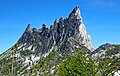
Prusik Peak seen from Gnome Tarn
Highest point
Elevation 8,000 ft (2,400 m) [1]
Prominence 160 ft (49 m) [1]
Coordinates 47°29′15″N120°47′04″W / 47.487398°N 120.784552°W / 47.487398; -120.784552 [1]
Geography
USA Washington relief location map.jpg
Red triangle with thick white border.svg
Prusik Peak
Location of Prusik Peak in Washington
Usa edcp relief location map.png
Red triangle with thick white border.svg
Prusik Peak
Prusik Peak (the United States)
Location Chelan County
Washington state, U.S.
Parent range Cascade Range
Topo map USGS Enchantment Lakes
Geology
Type of rock Granite
Climbing
First ascent May 1948 by Fred Beckey and Art Holben [2]
Easiest route Climbing class 5.6

Prusik Peak [3] is an 8000+ ft granite summit located at the west end of The Temple in Chelan County of Washington state. Prusik Peak is part of The Enchantments within the Alpine Lakes Wilderness, and is often the iconic photographic image of both areas. Prusik Peak belongs to the Stuart Range which is a subset of the Cascade Range. The name honors Dr. Karl Prusik (1896–1961) who was an Austrian mountaineer, and is known as the inventor of the prusik, a rope knot which happened to be used to gain access to the summit horn during the first ascent by Fred Beckey in 1948. Precipitation runoff drains into Icicle Creek, a tributary of the Wenatchee River.

Contents

Climate

Most weather fronts originate in the Pacific Ocean, and travel east toward the Cascade Mountains. As fronts approach, they are forced upward by the peaks of the Cascade Range, causing them to drop their moisture in the form of rain or snowfall onto the Cascades (Orographic lift). As a result, the Cascades experience high precipitation, especially during the winter months in the form of snowfall. During winter months, weather is usually cloudy, but, due to high pressure systems over the Pacific Ocean that intensify during summer months, there is often little or no cloud cover during the summer. [2] Because of maritime influence, snow tends to be wet and heavy, resulting in high avalanche danger. [2]

Geology

The Alpine Lakes Wilderness features some of the most rugged topography in the Cascade Range with craggy peaks and ridges, deep glacial valleys, and granite walls spotted with over 700 mountain lakes. [4] Geological events occurring many years ago created the diverse topography and drastic elevation changes over the Cascade Range leading to the various climate differences.

The history of the formation of the Cascade Mountains dates back millions of years ago to the late Eocene Epoch. [5] With the North American Plate overriding the Pacific Plate, episodes of volcanic igneous activity persisted. [5] In addition, small fragments of the oceanic and continental lithosphere called terranes created the North Cascades about 50 million years ago. [5]

During the Pleistocene period dating back over two million years ago, glaciation advancing and retreating repeatedly scoured the landscape leaving deposits of rock debris. [5] The last glacial retreat in the Alpine Lakes area began about 14,000 years ago and was north of the Canada–US border by 10,000 years ago. [5] The U-shaped cross section of the river valleys is a result of that recent glaciation. Uplift and faulting in combination with glaciation have been the dominant processes which have created the tall peaks and deep valleys of the Alpine Lakes Wilderness area.

Climbing Routes

Climbing Solid Gold route Solid Gold route on Prusik Peak.jpg
Climbing Solid Gold route

Established rock climbing routes on Prusik Peak: [6]

See also

Related Research Articles

<span class="mw-page-title-main">Enchantment Peak</span> Mountain in Washington (state), United States

Enchantment Peak is an 8,520+ ft granite summit located in Chelan County of Washington state. Enchantment Peak is part of The Enchantments within the Alpine Lakes Wilderness. Enchantment Peak belongs to the Stuart Range which is subset of the Cascade Range. Enchantment Peak is situated midway between Prusik Peak to its east, and Aasgard Pass and Dragontail Peak to the west. Precipitation runoff drains into Icicle Creek, a tributary of the Wenatchee River.

<span class="mw-page-title-main">Little Annapurna</span> Mountain in Washington (state), United States

Little Annapurna is an 8,440+ ft granite summit located in Chelan County of Washington state. The origin of the name came from the Sherpa Climbing Club of Ellensburg, and is inspired by the obvious resemblance to its Himalayan namesake when comparing the south faces of both. Little Annapurna is part of The Enchantments within the Alpine Lakes Wilderness, and is set on land managed by the Okanogan–Wenatchee National Forest. It belongs to the Stuart Range which is subset of the Cascade Range. Little Annapurna is situated southeast of Dragontail Peak, which is its nearest higher neighbor. Remnants of the receding Snow Creek Glacier can be found on its gentle north slope. Precipitation runoff drains into tributaries of the Wenatchee River.

<span class="mw-page-title-main">Jabberwocky Tower</span>

Jabberwocky Tower is a 6,840-foot-elevation granite spire located in Chelan County of Washington state. Jabberwocky Tower is part of The Enchantments within the Alpine Lakes Wilderness. It belongs to the Stuart Range which is subset of the Cascade Range. Jabberwocky Tower is situated east of Colchuck Lake and west of Enchantment Peak. Precipitation runoff drains into Icicle Creek, a tributary of the Wenatchee River.

<span class="mw-page-title-main">Cannon Mountain (Washington)</span> Mountain in Washington (state), United States

Cannon Mountain is an 8,638 ft mountain summit located in Chelan County of Washington state. Cannon Mountain is part of The Enchantments, within the Alpine Lakes Wilderness. Cannon Mountain belongs to the Stuart Range which is subset of the Cascade Range. Cannon Mountain is situated one mile north of Enchantment Peak. The nearest higher peak is Dragontail Peak, 2.15 mi (3.46 km) to the southwest. Precipitation runoff drains into Icicle Creek, a tributary of the Wenatchee River.

<span class="mw-page-title-main">Cashmere Mountain</span> Mountain in Washington (state), United States

Cashmere Mountain is an 8,501-foot (2,591-metre) mountain summit located in Chelan County of Washington state. Cashmere Mountain is situated within the Alpine Lakes Wilderness, on land managed by the Okanogan–Wenatchee National Forest. It is part of the Wenatchee Mountains which are subset of the Cascade Range. Its nearest higher neighbor is Cannon Mountain, 4.4 mi (7.1 km) to the southeast. Precipitation runoff from this mountain drains into tributaries of Icicle Creek, which in turn is a tributary of the Wenatchee River.

<span class="mw-page-title-main">Snowgrass Mountain</span> Mountain in Washington (state), United States

Snowgrass Mountain is a 7,993-foot (2,436-metre) mountain summit located in Chelan County of Washington state. Snowgrass Mountain is situated northeast of Frosty Pass and within the Alpine Lakes Wilderness. Snowgrass Mountain is the second-highest peak in the Chiwaukum Mountains, a subset of the Cascade Range. Its nearest higher peak is Big Chiwaukum, 1.23 mi (1.98 km) to the north. Precipitation runoff from Snowgrass drains into tributaries of the Wenatchee River.

<span class="mw-page-title-main">Big Chiwaukum</span> Mountain in Washington (state), United States

Big Chiwaukum is a prominent 8,081-foot (2,463-metre) mountain summit located in Chelan County of Washington state. Big Chiwaukum is situated northeast of Frosty Pass, and within the Alpine Lakes Wilderness. Big Chiwaukum is the highest peak in the Chiwaukum Mountains, a subset of the Cascade Range. In the Wenatchee dialect, Chiwaukum means many little creeks running into one big one. Its nearest higher peak is Cashmere Mountain, 10.35 mi (16.66 km) to the south-southeast. Precipitation runoff from Big Chiwaukum drains into tributaries of the Wenatchee River.

<span class="mw-page-title-main">Colchuck Balanced Rock</span> Mountain summit in Washington, US

Colchuck Balanced Rock is an 8,200+ ft granite mountain summit located in Chelan County of Washington state. Colchuck Balanced Rock is part of The Enchantments within the Alpine Lakes Wilderness. It belongs to the Stuart Range which is subset of the Cascade Range. Colchuck Balanced Rock is situated west of Enchantment Peak, and east of Jabberwocky Tower and Colchuck Lake. Precipitation runoff from the peak drains into the lake and Mountaineer Creek, a tributary of Icicle Creek. The climbing approach is via the Colchuck Lake Trail, then traversing away from Aasgard Pass approximately 400 feet above the lake. The mountain is named for its pyramidal summit which has a top-block that nests, rather than balances, on the summit. The mountain and glacier take their name from the lake, which in Chinook jargon means "cold water".

<span class="mw-page-title-main">The Cradle (Washington)</span> Mountain in Washington (state), United States

The Cradle is a prominent 7,467-foot (2,276-metre) double summit mountain located in Chelan County of Washington state. The mountain's name is derived from the depression between the two peaks of nearly identical elevation. The Cradle is situated within the Alpine Lakes Wilderness and is part of the Wenatchee Mountains, which is subset of the Cascade Range. Its nearest higher peak is Jack Ridge, 5.7 mi (9.2 km) to the east-southeast. Precipitation runoff from the mountain drains into tributaries of Icicle Creek, which in turn is a tributary of the Wenatchee River. The first ascent of the south peak was made in 1944 by Gene Paxton and Dwight Watson, whereas the north peak wasn't climbed until 1952 by Bill and Gene Prater.

<span class="mw-page-title-main">Cathedral Rock (Washington)</span> Mountain in Washington (state), United States

Cathedral Rock is a 6,724 ft (2,050 m) mountain located in the Cascade Range, in Kittitas County of Washington state. It is situated within the Alpine Lakes Wilderness, on land managed by Wenatchee National Forest. Its nearest higher peak is The Citadel, 1.7 mi (2.7 km) to the southwest, and the dominant mountain in the area, Mount Daniel, rises 2.2 mi (3.5 km) to the west-northwest. Precipitation runoff from the peak drains into tributaries of the Yakima River.

<span class="mw-page-title-main">Ingalls Peak</span> Mountain in Washington (state), United States

Ingalls Peak is a 7,662-foot (2,335-metre) triple-summit mountain located in the Alpine Lakes Wilderness, along the common border of Kittitas County and Chelan County, in Washington state. Ingalls Peak is the highest point in the Teanaway area of the Wenatchee Mountains. It is situated 2 mi (3.2 km) west of Mount Stuart, and immediately west of Lake Ingalls, on land managed by Wenatchee National Forest. Its subpeaks are the South Peak and the East Peak. Precipitation runoff from the peak drains north into Jack Creek, a tributary of Icicle Creek; west into Fortune Creek; or east into Ingalls Creek, a tributary of the Wenatchee River. This peak, the lake, creek, and pass are named for Captain Benjamin Ingalls of the United States Cavalry who led an 1855 survey of this area and is credited with discovering gold in the region.

<span class="mw-page-title-main">Eightmile Mountain</span> Mountain in Washington (state), United States

Eightmile Mountain is a 7,996-foot (2,437-metre) mountain summit located in Chelan County of Washington state. Eightmile Mountain is situated within the Alpine Lakes Wilderness, on land managed by the Okanogan–Wenatchee National Forest. It is part of the Wenatchee Mountains which are a subset of the Cascade Range. Its nearest higher neighbor is Cashmere Mountain, 3 mi (4.8 km) to the northeast, and Mount Stuart rises 4 mi (6.4 km) to the south. Precipitation runoff from the mountain drains into Trout Creek and Eightmile Creek, both tributaries of Icicle Creek, which in turn is a tributary of the Wenatchee River. This mountain is known for its spring skiing and excellent view of the Stuart Range.

<span class="mw-page-title-main">Granite Mountain (Wenatchee Mountains)</span> Mountain in Washington (state), United States

Granite Mountain is a 7,144-foot (2,177-metre) double summit mountain located 11.5 mi (18.5 km) south of Stevens Pass on the common border of Kittitas County and Chelan County in Washington state. It's part of the Wenatchee Mountains, which are a subset of the Cascade Range, and is situated 19 mi (31 km) west of Leavenworth in the Alpine Lakes Wilderness, on land managed by the Okanogan–Wenatchee National Forest. Granite Mountain is the highest point on the Hyas Lake-French Creek divide with precipitation runoff from the mountain draining west into Cle Elum River, or east into French Creek, a tributary of Icicle Creek. Its subsidiary 7,080-ft South Peak is positioned half a mile to the south-southeast, the nearest higher neighbor is The Cradle, 3 mi (4.8 km) to the southeast, and Mac Peak is set 3.6 mi (5.8 km) to the north-northwest. The Pacific Crest Trail skirts below the western base this peak.

<span class="mw-page-title-main">Trico Mountain</span> Mountain in Washington, United States of America

Trico Mountain is a 6,640+ ft mountain summit located 10 mi (16 km) south of Stevens Pass on the common border of King County, Kittitas County and Chelan County in Washington state. "Trico" is a portmanteau of triple county. This peak is part of the Wenatchee Mountains, which are a subset of the Cascade Range, and is situated 20 mi (32 km) west of Leavenworth in the Alpine Lakes Wilderness. Trico is a triple divide peak with precipitation runoff from the mountain draining south into Cle Elum River, northwest into Deception Creek, and northeast into Leland Creek, which is a tributary of Icicle Creek. The scenic Tuck and Robin Lakes are set on the south slopes, between Trico and Granite Mountain, which is 1.6 mi (2.6 km) to the southeast. The Pacific Crest Trail skirts below the western aspect this peak as it crosses Deception Pass.

<span class="mw-page-title-main">Cape Horn (Washington)</span> Mountain in Washington (state), United States

Cape Horn is a 7,316-foot (2,230-metre) mountain summit located in Chelan County of Washington state. Cape Horn is situated 12 mi (19 km) west-northwest of Leavenworth, within the Alpine Lakes Wilderness, on land managed by the Okanogan–Wenatchee National Forest. Cape Horn is part of the Chiwaukum Mountains, a subset of the Cascade Range. Its nearest higher neighbor is Ladies Peak, 0.9 mi (1.4 km) to the northwest, and Grindstone Mountain is set 1.4 mi (2.3 km) to the south. Precipitation runoff from Cape Horn drains west to Icicle Creek, whereas the east slopes drain into Chiwaukum Creek, and both are tributaries of the Wenatchee River. Although modest in elevation, relief is significant since this peak rises over 4,300 feet above Icicle Creek Valley in approximately two miles. This mountain was named by Albert Hale Sylvester in 1909 for its sharp profile.

<span class="mw-page-title-main">Ladies Peak</span> Mountain in Washington (state), United States

Ladies Peak is a 7,708-foot (2,349-metre) mountain summit located in Chelan County of Washington state. Ladies Peak is situated 13 mi (21 km) west-northwest of Leavenworth, within the Alpine Lakes Wilderness, on land managed by the Okanogan–Wenatchee National Forest. Ladies Peak is part of the Chiwaukum Mountains, a subset of the Cascade Range. Its nearest higher neighbor is Snowgrass Mountain, 1.27 mi (2.04 km) to the north, and Cape Horn is set 0.9 mi (1.4 km) to the southeast. Precipitation runoff from Ladies Peak drains west to Icicle Creek, whereas the east slopes drain into Chiwaukum Creek, and both are tributaries of the Wenatchee River. Although modest in elevation, relief is significant since this peak rises over 4,700 feet above Icicle Creek Valley in approximately two miles. This unofficially named peak is named in association with the nearby officially named Ladies Pass, which like many geographical features in this region was named by Albert Hale Sylvester.

<span class="mw-page-title-main">Witches Tower (Washington)</span> Mountain in Washington (state), United States

Witches Tower is an 8,520+ ft granite summit located 10 mi (16 km) southwest of Leavenworth in Chelan County of Washington state. Witches Tower is part of The Enchantments within the Alpine Lakes Wilderness, and is set on land managed by the Okanogan–Wenatchee National Forest. It belongs to the Stuart Range which is subset of the Wenatchee Mountains. Witches Tower is situated 0.8 mi (1.3 km) northwest of Little Annapurna, and 0.4 mi (0.64 km) east-southeast of Dragontail Peak, which is its nearest higher neighbor. Witches Tower is surrounded by remnants of Snow Creek Glacier. Precipitation runoff drains into tributaries of the Wenatchee River.

<span class="mw-page-title-main">Big Jim Mountain</span> Mountain in Washington (state), United States

Big Jim Mountain is a 7,763-foot (2,366-metre) mountain summit located in Chelan County of Washington state. It is situated 9 mi (14 km) northwest of Leavenworth, within the Alpine Lakes Wilderness, on land managed by the Okanogan–Wenatchee National Forest. Big Jim Mountain is the fourth-highest peak in the Chiwaukum Mountains, a subset of the Cascade Range. Its nearest higher neighbor is Big Lou, 1.75 mi (2.82 km) to the south-southwest, and Cape Horn is set 4 mi (6.4 km) to the west. Precipitation runoff from Big Jim drains into tributaries of the Wenatchee River. Although modest in elevation, relief is significant since Big Jim rises 2,300 feet above Painter Creek Valley in one mile. Big Jim Mountain is named for Jim Whittaker, the first American to summit Mount Everest and twin brother of Lou Whittaker.

<span class="mw-page-title-main">Big Lou</span> Mountain in Washington (state), United States

Big Lou is a 7,780+ ft mountain summit located in Chelan County of Washington state. It is situated 8.5 mi (13.7 km) west-northwest of Leavenworth, on the boundary of the Alpine Lakes Wilderness, and on land managed by the Okanogan–Wenatchee National Forest. Big Lou is the highest point on Icicle Ridge, and is the third-highest peak in the Chiwaukum Mountains, a subset of the Cascade Range. Its nearest higher neighbor is Snowgrass Mountain, 5 mi (8.0 km) to the northwest, and slightly lower Big Jim Mountain is set 1.75 mi (2.82 km) to the north-northeast. Precipitation runoff from Big Lou drains into Icicle Creek and other tributaries of the Wenatchee River. Although modest in elevation, relief is significant since Big Lou rises 5,200 feet above Icicle Creek Valley in approximately two miles. Big Lou is named for mountaineer Lou Whittaker, the twin brother of Jim Whittaker, the first American to summit Mount Everest.

<span class="mw-page-title-main">Edward Peak</span> Mountain in Washington (state), United States

Edward Peak, also known as The Mole, is a 7,280-foot (2,219-metre) granite summit located in Chelan County of Washington state. It is set within the Alpine Lakes Wilderness, on land managed by Okanogan-Wenatchee National Forest. Edward Peak belongs to the Stuart Range which is a subset of the Cascade Range. It is situated 1.9 miles (3.1 km) north of The Temple, and the nearest town is Leavenworth, 7 miles (11 km) to the northeast. Precipitation runoff from the mountain drains north into Icicle Creek via Rat Creek.

References

summit detail Prusik Peak from Gnome Tarn.jpg
summit detail
  1. 1 2 3 "Prusik Peak, Washington". Peakbagger.com.
  2. 1 2 3 Beckey, Fred W. Cascade Alpine Guide, Climbing and High Routes. Seattle, WA: Mountaineers Books, 2008.
  3. "Prusik Peak". Geographic Names Information System . United States Geological Survey, United States Department of the Interior . Retrieved 2018-08-01.
  4. Smoot, Jeff (2004). Backpacking Washington's Alpine Lakes Wilderness. Helena, Montana: The Globe Pequot Press.
  5. 1 2 3 4 5 Kruckeberg, Arthur (1991). The Natural History of Puget Sound Country. University of Washington Press.
  6. Prusik Peak Rock Climbing Mountain Project
Prusik Peak (left) seen from Leprechaun Lake along with other towers of The Temple Prusik Peak Leprechaun Lake The Temple.jpg
Prusik Peak (left) seen from Leprechaun Lake along with other towers of The Temple