
Skykomish is a town in King County, Washington, United States. The population was 161 as of the 2020 census, down from an estimated peak of "several thousand" in the 1920s.

The North Cascades are a section of the Cascade Range of western North America. They span the border between the Canadian province of British Columbia and the U.S. state of Washington and are officially named in the U.S. and Canada as the Cascade Mountains. The portion in Canada is known to Americans as the Canadian Cascades, a designation that also includes the mountains above the east bank of the Fraser Canyon as far north as the town of Lytton, at the confluence of the Thompson and Fraser Rivers.
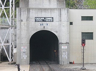
The Cascade Tunnel refers to two railroad tunnels, its original tunnel and its replacement, in the northwest United States, east of the Seattle metropolitan area in the Cascade Range of Washington, at Stevens Pass. It is approximately 65 miles (105 km) east of Everett, with both portals adjacent to U.S. Route 2. Both single-track tunnels were constructed by the Great Northern Railway.

The Skykomish River is a 29-mile (47 km) long river in the U.S. state of Washington which drains the west side of the Cascade Mountains in the southeast section of Snohomish County and the northeast corner of King County. The river starts with the confluence of the North Fork Skykomish River and South Fork Skykomish River approximately one mile west of Index, then flowing northwesterly towards Puget Sound. It is joined by the Sultan River and the Wallace River at Sultan. It then meets the Snoqualmie River to form the Snohomish River at Monroe. The Snohomish River continues along the river valley eventually dumping into Port Gardner Bay on Possession Sound.
Wellington was a small unincorporated railroad community in the northwest United States, on the Great Northern Railway in northeastern King County, Washington.

Alpental, named after the German word for alpine valley, is both a valley in eastern King County, Washington, United States, and part of a ski area in the valley. The valley is about 50 miles (80 km) east of Seattle, Washington and is north of Snoqualmie Pass, in the Washington Cascades. It is a popular outdoor recreation destination in summer and winter. The ski area is one of four areas that make up The Summit at Snoqualmie.
The Henry M. Jackson Wilderness is a 103,297-acre (41,803 ha) designated wilderness area in the state of Washington, United States. The area lies adjacent to the southwest corner of the Glacier Peak Wilderness, northwest of Stevens Pass on U.S. Highway 2 and northeast of the town of Skykomish, Washington. Wild Sky Wilderness is located immediately southwest of the Henry M. Jackson Wilderness. While the wilderness straddles the Cascade Mountain Range, most of it is in the westside ecotype. The wilderness lies in parts of Snoqualmie, Mount Baker, and Wenatchee national forests.

The Alpine Lakes Wilderness is a large wilderness area spanning the Central Cascades of Washington state in the United States. The wilderness is located in parts of Wenatchee National Forest and Snoqualmie National Forest, and is approximately bounded by Interstate 90 and Snoqualmie Pass to the south and U.S. Route 2 and Stevens Pass to the north. The Alpine Lakes is the largest wilderness area near the population centers of Puget Sound, counted at 414,161 acres (167,605 ha) following the 2014 expansion.
Stampede Pass is a mountain pass in the northwest United States, through the Cascade Range in Washington. Southeast of Seattle and east of Tacoma, its importance to transportation lies almost entirely with railroading, as no paved roads cross it. It is approximately twelve miles (20 km) south-southeast of Snoqualmie Pass, the gap for Interstate 90, and two miles (3 km) south of Keechelus Lake.

The Stevens Pass Ski Area is a ski area in the Cascade Range of Washington in the United States. It is located at the crest of Stevens Pass at a base elevation of 4,061 feet (1,238 m) above sea level and peak elevation at 5,845 feet (1,782 m). The Mill Valley "backside" of the resort drops to a minimum elevation of 3,821 feet (1,165 m). Total skiable terrain includes 37 major runs covering 1,125 acres (4.55 km2). The ski area is accessed via U.S. Route 2, which connects to nearby Leavenworth.

Keechelus Lake is a lake and reservoir in the northwest United States, near Hyak in Kittitas County, Washington. Approximately fifty miles (80 km) southeast of Seattle and a few miles southeast of Snoqualmie Pass, it is the source of the Yakima River.

Snoqualmie Pass is a mountain pass that carries Interstate 90 (I-90) through the Cascade Range in the U.S. state of Washington. The pass summit is at an elevation of 3,015 feet (919 m), on the county line between Kittitas County and King County.

The geography of the North Cascades describes a range of rugged mountains in British Columbia, Canada and Washington, United States. In Canada, the range is officially named the Cascade Mountains but is commonly referred to as the Canadian Cascades.
The Tye River is a river in the U.S. state of Washington. It rises near Stevens Pass in the Cascade Mountains and flows west, joining the Foss River to form the South Fork Skykomish River. Its waters eventually empty into Puget Sound near Everett via the Skykomish River and Snohomish River. U.S. Route 2 follows the river's entire length. A BNSF Railway line follows most of the river except near the pass where the tracks use the Cascade Tunnel. Powerlines run by the Bonneville Power Administration (BPA) follow the Tye River west of Tunnel Creek.

The Beckler River is a tributary of the South Fork Skykomish River in the U.S. state of Washington in the United States.
The 2012 Tunnel Creek avalanche occurred in the northwest United States on February 19, 2012. It happened at about noon PST in the Tunnel Creek section of Stevens Pass, a mountain pass through the Cascade Mountains of Washington, at the border of King and Chelan counties. There were three fatalities and one injured.

The Stevens Pass Historic District is an area within a large rectangle 3.2 by 18.2 miles and extends from the Martin Creek Tunnel on the western slope of the crest to the eastern portal of the present Cascade Tunnel above Nason Creek on the eastern slope. The area is ruggedly mountainous and the terrain is covered with timber and granitic outcroppings. The Cascade Range interfered with the Great Northern Railway effort to develop a deep water western terminus in Puget Sound. A gap in the Cascade Range, at Stevens Pass, was found suitable at an elevation slightly in excess of 4,000 feet (1,200 m) about 45 miles (72 km) east of Seattle. The first effort an elaborate switchback system, replaced by a tunnel which was itself replaced by a second tunnel.

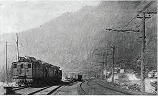
Jim Hill Mountain is a prominent 6,765 ft (2,060 m) mountain summit located in Chelan County of Washington state. Jim Hill Mountain is situated 3.5 mi (5.6 km) east of Stevens Pass, on the boundary of Alpine Lakes Wilderness, on land managed by the Okanogan–Wenatchee National Forest. Jim Hill Mountain is part of the Chiwaukum Mountains, which are a subset of the Cascade Range. Its nearest higher neighbor is Bulls Tooth, 3.8 mi (6.1 km) to the south. Precipitation runoff from the peak drains into tributaries of Nason Creek, which in turn is a tributary of the Wenatchee River. Jim Hill Mountain is set immediately south of the east portal of the Cascade Tunnel, which was built by the Great Northern Railway. This mountain was named by Albert Hale Sylvester to honor James J. Hill (1838–1916), the chief executive officer of the Great Northern Railway. Hill became known during his lifetime as "The Empire Builder", a name bestowed to the Empire Builder passenger train that runs from Seattle to Chicago, and traverses below this mountain.

Cowboy Mountain is a 5,853-foot-elevation mountain summit located in northeast King County of Washington state. It is situated at Stevens Pass, on land managed by Mount Baker-Snoqualmie National Forest. This mountain is best known for ski runs on its north slopes which are part of the Stevens Pass Ski Area. Cowboy Mountain is part of the Chiwaukum Mountains, which are a subset of the Cascade Range. Its nearest higher neighbor is Big Chief Mountain, 1.9 mi (3.1 km) to the northeast, and the Pacific Crest Trail passes through the saddle between these two mountains. Precipitation runoff from the peak drains into headwaters of the Tye River, which in turn is a tributary of the Skykomish River. The longest railroad tunnel in the United States, the Cascade Tunnel, was bored directly under Cowboy Mountain, as a response to deadly avalanches that threatened trains of the Great Northern Railway. The deadliest avalanche in the history of the United States, the 1910 Wellington avalanche, occurred approximately two miles west of Cowboy Mountain.

Skykomish Peak is a 6,368-foot (1,941-metre) mountain summit located in the Henry M. Jackson Wilderness in the North Cascades of Washington state. The mountain is situated on the crest of the Cascade Range, on the shared border of Snohomish County with Chelan County, and also straddling the boundary between Mount Baker-Snoqualmie National Forest and Okanogan-Wenatchee National Forest. Skykomish Peak is located 15 mi (24 km) to the north of Stevens Pass, and the Pacific Crest Trail traverses the east slope of this peak. Precipitation runoff from the peak drains west into the Skykomish River, or east into Cady Creek which is a tributary of Little Wenatchee River. This mountain's name derives from its position at the head of the North Fork Skykomish River, and "Skykomish" comes from the Lushootseed word for the Skykomish people, sq̓ixʷəbš, meaning "upriver people".

