
The Snoqualmie River is a 45-mile (72 km) long river in King County and Snohomish County in the U.S. state of Washington. The river's three main tributaries are the North, Middle, and South Forks, which drain the west side of the Cascade Mountains near the town of North Bend and join near the town of Snoqualmie just above the Snoqualmie Falls. After the falls the river flows north through rich farmland and the towns of Fall City, Carnation, and Duvall before meeting the Skykomish River to form the Snohomish River near Monroe. The Snohomish River empties into Puget Sound at Everett. Other tributaries of the Snoqualmie River include the Taylor River and the Pratt River, both of which enter the Middle Fork, the Tolt River, which joins at Carnation, and the Raging River at Fall City.

The Newaukum River is a tributary of the Chehalis River in the U.S. state of Washington. It has three main branches, the North Fork, South Fork, and Middle Fork Newaukum Rivers. The length of the three forks and the mainstem river is 56.7 miles (91.2 km).

The Feather River is the principal tributary of the Sacramento River, in the Sacramento Valley of Northern California. The river's main stem is about 73 miles (117 km) long. Its length to its most distant headwater tributary is just over 210 miles (340 km). The main stem Feather River begins in Lake Oroville, where its four long tributary forks join—the South Fork, Middle Fork, North Fork, and West Branch Feather Rivers. These and other tributaries drain part of the northern Sierra Nevada, and the extreme southern Cascades, as well as a small portion of the Sacramento Valley. The total drainage basin is about 6,200 square miles (16,000 km2), with approximately 3,604 square miles (9,330 km2) above Lake Oroville.

The Sauk River is a tributary of the Skagit River, approximately 45 miles (72 km) long, in northwestern Washington in the United States. It drains an area of the high Cascade Range in the watershed of Puget Sound north of Seattle. The river is a popular destination for fly fishing. It is a National Wild and Scenic River.

The Skykomish River is a 29-mile (47 km) long river in the U.S. state of Washington which drains the west side of the Cascade Mountains in the southeast section of Snohomish County and the northeast corner of King County. The river starts with the confluence of the North Fork Skykomish River and South Fork Skykomish River approximately one mile west of Index, then flowing northwesterly towards Puget Sound. It is joined by the Sultan River and the Wallace River at Sultan. It then meets the Snoqualmie River to form the Snohomish River at Monroe. The Snohomish River continues along the river valley eventually dumping into Port Gardner Bay on Possession Sound.

The Alpine Lakes Wilderness is a large wilderness area spanning the Central Cascades of Washington state in the United States. The wilderness is located in parts of Wenatchee National Forest and Snoqualmie National Forest, and is approximately bounded by Interstate 90 and Snoqualmie Pass to the south and U.S. Route 2 and Stevens Pass to the north. The Alpine Lakes is the largest wilderness area near the population centers of Puget Sound, counted at 414,161 acres (167,605 ha) following the 2014 expansion.

The Tule River, also called Rio de San Pedro or Rio San Pedro, is a 71.4-mile (114.9 km) river in Tulare County in the U.S. state of California. The river originates in the Sierra Nevada east of Porterville and consists of three forks, North, Middle and South. The North Fork and Middle Fork meet above Springville. The South Fork meets the others at Lake Success. Downstream of Success Dam, the river flows west through Porterville. The river used to empty into Tulare Lake, but its waters have been diverted for irrigation. The river reaches Tulare Lake during floods. Tulare Lake is the terminal sink of an endorheic basin that historically also received the Kaweah and Kern Rivers as well as southern distributaries of the Kings.

The Naches River is a tributary of the Yakima River in central Washington in the United States. Beginning as the Little Naches River, it is about 75 miles (121 km) long. After the confluence of the Little Naches and Bumping River the name becomes simply the Naches River. The Naches and its tributaries drain a portion of the eastern side of the Cascade Range, east of Mount Rainier and northeast of Mount Adams. In terms of discharge, the Naches River is the largest tributary of the Yakima River.

The Sol Duc River is a river in the U.S. state of Washington. About 78 miles (126 km) long, it flows west through the northwest part of the Olympic Peninsula, from the Olympic Mountains of Olympic National Park and Olympic National Forest, then through the broad Sol Duc Valley. Near the Pacific Ocean the Sol Duc River joins the Bogachiel River, forming the Quillayute River, which flows about 4 miles (6.4 km) to the Pacific Ocean at La Push. Although the Quillayute River is short, its large tributary rivers—the Sol Duc, Bogachiel, Calawah, and Dickey Rivers—drain the largest watershed of the northern Olympic Peninsula, 629 square miles (1,630 km2). The Sol Duc's watershed is the largest of the Quillayute's tributaries, at 219 square miles (570 km2).

The Sultan River is a river in Snohomish County in the U.S. state of Washington. It is a tributary of the Skykomish River, which it joins at the town of Sultan, Washington. The river is dammed in its upper third by Culmback Dam to form Spada Lake.
The Taylor River is a river in King County in Washington.
The Miller River is a river in King County, Washington. Named for 1890s prospector John Miller, it is a tributary of the Skykomish River, which it joins near the community of Miller River. The Miller River is about 3.5 miles (5.6 km) long from the confluence of its main tributaries, the East Fork and West Fork. Miller River Campground is located just downriver from the confluence.

The Dickey River is a stream on the Olympic Peninsula in the U.S. state of Washington. It has three main forks, the East Fork, West Fork, and Middle Fork Dickey Rivers. The main stem is formed by the confluence of the East and West Forks. The river and its forks rise in the northwestern part of the Olympic Peninsula and flow generally south and west to join the Quillayute River near its mouth on the Pacific Ocean.
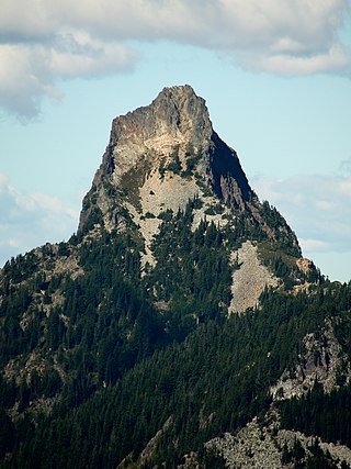
Kaleetan Peak is a prominent 6,259-foot (1,908-metre) mountain summit located in King County of Washington state. It's part of the Cascade Range and is situated four miles northwest of Snoqualmie Pass. Kaleetan Peak is set within the Alpine Lakes Wilderness on land managed by Mount Baker-Snoqualmie National Forest. It's immediately west of Melakwa Pass and Chair Peak, and north of Melakwa Lake. Precipitation runoff from the mountain drains into tributaries of the Snoqualmie River. Topographic relief is significant as the summit rises approximately 2,400 feet (730 m) above Kaleetan Lake in 0.6 mi (0.97 km). The nearest higher peak is Snoqualmie Mountain, 2.89 miles (4.65 km) to the east. The mountain's name "Kaleetan" derives from Chinook Jargon which means "arrow". The peak was named by members of The Mountaineers and the toponym was officially adopted in 1916 by the U.S. Board on Geographic Names.
Avalanche Lake is a small alpine freshwater lake located on the northern skirt of Chikamin Peak and Lemah Mountain in King County, Washington. Because of its proximity to surrounding peaks and mountains at the heart of the Alpine Lakes Wilderness, the lake is a popular area for hiking. Other Alpine lakes are in the vicinity, including the Iceberg Lake a short distance East, at the base of Chimney Rock West. To the South is Chikamin Lake.
Myrtle Lake is a freshwater lake located on the northern slope of Big Snow Mountain between Snoqualmie Lake and Chetwoot Lake, in King County, Washington. Self-issued Alpine Lake Wilderness permit required for transit within the Big Snow Mountain area. Because Myrtle Lake is at the heart of the Alpine Lakes Wilderness, the lake is a popular area for hiking, swimming, and fishing rainbow trout and coastal cutthroat trout.
Lake Kanim is a set of small freshwater lakes located on a clif of the south skirt of Lennox Mountain, in King County, Washington. Lake Kanim is the nascent source of the North Fork of the Snoqualmie River. The lake and its accompanying waterfall were named after Jerry Kanim who was the leader of Snoqualmie people.
Island Lakes are a set of closely related freshwater lakes located on a prominent valley at the western base of Pratt Mountain, between Mount Defiance and Bandera Mountain, in King County, Washington. They include Island Lake proper, Rainbow Lake and Blazer Lake. They are themselves surrounded by other alpine lakes, including Lake Kulla Kulla and Mason Lake on the west side of the valley. Because of its proximity to Snoqualmie Pass and other prominent peaks in the Alpine Lakes Wilderness, the lakes are a popular area for hiking, swimming, and fishing rainbow trout. Access to Island Lakes is through Mount Defiance Trail 1009, which is an offshoot of Pratt Lake Trail 1007. The trail passes between Rainbow Lake and Blazer Lake on the north edge.

