
Puget Sound is a complex estuarine system of interconnected marine waterways and basins located on the northwest coast of the U.S. state of Washington. As a part of the Salish Sea, the sound has one major and two minor connections to the Strait of Juan de Fuca, which in turn connects to the open Pacific Ocean. The major connection is Admiralty Inlet; the minor connections are Deception Pass and the Swinomish Channel.

King County is a county located in the U.S. state of Washington. The population was 2,269,675 in the 2020 census, making it the most populous county in Washington, and the 12th-most populous in the United States. The county seat is Seattle, also the state's most populous city.

Shoreline is a city in King County, Washington, United States. It is located between the city limits of Seattle and the Snohomish County border, approximately 9 miles (14 km) north of Downtown Seattle. As of the 2020 census, the population of Shoreline was 58,608, making it the 22nd largest city in the state. Based on per capita income, one of the more reliable measures of affluence, Shoreline ranks 91st of 522 areas in the state of Washington to be ranked.

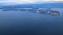
Vashon is a census-designated place (CDP) in King County, Washington, United States. It covers an island alternately called Vashon Island or Vashon–Maury Island, the largest island in Puget Sound south of Admiralty Inlet. The population was 11,055 at 2020, up from 10,624 at the 2010 census and the size is 36.9 square miles (95.6 km2).

Wedgwood Rock is a glacial erratic near the neighborhood of Wedgwood in Seattle, Washington. Its mineral composition matches that of Mount Erie, on Fidalgo Island in Skagit County, Washington, 55 mi (89 km) north. Prior to the establishment of the Wedgwood neighborhood, the erratic was known first as Lone Rock and later simply as Big Rock. Transported to its site by the Puget Lobe of the Cordilleran Ice Sheet during the Vashon Glaciation more than 14,000 years ago, it was a landmark for Native Americans in what was once a dense forest.
Blake Island is a Puget Sound island in Kitsap County, Washington, United States, that is preserved as Blake Island Marine State Park. The island lies north of Vashon Island, south of Bainbridge Island, and east of Manchester. On the northeast end of the island is Tillicum Village, a tourist attraction based on Northwest Coast Indian arts, culture, and food. The park is managed by the Washington State Parks and Recreation Commission.

Puget Sound is a deep inlet of the Pacific Ocean in Washington, extending south from the Strait of Juan de Fuca through Admiralty Inlet. It was explored and named by Captain George Vancouver for his aide, Peter Puget, in 1792.
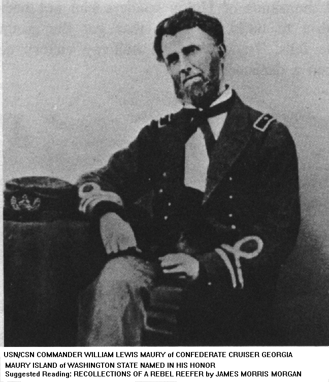
Preserve Our Islands is a grassroots organization, created by Senator Sharon Nelson and residents of Maury Island, Washington, United States, that is opposed to Glacier Northwest and their efforts to mine aggregate on Maury Island.
Dockton is an unincorporated community in King County, Washington. It is located on Maury Island, along Quartermaster Harbor. Although once an industrial center, Dockton today is a primarily residential area, with many commuters taking the ferry to nearby Tacoma.

The King County Water Taxi is a passenger-only fast ferry service operated by the King County Metro Transit Department, Marine Division. It operates two routes between Downtown Seattle and West Seattle or Vashon Island.
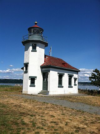
The Point Robinson Light is an operational aid to navigation and historic lighthouse on Puget Sound, located at Point Robinson, the easternmost point of Maury Island, King County, in the U.S. state of Washington. The site was listed on the National Register of Historic Places in 2004.
Seahurst Park, in Burien, Washington, is a 178-acre (0.72 km2) park with forests and a beach on Puget Sound. Originally a King County park, it was given to the newly incorporated city of Burien in 1996. The beach is about 2,000 feet (610 m) long, and the upper part of the beach has been made into a sea wall.
The environmental issues on Maury Island are linked to broader Puget Sound environmental issues, which include concerns regarding declining salmon and forage fish populations, degrading critical marine and shoreline habitats, and threatened species such as the Orca.

State Route 339 (SR 339) is a 8.5-nautical-mile-long state highway in the U.S. state of Washington. It is designated on a former state-run ferry route that connected Vashon Island's Vashon Heights ferry terminal to downtown Seattle's Pier 50, via a passenger-only ferry, the MV Skagit. The ferry was financed by the King County Ferry District (KCFD) and tolls collected at Pier 50. Despite being part of the KCFD, the ferry was operated by Washington State Ferries (WSF). SR 339 was one of only four ferry routes providing access to and from Vashon Island, and had the lowest annual average ridership of the four routes. The state of Washington took over the operation of the ferry route in 1951, and designated it SR 339 in 1994. The ferry was discontinued in 2006 and was replaced by a King County Water Taxi route.

The Puget Sound region is a coastal area of the Pacific Northwest in the U.S. state of Washington, including Puget Sound, the Puget Sound lowlands, and the surrounding region roughly west of the Cascade Range and east of the Olympic Mountains. It is characterized by a complex array of saltwater bays, islands, and peninsulas carved out by prehistoric glaciers.
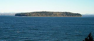
Point Robinson is the easternmost point on Maury Island, Washington, United States. It was originally a spit on Puget Sound that was named in 1841 for John Robinson, a crewmember on the United States Exploring Expedition led by U.S. naval officer Charles Wilkes.

Rocky Prairie is a Puget prairie that is about 56 miles (90 km) southwest of Seattle, Washington, and about 10 miles (16 km) south of Washington's capital city of Olympia. It sits very close to the Millersylvania State Park, the community of Maytown, and the city of Tenino.

Schumacher Creek, formerly Shumocher Creek, is a creek in Mason County in the U.S. state of Washington. It flows into Mason Lake on the traditional territory of the Squaxin Island Tribe. Schumacher Creek is part of the Sherwood Creek watershed, and contains Trask Lake and Carson Lake.

