
An aquifer is an underground layer of water-bearing, permeable rock, rock fractures, or unconsolidated materials. Groundwater from aquifers can be extracted using a water well. Water from aquifers can be sustainably harvested through the use of qanats. Aquifers vary greatly in their characteristics. The study of water flow in aquifers and the characterization of aquifers is called hydrogeology. Related terms include aquitard, which is a bed of low permeability along an aquifer, and aquiclude, which is a solid, impermeable area underlying or overlying an aquifer, the pressure of which could create a confined aquifer. The classification of aquifers is as follows: Saturated versus unsaturated; aquifers versus aquitards; confined versus unconfined; isotropic versus anisotropic; porous, karst, or fractured; transboundary aquifer.
Environmental geology, like hydrogeology, is an applied science concerned with the practical application of the principles of geology in the solving of environmental problems created by man. It is a multidisciplinary field that is closely related to engineering geology and, to a lesser extent, to environmental geography. Each of these fields involves the study of the interaction of humans with the geologic environment, including the biosphere, the lithosphere, the hydrosphere, and to some extent the atmosphere. In other words, environmental geology is the application of geological information to solve conflicts, minimizing possible adverse environmental degradation, or maximizing possible advantageous conditions resulting from the use of natural and modified environment. With an increasing world population and industrialization, the natural environment and resources are under high strain which puts them at the forefront of world issues. Environmental geology is on the rise with these issues as solutions are found by utilizing it.

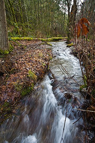
Groundwater is the water present beneath Earth's surface in rock and soil pore spaces and in the fractures of rock formations. About 30 percent of all readily available freshwater in the world is groundwater. A unit of rock or an unconsolidated deposit is called an aquifer when it can yield a usable quantity of water. The depth at which soil pore spaces or fractures and voids in rock become completely saturated with water is called the water table. Groundwater is recharged from the surface; it may discharge from the surface naturally at springs and seeps, and can form oases or wetlands. Groundwater is also often withdrawn for agricultural, municipal, and industrial use by constructing and operating extraction wells. The study of the distribution and movement of groundwater is hydrogeology, also called groundwater hydrology.

Maury Island is a tied island in Puget Sound in the U.S. state of Washington. It is connected to Vashon Island by an isthmus built by local homeowners in 1913. Before construction of the isthmus, the island was connected to Vashon only during low tide. The island is rural with large areas of farmland, forest, and relatively undeveloped shoreline. Currently, environmental issues on the island are under considerable scrutiny.
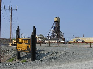
The Giant Mine was a gold mine located on the Ingraham Trail, 5 km (3.1 mi) north of Yellowknife, Northwest Territories. Giant Mine was within the Kam Group, a part of the Yellowknife greenstone belt. Gold was discovered on the property and mineral claims staked in 1935 by Johnny Baker, but the true extent of the gold deposits was not known until 1944, when a massive gold-bearing shear zone was uncovered beneath the drift-filled Baker Creek Valley.
The Waterloo Moraine is a landform and sediment body that was created as a moraine in the Regional Municipality of Waterloo, in Ontario, Canada. It covers a large portion of the cities of Waterloo and Kitchener and the township of Wilmot, and some parts of the townships of Wellesley and North Dumfries. About 90% of the water supply of the Regional Municipality of Waterloo is derived from groundwater of the Waterloo Moraine aquifer system.

The health and environmental impact of the coal industry includes issues such as land use, waste management, water and air pollution, caused by the coal mining, processing and the use of its products. In addition to atmospheric pollution, coal burning produces hundreds of millions of tons of solid waste products annually, including fly ash, bottom ash, and flue-gas desulfurization sludge, that contain mercury, uranium, thorium, arsenic, and other heavy metals. Coal is the largest contributor to the human-made increase of carbon dioxide in Earth's atmosphere.
The environmental issues on Maury Island are linked to broader Puget Sound environmental issues, which include concerns regarding declining salmon and forage fish populations, degrading critical marine and shoreline habitats, and threatened species such as the Orca.
Sharon Kay Nelson is an American politician from the state of Washington.

Long Island is in southeastern New York, United States, separated from the rest of the state by the East River and from Connecticut by Long Island Sound. Long Island contains four counties, of which the western two are boroughs of New York City, and the other two are mainly suburban.
Freshwater environmental quality parameters are those chemical, physical or biological parameters that can be used to characterise a freshwater body. Because almost all water bodies are dynamic in their composition, the relevant quality parameters are typically expressed as a range of expected concentrations.

Environmental effects of mining can occur at local, regional, and global scales through direct and indirect mining practices. Mining can cause in erosion, sinkholes, loss of biodiversity, or the contamination of soil, groundwater, and surface water by chemicals emitted from mining processes. These processes also affect the atmosphere through carbon emissions which contributes to climate change. Some mining methods may have such significant environmental and public health effects that mining companies in some countries are required to follow strict environmental and rehabilitation codes to ensure that the mined area returns to its original state.
Sequalitchew Creek, located in DuPont, Washington emanates from Sequalitchew Lake, Fort Lewis, Washington, was the location of the original Fort Nisqually trading post established in 1833 by the Hudson's Bay Company. The historic, natural flow of Sequalitchew Creek runs from Sequalitchew Lake, through Edmonds Marsh, down the canyon and out to the Puget Sound.

The Silver Bow Basin, often written as Silverbow Basin, is a valley located 2.4 miles (3.9 km) northeast of Juneau, Alaska, USA. It is situated on Gold Creek in an area north of Icy Gulch, and approximately 1.5 miles (2.4 km) north of Gastineau Peak. A trail from Juneau leads directly to the mountainside. The basin was the site of the earliest gold discovery in the Juneau area, leading to the establishment of the town called Juneau.
Rosemont Copper is a proposed large open pit copper mine project by the Canadian mining corporation Hudbay Minerals. The project site is located within the Santa Rita Mountains and Coronado National Forest, in Pima County of southern Arizona. It has undergone a permitting review process under the direction of the United States Forest Service and the U.S. Army Corps of Engineers and has been delayed by legal judgements and suspension of its operating permit by the US Army Corps of Engineers.
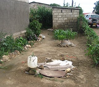
Groundwater pollution occurs when pollutants are released to the ground and make their way into groundwater. This type of water pollution can also occur naturally due to the presence of a minor and unwanted constituent, contaminant, or impurity in the groundwater, in which case it is more likely referred to as contamination rather than pollution. Groundwater pollution can occur from on-site sanitation systems, landfill leachate, effluent from wastewater treatment plants, leaking sewers, petrol filling stations, hydraulic fracturing (fracking) or from over application of fertilizers in agriculture. Pollution can also occur from naturally occurring contaminants, such as arsenic or fluoride. Using polluted groundwater causes hazards to public health through poisoning or the spread of disease.
Water in Arkansas is an important issue encompassing the conservation, protection, management, distribution and use of the water resource in the state. Arkansas contains a mixture of groundwater and surface water, with a variety of state and federal agencies responsible for the regulation of the water resource. In accordance with agency rules, state, and federal law, the state's water treatment facilities utilize engineering, chemistry, science and technology to treat raw water from the environment to potable water standards and distribute it through water mains to homes, farms, business and industrial customers. Following use, wastewater is collected in collection and conveyance systems, decentralized sewer systems or septic tanks and treated in accordance with regulations at publicly owned treatment works (POTWs) before being discharged to the environment.
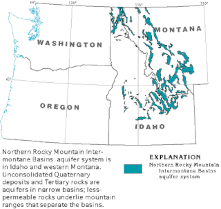
The Northern Rocky Mountain Intermontane Basins aquifer system is composed largely of unconsolidated sand lying under western Montana, Idaho and a small part of Washington. These shallow aquifers are not connected as a whole, body of water, but narrow glacial deposits unified by a common geologic history.
The geology of Maine is part of the broader geology of New England and eastern North America.