
Deception Pass is a strait separating Whidbey Island from Fidalgo Island, in the northwest part of the U.S. state of Washington. It connects Skagit Bay, part of Puget Sound, with the Strait of Juan de Fuca. A pair of bridges known collectively as Deception Pass Bridge cross Deception Pass. The bridges were added to the National Register of Historic Places in 1982.

Captain George Vancouver was a British Royal Navy officer best known for his 1791–1795 expedition, which explored and charted North America's northwestern Pacific Coast regions, including the coasts of what are now the Canadian province of British Columbia and the U.S. states of Alaska, Washington, Oregon, and California. The expedition also explored the Hawaiian Islands and the southwest coast of Australia.

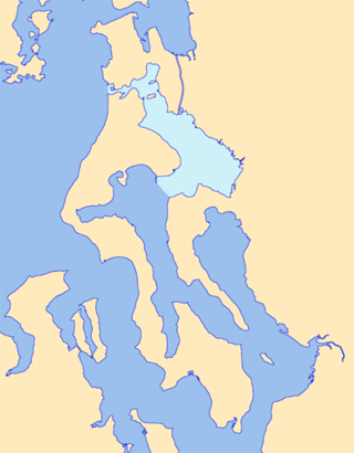
Puget Sound is a sound on the northwestern coast of the U.S. state of Washington. It is a complex estuarine system of interconnected marine waterways and basins. A part of the Salish Sea, Puget Sound has one major and two minor connections to the Strait of Juan de Fuca, which in turn connects to the open Pacific Ocean. The major connection is Admiralty Inlet; the minor connections are Deception Pass and the Swinomish Channel.

Whidbey Island is the largest of the islands composing Island County, Washington, in the United States, and the largest island in Washington state. Whidbey is about 30 miles (48 km) north of Seattle, and lies between the Olympic Peninsula and the I-5 corridor of western Washington. The island forms the northern boundary of Puget Sound. It is home to Naval Air Station Whidbey Island. The state parks and natural forests are home to numerous old growth trees.

Island County is a county located in the U.S. state of Washington. As of the 2020 census, its population was 86,857. Its county seat is Coupeville, while its largest city is Oak Harbor.

Camano Island is a large island in Possession Sound, a section of Puget Sound. It is part of Island County, Washington, and is located between Whidbey Island and the mainland by the Saratoga Passage to the west and Port Susan and Davis Slough to the east. The island has one road connection to the mainland, via State Route 532 over the Camano Gateway Bridge at the northeast end of the island, connecting to the city of Stanwood.
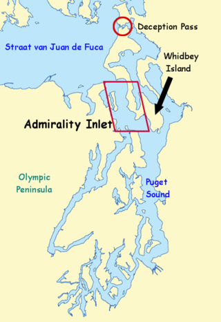
Admiralty Inlet is a strait in the U.S. state of Washington connecting the eastern end of the Strait of Juan de Fuca to Puget Sound. It lies between Whidbey Island and the northeastern part of the Olympic Peninsula.

The Strait of Georgia or the Georgia Strait is an arm of the Salish Sea between Vancouver Island and the extreme southwestern mainland coast of British Columbia, Canada, and the extreme northwestern mainland coast of Washington, United States. It is approximately 240 kilometres (150 mi) long and varies in width from 20 to 58 kilometres. Along with the Strait of Juan de Fuca and Puget Sound, it is a constituent part of the Salish Sea.

Mukilteo Lighthouse Park encompasses the lighthouse at the west end of the city of Mukilteo, Washington, and 12 acres (0.049 km2) south of it. The property is west and south of the Washington State Ferries terminal with ferry service to Clinton, Whidbey Island, and is bordered on the south and east by the BNSF Railway mainline. Whidbey Island lies across a narrow portion of Possession Sound and is easily visible from the shore.
Point Partridge is the most westerly point of Whidbey Island, the largest island in Puget Sound. The point lies north of the Fort Ebey military reservation and south of West Beach. The primary importance of Point Partridge is as the northern and eastern reference point for the dividing line between Puget Sound and the Strait of Juan de Fuca. The other reference is Point Wilson.

Possession Sound is part of Puget Sound, located in the U.S. state of Washington between Whidbey Island and the shoreline of Snohomish County approximately between the cities of Everett and Mukilteo. Possession Sound connects the main Puget Sound basin to the south with Saratoga Passage and Port Susan to the north. The Snohomish River flows into Possession Sound at Port Gardner Bay. Gedney Island, also called Hat Island, is located in Possession Sound.

Port Gardner, also known as Port Gardner Bay, is an inlet of Possession Sound on which the city of Everett, Washington is located. The Snohomish River flows into the north end of the bay.
The Vancouver Expedition (1791–1795) was a four-and-a-half-year voyage of exploration and diplomacy, commanded by Captain George Vancouver of the Royal Navy. The British expedition circumnavigated the globe and made contact with five continents. The expedition at various times included between two and four vessels, and up to 153 men, all but 6 of whom returned home safely.

Saratoga Passage lies in Puget Sound between Whidbey Island and Camano Island.
Skagit Bay is a bay and strait located in the U.S. state of Washington. It is part of the Whidbey Island Basin of Puget Sound. The Skagit River empties into Skagit Bay. To the south, Skagit Bay connects with the rest of Puget Sound via Saratoga Passage and Possession Sound. The boundary between Saratoga Passage and Skagit Bay is between Polnell Point on Whidbey Island and Rocky Point on Camano Island. To the northwest, Skagit Bay connects to the Strait of Juan de Fuca via the narrow strait of Deception Pass. A third waterway, the Swinomish Channel, connects Skagit Bay with Padilla Bay to the north.
Eld Inlet is an inlet located at the southern end of Puget Sound in Thurston County, Washington. It is the second southernmost arm of Puget Sound after neighboring Budd Inlet.

The Puget Sound region is a coastal area of the Pacific Northwest in the U.S. state of Washington, including Puget Sound, the Puget Sound lowlands, and the surrounding region roughly west of the Cascade Range and east of the Olympic Mountains. It is characterized by a complex array of saltwater bays, islands, and peninsulas carved out by prehistoric glaciers.

Glacial erratic boulders in Island County are a remnant of the Pleistocene glaciation that created Puget Sound and transformed the surfaces of what are now Island County's main landmasses: Whidbey Island and Camano Island. South of Deception Pass, the two islands' surfaces and beaches are completely composed of glacial till. Abundant glacial erratic boulders lie on the islands, their beaches, and under the near-shore waters.
The Camano–Whidbey ferry is a historic and proposed ferry route across Saratoga Passage on Puget Sound linking Camano Island and Whidbey Island, the titular islands of Island County, Washington.
Davis Slough is a waterway on the Puget Sound in the state of Washington. The slough runs between Camano and Leque islands, connecting Skagit Bay in the north to Port Susan in the south.
