Pierce County is a county in the U.S. state of Washington. As of the 2020 census, the population was 921,130, up from 795,225 in 2010, making it the second-most populous county in Washington, behind King County, and the 60th-most populous in the United States. The county seat and largest city is Tacoma. Formed out of Thurston County on December 22, 1852, by the legislature of Oregon Territory, it was named for U.S. President Franklin Pierce. Pierce County is in the Seattle metropolitan area.

Fife is a city in Pierce County, Washington, United States and a suburb of Tacoma. The population was 10,999 at the 2020 census. Fife is contained within the Puyallup Indian Reservation.

Midland is a census-designated place (CDP) in Pierce County, Washington. The population was 9,962 at the time of the 2020 census.

Puyallup is a city in Pierce County, Washington, United States, located about 10 miles southeast of Tacoma and 35 miles south of Seattle. It had a population of 42,973 at the 2020 census. The city's name comes from the Puyallup Tribe of Native Americans and means "the generous people." Puyallup is home to the Washington State Fair, the state's largest fair. The name of the city is notably used in mailing addresses for adjacent unincorporated areas, such as the larger-populated South Hill.

The Puyallup, spuyaləpabš or S’Puyalupubsh are a federally recognized Coast Salish Native American tribe from western Washington state, United States. They were relocated onto reservation lands in what is today Tacoma, Washington, in late 1854, after signing the Treaty of Medicine Creek with the United States. Today they have an enrolled population of 6,700, of whom 3,000 live on the reservation.

The Green River is a 65-mile (105 km) long river in the state of Washington in the United States, arising on the western slopes of the Cascade Range south of Interstate 90.

The White River is a white, glacial river in the U.S. state of Washington. It flows about 75 miles (121 km) from its source, the Emmons Glacier on Mount Rainier, to join the Puyallup River at Sumner. It defines part of the boundary between King and Pierce counties.
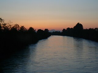
The Puyallup River is a river in the U.S. state of Washington. About 45 miles (72 km) long, it is formed by glaciers on the west side of Mount Rainier. It flows generally northwest, emptying into Commencement Bay, part of Puget Sound. The river and its tributaries drain an area of about 948 square miles (2,460 km2) in Pierce County and southern King County.

Commencement Bay is a bay of Puget Sound in the U.S. state of Washington. The city of Tacoma is located on the bay, with the Port of Tacoma occupying the southeastern end. A line drawn from Point Defiance in the southwest to Browns Point in the northeast serves to mark the generally accepted division between the bay and the open sound. Commencement Bay has become home to one of the most active commercial ports in the world. The Port of Tacoma is the main port facility.
State Route 167 (SR 167) is a state highway in the Seattle metropolitan area of Washington state. It is commonly known as the Valley Freeway and serves the Green River Valley from Tacoma to Renton, primarily as a four-lane freeway. The 28-mile (45 km) highway begins in Tacoma at an interchange with Interstate 5 (I-5) and travels southeast to Puyallup as an undivided road. It then turns northeast onto a freeway and passes through interchanges with SR 512 in Puyallup and SR 410 in Sumner, continuing north through Auburn and Kent. After an interchange with I-405 in Renton, it terminates at an intersection with SR 900.

Kapowsin is a census-designated place located approximately 25 miles southeast of Tacoma in Pierce County, Washington, United States. The 2020 Census placed the population at 249.

State Route 161 (SR 161) is a 36.25-mile-long (58.34 km) state highway serving Pierce and King counties in the U.S. state of Washington. The highway begins at SR 7 southwest of Eatonville and travels north as Meridian Avenue to Puyallup, becoming concurrent with SR 512 and SR 167. SR 161 continues northwest as the Enchanted Parkway to end at an intersection with SR 18 in Federal Way, west of Interstate 5 (I-5). The highway serves the communities of Graham and South Hill before reaching Puyallup and the communities of Edgewood, Milton, and Lakeland South before reaching Federal Way.

The Daffodil Festival is a regional festival and royalty leadership program. The Grand Floral Parade is held in Pierce County, Washington every April. It consists of a flower parade and a year-long royalty program to select a festival queen from one of the 24 area high schools. Each year, the Royal Court spend thousands of hours promoting education, community pride and volunteerism in the county. In 2012, the Royal Court was named the "Official Ambassadors of Pierce County" by the County Executive and the Pierce County Council.

The Port of Tacoma is an independent seaport located in Tacoma, Washington. The port was created by a vote of Pierce County citizens on November 5, 1918. The Edmore was the first ship to call at the port in 1921. The port's marine cargo operations, among the largest in the United States, was merged with the Port of Seattle's in 2015 to form the Northwest Seaport Alliance.
Alderton is a census-designated place (CDP) in Pierce County, Washington, United States. The population was 2,893 at the 2010 census. The community is located in the Puyallup River Valley between the cities of Sumner and Orting.

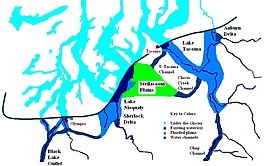
Lake Nisqually is used to identify the freshwater lake formed in the Puget Sound trough, west of Tacoma. It is sometime confused with Early Lake Russell which covered the same area during a previous northward retreat of the glacier. The glacier returned southward, then on its final retreat northward, the waters filing this basin are referred to as Lake Nisqually. Its discharge was across the Black Lake channel at 160 feet (49 m) above sea level. Two deltas formed along the eastern margin of the lake from the outflow of Lake Tacoma in the Puyallup River valley. Both the Steilacoom and Sequalichew deltas, at 160 feet (49 m). A rise in level to 180 to 200 feet reflects the closure of the Black Lake outlet while the two deltas were still growing.
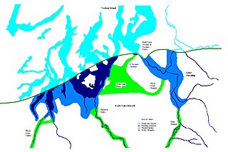
Lake Puyallup developed along the south edge of the Puget Sound Glacier. The glacier was in retreat northward after having reached its most southerly point. Drainage off the north face of Mount Rainier and the melting ice of the glacier was trapped in the valley of the Puyallup River. As the glacier moved north, the lake grew until it reached its largest capacity with the glacier at the glacial front across the Puyallup valley just south of Commencement Bay at Tacoma and northern bend of the White River at Auburn. When the ice retreated further north, it was reduced in depth and volume and takes on the name of Lake Tacoma.