
The Alaska Peninsula National Wildlife Refuge is a United States National Wildlife Refuge in southwestern Alaska whose use is regulated as an ecological-protection measure. It stretches along the southern coast of the Alaska Peninsula, between the Becharof National Wildlife Refuge on its east and the end of the peninsula at False Pass in the west. In between, however, it is broken into sections by lands of the Aniakchak National Monument and Izembek National Wildlife Refuge. The refuge is administered from offices in King Salmon, Alaska and was established to conserve Alaska Peninsula brown bears, caribou, moose, marine mammals, shorebirds, other migratory birds and fish, and to comply with treaty obligations.

The Arapaho National Wildlife Refuge is a United States National Wildlife Refuge located in north-central Colorado. It is one of over 560 national wildlife refuges which manages and protects natural resources for future generations. The refuge is located in North Park in central Jackson County south of the town of Walden. The refuge was established in 1967 to furnish waterfowl with a suitable place to nest and rear their young. It was created in part to offset losses of nesting habitat in the prairie wetland region of the Midwest. It is located in the valley of the Illinois River, a tributary of the North Platte River. It is administered by the United States Fish and Wildlife Service.

Browns Park National Wildlife Refuge is a 13,450-acre (5,440 ha) U.S. National Wildlife Refuge located in northwestern Colorado. It is located in Moffat County in the extreme northwestern corner of the state, in an isolated mountain valley of Browns Park on both sides of the Green River, approximately 25 miles (40 km) below Flaming Gorge Dam. Established in 1965, the refuge is managed by the United States Fish and Wildlife Service office in Maybell, Colorado. The refuge is approximately 53 miles (85 km) northwest of Maybell on State Highway 318. The refuge consists of bottomland and adjacent benchland. The western border of the refuge is the Colorado-Utah state line. The refuge is surrounded by adjacent lines of the Bureau of Land Management. The refuge contains the site of the former Fort Davy Crockett that was constructed in 1837 to protect trappers against attacks by Blackfoot Native Americans.

Ridgefield National Wildlife Refuge is a National Wildlife Refuge and is overseen by the United States Fish and Wildlife Service. The refuge borders the Columbia River and is located west of the city of Ridgefield, Washington. The wildlife haven is split by Lake River. The refuge, which provides a year-round habitat and a migration stop for a variety of bird species, protects more than 5,200 acres (2,100 ha) of marshes, grasslands, and woodlands

Benton Lake National Wildlife Refuge is a 12,459-acre (5,042 ha) National Wildlife Refuge (NWR) in the central part of the U.S. state of Montana.

Swan River National Wildlife Refuge is a 1,778-acre (720 ha) National Wildlife Refuge in Lake County of northwestern Montana. It is a unit of the National Bison Range Complex.
The Yazoo National Wildlife Refuge is a 12,941 acre (52.4 km2) National Wildlife Refuge located in Washington County, Mississippi. Named after the Yazoo tribe, it was established to provide waterfowl and other migratory birds in the Mississippi Flyway with nesting, feeding, brooding, and resting habitat.

Baskett Slough National Wildlife Refuge is in northwestern Oregon, 10 miles (16 km) west of Salem in Polk County. The Refuge consists of 1,173 acres (4.75 km2) of cropland, which provide forage for wintering geese, 300 acres (1.2 km2) of forests, 550 acres (2.2 km2) of grasslands, and 500 acres (2.0 km2) of shallow water seasonal wetlands and 35 acres (0.14 km2) of permanent open water. In 1965, Baskett Slough National Wildlife Refuge was created to help ensure some of the original habitat remained for species preservation. The refuge is managed by the U.S. Fish and Wildlife Service, an agency of the U.S. Department of the Interior.
Grays Lake is a wetland in Idaho, United States. It lies in Bonneville County and Caribou County. Grays Lake National Wildlife Refuge was established in the area in 1965. Ranching is the predominant use of surrounding lands.

The Turnbull National Wildlife Refuge is located six miles (10 km) south of Cheney, Washington, on the eastern edge of the Columbia Basin in Spokane County in northeastern Washington. Turnbull NWR encompasses more than 23,000 acres (9,300 ha) of the Channeled Scablands. The ecosystem that predominates the refuge is unique within the National Wildlife Refuge System and has characteristics that distinguish it from natural reserves worldwide. The combination of basalt outcrops, channeled canyons, and ponderosa pine forests infused in a diverse landscape of over 130 marshes, wetlands, and lakes creates an environment of aesthetic beauty as well as high quality wildlife habitat. The refuge is named for Cyrus Turnbull who lived on the site in the 1880s.
The San Luis National Wildlife Refuge Complex is located in the northern San Joaquin Valley, within Merced County and Stanislaus County of California. The complex, with four federal National Wildlife Refuges, is managed by the U.S Fish & Wildlife Service.
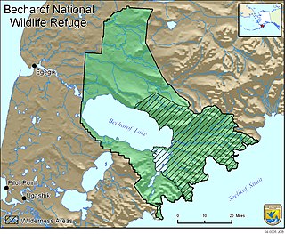
Becharof National Wildlife Refuge is a National Wildlife Refuge in the Aleutian Range of the Alaska Peninsula of southwestern Alaska. It is adjacent to Katmai National Park and Preserve. This national wildlife refuge, which covers an area of 1,200,000 acres (4,900 km2), was established in 1980 to conserve major brown bears, salmon, migratory birds, caribou, marine birds, and mammals and to comply with treaty obligations. It lies primarily in the east-central part of Lake and Peninsula Borough, but extends eastward into the mainland portion of Kodiak Island Borough. The refuge is administered from offices in King Salmon.

The Bill Williams River National Wildlife Refuge protects the lower course of the Bill Williams River, to its mouth at Lake Havasu reservoir, in western Arizona. It is located within eastern La Paz and Mohave Counties, in the Lower Colorado River Valley region.
About half of the Camas National Wildlife Refuge in southeastern Idaho consists of lakes, ponds, and marshlands; the remainder is grass sagebrush uplands, meadows, and farm fields. Camas Creek flows through the length of the refuge.

Mackay Island National Wildlife Refuge was established in 1960 to provide habitat for migratory waterfowl, primarily the greater snow goose. It is located almost entirely on Knotts Island in the Currituck Sound between Back Bay in Virginia Beach, Virginia, and the open sound in North Carolina. Most of the refuge lies within North Carolina but some of it is in Virginia. The refuge is primarily made up of marsh habitat. This area has long been recognized for supporting significant migratory waterfowl populations and sport fishery resources, and is part of the Charles Kuralt Trail.
The Pierce National Wildlife Refuge is in southwest Washington within the Columbia River Gorge National Scenic Area. It encompasses wetlands and uplands along the north shore of the Columbia River west of the town of North Bonneville. Refuge habitats include wetlands, Columbia River riparian corridor blocks, transitional woodlands from willows to cottonwood/ash to white oak to Douglas fir, improved pastures with some native grasses, and numerous creeks, seeps, and springs.
Toppenish National Wildlife Refuge is located on the Yakama Indian Reservation about 6 miles south of Toppenish, Washington, in the agriculturally intensive Yakima Valley of eastern Washington state. Using the waters of Toppenish and Snake Creeks and supplemented with summer irrigation, managers are able to provide a mosaic of refuge wetlands interspersed with lush riparian and native upland habitats.
Cold Springs National Wildlife Refuge is a 3,117-acre (12.61 km2) National Wildlife Refuge located 7 miles (10 km) northeast of Hermiston and 3 miles (5 km) south of the Columbia River in Umatilla County, Oregon; The refuge was established in 1909 as a preserve and breeding ground for native birds. It consists of diverse wetland habitats surrounded by upland habitat of big sagebrush and native steppe grasses. A riparian component of willow and cottonwood provides refuge for birds, mammals, and other animals.

The Summer Lake Wildlife Area is a 29.6-square-mile (77 km2) wildlife refuge located on the northwestern edge of the Great Basin drainage in south-central Oregon. It is administered by the Oregon Department of Fish and Wildlife. The refuge is an important stop for waterfowl traveling along the Pacific Flyway during their spring and fall migrations. The Summer Lake Wildlife Area also provides habitat for shorebirds and other bird species as well as wide variety of mammals and several fish species. The Ana River supplies the water for the refuge wetlands.

The ecology of the Rocky Mountains is diverse due to the effects of a variety of environmental factors. The Rocky Mountains are the major mountain range in western North America, running from the far north of British Columbia in Canada to New Mexico in the southwestern United States, climbing from the Great Plains at or below 1,800 feet (550 m) to peaks of over 14,000 feet (4,300 m). Temperature and rainfall varies greatly also and thus the Rockies are home to a mixture of habitats including the alpine, subalpine and boreal habitats of the Northern Rocky Mountains in British Columbia and Alberta, the coniferous forests of Montana and Idaho, the wetlands and prairie where the Rockies meet the plains, a different mix of conifers on the Yellowstone Plateau in Wyoming, the montane forests of Utah, and in the high Rockies of Colorado and New Mexico, and finally the alpine tundra of the highest elevations.

