Arlington is a city in northern Snohomish County, Washington, United States, part of the Seattle metropolitan area. The city lies on the Stillaguamish River in the western foothills of the Cascade Range, adjacent to the city of Marysville. It is approximately 10 miles (16 km) north of Everett, the county seat, and 40 miles (64 km) north of Seattle, the state's largest city. As of the 2020 U.S. census, Arlington had a population of 19,868; its estimated population is 20,075 as of 2021.

The Olympic Peninsula is a large arm of land in western Washington that lies across Puget Sound from Seattle, and contains Olympic National Park. It is bounded on the west by the Pacific Ocean, the north by the Strait of Juan de Fuca, and the east by Hood Canal. Cape Alava, the westernmost point in the contiguous United States, and Cape Flattery, the northwesternmost point, are on the peninsula. Comprising about 3,600 square miles (9,300 km2), the Olympic Peninsula contained many of the last unexplored places in the contiguous United States. It remained largely unmapped until Arthur Dodwell and Theodore Rixon mapped most of its topography and timber resources between 1898 and 1900.
Olympic National Forest is a U.S. National Forest located in Washington, USA. With an area of 628,115 acres (2,541.89 km2), it nearly surrounds Olympic National Park and the Olympic Mountain range. Olympic National Forest contains parts of Clallam, Grays Harbor, Jefferson, and Mason counties. The landscape of the national forest varies, from the temperate Olympic rain forest to the salt water fjord of Hood Canal to the peaks of Mt. Washington.

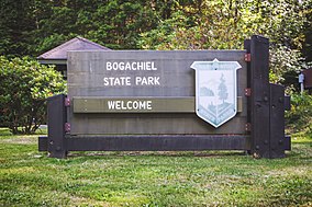
The Bogachiel River is a river of the Olympic Peninsula in the U.S. state of Washington. It originates near Bogachiel Peak, flows west through the mountains of Olympic National Park. After emerging from the park it joins the Sol Duc River, forming the Quillayute River, which empties into the Pacific Ocean near La Push, Washington.
Blake Island is a Puget Sound island in Kitsap County, Washington, United States, that is preserved as Blake Island Marine State Park. The island lies north of Vashon Island, south of Bainbridge Island, and east of Manchester. On the northeast end of the island is Tillicum Village, a showcase for Northwest Coast Indian arts, culture, and food. The park is managed by the Washington State Parks and Recreation Commission.

The George Washington and Jefferson National Forests is an administrative entity combining two U.S. National Forests into one of the largest areas of public land in the Eastern United States. The forests cover 1.8 million acres (7,300 km2) of land in the Appalachian Mountains of Virginia, West Virginia, and Kentucky. Approximately 1 million acres (4,000 km2) of the forest are remote and undeveloped and 139,461 acres (564 km2) have been designated as wilderness areas, which prohibits future development.

Manchester State Park is a 111-acre (45 ha) state park in Kitsap County, Washington, United States. It is situated on the east side of the Kitsap Peninsula with 3,400 feet (1,000 m) of shoreline facing Puget Sound. It was at one time a harbor defense installation for the nearby Bremerton, then a fuel supply depot and U.S. Navy fire-fighting station. The park contains a former torpedo warehouse, a mining casement, and a gun battery. Park activities include picnicking, camping, boating, fishing, hiking on 1.9 miles (3.1 km) of trails, birdwatching, volleyball, wildlife viewing, and horseshoes.

Fay Bainbridge Park is a locally operated, public recreation area situated immediately south of the Point Monroe sandspit on the northeast tip of Bainbridge Island, Washington and is open from dawn to dusk. The park comprises 17 acres (6.9 ha) of land, including 1,420 feet (430 m) of shoreline on Puget Sound.The park offers beach activities and camping in addition to views of Puget Sound, the Cascade Mountains and two volcanoes: Mount Rainier and Mount Baker.

Moran State Park is a public recreation area on Orcas Island in Puget Sound's San Juan Islands in the state of Washington, United States. The state park encompasses over 5,000 acres of various terrain including forests, wetlands, bogs, hills, and lakes. It is the largest public recreation area in the San Juan Islands and the fourth largest state park in the state. A park focal point is the observation tower atop Mount Constitution, the highest point in San Juan County at 2,407 feet.

Olallie State Park is a public recreation area featuring multiple waterfalls located five miles (8.0 km) southeast of North Bend, Washington. The state park spans a 3.5-mile (5.6 km) stretch along the South Fork of the Snoqualmie River. The most prominent feature of the park is 135-foot-high (41 m) Twin Falls.

The Sol Duc River is a river in the U.S. state of Washington. About 78 miles (126 km) long, it flows west through the northwest part of the Olympic Peninsula, from the Olympic Mountains of Olympic National Park and Olympic National Forest, then through the broad Sol Duc Valley. Near the Pacific Ocean the Sol Duc River joins the Bogachiel River, forming the Quillayute River, which flows about 4 miles (6.4 km) to the Pacific Ocean at La Push. Although the Quillayute River is short, its large tributary rivers—the Sol Duc, Bogachiel, Calawah, and Dickey Rivers—drain the largest watershed of the northern Olympic Peninsula, 629 square miles (1,630 km2). The Sol Duc's watershed is the largest of the Quillayute's tributaries, at 219 square miles (570 km2).

Mount Spokane State Park is a public recreation area in the northwest United States,located in the Selkirk Mountains, 23 miles (37 km) northeast of the city of Spokane, Washington. The state park surrounds 5,883-foot (1,793 m) Mount Spokane and other peaks including Mount Kit Carson, Beauty Mountain, and Quartz Mountain.

State Route 110 (SR 110) is a 11.10-mile-long (17.86 km) state highway serving Olympic National Park and the Quileute Indian Reservation within Clallam County, located in the U.S. state of Washington. The highway travels west from U.S. Route 101 (US 101) in Forks as La Push Road along the Quileute and Sol Duc rivers to the boundary of Olympic National Park east of La Push. La Push Road was originally added to the state highway system in 1937 as Secondary State Highway 9B (SSH 9B), but was removed in 1955. SR 110 was later established on the route in 1991 after a previous highway with the same designation was removed. A spur route extending west to Mora was originally added with SSH 9B and re-added with SR 110 in 1991.

U.S. Route 101 (US 101) is a United States Numbered Highway that runs along the West Coast from Los Angeles, California to Tumwater, Washington. Within the state of Washington, US 101 connects cities on the coast of the Pacific Ocean and encircles the Olympic Peninsula around the Olympic Mountains. It also serves as the main access for Olympic National Park, several state parks, and other scenic and recreational areas.

Cutts Island State Park is a public recreation area park comprising the entirety of two-acre (0.81 ha) Cutts Island in Carr Inlet in Pierce County, Washington. The island is a clay butte with a stand of trees and a teardrop-shaped beach at low tide. It sits one half-mile offshore from Kopachuck State Park and is accessible only by water and occasionally by sandbar at extremely low tide. Eight mooring buoys are available for boaters. Park activities include beachcombing and scuba diving.

Dosewallips State Park is a public recreation area located where the Dosewallips River empties into Hood Canal in Jefferson County, Washington. The state park's 1,064 acres (431 ha) include both freshwater and saltwater shorelines. The park offers opportunities for picnicking, camping, hiking, boating, fishing, swimming, scuba diving, and shellfish harvesting.
Hope Island State Park - Mason is a Washington state park in Mason County that is accessible only by boat. It consists of 106 acres (43 ha) of old-growth forest and salt marsh with a 1.5-mile (2.4 km) beach on Puget Sound. Park activities include picnicking, camping, hiking, fishing, clamming, beachcombing, and birdwatching. The park has been administered as a satellite of Jarrell Cove State Park, since acquisition from private owners of the island in 1990. Water is not available on the island, and open fires and pets are not permitted.

Rasar State Park ( "racer") is a public recreation area located on the north bank of the Skagit River, eight miles (13 km) west of Concrete in Skagit County, Washington. The state park's 180 acres (73 ha) include 4,000 feet (1,200 m) of river shoreline; it is managed by the Washington State Parks and Recreation Commission.
Doe Island State Park is a public recreation area comprising the entirety of Doe Island, a seven-acre (2.8 ha) island lying some 300 feet (91 m) off the eastern flank of Orcas Island in San Juan County, Washington. It has 2,049 feet (625 m) of shoreline and a trail three-tenths of a mile long that circles the island. It is accessible only by water. Washington State Parks acquired a portion of the island from the Bureau of Land Management in 1964 for $15.27, with a second acquisition in 1967 from DNR for no cost. Activities include camping, boating, fishing, crabbing, birdwatching, and wildlife viewing.