Whychus Creek

Last updated
Whychus Creek
Whychus Creek, Oregon.jpg
Name origin:Native American (Indian) name for the creek, according to 19th-century surveyor, Robert S. Williamson [1]
Country United States
State Oregon
County Deschutes and Jefferson
Source Broken Top, Cascade Range
 - location Deschutes National Forest, Deschutes County
 - elevation7,617 ft (2,322 m) [2]
 - coordinates 44°05′21″N121°41′36″W / 44.08917°N 121.69333°W / 44.08917; -121.69333   [3]
Mouth Deschutes River
 - location Crooked River National Grassland, Jefferson County
 - elevation2,110 ft (643 m) [3]
 - coordinates 44°27′35″N121°20′07″W / 44.45972°N 121.33528°W / 44.45972; -121.33528 Coordinates: 44°27′35″N121°20′07″W / 44.45972°N 121.33528°W / 44.45972; -121.33528   [3]
Basin253 sq mi (655 km2) [4]
USA Oregon location map.svg
Red pog.svg
Location of the mouth of Whychus Creek in Oregon
TypeWild, Scenic
DesignatedOctober 28, 1988

Whychus Creek is a tributary of the Deschutes River in Deschutes and Jefferson counties in the U.S. state of Oregon. [5] Formerly named Squaw Creek, considered derogatory in the 21st century, [1] it was renamed in 2006. [6] Explorer John C. Frémont camped along the stream in 1843 but did not identify it by name. Robert S. Williamson, a surveyor who camped there in 1855, said its Indian (Native American) name was Why-chus. [1]

Deschutes River (Oregon) river in the United States of America

The Deschutes River in central Oregon is a major tributary of the Columbia River. The river provides much of the drainage on the eastern side of the Cascade Range in Oregon, gathering many of the tributaries that descend from the drier, eastern flank of the mountains. The Deschutes provided an important route to and from the Columbia for Native Americans for thousands of years, and then in the 19th century for pioneers on the Oregon Trail. The river flows mostly through rugged and arid country, and its valley provides a cultural heart for central Oregon. Today the river supplies water for irrigation and is popular in the summer for whitewater rafting and fishing.

Deschutes County, Oregon County in the United States

Deschutes County is a county in the U.S. state of Oregon. As of the 2010 census, the population was 157,733. The county seat is Bend. The county was created in 1916 out of part of Crook County and was named for the Deschutes River, which itself was named by French-Canadian trappers of the early 19th century. It is the political and economic hub of Central Oregon.

Jefferson County, Oregon County in the United States

Jefferson County is a county located in the U.S. state of Oregon. As of the 2010 census, the population was 21,720. The county seat is Madras. The county is named after Mount Jefferson.

Contents

Course

Whychus Creek begins about 7,600 feet (2,300 m) above sea level [3] at the base of Bend Glacier on Broken Top in the Cascade Range. [7] Flowing generally north through the Three Sisters Wilderness, the stream plunges over 200-foot (61 m) Upper Chush Falls before receiving Park Creek from the left and plunging over 50-foot (15 m) Chush Falls. [8] Downstream of the waterfalls, the creek receives South Fork and North Fork from the left and Snow Creek from the right. [7]

Broken Top mountain

Broken Top is a glacially eroded complex stratovolcano. It lies in the Cascade Volcanic Arc, part of the extensive Cascade Range in the U.S. state of Oregon. Located southeast of the Three Sisters peaks, the volcano, residing within the Three Sisters Wilderness, is 20 miles (32 km) west of Bend, Oregon in Deschutes County. Eruptive activity stopped roughly 100,000 years ago, and currently, erosion by glaciers has reduced the volcano's cone to where its contents are exposed. There are two named glaciers on the peak, Bend and Crook Glacier.

Cascade Range mountain range in western North America

The Cascade Range or Cascades is a major mountain range of western North America, extending from southern British Columbia through Washington and Oregon to Northern California. It includes both non-volcanic mountains, such as the North Cascades, and the notable volcanoes known as the High Cascades. The small part of the range in British Columbia is referred to as the Canadian Cascades or, locally, as the Cascade Mountains. The latter term is also sometimes used by Washington residents to refer to the Washington section of the Cascades in addition to North Cascades, the more usual U.S. term, as in North Cascades National Park. The highest peak in the range is Mount Rainier in Washington at 14,411 feet (4,392 m).

Three Sisters Wilderness

The Three Sisters Wilderness is a wilderness area in the Cascade Range, within the Willamette and Deschutes National Forests in Oregon, United States. It comprises 286,708 acres (1,160.27 km2), making it the second largest wilderness area in Oregon, after the Eagle Cap Wilderness. It was established by the United States Congress in 1964 and is named for the Three Sisters volcanoes. The wilderness boundary encloses the Three Sisters as well as Broken Top, which is southeast of South Sister.

Turning northeast, the creek intersects Whychus Creek Canal, [7] which diverts water to McKenzie Canyon Reservoir and other parts of the Three Sisters Irrigation District. [9] Flowing by the southeast side of the city of Sisters, Whychus Creek passes under U.S. Route 20 and Oregon Route 126, which overlap in this vicinity, before receiving Indian Ford Creek from the left. Continuing northeast, the creek leaves Deschutes County and enters Jefferson County and the Crooked River National Grassland. [7] The creek empties into the Deschutes River downstream of the city of Redmond and about 123 miles (198 km) from the larger stream's confluence with the Columbia River. [10]

Sisters, Oregon City in Oregon, United States

Sisters is a city in Deschutes County, Oregon, United States. It is part of the Bend, Oregon Metropolitan Statistical Area. The population was 959 at the 2000 census, but more than doubled to 2,038 as of the 2010 census.

U.S. Route 20 in Oregon highway in Oregon

U.S. Route 20 (US 20) is a major west–east cross-state highway in the northern part of the U.S. state of Oregon, especially east of the Cascade Mountains. It connects U.S. Route 101 in Newport on the central Oregon Coast to the Idaho state line east of Nyssa.

Oregon Route 126 State highway in Oregon

Oregon Route 126 is a 204.63-mile-long (329.32 km) state highway that connects coastal, western, and central parts of the U.S. state of Oregon. A short freeway section of Oregon 126 in Eugene and Springfield is concurrent with Interstate 105.

See also

Related Research Articles

Malheur River river in the United States of America

The Malheur River is a 190-mile-long (306 km) tributary of the Snake River in eastern Oregon in the United States. It drains a high desert area, between the Harney Basin and the Blue Mountains and the Snake.

Tumalo Creek river in the United States of America

Tumalo Creek is a tributary, about 20 miles (32 km) long, of the Deschutes River, located in Deschutes County in Central Oregon, United States. It rises in the Cascade Range at 44.04706°N 121.598647°W, where Middle Fork Tumalo Creek and North Fork Tumalo Creek meet, and forms several waterfalls, including the 97-foot (30 m) Tumalo Falls. Its mouth is on the Deschutes at 44.1159506°N 121.3394783°W.

Warm Springs River river in Oregon

The Warm Springs River is a tributary of the Deschutes River in north-central Oregon in the United States. It flows generally southeast along the east side of the Cascade Range. The watershed is approximately between Mount Jefferson and Timothy Lake, and the northwestern and southwestern boundaries of the Warm Springs Indian Reservation coincide with the watershed. The headwaters are less than 14 mile (0.40 km) from the Wasco County–Clackamas County boundary. The river flows generally eastward, with occasional diagonals southeast or northeast. It joins the Deschutes River at river mile 83.7.

Umatilla River tributary of the Columbia River in Oregon

The Umatilla River is an 89-mile (143 km) tributary of the Columbia River in the U.S. state of Oregon. Draining a basin of 2,450 square miles (6,300 km2), it enters the Columbia near the city of Umatilla in the northeastern part of the state. In downstream order, beginning at the headwaters, major tributaries of the Umatilla River are the North Fork Umatilla River and the South Fork Umatilla River, then Meacham, McKay, Birch, and Butter creeks.

Crooked River (Oregon) tributary of the Deschutes River in the U.S. state of Oregon

The Crooked River is a tributary, 125 miles (201 km) long, of the Deschutes River in the U.S. state of Oregon. The river begins at the confluence of the South Fork Crooked River and Beaver Creek. Of the two tributaries, the South Fork Crooked River is the larger and is sometimes considered part of the Crooked River proper. A variant name of the South Fork Crooked River is simply "Crooked River". The Deschutes River flows north into the Columbia River.

Middle Fork Willamette River river in the United States of America

The Middle Fork Willamette River is one of several forks that unite to form the Willamette River in the western part of the U.S. state of Oregon. It is approximately 115 miles (185 km) long, draining an area of the Cascade Range southeast of Eugene, which is at the southern end of the Willamette Valley.

Big Butte Creek river in Oregon, United States of America

Big Butte Creek is a 12-mile-long (19 km) tributary of the Rogue River in the U.S. state of Oregon. It drains approximately 245 square miles (635 km2) of Jackson County. Its two forks, the North Fork and the South Fork, both begin high in the Cascade Range near Mount McLoughlin. Flowing predominantly west, they meet near the city of Butte Falls. The main stem flows generally northwest until it empties into the Rogue Falls was incorporated in 1911, and remains the only incorporated town within the watershed's boundaries.

North Fork Malheur River river in the United States of America

The North Fork Malheur River is a 59-mile (95 km) tributary of the Malheur River in eastern Oregon in the United States. Rising in Big Cow Burn in the Blue Mountains, it flows generally south to join the larger river at Juntura. The upper 25.5 miles (41.0 km) of the river have been designated Wild and Scenic. This part of the river basin offers camping, hiking, and fishing opportunities in a remote forest setting. The lower river passes through Beulah Reservoir, which stores water for irrigation and has facilities for boaters.

South Fork Coquille River river in the United States of America

The South Fork Coquille River is the longest tributary of the Coquille River in coastal Oregon in the United States. From its headwaters in the Southern Oregon Coast Range, the river flows northwest to join the North Fork Coquille River at Myrtle Point, forming the main stem Coquille. The South Fork is about 63 miles (101 km) long, and its watershed drains roughly 288 square miles (750 km2) of rural Coos County.

South Fork Crooked River river in the United States of America

The South Fork Crooked River is a tributary, 76 miles (122 km) long, of the Crooked River in the U.S. state of Oregon. Starting southeast of Hampton in Deschutes County, the South Fork flows east from near Ram Lake (dry). It passes under U.S. Route 20 at Hampton, then continues east and north for about 6 miles (10 km) before entering Crook County. Shortly thereafter, east of Hampton Buttes, it receives Buck Creek from the right and then passes through Logan Reservoir. Flowing north, it receives Sand Hollow Creek from the left, then Twelvemile Creek from the right before crossing under Oregon Route 380. Just north of the highway, the river joins Beaver Creek to form the Crooked River 125 miles (201 km) from its confluence with the Deschutes River.

Winchuck River river in the United States of America

The Winchuck River is a short coastal stream that runs through the Rogue River–Siskiyou National Forest to the Pacific Ocean in the U.S. states of Oregon and California. Flowing generally west from its origin near Elk Mountain, the river enters the sea at Crissey Field State Recreation Site, about 12 mile (0.80 km) north of the Oregon–California border and about 5 miles (8 km) south of Brookings.

Little Luckiamute River river in the United States of America

The Little Luckiamute River is a stream in Polk County in the U.S. state of Oregon. It rises in the Central Oregon Coast Range near Fanno Peak and joins the Luckiamute River about 4 miles (6 km) upstream of the Sarah Helmick State Recreation Site southwest of Monmouth.

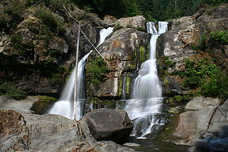
Upper Chush Falls is a 200-foot (61 m) waterfall on Whychus Creek, in the Cascade Range southwest of Sisters in the U.S. state of Oregon. Chush Falls, a 50-foot (15 m) waterfall, is further downstream on the same creek. Lying between Chush and Upper Chush is a third waterfall, The Cascade. These and several other falls on tributaries in the vicinity are within the Three Sisters Wilderness. The Northwest Waterfall Survey lists the fall's average flow at 40 cubic feet per second (1.1 m3/s). The highest flows occur between May and August.

South Fork McKenzie River tributary of the McKenzie River in Oregon

The South Fork McKenzie River is a tributary, about 31 miles (50 km) long, of the McKenzie River in the U.S. state of Oregon. It begins at about 4,500 feet (1,400 m) above sea level near Mink Lake in the Three Sisters Wilderness of the Cascade Range. Flowing northwest within Lane County, it meets the McKenzie River about 60 miles (97 km) from the larger river's confluence with the Willamette River.

Salt Creek (Middle Fork Willamette River tributary) river in the United States of America

Salt Creek is a tributary, 30 miles (48 km) long, of the Middle Fork Willamette River in Lane County in the U.S. state of Oregon. It is named for salt springs along its banks that are used as licks by deer. The stream originates as an outflow of Lower Betty Lake in the forested Cascade Range just southeast of Waldo Lake. From its source, Salt Creek flows generally south, through Gold Lake, to Route 58, which it then follows mainly northwest for about 26 miles (42 km) to its mouth at the Middle Fork Willamette River just below Hills Creek Dam. At Salt Creek Falls—roughly 4 miles (6.4 km) west of Willamette Pass and a little more than 22 miles (35 km) upstream from the mouth—the stream plunges 286 feet (87 m), discharging an average of 50,000 U.S. gallons (190,000 L) of water per minute, or 111 cubic feet per second (3.1 m3/s). Below the falls, the creek enters a narrow canyon shaped by glaciation and basalt lava flows from higher in the Cascades. McCredie Hot Springs, at the former community of McCredie Springs, are natural hot springs along the lower half of Salt Creek beside Route 58.

Spring River (Deschutes River tributary)

The Spring River is a tributary, only about 1 mile (1.6 km) long, of the Deschutes River in Deschutes County in the U.S. state of Oregon. Arising near Anns Butte, it flows generally northeast into the Deschutes at Sunriver, about 190 miles (310 km) from the larger stream's confluence with the Columbia River. The Spring River has no named tributaries.

Chush Falls, also known as Lower Squaw Creek Falls and Lower Whychus Falls, is a waterfall formed along Whychus Creek on the north skirt of North Sister, west side of the city of Bend in Deschutes County, Oregon. Access to Chush Falls is from Forest Service Road 16, south of Highway 242. The trail to the falls ends at the canyon rim overlooking the falls, but unmarked paths lead down to the base of the waterfall.

Camp Lake (Oregon) Lake in Oregon

Camp Lake is a small alpine lake in Deschutes County in the U.S. state of Oregon. It lies between the Middle Sister and South Sister volcanic peaks at about 7,000 feet (2,100 m) above sea level in the Three Sisters Wilderness of the Cascade Range. The Camp Lake Trail skirts the lake along its north shore.

References

  1. 1 2 3 McArthur, Lewis A.; Lewis L. McArthur (2003) [1928]. Oregon Geographic Names (7th ed.). Portland, Oregon: Oregon Historical Society Press. p. 907. ISBN   0-87595-277-1.
  2. Source elevation derived from Google Earth search using GNIS source coordinates.
  3. 1 2 3 4 "Whychus Creek". Geographic Names Information System (GNIS). United States Geological Survey. November 28, 1980. Retrieved May 1, 2012.
  4. Upper Deschutes Watershed Council (2009). "Whychus Creek Restoration Monitoring Plan" (PDF). Upper Deschutes Watershed Council. p. 1. Retrieved May 1, 2012.
  5. "Whychus Creek". Geographic Names Information System . United States Geological Survey. November 28, 1980. Retrieved August 4, 2011.
  6. "Sisters Country Timeline". Sisters Country Historical Society. 1996. Retrieved May 1, 2012.
  7. 1 2 3 4 Oregon Atlas & Gazetteer. Freeport, Maine: DeLorme Mapping. 1991. p. 50. ISBN   0-89933-235-8.
  8. Anderson, David L. (2007). Waterfalls of the Pacific Northwest. Woodstock, Vermont: The Countryman Press. pp. 183&ndash, 85. ISBN   978-0-88150-713-3.
  9. "Who We Are". Three Rivers Irrigation District. Retrieved May 1, 2012.
  10. United States Geological Survey (USGS). "United States Geological Survey Topographic Map". TopoQuest. Retrieved May 1, 2012. The map quadrangles include river mile (RM) markers along the Deschutes River.
United States Bureau of Reclamation government agency

The United States Bureau of Reclamation (USBR), and formerly the United States Reclamation Service, is a federal agency under the U.S. Department of the Interior, which oversees water resource management, specifically as it applies to the oversight and operation of the diversion, delivery, and storage projects that it has built throughout the western United States for irrigation, water supply, and attendant hydroelectric power generation. Currently the USBR is the largest wholesaler of water in the country, bringing water to more than 31 million people, and providing one in five Western farmers with irrigation water for 10 million acres of farmland, which produce 60% of the nation's vegetables and 25% of its fruits and nuts. The USBR is also the second largest producer of hydroelectric power in the western United States.

Oregon Public Broadcasting non-profit organisation in the USA

Oregon Public Broadcasting (OPB) is the primary television and radio public broadcasting network for most of the U.S. state of Oregon as well as southern Washington. OPB consists of five full-power television stations, dozens of VHF or UHF translators, and over 20 radio stations and frequencies. Broadcasts include local and regional programming as well as television programs from the Public Broadcasting Service (PBS) and American Public Television (APT), and radio programs from National Public Radio (NPR), Public Radio International (PRI), American Public Media (APM), Public Radio Exchange (PRX), and the BBC World Service, among other distributors. Its headquarters and television studios are located in Portland.

<i>Oregon Field Guide</i> television series

Oregon Field Guide is a weekly television program produced by Oregon Public Broadcasting focusing on recreation, the outdoors, and environmental issues in the state of Oregon. The show has become part of the Oregon zeitgeist. Steve Amen is the show's host and executive producer. Named for the field guides used to identify plants, animals, and natural phenomenon, the wide-ranging series covers Oregon natural history, outdoor recreation, conservation, agriculture, rural life, and other local subjects. Produced with deep narratives rather than short segments, 13 half-hour and one full-hour episodes are shown per year.