The Muscogee, also known as the Mvskoke, Muscogee Creek or just Creek, and the Muscogee Creek Confederacy, are a group of related Indigenous peoples of the Southeastern Woodlands in the United States. Their historical homelands are in what now comprises southern Tennessee, much of Alabama, western Georgia and parts of northern Florida.

Holmes County is a county located in the northwestern part of the U.S. state of Florida, in the Panhandle. As of the 2020 census, the population was 19,653. Its county seat is Bonifay.

Walton County is a county located on the Emerald Coast in the northwestern part of the U.S. state of Florida, with its southern border on the Gulf of Mexico. As of the 2020 census, the population was 75,305. Its county seat is DeFuniak Springs. The county is home to the highest natural point in Florida: Britton Hill, at 345 feet (105 m). Walton County is included in the Crestview–Fort Walton Beach–Destin Metropolitan Statistical Area.

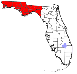
The Florida panhandle is the northwestern part of the U.S. state of Florida. It is a salient roughly 200 miles (320 km) long, bordered by Alabama on the north and the west, Georgia on the north, and the Gulf of Mexico to the south. Its eastern boundary is arbitrarily defined. It is defined by its southern culture and rural geography relative to the rest of Florida, as well as closer cultural links to French-influenced Louisiana, Mississippi, and Alabama. Its major communities include Pensacola, Navarre, Destin, Panama City Beach, and Tallahassee.

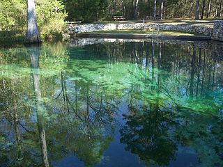
Ponce de Leon Springs State Recreation Area is a Florida State Park in Holmes County, Florida, USA. It is located in the town of Ponce de Leon. The park, which was created to provide public outdoor recreation and other park-related uses, was initially acquired on September 4, 1970, using funds from the Land Acquisition Trust Fund. Its self-proclaimed purpose is to develop, operate and maintain the property for outdoor recreation, park, historic, and related purposes, offering abundant opportunity for nature appreciation and wildlife viewing. Its primary recreational activities include swimming in the spring and hiking along the park's nature trails.

The Yuchi people are a Native American tribe based in Oklahoma, though their original homeland was in the southeastern United States.

The Choctawhatchee River is a 141-mile-long (227 km) river in the southern United States, flowing through southeast Alabama and the Panhandle of Florida before emptying into Choctawhatchee Bay in Okaloosa and Walton counties. The river, the bay and their adjacent watersheds collectively drain 5,350 square miles (13,900 km2).

The Fort Walton Mound (8OK6) is an archaeological site located in present-day Fort Walton Beach, Florida, United States. The large platform mound was built about 850 CE by the Pensacola culture, a local form of the Mississippian culture. Because of its significance, the mound was designated a National Historic Landmark in 1964.
The Dominickers are a small biracial or triracial ethnic group that was once centered in the Florida Panhandle county of Holmes, in a corner of the southern part of the county west of the Choctawhatchee River, near the town of Ponce de Leon. The group was classified in 1950 as one of the "reputed Indian-White-Negro racial isolates of the Eastern United States" by the United States Census Bureau.
The Treaty of Moultrie Creek, also known as the Treaty with the Florida Tribes of Indians, was an agreement signed in 1823 between the government of the United States and the chiefs of several groups and bands of Indians living in the present-day state of Florida. The treaty established a reservation in the center of the Florida peninsula. It also ceded all coastal lands to the United States Government, as the U.S. wanted control of overseas trade between the Florida and the Caribbean.

The history of Oklahoma refers to the history of the state of Oklahoma and the land that the state now occupies. Areas of Oklahoma east of its panhandle were acquired in the Louisiana Purchase of 1803, while the Panhandle was not acquired until the U.S. land acquisitions following the Mexican–American War (1846–1848).
Grayton Beach is a small, historic beach village on the Florida Panhandle Gulf coast halfway between Destin and Panama City in Walton County and adjacent to Grayton Beach State Park. Collectively, the area is known as the “Beaches of South Walton", with South Walton referring to the southern portion of Walton County below the Choctawhatchee Bay.

Volusia is an unincorporated community in Volusia County, Florida, United States, on the eastern shore of the St. Johns River. It is about three miles south of Lake George and across the river from the town of Astor in Lake County. Established by Spanish missionaries, Volusia is one of the oldest European settlements in Florida. The main route through the town is State Road 40, which crosses the St. Johns on the Astor Bridge.
The Chisca were a tribe of Native Americans living in present-day eastern Tennessee and southwestern Virginia in the 16th century. Their descendants, the Yuchi lived in present-day Alabama, Georgia, and Florida in the 17th, 18th, and early 19th centuries, and were removed to Indian Territory in the 1830s.
The Northwest Florida Water Management District (NWFWMD) stretches from the St. Marks River Basin in Jefferson County to the Perdido River in Escambia County. The District is one of five water management districts in Florida created by the Water Resources Act of 1972. The District has worked for decades to protect and manage water resources in a sustainable manner for the continued welfare of people and natural systems across its 16-county region. It serves Bay, Calhoun, Escambia, Franklin, Gadsden, Gulf, Holmes, Jackson, Leon, Liberty, Okaloosa, Santa Rosa, Wakulla, Walton, Washington and western Jefferson Counties.

Choctawhatchee Bay is a bay in the Emerald Coast region of the Florida Panhandle. The bay, located within Okaloosa and Walton counties, is an inlet of the Gulf of Mexico and has a surface area of 334 square kilometres (129 sq mi). It connects to Santa Rosa Sound in Fort Walton Beach, Florida to the west and to St. Andrews Bay in Bay County to the east, via the Gulf Intracoastal Waterway. East Pass is the only outlet of the bay flowing directly into the Gulf of Mexico, and is crossed by US 98. The Choctawhatchee River flows into the bay, as do several smaller rivers and streams. The tolled Mid-Bay Bridge crosses the bay, connecting the city of Destin to Niceville, Florida. The Judge Clyde B. Wells Bridge crosses the eastern part of the bay, connecting Freeport to the coast.
Neil McLennan was an early Scottish-American settler of Texas. McLennan County, Texas, was named for him.
Uchee Billy or Yuchi Billy was a chief of a Yuchi band in Florida during the first half of the 19th century. Uchee Billy's band was living near Lake Miccosukee when Andrew Jackson invaded Spanish Florida during the First Seminole War and attacked the villages in the area. Yuchi Billy and his band then moved to the St. Johns River. During the Second Seminole War, Uchee Billy was an ally of the Seminoles, and was one of the principal war chiefs who fought the U.S. Army.
John Forbes (1767–1823) and his elder brother Thomas Forbes (d.1808) were Scottish traders who operated in East Florida, West Florida, Spanish Florida and the southeastern borderlands during the tail end of the eighteenth century. John Forbes & Company took control of the assets of its precursor trading firm, Panton, Leslie & Company, after William Panton died in 1801, followed by John Leslie in 1803.
Eucheeanna, also known as Euchee Anna, is an unincorporated community in Walton County, in the U.S. state of Florida. It was the county seat from 1845, when Florida became a state, until 1885 when its courthouse burned and the county was moved several miles away to DeFuniak Springs.