
Coastal erosion is the loss or displacement of land, or the long-term removal of sediment and rocks along the coastline due to the action of waves, currents, tides, wind-driven water, waterborne ice, or other impacts of storms. The landward retreat of the shoreline can be measured and described over a temporal scale of tides, seasons, and other short-term cyclic processes. Coastal erosion may be caused by hydraulic action, abrasion, impact and corrosion by wind and water, and other forces, natural or unnatural.

A groyne is a rigid hydraulic structure built perpendicularly from an ocean shore or a river bank, interrupting water flow and limiting the movement of sediment. It is usually made out of wood, concrete, or stone. In the ocean, groynes create beaches, prevent beach erosion caused by longshore drift where this is the dominant process and facilitate beach nourishment. There is also often cross-shore movement which if longer than the groyne will limit its effectiveness. In a river, groynes slow down the process of erosion and prevent ice-jamming, which in turn aids navigation.

Beach nourishment describes a process by which sediment, usually sand, lost through longshore drift or erosion is replaced from other sources. A wider beach can reduce storm damage to coastal structures by dissipating energy across the surf zone, protecting upland structures and infrastructure from storm surges, tsunamis and unusually high tides. Beach nourishment is typically part of a larger integrated coastal zone management aimed at coastal defense. Nourishment is typically a repetitive process since it does not remove the physical forces that cause erosion but simply mitigates their effects.

A seawall is a form of coastal defense constructed where the sea, and associated coastal processes, impact directly upon the landforms of the coast. The purpose of a seawall is to protect areas of human habitation, conservation, and leisure activities from the action of tides, waves, or tsunamis. As a seawall is a static feature, it will conflict with the dynamic nature of the coast and impede the exchange of sediment between land and sea.

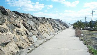
A revetment in stream restoration, river engineering or coastal engineering is a facing of impact-resistant material applied to a bank or wall in order to absorb the energy of incoming water and protect it from erosion. River or coastal revetments are usually built to preserve the existing uses of the shoreline and to protect the slope.

Geotextiles are versatile permeable fabrics that, when used in conjunction with soil, can effectively perform multiple functions, including separation, filtration, reinforcement, protection, and drainage. Typically crafted from polypropylene or polyester, geotextile fabrics are available in two primary forms: woven, which resembles traditional mail bag sacking, and nonwoven, which resembles felt.

Coastal management is defence against flooding and erosion, and techniques that stop erosion to claim lands. Protection against rising sea levels in the 21st century is crucial, as sea level rise accelerates due to climate change. Changes in sea level damage beaches and coastal systems are expected to rise at an increasing rate, causing coastal sediments to be disturbed by tidal energy.
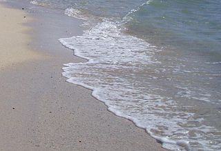
Swash, or forewash in geography, is a turbulent layer of water that washes up on the beach after an incoming wave has broken. The swash action can move beach materials up and down the beach, which results in the cross-shore sediment exchange. The time-scale of swash motion varies from seconds to minutes depending on the type of beach. Greater swash generally occurs on flatter beaches. The swash motion plays the primary role in the formation of morphological features and their changes in the swash zone. The swash action also plays an important role as one of the instantaneous processes in wider coastal morphodynamics.
Hard engineering involves the construction of hydraulic structures to protect coasts from erosion. Such structures include seawalls, gabions, breakwaters, groynes and tetrapods.
Regarding the civil engineering of shorelines, soft engineering is a shoreline management practice that uses sustainable ecological principles to restore shoreline stabilization and protect riparian habitats. Soft Shoreline Engineering (SSE) uses the strategic placement of organic materials such as vegetation, stones, sand, debris, and other structural materials to reduce erosion, enhance shoreline aesthetic, soften the land-water interface, and lower costs of ecological restoration.
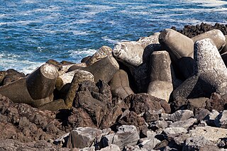
A tetrapod is a form of wave-dissipating concrete block used to prevent erosion caused by weather and longshore drift, primarily to enforce coastal structures such as seawalls and breakwaters. Tetrapods are made of concrete, and use a tetrahedral shape to dissipate the force of incoming waves by allowing water to flow around rather than against them, and to reduce displacement by interlocking.

Cuspate forelands, also known as cuspate barriers or nesses in Britain, are geographical features found on coastlines and lakeshores that are created primarily by longshore drift. Formed by accretion and progradation of sand and shingle, they extend outwards from the shoreline in a triangular shape.
Beach evolution occurs at the shoreline where sea, lake or river water is eroding the land. Beaches exist where sand accumulated from centuries-old, recurrent processes that erode rocky and sedimentary material into sand deposits. River deltas deposit silt from upriver, accreting at the river's outlet to extend lake or ocean shorelines. Catastrophic events such as tsunamis, hurricanes, and storm surges accelerate beach erosion.

Sand dune stabilization is a coastal management practice designed to prevent erosion of sand dunes. Sand dunes are common features of shoreline and desert environments. Dunes provide habitat for highly specialized plants and animals, including rare and endangered species. They can protect beaches from erosion and recruit sand to eroded beaches. Dunes are threatened by human activity, both intentional and unintentional. Countries such as the United States, Australia, Canada, New Zealand, the United Kingdom, and Netherlands, operate significant dune protection programs.

Coastal engineering is a branch of civil engineering concerned with the specific demands posed by constructing at or near the coast, as well as the development of the coast itself.
The environmental issues on Maury Island are linked to broader Puget Sound environmental issues, which include concerns regarding declining salmon and forage fish populations, degrading critical marine and shoreline habitats, and threatened species such as the Orca.
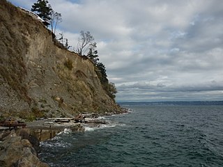
A Feeder bluff is a coastal cliff or headland that, through erosion and weathering, provides sediment to down-current beaches as a result of littoral drift. First discussed at Western Washington University, the term feeder bluff is primarily used to describe eroding bluffs in the Puget Sound region of the United States.

A Living shoreline is a relatively new approach for addressing shoreline erosion and protecting marsh areas. Unlike traditional structures such as bulkheads or seawalls that worsen erosion, living shorelines incorporate as many natural elements as possible which create more effective buffers in absorbing wave energy and protecting against shoreline erosion. The process of creating a living shoreline is referred to as soft engineering, which utilizes techniques that incorporate ecological principles in shoreline stabilization. The natural materials used in the construction of living shorelines create and maintain valuable habitats. Structural and organic materials commonly used in the construction of living shorelines include sand, wetland plants, sand fill, oyster reefs, submerged aquatic vegetation, stones and coir fiber logs.
The Sea Bright–Monmouth Beach Seawall is a seawall located along the Jersey Shore in the Monmouth County, New Jersey towns of Sea Bright and Monmouth Beach. It roughly runs north-south direction along 4.7 miles (7.6 km) of the barrier spit of land along the lower Sandy Hook peninsula between the Atlantic Ocean and the Shrewsbury River estuary. The use of seawalls, groins, jetties, bulkheads, revetment, and beach nourishment since the late 1800s has made the stretch of coast one of the most heavily engineered sections of ocean shorefront in the world.

Dynamic revetments, also known as "cobble berms" or "dynamic cobble berm revetments", use gravel or cobble-sized rocks to mimic a natural cobble storm beach for the purpose of reducing wave energy and stopping or slowing coastal erosion. Unlike seawalls, dynamic revetment is designed to allow wave action to rearrange the stones into an equilibrium profile, disrupting wave action and dissipating wave energy as the cobbles move. This can reduce the wave reflection which often contributes to beach scouring.


