Hurricane Kate (1985)

Last updated

Map key
  Tropical depression (≤38 mph, ≤62 km/h)
  Tropical storm (39–73 mph, 63–118 km/h)
  Category 1 (74–95 mph, 119–153 km/h)
  Category 2 (96–110 mph, 154–177 km/h)
  Category 3 (111–129 mph, 178–208 km/h)
  Category 4 (130–156 mph, 209–251 km/h)
  Category 5 (≥157 mph, ≥252 km/h)
  Unknown
Storm type
Disc Plain black.svg Tropical cyclone
Solid black.svg Subtropical cyclone
ArrowUp.svg Extratropical cyclone, remnant low, tropical disturbance, or monsoon depression

Before the formation of Hurricane Kate, a ridge was located across the southeastern United States for much of the autumn of 1985; concurrently, a major trough persisted across the western portion of the country. As a result, weather conditions across the Gulf of Mexico and western Atlantic Ocean in November were more typical of the pattern in late September, including sea surface temperatures of 81 °F (27 °C). On November 13, a weak tropical wave [nb 3] began interacting with a trough to the northeast of the Lesser Antilles. It gradually organized due to the favorable conditions, and on November 15, a Hurricane Hunters flight into the area indicated the development of a tropical cyclone. As gale-force winds were already present, the system was immediately declared Tropical Storm Kate, about 240 miles (385 km) northeast of San Juan, Puerto Rico. [3]

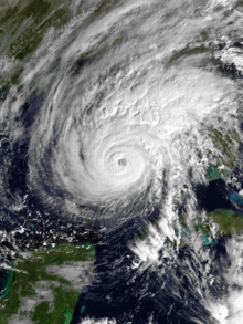
With a ridge to its north, Kate tracked westward after developing, and an upper-level low developed to the southwest of the storm. The combination of the two provided favorable outflow, allowing Kate to quickly intensify. On November 16, the storm attained hurricane status while moving through the southeastern Bahamas. [3] After continued strengthening, Kate made landfall at 0600 UTC on November 19 over north-central Cuba with a well-defined eye. [4] When it moved ashore, Kate had a pressure of 967 mbar (28.6 inHg) and winds of about 110 mph (180 km/h). [4] [5] The hurricane maintained its well-defined eye while moving across northern Cuba, and about 12 hours after making landfall, it emerged into the southeastern Gulf of Mexico just east of Havana. Over the next 24 hours, Kate re-intensified off the southwest coast of Florida as it passed about 85 mi (135 km) southwest of Key West. On November 20, the Hurricane Hunters observed winds as strong as 125 mph (200 km/h), and a buoy recorded a gust of 136 mph (219 km/h); [4] this was the highest recorded wind gust from a buoy in the Gulf of Mexico until Hurricane Lili in 2002. [6] Based on these observations, it was estimated that Kate attained peak winds of about 120 mph (190 km/h) around 1200 UTC on November 20. [5]

Hurricane Kate maintained peak intensity for about 18 hours. [5] On November 21, a cold front moving through the Mississippi Valley deflected the hurricane to the north and northeast. [7] The combination of cooler waters and wind shear from the front weakened Kate to an intensity of 100 mph (160 km/h) by the time the hurricane struck Crooked Island near Mexico Beach, Florida late on November 21. [7] [8] After landfall, Kate continued to the northeast, crossing into Georgia and weakened into a tropical storm. Kate emerged from North Carolina into the Atlantic Ocean late on November 22. Encountering even colder waters and continued shear, the storm weakened further while turning to the east-southeast. On November 23, Kate transitioned into an extratropical cyclone to the west of Bermuda, [7] terminating at 1800 UTC that day. [5]

Until 2011, Kate's was considered the second-latest hurricane landfall in the United States, behind only a cyclone in 1925 that struck on December 1; however, a systematic reanalysis indicated that the 1925 system was only a tropical storm. In turn, Kate took the record. [9] With Kate's landfall, the 1985 season had six hurricanes that struck the United States, only one short of the record seven in 1886. [10]

Preparations

By November 18, a hurricane warning was in effect for the southeast and central Bahamas and the Turks and Caicos Islands. [11] Flood warnings were issued for northern Puerto Rico and the Dominican Republic. [12] In preparation for the hurricane's arrival, officials forced 360,000 people to evacuate in north-central Cuba. [8]

While Kate was moving through the Bahamas, the National Hurricane Center (NHC) issued a hurricane warning from Jupiter to Fort Myers, Florida, including the Florida Keys. [13] Then-Governor of Florida Bob Graham declared a state of emergency for six counties in South Florida. However, it was reversed following the relatively minor effects in the area. Officials recommended evacuation of the Florida Keys, leading to heavy traffic on the Overseas Highway and prompting the Red Cross to open 12 shelters. [14] Three shelters were opened in Key West, but only 500 individuals utilized them during the storm. Most residents chose to endure the storm in their homes. [15] In Fort Lauderdale, schools were closed, and residents of mobile homes were required to leave. [14]

Shortly after the storm reached its peak intensity on November 20, the NHC issued a hurricane watch from Grand Isle, Louisiana, to Cedar Key, Florida. Later that day, a portion of the watch area was upgraded to a warning from Bay St. Louis, Mississippi to St. Marks, Florida. [13] About 20,000 employees on oil platforms in the Gulf of Mexico were evacuated, many by helicopter. [15] The USS Lexington left port from Naval Air Station Pensacola to ride out the storm in open waters, and aircraft in the region were flown inland. [16] About 100,000 people along the Florida Panhandle were told to leave their houses after Governor Bob Graham issued evacuation orders in 13 counties. [17] About 2,000 people stayed in 34 shelters in Panama City. Roads in the region suffered traffic jams from the large volume of evacuees. [18] Portions of the Florida Gulf Coast had been threatened by Hurricane Elena earlier in the season, and some evacuees of that storm intended not to leave during Kate due to the poor shelter conditions that they had experienced. [19] Governor Graham activated 300 members of the Florida National Guard to prevent looting and to assist in evacuations. One person died from a stress-induced heart attack in Chipley after evacuating. Outside of Florida, about 2,200 people fled Grand Isle, Louisiana. [18]

After Kate moved ashore, the NHC issued gale warnings along the East Coast of the United States from St. Augustine, Florida to Chincoteague, Virginia. [20]

Impact

Caribbean and Turks and Caicos Islands

Kate approaching Cuba on November 18 Kate 1985-11-18 1800Z.png.jpg
Kate approaching Cuba on November 18

Early in its duration, Hurricane Kate sank one boat near Puerto Rico and disabled three others. The crew of five on the sunken boat were rescued after 17 hours. Several homes in northern Puerto Rico were damaged, forcing hundreds to evacuate. [21] Flooding was also reported in the Dominican Republic, including around the capital Santo Domingo. [14]

Heavy rainfall and winds up to 60 mph (97 km/h) were reported in the Turks and Caicos Islands. [11] In Jamaica, heavy precipitation caused mudslides, which in turn blocked 23 major and minor roads and destroyed many bridges, culverts, and drains. Flooding in general caused severe damage to agriculture, especially in Clarendon, Manchester, Saint Ann, Saint Elizabeth, and Trelawny Parishes. Seven fatalities were reported, while the cost to repair damage was approximately $3 million (1985 USD). [22]

As Kate moved across northern Cuba, it produced strong winds that peaked at 75 mph (120 km/h) in Sagua La Grande. Wind gusts peaked at 104 mph (167 km/h) in Varadero, and winds in the capital of Havana reached 70 mph (110 km/h). [4] In Havana, high winds caused power outages and destroyed buildings. [8] Waves of 9 feet (2.7 m) affected the city's waterfront. [23] Outside of Havana, the hurricane damaged sugar mills and much of the sugar cane crop; [8] throughout the island, the winds destroyed 3,653  miles2 (9461  km2) of sugar cane and 34,000 tonnes (37,000 tons) of sugar. The storm also destroyed 141,000 tonnes (139,000 long tons; 155,000 short tons) of bananas and 87,078 tonnes (85,703 long tons; 95,987 short tons) of other fruits and vegetables. Across the island, Kate damaged 88,207 houses and destroyed 4,382 others, affecting 476,891 people. Many public buildings, including schools, were damaged. [24] Throughout the country, Kate killed 10 people and injured about 50 people. [8] Damage was estimated at $400 million, which was the highest total from all landfalling hurricanes from 1903 to 1998, unadjusted for inflation. [25]

Florida

Damage after Hurricane Kate in Tallahassee Hurricane Kate damaged cars Tallahassee, Florida.jpg
Damage after Hurricane Kate in Tallahassee

As Kate passed to the southwest of Key West, the storm produced winds of 47 mph (76 km/h) there, with unofficial wind gusts of 104 mph (167 km/h). [4] Rainfall totals in southwest Florida were generally around 1 in (25 mm), [26] although Key West reported 2.08 in (53 mm) of precipitation. High winds downed trees and power lines, [27] leaving areas between Key West and Big Pine Key without power. Electrical outages contributed to a mobile home being destroyed by fire, [8] and one person died through electrocution. [27] Above-normal tides caused minor flooding and erosion along the Florida Keys. [8] Two people died after their boat capsized in the lower Keys. [27]

Kate was the first hurricane to make landfall in the Florida Panhandle since Hurricane Eloise in 1975. [8] In the region, the hurricane dropped heavy rainfall along its path, peaking at 8.32 in (211 mm) in Panama City. [26] While moving ashore, Kate produced an 11 feet (3.4 m) storm surge at Cape San Blas, [7] causing beach and dune erosion in Gulf County. Storm surge flooding left 150 houses uninhabitable in Wakulla County. [28] The hurricane damaged a bridge to St. George Island that had been rebuilt after Hurricane Elena, and large portions of U.S. Routes 90 and 98 were washed out or damaged. [29] Just two months after Elena ravaged the Apalachicola Bay shellfish harvesting industry, Hurricane Kate destroyed remaining oyster beds, leaving many oystermen in the area without jobs. [30]

Strong winds buffeted the Florida Panhandle, accompanied by one tornado and several funnel clouds. [8] In Panama City, wind gusts reached 78 mph (126 km/h), damaging two houses, a motel, and a fishing pier. [28] The winds were strong enough to remove the roof of a two-story federal building. [31] Sustained winds blew 74 mph (119 km/h) at Cape San Blas, with gusts up to 108 mph (174 km/h). [28] Across the area, Kate severely damaged 242 buildings, mostly in Franklin County, where the storm ranked as the most devastating of the late 20th century. The storm compromised about 5.4 mi (8.7 km) of roads in the county, [28] and throughout the region many roads were washed out. The intense winds brought down numerous trees, some of them onto adjacent structures. One fallen tree struck a car, killing one person and injuring another. The winds also downed power poles and lines. [27] About 90 percent of Florida's capital Tallahassee, or about 80,000 people, lost power, and along the coast from Panama City to Apalachicola, the storm left about 30,000 homes and businesses without electricity. [32] Overall, the hurricane destroyed 325 homes along the panhandle, [33] and about 500 buildings were severely damaged. [34]

Elsewhere

Rainfall map of Kate in the United States Kate 1985 rainfall.gif
Rainfall map of Kate in the United States

Light rainfall of around 1 in (25 mm) from the hurricane extended into southeastern Alabama. [26] Rainfall was much heavier in Georgia, peaking at 7.73 in (196 mm) in Bainbridge. [35] Portions of southwestern Georgia experienced heavy damage from flash flooding and winds, and several secondary roads were washed out. Gusts of 80 mph (130 km/h) downed thousands of trees, and one fallen tree killed a man west of Thomasville. The cotton, soybean, and pecan crops suffered heavy losses, estimated at $50 million. Property and utility damage was also assessed at $50 million, and damage from flash flooding was estimated at $1 million. [27] There were scattered power outages in southern Georgia, affecting fewer than 3,000 customers by Georgia Power Company's estimation. [32] While moving across southeastern Georgia, Kate produced a 62 mph (100 km/h) wind gust in Savannah. The city also reported 1.73 in (44 mm) of rainfall. [36]

Farther northeast, Charleston, South Carolina reported a wind gust of 50 mph (80 km/h). [36] The highest rainfall total in the state was 6.56 in (167 mm) in Hampton. [35] The rains caused flash flooding that washed out secondary roads and a bridge. The storm knocked tree limbs onto power lines, leaving about 48,000 people without power. In Beaufort, trees fell onto four cars and a mobile home, and high waves sank a boat. [27] In Wilmington, North Carolina, the storm dropped 1.99 in (51 mm) of precipitation. Rains across the state caused generally minor flooding, although several cars were swept off roadways. Rising floodwaters prompted the evacuation of a nursing home in Kannapolis. [27] Rainfall extended northward into Virginia. [26] Damage throughout the United States was estimated at $300 million. [37]

As an extratropical cyclone, Kate moved north of Bermuda and produced wind gusts of 26 mph (42 km/h) on the island. [7]

Aftermath

In the month after Hurricane Kate struck the island, the government of Cuba issued a request to the United Nations (UN) World Food Council for international assistance. In response, various UN member nations collectively provided $60,000 for pesticides; $250,000 for herbicides, fungicides, and potato seeds; and $1.381 million in cooking oils and beans to fulfill the dietary needs of over 475,000 people for 60 days. The Soviet Union also donated about $15 million worth of rice and wheat flour. [24]

Hurricane Kate delayed a runoff mayoral election in Key West by two weeks. [38] Shortly after the storm, the police departments of both Leon and Jackson Counties ordered a nightly curfew. Two disaster relief centers were opened in Franklin County, one in Apalachicola and the other in Eastpoint. [39] On December 3, 1985, President of the United States Ronald Reagan declared seven Florida counties as disaster areas, making them eligible to receive federal aid. [40]

Due to the widespread power outages along the Florida Panhandle, electrical companies enlisted extra workers to repair downed lines. [41] Officials had put a curfew in place for Tallahassee due to power outages created by the hurricane, and the curfew was lifted on November 24 after power was gradually restored and roads were cleared of debris. [42] Police officers in the city arrested 20 people for violating curfew or creating unrest. [41]

Some sections of coastline already suffering from severe erosion lost additional swaths of beach to a 10-foot (3 m) storm surge and strong waves. Many fishermen before and after the storm encountered diminished fish catches after the hurricane. [29]

See also

Notes

  1. A major hurricane is a storm that ranks as Category 3 or higher on the Saffir-Simpson hurricane wind scale. [1]
  2. All damage totals are in 1985 United States dollars.
  3. A tropical wave is an inverted trough of low pressure that moves along the trade winds. [1]

Related Research Articles

<span class="mw-page-title-main">Hurricane Opal</span> Category 4 Atlantic hurricane in 1995

Hurricane Opal was a large and powerful Category 4 hurricane that caused severe and extensive damage along the northern Gulf Coast of the United States in October 1995. The fifteenth named storm, ninth hurricane and strongest tropical cyclone of the unusually active 1995 Atlantic hurricane season, Opal developed from the interaction of a tropical wave and a low-pressure area near the Yucatán Peninsula on September 27 as Tropical Depression Seventeen. The depression crossed the Yucatán Peninsula and intensified into a tropical storm on September 30. Opal intensified into a hurricane on October 2 after entering the Gulf of Mexico. The cyclone turned northeastward and strengthened significantly. By October 4, Opal was an intense 150 mph (240 km/h), Category 4 hurricane. With a minimum pressure of 916 mbar (hPa), Hurricane Opal was the most intense category 4 Atlantic hurricane on record. However, the cyclone abruptly weakened to a low-end Category 3 hurricane prior to making landfall on the Florida Panhandle near Pensacola later that day. The storm quickly unraveled as it moved inland and became extratropical on October 5. The remnants of Opal moved northward and dissipated over Ontario the following day.

<span class="mw-page-title-main">Hurricane Betsy</span> Category 4 Atlantic hurricane in 1965

Hurricane Betsy was an intense, deadly and destructive tropical cyclone that brought widespread damage to areas of Florida and the central United States Gulf Coast in September 1965. The storm's erratic nature, coupled with its intensity and minimized preparation time contributed to making Betsy the first tropical cyclone in the Atlantic basin to accrue at least $1 billion in damage. While the storm primarily affected areas of southern Florida and Louisiana, lesser effects were felt in the Bahamas and as far inland in the United States as the Ohio River Valley. Betsy began as a tropical depression north of French Guiana on August 27, and strengthened as it moved in a general northwesterly direction. After executing a slight anticyclonic loop north of the Bahamas, Betsy proceeded to move through areas of south Florida on September 8, causing extensive crop damage. After emerging into the Gulf of Mexico, the cyclone strengthened and reached its peak intensity equivalent to that of a Category 4 hurricane on September 10 before making its final landfall near Grand Isle, Louisiana, shortly thereafter. Once inland, Betsy was slow to weaken, and persisted for two more days before degenerating into an extratropical storm; these remnants lasted until September 13.

<span class="mw-page-title-main">1985 Atlantic hurricane season</span> Hurricane season in the North Atlantic Ocean

The 1985 Atlantic hurricane season had six United States landfalling hurricanes, tied with 1886 and 2020 for the highest number on record. The season officially began on June 1 and lasted until November 30. It was an average season, with 11 named storms developing. This was partially attributed to a La Niña – a meteorological phenomenon that produces favorable conditions across the Atlantic basin, such as lower wind shear and higher sea surface temperatures. The first storm, Ana, developed on July 15 near Bermuda and caused minor effects in Canada while transitioning into an extratropical cyclone. Three other tropical cyclones – Claudette, Henri, and Isabel – did not significantly affect land. Claudette developed offshore of the Southeastern United States and brushed Bermuda and the Azores. Henri and Isabel were dissipating as they approached land. However, the precursor of the latter caused a severe flood in Puerto Rico that killed 180 people. Additionally, Tropical Storm Fabian and three tropical depressions did not have any known impact on land.

<span class="mw-page-title-main">Hurricane Gloria</span> Category 4 Atlantic hurricane in 1985

Hurricane Gloria was a powerful hurricane that caused significant damage along the east coast of the United States and in Atlantic Canada during the 1985 Atlantic hurricane season. It was the first significant tropical cyclone to strike the northeastern United States since Hurricane Agnes in 1972 and the first major storm to affect New York City and Long Island directly since Hurricane Donna in 1960. Gloria was a Cape Verde hurricane originating from a tropical wave on September 16 in the eastern Atlantic Ocean. After remaining a weak tropical cyclone for several days, Gloria intensified into a hurricane on September 22 north of the Lesser Antilles. During that time, the storm had moved generally westward, although it turned to the northwest due to a weakening of the ridge. Gloria quickly intensified on September 24, and the next day reached peak winds of 145 mph (233 km/h). The hurricane weakened before striking the Outer Banks of North Carolina on September 27. Later that day, Gloria made two subsequent landfalls on Long Island and across the coastline of western Connecticut, before becoming extratropical on September 28 over New England. The remnants moved through Atlantic Canada and went on to impact Western Europe, eventually dissipating on October 4.

<span class="mw-page-title-main">Hurricane Hilda</span> Category 4 Atlantic hurricane in 1964

Hurricane Hilda was an intense tropical cyclone that ravaged areas of the United States Gulf Coast, particularly Louisiana. In addition to its damage inland, the hurricane greatly disrupted offshore oil production, and at its time was the costliest tropical cyclone for Louisiana's offshore oil production. Due in part to flights made by the National Hurricane Research Laboratory, Hilda became one of the most well-documented storms meteorologically in the Atlantic. Lasting for seven days as a tropical cyclone, Hilda caused US$126 million in damage and 38 deaths. It was the tenth named storm, sixth hurricane, and the fourth major hurricane of the 1964 Atlantic hurricane season.

<span class="mw-page-title-main">Hurricane Dennis</span> Category 4 Atlantic hurricane in 2005

Hurricane Dennis was an early-forming major hurricane in the Caribbean and Gulf of Mexico during the record-breaking 2005 Atlantic hurricane season. Dennis was the fourth named storm, second hurricane, and first major hurricane of the season. Forming in July, the hurricane became the strongest Atlantic hurricane ever to form before August at the time, a title it held for only six days before being surpassed by Hurricane Emily.

<span class="mw-page-title-main">Hurricane Juan (1985)</span> Category 1 Atlantic hurricane in 1985

Hurricane Juan was a large and erratic tropical cyclone that looped twice near the Louisiana coast, causing widespread flooding. It was the tenth named storm of the 1985 Atlantic hurricane season, forming in the central Gulf of Mexico in late October. Juan moved northward after its formation, and was subtropical in nature with its large size. On October 27, the storm became a hurricane, reaching maximum sustained winds of 85 mph (140 km/h). Due to the influence of an upper-level low, Juan looped just off southern Louisiana before making landfall near Morgan City on October 29. Weakening to tropical storm status over land, Juan turned back to the southeast over open waters, crossing the Mississippi River Delta. After turning to the northeast, the storm made its final landfall just west of Pensacola, Florida, late on October 31. Juan continued quickly to the north and was absorbed by an approaching cold front, although its moisture contributed to a deadly flood event in the Mid-Atlantic states.

<span class="mw-page-title-main">Hurricane Alma (1966)</span> Category 3 Atlantic hurricane in 1966

Hurricane Alma was a rare June major hurricane in the 1966 Atlantic hurricane season. It was the earliest Atlantic hurricane in the calendar year in fifteen years, as well as the earliest continental U.S. hurricane strike since 1825. Alma developed on June 4 over Central America, and while moving through Honduras, it dropped heavy rainfall that killed at least 75 people in the city of San Rafael. Offshore northern Honduras, the system produced heavy rainfall in Swan Island. Alma moved northeastward and intensified into a hurricane on June 6. It crossed western Cuba, causing heavy crop damage and water shortages. Alma destroyed over 1,000 houses, and damage was estimated around $200 million (1966 USD). The storm killed 12 people in the country.

<span class="mw-page-title-main">Hurricane Erin (1995)</span> Category 2 Atlantic hurricane in 1995

Hurricane Erin was the first hurricane to strike the contiguous United States since Hurricane Andrew in 1992. The fifth tropical cyclone, fifth named storm, and second hurricane of the unusually active 1995 Atlantic hurricane season, Erin developed from a tropical wave near the southeastern Bahamas on July 31. Moving northwestward, the cyclone intensified into a Category 1 hurricane on the Saffir–Simpson scale near Rum Cay about 24 hours later. After a brief jog to the north-northwest on August 1, Erin began moving to the west-northwest. The cyclone then moved over the northwestern Bahamas, including the Abaco Islands and Grand Bahama. Early on August 2, Erin made landfall near Vero Beach, Florida, with winds of 85 mph (137 km/h). The hurricane weakened while crossing the Florida peninsula and fell to tropical storm intensity before emerging into the Gulf of Mexico later that day.

<span class="mw-page-title-main">Tropical Storm Arlene (2005)</span> Atlantic tropical storm in 2005

Tropical Storm Arlene was an unusually large and early-forming tropical storm, being the first of twenty-eight different storms during the 2005 Atlantic hurricane season, which would become the second most active season on record. Tropical Storm Arlene formed near Honduras on June 8 and moved northwards. It crossed western Cuba on June 10 and strengthened to just under hurricane strength before making its final landfall on the Florida Panhandle the next day. The storm weakened as it continued to move north over the United States, becoming extratropical on June 13. Arlene was responsible for two deaths and minor damage.

<span class="mw-page-title-main">Hurricane Gordon (2000)</span> Category 1 Atlantic hurricane in 2000

Hurricane Gordon caused minor damage in the Eastern United States. The seventh named storm and fourth hurricane of the 2000 Atlantic hurricane season, Gordon developed in the extreme western Caribbean Sea from a tropical wave on September 14. Shortly thereafter, the depression moved inland over the Yucatán Peninsula and later emerged into the Gulf of Mexico on September 15. The depression began to quickly organize, and by early on September 16, it was upgraded to Tropical Storm Gordon. After becoming a tropical storm, Gordon continued to intensify and was reclassified as a hurricane about 24 hours later; eventually, the storm peaked as an 80 mph (130 km/h) Category 1 hurricane. However, southwesterly upper-level winds caused Gordon to weaken as it approached land, and it was downgraded to a tropical storm by late on September 17. At 0300 UTC on September 18, Gordon made landfall near Cedar Key, Florida as a strong tropical storm. After moving inland, Gordon rapidly weakened and had deteriorated to tropical depression status by nine hours later. Later that day, Gordon merged with a frontal boundary while centered over Georgia.

<span class="mw-page-title-main">Hurricane Chantal (1989)</span> Category 1 Atlantic hurricane in 1989

Hurricane Chantal was one of three tropical cyclones to make landfall in Texas during the 1989 Atlantic hurricane season. The third named storm and the first hurricane of the season, Chantal slowly developed on July 30 in the southern Gulf of Mexico from a tropical disturbance that was previously within Intertropical Convergence Zone (ITCZ) while near Trinidad and Tobago. While heading north-northwestward, the depression steadily intensified and was upgraded to Tropical Storm Chantal on the following day. Thereafter, Chantal quickly strengthen and became a hurricane on August 1. After intensifying slightly further, Chantal made landfall near High Island, Texas later that day. The storm quickly weakened upon moving inland and fell to tropical storm intensity a few hours after landfall. Early on August 2, Chantal weakened to a tropical depression and dissipated over Oklahoma by August 4.

<span class="mw-page-title-main">Tropical Storm Barry (2001)</span> Atlantic tropical cyclone

Tropical Storm Barry was a strong tropical storm that made landfall on the Florida Panhandle during August 2001. The third tropical cyclone and second named storm of the 2001 Atlantic hurricane season, Barry developed from a tropical wave that moved off the coast of Africa on July 24. The wave entered the Caribbean on July 29 and spawned a low-pressure area, which organized into Tropical Storm Barry on August 3. After fluctuations in intensity and track, the storm attained peak winds of 70 mph (110 km/h) over the Gulf of Mexico. Barry headed northward and moved ashore along the Gulf Coast before degenerating into a remnant low on August 7. On the next day, Barry's remnants dissipated over Missouri.

<span class="mw-page-title-main">Tropical Storm Helene (2000)</span> Atlantic tropical storm in 2000

Tropical Storm Helene was a long-lived tropical cyclone that oscillated for ten days between a tropical wave and a 70 mph (110 km/h) tropical storm. It was the twelfth tropical cyclone and eighth tropical storm of the 2000 Atlantic hurricane season, forming on September 15 east of the Windward Islands. After degenerating into a tropical wave, the system produced flooding and mudslides in Puerto Rico. It reformed into a tropical depression on September 19 south of Cuba, and crossed the western portion of the island the next day while on the verge of dissipation. However, it intensified into a tropical storm in the Gulf of Mexico, reaching its peak intensity while approaching the northern Gulf Coast.

<span class="mw-page-title-main">Effects of Hurricane Katrina in Florida</span>

The effects of Hurricane Katrina in Florida were in both the southern portion of the state and in the panhandle. After developing on August 23, Katrina made landfall near the border of Broward and Miami-Dade counties with 80 mph (130 km/h) winds on August 25. While it was crossing the state, the hurricane's convection was asymmetrical, primarily located to the south and east of the center. As a result, high rainfall totals occurred in the Miami area, peaking at 16.43 in (417 mm) in Perrine. The rains caused flooding, and the combination of rains and winds downed trees and power lines, leaving 1.45 million people without power. Damage in South Florida was estimated at $523 million (2005 USD), mostly as a result of crop damage. Further south, the hurricane spawned a tornado in the Florida Keys. In the island chain, Katrina caused heavy rainfall and gusty winds.

<span class="mw-page-title-main">Effects of Hurricane Georges in Florida</span>

The effects of Hurricane Georges in Florida lasted for more than a week in late September and early October in 1998. After developing from a tropical wave to the south of Cape Verde on September 15, Georges moved steadily west-northwestward and peaked as a strong Category 4 hurricane on the Saffir–Simpson scale on September 20. After weakening slightly to a Category 3, the cyclone proceeded to strike Antigua, Saint Kitts and Nevis, Puerto Rico, Dominican Republic, and Cuba. Georges emerged into the Straits of Florida as a Category 1, but re-strengthened slightly to a Category 2 before making landfall in Key West, Florida, on September 25. The hurricane continued northwestward into the Gulf of Mexico and struck near Biloxi, Mississippi, on September 28. After moving inland, Georges turned eastward and crossing into the Florida Panhandle on the next day. By October 1, the system dissipated near the northeast Florida–southeast Georgia coast.

References

  1. 1 2 Glossary of NHC Terms (Report). National Hurricane Center. March 30, 2012. Retrieved May 1, 2012.
  2. Robert A. Case (December 10, 1985). Hurricane Kate Preliminary Report (GIF) (Report). National Hurricane Center. p. 11. Retrieved November 17, 2016.
  3. 1 2 Robert A. Case (December 10, 1985). Hurricane Kate Preliminary Report (GIF) (Report). National Hurricane Center. p. 1. Retrieved May 9, 2012.
  4. 1 2 3 4 5 Robert A. Case (December 10, 1985). Hurricane Kate Preliminary Report (GIF) (Report). National Hurricane Center. p. 2. Retrieved May 13, 2012.
  5. 1 2 3 4 Atlantic hurricane best track (HURDAT version 2). Hurricane Research Division (Report). National Oceanic and Atmospheric Administration. July 6, 2016. Retrieved October 28, 2016.
  6. Upper Texas Coast Tropical Cyclones in the 2000s (Report). Houston/Galveston, Texas National Weather Service. February 23, 2012. Archived from the original on March 4, 2016. Retrieved October 28, 2016.{{cite report}}: CS1 maint: bot: original URL status unknown (link)
  7. 1 2 3 4 5 Robert A. Case (December 10, 1985). Hurricane Kate Preliminary Report (GIF) (Report). National Hurricane Center. p. 3. Retrieved May 13, 2012.
  8. 1 2 3 4 5 6 7 8 9 Ralph Clark (September 1986). Hurricane Kate November 15–23, 1985 (PDF) (Report). Florida Department of Natural Resources. Archived from the original on September 27, 2015. Retrieved October 28, 2016.{{cite report}}: CS1 maint: bot: original URL status unknown (link)
  9. "New Record Holder for Latest Hurricane in the Season to Strike U.S. Coastline" (PDF). National Hurricane Center. November 18, 2011. Retrieved November 20, 2011.
  10. Eric S. Blake; Ethan J. Gibney (August 2012). The Deadliest, Costliest, and Most Intense United States Tropical Cyclones from 1851 to 2010 (and Other Frequently Requested Hurricane Facts) (PDF) (Report). National Hurricane Center. p. 17. Retrieved May 15, 2012.
  11. 1 2 "Hurricane Kate threatens Bahamas". Milwaukee Journal Sentinel . Associated Press. November 18, 1985. Archived from the original on October 5, 2018. Retrieved June 30, 2012.
  12. "Hurricane strengthens over Atlantic". The Deseret News. Salt Lake City, Utah. United Press International. November 17, 1985. Retrieved August 14, 2013.
  13. 1 2 Robert A. Case (December 10, 1985). Table 1. Watches and Warnings Issued by the National Hurricane Center (GIF) (Report). National Hurricane Center. Retrieved May 15, 2012.
  14. 1 2 3 "Hurricane Kate Threatens to Attack and Flood Florida Keys". Lodi News-Sentinel. Lodi, California. United Press International. November 18, 1985. pp. 1, 10. Retrieved August 18, 2013.
  15. 1 2 "Hurricane Kate whirls into the gulf". Pittsburgh Post-Gazette . Associated Press. November 20, 1985. Retrieved June 30, 2012.
  16. Bill Kaczor (November 21, 1985). "Kate Charges Toward Panhandle". Gainesville Sun. Associated Press. Retrieved August 27, 2013.
  17. "Cooler Air Weakens 'Kate' Near Florida". The Bulletin. Bend, Oregon. United Press International. November 21, 1985. Retrieved August 21, 2013.
  18. 1 2 "Hurricane Stalks Gulf Coast; 87,000 Told to Move Inland". The Vindicator. Youngstown, Ohio. Associated Press. November 21, 1985. Retrieved August 27, 2013.
  19. Judy Garnatz (November 20, 1985). "Little Activity Seen in Storm Preparations". The Evening Independent. St. Petersburg, Florida. Retrieved August 30, 2013.
  20. Robert A. Case (December 10, 1985). Table 1. Watches and Warnings Continued (GIF) (Report). National Hurricane Center. Retrieved May 15, 2012.
  21. "Florida Braces for Hurricane". The Altus Times. Altus, Oklahoma. United Press International. November 18, 1985. Retrieved August 15, 2013.
  22. Office for the Coordination of Humanitarian Affairs (December 12, 1985). Jamaica Hurricane Kate Dec 1985 UNDRO Situation Report 1 (Report). ReliefWeb . Retrieved June 30, 2012.
  23. Janet Braustein (November 20, 1985). "Kate Spins into Gulf of Mexico". The Lewiston Journal. Lewiston-Auburn, Maine. Associated Press. Retrieved August 27, 2013.
  24. 1 2 UNDRO Situation Reports 1–4 (Report). ReliefWeb. December 19, 1985. Retrieved October 29, 2016.
  25. Roger A. Pielke Jr.; Jose Rubiera; Christopher Landsea; Mario L. Fernández; Roberta Klein (August 2003). "Hurricane Vulnerability in Latin America and The Caribbean: Normalized Damage and Loss Potentials" (PDF). National Hazards Review. National Oceanic and Atmospheric Administration: 108. Archived from the original (PDF) on November 19, 2012. Retrieved May 25, 2012.
  26. 1 2 3 4 David M. Roth (June 15, 2007). "Hurricane Kate – November 19–22, 1985". Weather Prediction Center. Retrieved May 14, 2012.
  27. 1 2 3 4 5 6 7 "Storm Data and Unusual Weather Phenomena" (PDF). Storm Data. National Climatic Data Center. 27 (11): 16–17, 20, 23. November 1985. ISSN   0039-1972. Archived from the original (PDF) on April 22, 2014. Retrieved May 15, 2012.
  28. 1 2 3 4 Clark, Ralph R.; LaGrone, James. A Comparative Analysis of Hurricane Dennis and Other Recent Hurricanes on the Coastal Communities of Northwest Florida (PDF) (Report). Florida Shore and Beach Preservation Association. Retrieved May 15, 2012.
  29. 1 2 Soneni Bryant. Kate Wreaks Havoc on Oyster Industry (PDF) (Report). Tallahassee Democrat. Archived from the original on March 26, 2006. Retrieved October 28, 2016.{{cite report}}: CS1 maint: bot: original URL status unknown (link)
  30. Robert A. Case (December 10, 1985). Hurricane Kate Preliminary Report (GIF) (Report). National Hurricane Center. p. 4. Retrieved May 15, 2012.
  31. "Hurricane Kate Tears Up Florida". The Leader-Post. Regina, Saskatchewan. AP. November 22, 1985. Retrieved December 10, 2013.
  32. 1 2 "Kate Takes Aim at the Carolinas". The Robesonian. Lumberton, North Carolina. Associated Press. November 22, 1985. Retrieved December 10, 2013.
  33. "Disaster Declaration Sought". Times Daily. Florence, Alabama. Associated Press. November 28, 1985. Retrieved December 10, 2013.
  34. "Graham Says 5 Counties May Qualify for Kate Aid". Ocala Star Banner. Ocala, Florida. Associated Press. November 26, 1985. Retrieved December 10, 2013.
  35. 1 2 Roth, David M (May 12, 2022). "Tropical Cyclone Rainfall in the Southeastern United States". Tropical Cyclone Rainfall. United States Weather Prediction Center. Retrieved January 6, 2023.PD-icon.svg This article incorporates text from this source, which is in the public domain.
  36. 1 2 Tropical Cyclone History for Southeast South Carolina and Northern Portions of Southeast Georgia (Report). Charleston, South Carolina National Weather Service. August 1, 2016. Retrieved October 28, 2016.
  37. Robert A. Case (1986). "Atlantic Hurricane Season of 1985" (PDF). Monthly Weather Review. American Meteorological Society. 114 (7): 1390. Bibcode:1986MWRv..114.1390C. doi:10.1175/1520-0493(1986)114<1390:ahso>2.0.co;2 . Retrieved December 10, 2013.
  38. "Key West Elects Banker as Mayor". The New York Times. Associated Press. December 5, 1985. Retrieved August 31, 2013.
  39. "Residents Without Power; Floods Isolate Some Cities". The Palm Beach Post. Vol. 19, no. 14. West Palm Beach, Florida. Associated Press. November 23, 1985. p. A12. Retrieved July 3, 2019 via Newspapers.com.
  40. Florida Hurricane Kate Major Disaster Declared December 3, 1985 (DR-756) (Report). Federal Emergency Management Agency. November 23, 2004. Retrieved December 11, 2013.
  41. 1 2 "Kate Dies Out; North Shivers". The Telegraph. Dubuque, Iowa. United Press International. November 24, 1985. Retrieved December 10, 2013.
  42. Mike Cassidy. City Gradually Returns to Normal (PDF) (Report). Tallahassee Democrat. Archived from the original on March 26, 2006. Retrieved December 10, 2013.{{cite report}}: CS1 maint: bot: original URL status unknown (link)
Hurricane Kate
Kate 1985-11-20 1400Z.png
Hurricane Kate near peak intensity in the Gulf of Mexico on November 20