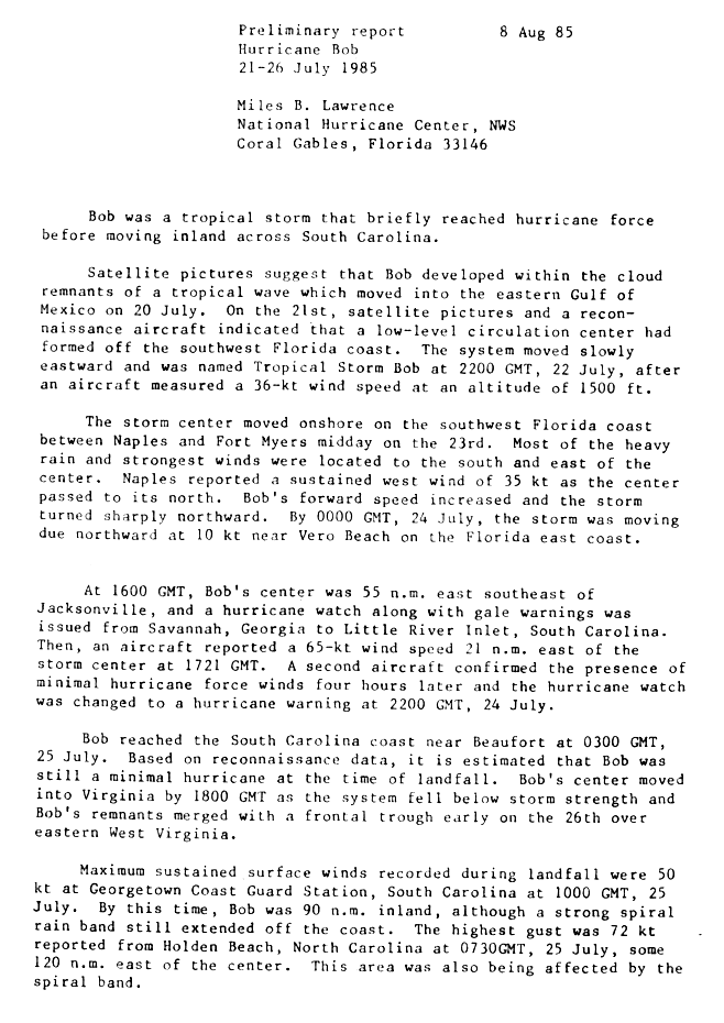
Hurricane Bob (1985)

Last updated
Map key
  Tropical depression (≤38 mph, ≤62 km/h)
  Tropical storm (39–73 mph, 63–118 km/h)
  Category 1 (74–95 mph, 119–153 km/h)
  Category 2 (96–110 mph, 154–177 km/h)
  Category 3 (111–129 mph, 178–208 km/h)
  Category 4 (130–156 mph, 209–251 km/h)
  Category 5 (≥157 mph, ≥252 km/h)
  Unknown
Storm type
Disc Plain black.svg Tropical cyclone
Solid black.svg Subtropical cyclone
ArrowUp.svg Extratropical cyclone, remnant low, tropical disturbance, or monsoon depression

The remnants of a tropical wave entered the eastern Gulf of Mexico on July 20. An area of low pressure formed and developed into a tropical depression on July 21. Under weak steering currents, the tropical depression drifted southeast, then turned northeast and later east. Based on reports from Hurricane Hunters, the system intensified into Tropical Storm Bob late on July 22. Bob failed to organize significantly as it tracked east through the Gulf, and made landfall between Naples and Fort Myers, Florida, on July 23 as a 45 mph (70 km/h) tropical storm. At the time, most of the convection was concentrated south and east of the center. [2]

While moving across Florida, Bob turned to the northeast, then to the north. It subsequently left the peninsula, entering the Atlantic Ocean near Vero Beach early on July 24. As it moved over the warm waters of the Gulf Stream, it quickly organized and intensified into a Category 1 hurricane while 70 mi (115 km) east of Jacksonville, Florida. [2] Because it was embedded within the western extension of the subtropical ridge, Bob retained higher-than-average atmospheric pressures throughout its lifespan. [3] The hurricane continued north, and made landfall near Beaufort, South Carolina, early on July 25 while maintaining winds of 75 mph (120 km/h). Bob quickly weakened over land, decaying into a tropical storm three hours after landfall. [2] [4] About 12 hours later, it degenerated into a tropical depression near the North CarolinaVirginia border. Bob's remnants turned north-northeast, and were absorbed by a frontal trough over eastern West Virginia on July 26. [2] An associated area of disturbed weather remained separate from the trough, and continued northeast through the Mid-Atlantic and New England. [5]

Preparations

When Bob was designated a tropical storm, the National Hurricane Center issued gale warnings for the Florida Keys west of Craig Key, and from Flamingo to Venice. Gale warnings were later posted for the Atlantic coast of Florida northward through St. Augustine. [6] Small craft south of St. Augustine were advised to remain in port. [7] While the storm was situated off the east-central coast of Florida, the National Hurricane Center issued a gale warning and a hurricane watch from Savannah, Georgia, to Little River, South Carolina. The hurricane watch was upgraded to a hurricane warning after Bob's intensification to Category 1 status. [2]

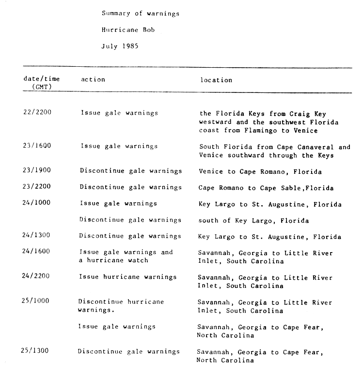
Thousands of residents evacuated coastal areas of South Carolina, many of whom stayed at inland hotels; 850 people sought protection in shelters, including 500 at an elementary school in Horry County and 240 in a shelter in the Grand Strand. In Beaufort County, city and county offices were closed early and businesses were advised to send their workers home prematurely. Officials in Chatham County, Georgia, evacuated nursing homes on Tybee Island, and encouraged others to leave due to the potential for high tides to isolate the island by cutting off U.S. Route 80. [8]

Impact

Hurricane Bob inflicted $20 million in damages [9] and caused five indirect deaths. Damage from the storm was not severe enough to justify retirement of the name "Bob", and as such it was re-used during the 1991 season. [10]

Florida

Tropical Storm Bob making landfall on Florida TS Bob (1985).JPG
Tropical Storm Bob making landfall on Florida

In southern Florida, the heaviest rainfall remained to the south and east of the storm's center; 21.5 inches (546 mm) of precipitation was recorded in Everglades City. [3] Northern parts of the state reported trace amounts to several inches of precipitation. [5] At Naples, sustained winds reached 40 mph (65 km/h), with a peak gust of 58 mph (93 km/h). [3] Rough surf and above-average tides caused moderate to severe beach erosion in portions of coastal Manatee, Sarasota, and Charlotte counties. [11] [12] Before landfall, Tropical Storm Bob spawned an F0 tornado in Brevard County that caused $2,500 in damage (1985 USD, $4,700 2006 USD) along its 1-mile (1.6 km) path. [13] [14]

Tropical Storm Bob flooded roads and downed trees in Florida. [15] Rough seas broke over sea walls in southwestern parts of the state, and the combination of high tides and heavy rain caused forced the closure of causeways to Sanibel Island and Marco Island, leaving the islands temporarily isolated. They were re-opened when the waters receded, [7] though the causeway to Sanibel Island sustained some damage. [16] Florida Power & Light Co. reported that 1,200 to 1,500 residences were without power on July 23. [7] In Palm Beach County, rainfall from the storm caused agricultural damage. [17]

Overall damage was minimal and primarily confined to minor property near the coast. The storm's rainfall was beneficial in areas that had suffered dry conditions. [7] In northeastern Florida and Georgia, beach erosion occurred along the coast. [3] Bob was one of four July tropical cyclones to affect Palm Beach County since 1878. [18]

Carolinas

Estimated rainfall totals from Hurricane Bob Bob 1985 rainfall.gif
Estimated rainfall totals from Hurricane Bob

The strongest winds from Hurricane Bob were confined to areas east of its center when it came ashore around 1 am Eastern Standard Time (EST). [19] Along the barrier islands off the coast of Charleston, windows were broken and power lines knocked down. Further inland, the lack of damage in spite of high winds was described as "almost unbelievable". [20] Georgetown, South Carolina, 105 miles (170 km) northeast of where the storm made landfall, recorded sustained winds of 58 mph (93 km/h), and a spiral rainband produced a peak wind gust of 83 mph (134 km/h) in Holden Beach. Upon moving ashore, the hurricane produced an estimated storm tide of 2.6 feet (0.79 m) in Edisto Beach. [3] Rainfall in the Carolinas was moderate; portions of coastal South Carolina received over 5 inches (127 mm) of precipitation. [5] Myrtle Beach reported a statewide peak of 7.79 inches (198 mm). [3] Hurricane-force wind gusts downed trees and power lines, leaving over 32,000 people without power, including more than 25,000 in the Charleston area. Near the coast, high winds shattered windows. [21]

Strong waves broke over sea walls in Charleston, spilling floodwaters onto coastal streets and homes. [22] Damage in the state was relatively light, and no serious injuries were reported. [21] However, a gas station in Folly Beach was torn apart by the winds, [23] and some structures along the coast sustained roof damage. [24] In the Charleston Harbor, an empty tanker was forced aground on a sandbar by the winds. [25] Throughout most areas, the storm was insignificant; a police sergeant in Summerville commented, "All we've had were some trees blown over, hardly enough to make it worth staying up so late." [26]

Much of North Carolina received over 1 inch (25.4 mm) of rain; as much as 7 inches (178 mm) fell in Beaufort County. [5] The storm caused one traffic-related fatality in the state. [27]

Mid-Atlantic and New England

In Virginia, a large band of thunderstorms associated with the hurricane brought strong winds and spawned three tornadoes. A funnel cloud formed in Albemarle County evolved into an F3 tornado after crossing into Greene County. It destroyed two houses and uprooted several trees, [28] inflicting $250,000 in damage (1985 USD, $470,000 2006 USD). [29] F0 tornadoes were also generated in Goochland County and Hanover County; [28] the two tornadoes damaged a total of ten houses. Funnel clouds were sighted throughout the Baltimore-Washington Metropolitan Area. [30]

Heavy precipitation and high winds disrupted the 1985 Boy Scouts of America National Scout Jamboree at Fort A. P. Hill near Fredericksburg, Virginia, knocking over hundreds of tents and fifty portable toilets. [31] One scout was struck by a falling gateway and several others sustained minor cuts and bruises. [32] The storm produced winds of 48 mph (77 km/h) at the Ronald Reagan Washington National Airport, and about 30,000 people near Washington, D.C., and 125,000 in Baltimore were left without power. [30] [32] Moderate winds downed a sea plane near Hains Point in the Washington Channel. [30] Rough seas capsized a few boats along the Potomac River, and rainfall from Bob's remnants forced the cancellation of a Richmond Braves game. [33] and collapsed a house under construction in Great Falls, Maryland. [30] A dam in Northeastern Virginia sustained storm-related damage. [34] Slick roads led to several traffic accidents; one person in Washington, D.C., and three in Maryland were killed. [30] High winds in the Washington, D.C., area also flipped over a pontoon-equipped Cessna 210 airplane near Hains Point, holding a five-man television crew. The crew, who worked for the television series Lime Street had been preparing to film a chase scene for the television drama. All five escaped the plane safely with the aid of the Metropolitan Police Department of the District of Columbia harbor patrol. [31]

Rainfall in the Mid-Atlantic and New England states was around 1 inch (25.4 mm), with isolated reports of over 3 inches (76 mm). [5] About 0.5 inches (13 mm) of precipitation fell in Atlantic City, New Jersey, within a period of 10 minutes. [32] In Maryland, the rainfall helped to relieve persistent dry conditions. [35]

See also

Related Research Articles

<span class="mw-page-title-main">Hurricane Agnes</span> Category 1 Atlantic hurricane in 1972

Hurricane Agnes in 1972 was the costliest hurricane to hit the United States at the time, causing an estimated $2.1 billion in damage. The hurricane's death toll was 128. The effects of Agnes were widespread, from the Caribbean to Canada, with much of the east coast of the United States affected. Damage was heaviest in Pennsylvania, where Agnes was the state's wettest tropical cyclone. Due to the significant effects, the name Agnes was retired in the spring of 1973.

<span class="mw-page-title-main">1985 Atlantic hurricane season</span> Hurricane season in the North Atlantic Ocean

The 1985 Atlantic hurricane season had six United States landfalling hurricanes, tied with 1886 and 2020 for the highest number on record. The season officially began on June 1 and lasted until November 30. It was an average season, with 11 named storms developing. This was partially attributed to a La Niña – a meteorological phenomenon that produces favorable conditions across the Atlantic basin, such as lower wind shear and higher sea surface temperatures. The first storm, Ana, developed on July 15 near Bermuda and caused minor effects in Canada while transitioning into an extratropical cyclone. Three other tropical cyclones – Claudette, Henri, and Isabel – did not significantly affect land. Claudette developed offshore of the Southeastern United States and brushed Bermuda and the Azores. Henri and Isabel were dissipating as they approached land. However, the precursor of the latter caused a severe flood in Puerto Rico that killed 180 people. Additionally, Tropical Storm Fabian and three tropical depressions did not have any known impact on land.

<span class="mw-page-title-main">Tropical Storm Bonnie (2004)</span> Atlantic tropical cyclone

Tropical Storm Bonnie was a tropical storm that made landfall on Florida in August 2004. The second storm of the 2004 Atlantic hurricane season, Bonnie developed from a tropical wave on August 3 to the east of the Lesser Antilles. After moving through the islands, its fast forward motion caused it to dissipate. However, Bonnie later regenerated into a tropical storm near the Yucatán Peninsula. Bonnie attained its peak intensity with maximum 1-minute sustained winds of 65 miles per hour (105 km/h) and a minimum central pressure of 1,001 mbar on August 11 while located over the Gulf of Mexico. Afterwards, the storm turned to the northeast and hit Florida with winds of 45 miles per hour (72 km/h). The storm accelerated to the northeast and became an extratropical cyclone to the east of New Jersey. Bonnie was the first of five tropical systems in the 2004 season to make landfall in Florida, coming ashore the day before Hurricane Charley struck. Bonnie was also the second of a record eight storms to reach tropical storm strength during the month of August.

<span class="mw-page-title-main">Hurricane Jeanne</span> Category 3 Atlantic hurricane in 2004

Hurricane Jeanne was a Category 3 hurricane that struck the Caribbean and the Eastern United States in September 2004. It was the deadliest hurricane in the Atlantic basin since Mitch in 1998. It was the tenth named storm, the seventh hurricane, and the fifth major hurricane of the season, as well as the third hurricane and fourth named storm of the season to make landfall in Florida. After wreaking havoc on Hispaniola, Jeanne struggled to reorganize, eventually strengthening and performing a complete loop over the open Atlantic. It headed westwards, strengthening into a Category 3 hurricane and passing over the islands of Great Abaco and Grand Bahama in the Bahamas on September 25. Jeanne made landfall later in the day in Florida just two miles from where Hurricane Frances had struck a mere three weeks earlier.

<span class="mw-page-title-main">Hurricane Danny (1997)</span> Category 1 Atlantic hurricane

Hurricane Danny was the only hurricane to make landfall in the United States during the 1997 Atlantic hurricane season, and the second hurricane and fourth tropical storm of the season. The system became the earliest-formed fifth tropical or subtropical storm of the Atlantic season in history when it attained tropical storm strength on July 17, and held that record until the 2005 Atlantic hurricane season when Tropical Storm Emily broke that record by several days. Like the previous four tropical or subtropical cyclones of the season, Danny had a non-tropical origin, after a trough spawned convection that entered the warm waters of the Gulf of Mexico. Danny was guided northeast through the Gulf of Mexico by two high pressure areas, a rare occurrence in the middle of July. After making landfall on the Gulf Coast, Danny tracked across the southeastern United States and ultimately affected parts of New England with rain and wind.

<span class="mw-page-title-main">Hurricane Gordon (2000)</span> Category 1 Atlantic hurricane in 2000

Hurricane Gordon caused minor damage in the Eastern United States. The seventh named storm and fourth hurricane of the 2000 Atlantic hurricane season, Gordon developed in the extreme western Caribbean Sea from a tropical wave on September 14. Shortly thereafter, the depression moved inland over the Yucatán Peninsula and later emerged into the Gulf of Mexico on September 15. The depression began to quickly organize, and by early on September 16, it was upgraded to Tropical Storm Gordon. After becoming a tropical storm, Gordon continued to intensify and was reclassified as a hurricane about 24 hours later; eventually, the storm peaked as an 80 mph (130 km/h) Category 1 hurricane. However, southwesterly upper-level winds caused Gordon to weaken as it approached land, and it was downgraded to a tropical storm by late on September 17. At 0300 UTC on September 18, Gordon made landfall near Cedar Key, Florida as a strong tropical storm. After moving inland, Gordon rapidly weakened and had deteriorated to tropical depression status by nine hours later. Later that day, Gordon merged with a frontal boundary while centered over Georgia.

<span class="mw-page-title-main">Tropical Storm Bill (2003)</span> Atlantic tropical cyclone

Tropical Storm Bill was a tropical storm that affected the Gulf Coast of the United States in the summer of 2003. The second storm of the 2003 Atlantic hurricane season, Bill developed from a tropical wave on June 29 to the north of the Yucatán Peninsula. It slowly organized as it moved northward, and reached a peak of 60 miles per hour (97 km/h) shortly before making landfall in south-central Louisiana. Bill quickly weakened over land, and as it accelerated to the northeast, moisture from the storm, combined with cold air from an approaching cold front, produced an outbreak of 34 tornadoes. Bill became extratropical on July 2, and was absorbed by the cold front later that day.

<span class="mw-page-title-main">Tropical Storm Alberto (2006)</span> Atlantic tropical cyclone

Tropical Storm Alberto was the first tropical storm of the 2006 Atlantic hurricane season. Forming on June 10 in the northwestern Caribbean, the storm moved generally to the north, reaching a maximum intensity of 70 mph (110 km/h) before weakening and moving ashore in the Big Bend area of Florida on June 13. Alberto then moved through eastern Georgia, North Carolina, and Virginia as a tropical depression before becoming extratropical on June 14.

<span class="mw-page-title-main">Tropical Storm Chris (1988)</span> Atlantic tropical storm in 1988

Tropical Storm Chris caused minor flooding in the Greater Antilles and the Eastern United States in August 1988. The seventh tropical cyclone and third named storm of the annual hurricane season, Chris developed from a tropical wave while roughly midway between Africa and the Lesser Antilles on August 21. Forming as a tropical depression, it remained weak for several days, crossing the Lesser Antilles, Hispaniola, and The Bahamas during this time. While offshore the coast of Florida on August 28, the depression intensified into Tropical Storm Chris. Thereafter, the system tracked rapidly north-northwestward and came ashore near Savannah, Georgia later that day. Once inland, Chris quickly weakened, and by early on the following day, it weakened to a tropical depression over South Carolina. Six hours later, Chris was absorbed by a cold front while over North Carolina, though the remnants of the system tracked across the Eastern United States and Atlantic Canada before dissipating on August 30.

<span class="mw-page-title-main">Hurricane Abby (1968)</span> Category 1 Atlantic hurricane in 1968

Hurricane Abby made landfall in Cuba, Florida, and North Carolina in June 1968. The first tropical cyclone, first named storm, and first hurricane on the season, Abby developed over the northwestern Caribbean Sea on June 1, as a result of the interaction between a mid-tropospheric trough and a cold front. Moving generally north-northeastward, the depression slowly strengthened while approaching the western tip of Cuba, becoming Tropical Storm Abby late on June 2. Shortly thereafter, Abby made landfall in Pinar del Río Province. The storm dropped heavy rainfall in western Cuba, with up to 12 inches (300 mm) on Isla de la Juventud. However, no flooding was reported. After reaching the southeastern Gulf of Mexico on June 3, Abby strengthened further and became a Category 1 hurricane on the modern-day Saffir–Simpson hurricane wind scale. However, early on June 4, Abby weakened to a tropical storm. Around midday on June 4, the system made landfall near Punta Gorda, Florida as a strong tropical storm.

<span class="mw-page-title-main">1982 Florida subtropical storm</span> Atlantic subtropical storm in 1982

The 1982 Florida subtropical storm, officially known as Subtropical Storm One, was the only subtropical cyclone of the exceptionally inactive 1982 Atlantic hurricane season. The storm originated from two different systems around the Gulf of Mexico and Caribbean on June 16. The systems merged into trough while a circulation began to form off the coast of Florida on June 18. The depression made landfall in Florida and strengthened into a storm over land. The storm entered the Atlantic Ocean and headed to the northeast, becoming extratropical on June 20 near Newfoundland. The storm was the only system of 1982 to affect the eastern half of the United States, and it caused three fatalities and caused $10 million in damage.

<span class="mw-page-title-main">Tropical Storm Marco (1990)</span> 1990 North Atlantic tropical storm

Tropical Storm Marco was the only tropical cyclone to make landfall on the United States during the 1990 Atlantic hurricane season. The 13th named storm of the season, Marco formed from a cold-core low pressure area along the northern coast of Cuba on October 9, and tracked northwestward through the eastern Gulf of Mexico. With most of its circulation over the western portion of Florida, Tropical Storm Marco produced 65 mph (105 km/h) winds over land. However, it weakened to a tropical depression before moving ashore near Cedar Key. The cyclone combined with a cold front and the remnants of Hurricane Klaus to produce heavy rainfall in Georgia and the Carolinas. After interacting with the nearby Hurricane Lili, Marco continued northward until being absorbed by a cold front on October 13.

<span class="mw-page-title-main">Tropical Storm Barry (2007)</span> Atlantic tropical cyclone

Tropical Storm Barry was a rapidly forming tropical cyclone that made landfall on Florida, United States, in early June 2007. The second named storm of the 2007 Atlantic hurricane season, Barry developed from a trough of low pressure in the southeastern Gulf of Mexico on June 1. It tracked rapidly northeastward, reaching peak winds of 60 mph (97 km/h) before weakening and making landfall near Tampa Bay as a tropical depression. Barry quickly lost tropical characteristics after wind shear removed much of the convection, and early on June 3, it completed the transition into an extratropical cyclone. The extratropical remnants tracked up the East Coast of the United States, and were absorbed by a larger extratropical cyclone on June 5.

<span class="mw-page-title-main">Tropical Storm Bret (1981)</span> Atlantic tropical storm in 1981

Tropical Storm Bret made a rare landfall on the Delmarva Peninsula in June 1981. The sixth tropical cyclone, third designated tropical depression, and second named storm of the season, Bret developed as a subtropical storm from a large area of frontal clouds near Bermuda on June 29. Moving westward, the subtropical storm intensified while producing deep convection, and was consequently reclassified as a tropical storm early on June 30. Around that time, Bret peaked with sustained winds of 70 mph (110 km/h). The storm then began weakening and struck near Oyster, Virginia as a minimal tropical storm early on July 1. Upon moving inland, Bret weakened to a tropical depression and subsequently accelerated prior to dissipating over northern Virginia that same day.

<span class="mw-page-title-main">Tropical Storm Andrea (2013)</span> Atlantic Tropical storm in the 2013

Tropical Storm Andrea brought flooding to Cuba, the Yucatan Peninsula, and portions of the East Coast of the United States in June 2013. The first tropical cyclone and named storm of the annual hurricane season, Andrea originated from an area of low pressure in the eastern Gulf of Mexico on June 5. Despite strong wind shear and an abundance of dry air, the storm strengthened while initially heading north-northeastward. Later on June 5, it re-curved northeastward and approached the Big Bend region of Florida. Andrea intensified and peaked as a strong tropical storm with winds at 65 mph (105 km/h) on June 6. A few hours later, the storm weakened slightly and made landfall near Steinhatchee, Florida later that day. It began losing tropical characteristics while tracking across Florida and Georgia. Andrea transitioned into an extratropical cyclone over South Carolina on June 7, though the remnants continued to move along the East Coast of the United States, until being absorbed by another extratropical system offshore Maine on June 10.

<span class="mw-page-title-main">Tropical Storm Bertha (2020)</span> 2020 tropical storm in the North Atlantic Ocean

Tropical Storm Bertha was a rapidly forming and short-lived off-season tropical storm that affected the Eastern United States in late May 2020. The second named storm of the very active 2020 Atlantic hurricane season, Bertha originated from a trough in the Gulf of Mexico. The National Hurricane Center (NHC) only anticipated slight development as the trough moved over southern Florida, bringing torrential rainfall. The system rapidly organized on May 27 after it emerged into the western Atlantic Ocean, developing a small, well-defined circulation. That day, the disturbance developed into Tropical Storm Bertha east of Georgia, and a few hours later it moved ashore near Isle of Palms, South Carolina with peak winds of 50 mph (80 km/h). The storm weakened over land and dissipated late on May 28 over West Virginia.

References

  1. "Atlantic hurricane best track (HURDAT version 2)" (Database). United States National Hurricane Center. April 5, 2023. Retrieved July 3, 2023.PD-icon.svg This article incorporates text from this source, which is in the public domain .
  2. 1 2 3 4 5 Miles B. Lawrence (August 8, 1995). "Hurricane Bob Preliminary Report Page 1". National Hurricane Center. Retrieved 2009-07-20.
  3. 1 2 3 4 5 6 Robert A. Case (1986). "Atlantic Hurricane Season of 1985" (PDF). National Hurricane Center. Retrieved 2009-07-20.
  4. Miles B. Lawrence (August 8, 1995). "Hurricane Bob Preliminary Report Page 3". National Hurricane Center. Retrieved 2009-07-20.
  5. 1 2 3 4 5 David Roth (2005). "Rainfall Data for Hurricane Bob". Hydrometeorological Prediction Center. Retrieved 2009-07-20.
  6. Miles B. Lawrence (August 8, 1985). "Hurricane Bob Preliminary Report Page 4". National Hurricane Center. Retrieved 2009-07-20.
  7. 1 2 3 4 "Tropical storm Bob hitting Florida hard". The Frederick News-Post. Associated Press. July 24, 1985.
  8. "Hurricane Bob Batters Georgia-South Carolina Coast". The Post-Standard. Associated Press. July 25, 1985.
  9. Cocke, Karl E. (1995). "8. Civil Works". In Marilee S. Morgan (ed.). DAHSUM FY 1985. Department of the Army Historical Summary: Fiscal Year. Washington, D.C.: United States Army Center of Military History. ISSN   0092-7880. Archived from the original on 2012-10-11. Retrieved 2009-07-20.
  10. "Hurricane Bob (1991) Preliminary Report". National Hurricane Center. Retrieved 2009-07-25.
  11. Florida Department of Environmental Protection (October 2, 2000). "Status of Beaches in Southwest Florida" (PDF). Archived from the original (PDF) on July 11, 2011. Retrieved 2009-07-20.
  12. Mike Kelly (July 23, 1985). "Ideal for baking in sun's rays". The Syracuse Herald Journal.
  13. Tom Grazulis & Bill McCaul (2008). "Every Hurricane that has Spawned a Tornado". The Tornado Project. Retrieved 2009-07-20.
  14. "Event Report for Florida". National Climatic Data Center. Archived from the original on 2011-05-19. Retrieved 2009-07-20.
  15. Mike Kelly (July 24, 1985). "South wind to bring steamy heat". The Syracuse Herald Journal.
  16. "PAT 98-40 BoCC Sponsored Amendment to the Lee County Comprehensive Plan" (PDF). Lee County Planning Division. November 22, 1999. Archived from the original (PDF) on September 28, 2007. Retrieved 2009-07-20.
  17. "Historical Chronology of Palm Beach County Flood Events". Palm Beach County Government. Archived from the original on 2012-07-21. Retrieved 2009-07-20.
  18. Rochelle Brenner Gilken & Associated Press (July 7, 2005). "Dennis poses threat to Florida". The Palm Beach Post. Archived from the original on September 29, 2007. Retrieved 2009-07-20.
  19. "Around the Nation; Hurricane Hits Coast Of South Carolina". The New York Times. Associated Press. July 25, 1985. Retrieved 2009-08-13.
  20. "Bob whips ashore, forcing thousands to evacuate". Houston Chronicle. July 25, 1985.
  21. 1 2 "Bob leaves thousands homeless". The News. Associated Press. July 25, 1985.
  22. United Press International (July 25, 1985). "Hurricane Bob blasts S.C. coast".
  23. Dan Baum (July 26, 1985). "'Hurricane' Bob only pretender to title". The Atlanta Constitution.
  24. Jim Nesbitt (July 26, 1985). "Bob's Act Bombs but Nobody Complains". Sentinel Atlanta Bureau.
  25. Fred Grimm (July 26, 1985). "Hurricane Bob is a Fizzle". The Herald.
  26. Bill Montgomery (1985). "S.C. beachfront residents flee Hurricane Bob". The Atlanta Journal.
  27. Miles B. Lawrence (August 8, 1995). "Hurricane Bob Preliminary Report Page 2". National Hurricane Center. Retrieved 2009-07-20.
  28. 1 2 "Virginia Hurricane History". Wakefield and Blacksburg, Virginia National Weather Service. Archived from the original on 2005-09-04. Retrieved 2009-07-20.
  29. "Event Report for Virginia". National Climatic Data Center. Archived from the original on 2011-05-19. Retrieved 2009-07-20.
  30. 1 2 3 4 5 David Roth & Hugh Cobb (2001). "Late 20th Century Virginia Hurricane History". National Weather Service. Retrieved 2009-07-20.
  31. 1 2 Weil, Martin (July 26, 1985). "Storm, Fierce Winds Lash Area". The Washington Post. p. C1.
  32. 1 2 3 "Remnants of Hurricane Bob drops heavy rains on Northeast". The Syracuse Herald Journal. Associated Press. July 26, 1985.
  33. Mike Kelly (July 26, 1985). "Hurricane Bob just splash in the pan". The Syracuse Herald Journal.
  34. "Gardy's Millpond". Virginia Department of Game and Inland Facilities. Archived from the original on 2008-02-14. Retrieved 2009-07-20.
  35. David Lesher (August 19, 1985). "Hurricanes' remnants often give Maryland problems". The Frederic Post.
Hurricane Bob
Bob 1985-07-24 1801Z.png
Bob near peak intensity off the coast of Florida on July 24