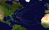
Hurricane Isbell was the final hurricane to affect the United States during the 1964 season. The eleventh tropical storm and sixth hurricane of the season,Isbell developed from a dissipating cold front in the southwestern Caribbean on October 8. The depression initially remained disorganized as it track northwestward,but strengthened into Tropical Storm Isbell on October 13. Re-curving northeastward,Isbell quickly strengthened further and reached hurricane status by later that day. Late on October13,Isbell made landfall in the Pinar del Río Province of Cuba. The storm continued strengthening and peaked as a Category 3hurricane on the following day. Isbell moved northeastward and made landfall near Everglades,Florida,late on October14. After reaching the Atlantic on the following day,the storm began to weaken. Isbell turned northward and continued weakening,before transitioning to an extratropical cyclone while located just offshore eastern North Carolina on October16.
The storm produced strong winds throughout western Cuba. Hundreds of homes were destroyed,as were several tobacco warehouses. There was at least $20million in damage and four deaths in Cuba,three of them caused by collapsing houses in the Guane area. Several tornadoes in Florida caused significant damage. Throughout the state,1 house was destroyed,33 were severely damaged,and 631 suffered minor impact. Additionally,66 trailers were destroyed and 88 were inflicted with major damage. Three deaths occurred in the state,one due to a heart attack and two from drowning in Florida Keys when their shrimp boat sank. Because the storm weakened considerably,impact in North Carolina was generally minor. The storm also spawned at least nine tornadoes in the state,which demolished trailers and unroofed homes and other buildings in several communities. Damage throughout the United States totaled $10 million.
Meteorological history
Map plotting the storm's track and intensity,according to the Saffir–Simpson scale
Hurricane Isbell was first identified as a weak tropical disturbance on October7, 1964 over the western Caribbean. Situated to the south of a diffuse trough, the system remained weak and relatively disorganized as it moved generally northwest near Honduras and Nicaragua. Despite the presence of an upper-level anticyclone, which promotes favorable outflow for tropical cyclones and aids in tropical cyclogenesis, a lack of distinct low-level inflow inhibited intensification. Additionally, an area of warm mid-tropospheric air was present within the cyclone. Though a disheveled system,[1] it is analyzed to have become a tropical depression by 12:00UTC on October8. The following day, the depression skirted the eastern coast of Honduras.[2] Operationally, it was not until October10 that the Weather Bureau initiated advisories on the depression.[1] On that date, a weather reconnaissance mission into the system found a weak low-level circulation with a barometric pressure of 1007.3mb (hPa; 29.75inHg) and winds of 20–30mph (32–48km/h) in squalls.[3] Throughout October11 and 12, the depression slowly executed a tight cyclonic loop over the northwestern Caribbean Sea. It finally organized into a tropical storm and was given the nameIsbell by 00:00UTC on October13 after completing the loop and acquiring a north-northeast trajectory.[2]
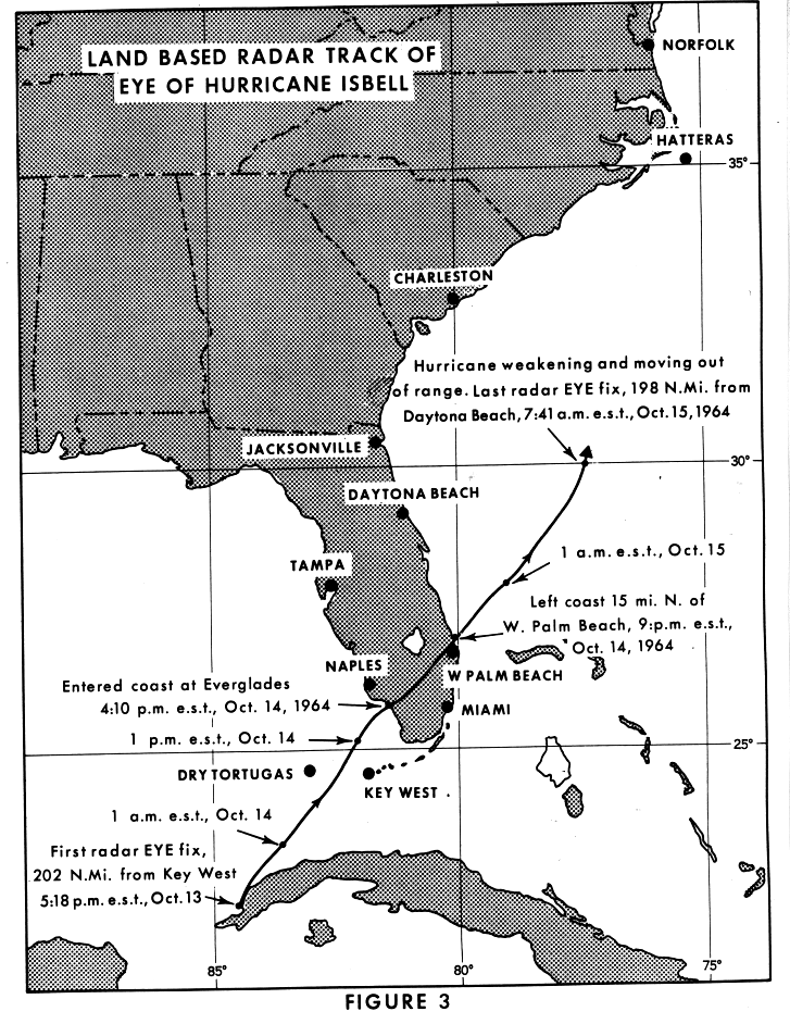
Throughout October13, marked intensification of the cyclone occurred.[1] Over a 24‑hour span, ending at 18:00UTC, its central pressure fell from 1005mb (hPa; 29.68inHg) to 979mb (hPa; 28.91inHg) which was reflected in Isbell's winds more than doubling from 35 to 90mph (56 to 145km/h).[2] Shortly thereafter, the storm made landfall in extreme western Cuba, near Guane, before emerging over the southeastern Gulf of Mexico.[1] Isbell's brief stint over land did not hinder development, which continued unabated until 12:00UTC on October14 at which time it reached its maximum intensity. Situated to the south of Key West, Florida, Isbell attained winds of 125mph (201km/h) which ranks it as a Category 3 hurricane on the modern-day Saffir–Simpson hurricane wind scale. Additionally, its central pressure bottomed out at 964mb (hPa; 28.47inHg).[2] Around this time, a new low-pressure area formed 300mi (480km) to Isbell's northwest over the Gulf in response to a powerful cold-core low over the Mississippi Valley. The cyclonic flow of this second system brought cool, dry air from the north and circulated it into the hurricane. This in turn caused the storm to become asymmetric in structure with radar imagery indicating little to no reflectivity along the western periphery of the hurricane.[1]
Surface weather analysis of Hurricane Isbell and the nearby non-tropical low over the Gulf of Mexico at 12:00UTC on October14.
The degrading structure of Isbell resulted in some weakening as it accelerated toward Florida. At 22:00UTC on October14, the hurricane made landfall near Everglades City as a Category2 with sustained winds between 100 and 110mph (160 and 180km/h).[1][4] Within five hours, the system cleared the Florida Peninsula and emerged over the western Atlantic Ocean north of West Palm Beach.[5] The storm's passage over land resulted in notable weakening, though Isbell remained of hurricane-strength. During the afternoon of October15, the low that had formed the previous day induced a northward turn of the cyclone and directed it toward North Carolina, a result of what is known as the Fujiwhara effect.[1] Thereafter, the two systems began to intertwine as Isbell began transitioning into an extratropical cyclone; rapid weakening accompanied this phase.[6] Isbell completed this process by 12:00UTC on October16 as it moved onshore near Morehead City, North Carolina.[2][6] On October17 the two non-tropical systems merged into a single storm over the Outer Banks.[6] Isbell's remnants emerged back over the Atlantic Ocean on October18 near the Delmarva Peninsula before accelerating northeast. The system was last noted on October19 as it moved over Atlantic Canada.[7]
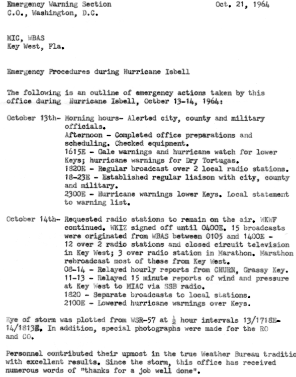
In Cuba, thousands were evacuated due to flooding lowlands.[8] Advisories were broadcast and issued warning of the possibility of heavy rains and winds, isolated small hail, and possible isolated tornadoes in Florida from 21:00UTC on October14 to 02:00UTC on October15. The aviation severe weather forecast also warned residents in south and central Florida of up to 0.75in (19mm) of hail, gusts of up to 53mph (85km/h), and the potential for tornadic activity. Flood warnings were also issued, with predictions of flooding 4ft (1.2m) above flood stage.[9] Emergency preparations at Key West's weather office were made. In the morning hours of October13, the office alerted city, county, and military officials. In the afternoon, they completed office preparations and scheduling. On October14, the office requested radio stations to stay on the air and relayed hourly reports.[10]
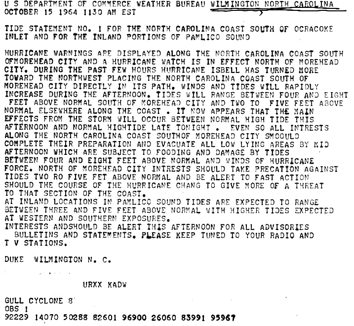
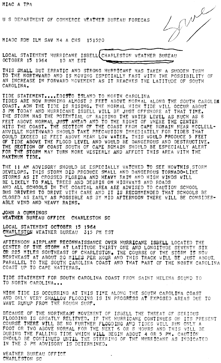
In North Carolina, some tidal flooding was also forecast. People were warned to tune to television and radio broadcasts.[11] On October15, as Isbell rapidly crossed Florida, forecasters at the Charleston, South Carolina Weather Bureau warned of high tides of up to 12ft (3.7m), 5ft (1.5m) above flood-stage, from South Carolina into North Carolina. Owing to the continued northeastward movement of the storm, tides ultimately did not exceed 2ft (0.61m) in South Carolina.[12] Across coastal areas of North Carolina, alerts for severe thunderstorms, tornadoes, and high tides were raised; however, the storm greatly diminished before reaching shore and little damage materialized.[13] Moderate rains along the lower Neuse River basin were expected to prolong flooding triggered by Hurricane Hilda and its remnants earlier in October.[14] Small craft advisories were raised northward to Provincetown, Massachusetts, through October18.[15]
Impact
Map of the Eastern United States depicting rainfall produced by Hurricane Isbell. Between 30 and 80% of the rainfall in Florida fell several days in advance of the storm along a frontal zone.
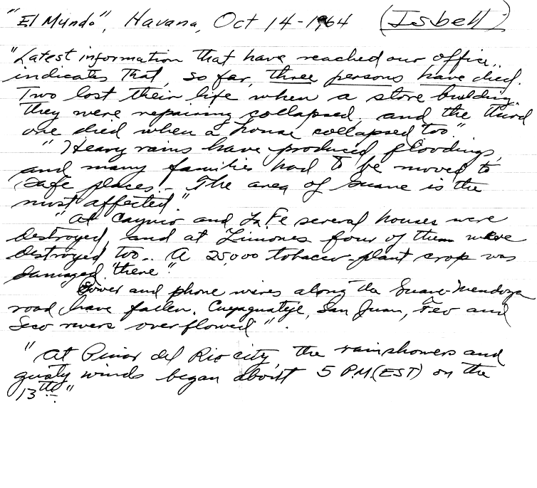
Cuba
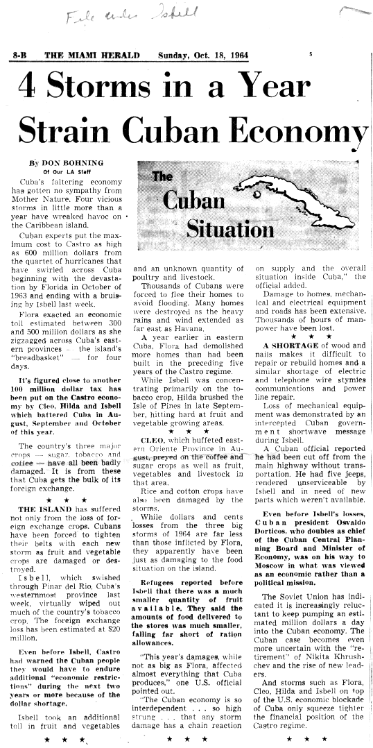
Skirting the extreme western coast of Cuba on October13, the storm produced gusts estimated at 100mph (160km/h) in Pinar del Río Province.[16] The highest measured sustained winds were 85mph (137km/h) in Guane and 70mph (110km/h) at Rancho-Boyeros Airport in the capital city of Havana. Additionally, pressures at the city fell to 979 mbar (hPa; 28.91inHg).[1] Heavy rains caused rivers to over-top their banks, forcing thousands of people to evacuate.[17] Three fatalities occurred in Guane due to collapsing homes.[1][18] A fourth fatality took place elsewhere in Cuba.[19] Numerous homes were damaged or destroyed by the storm, with exact numbers unknown. The region's tobacco crop also sustained considerable losses with fields and warehouses destroyed.[16] The damage to agriculture compounded economic losses in Cuba that resulted from Hurricane Flora in September 1963, which devastated the nation, as well as impacts from Hurricanes Cleo and Hilda earlier in 1964.[20] The combined effects of Cleo, Hilda, and Isbell resulted in economic losses of approximately $100million in the country, of which at least $20million was directly attributed to Isbell.[21]
Though Isbell struck the state as a Category2 hurricane,[4] no winds in excess of 100mph (160km/h) were reported. Measurements peaked at 90mph (140km/h) at both Everglades City and Indiantown. Hurricane-force gusts were measured in Belle Glade, Fort Lauderdale, Key West, Pompano Beach, and West Palm Beach. Atmospheric pressures fell to 970.7mb (hPa; 28.67inHg) in the Dry Tortugas and 977.5mb (hPa; 28.87inHg) on the mainland in Juno Beach.[1] Rainfall in the state was relatively limited owing to the brisk movement of the storm, though a frontal system immediately preceding the hurricane brought heavy rains to the state. A peak total of 9.46in (240mm) was measured in West Palm Beach, though an estimated 80% of this was attributable to the front.[7] Amounts from the hurricane itself were likely around 5in (130mm). No major storm surge was reported during Isbell's passage due to greatly weaker winds in the back half of the storm. Tides in Key West rose 4 to 5ft (1.2 to 1.5m) above normal.[1]
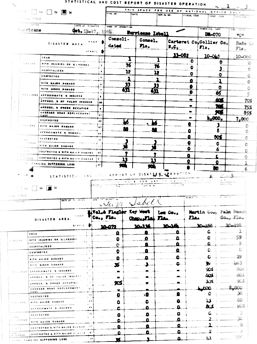
Throughout Florida, three people were killed in relation to the storm and no more than $10million in damage occurred, with more than half of which was attributed to agricultural losses.[1] In addition, 76people were injured, 12of whom required hospitalization. Structural damage was relatively limited, with only 63homes and businesses, mostly trailers, being destroyed; 159other structures sustained major damage while a further 631experienced minor damage.[22] The majority of damage from Isbell was not from the hurricane itself but rather tornadoes spawned by its outer bands.[1] At least nine, and as many as twelve, tornadoes affected the state with the greatest effects being felt in the Miami metropolitan area. All storm-related injuries were attributed to these tornadoes as well as the majority of structural damage.[23] According to the National Climatic Data Center, four of these tornadoes were of F2 intensity.[24]
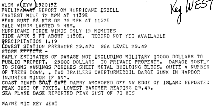
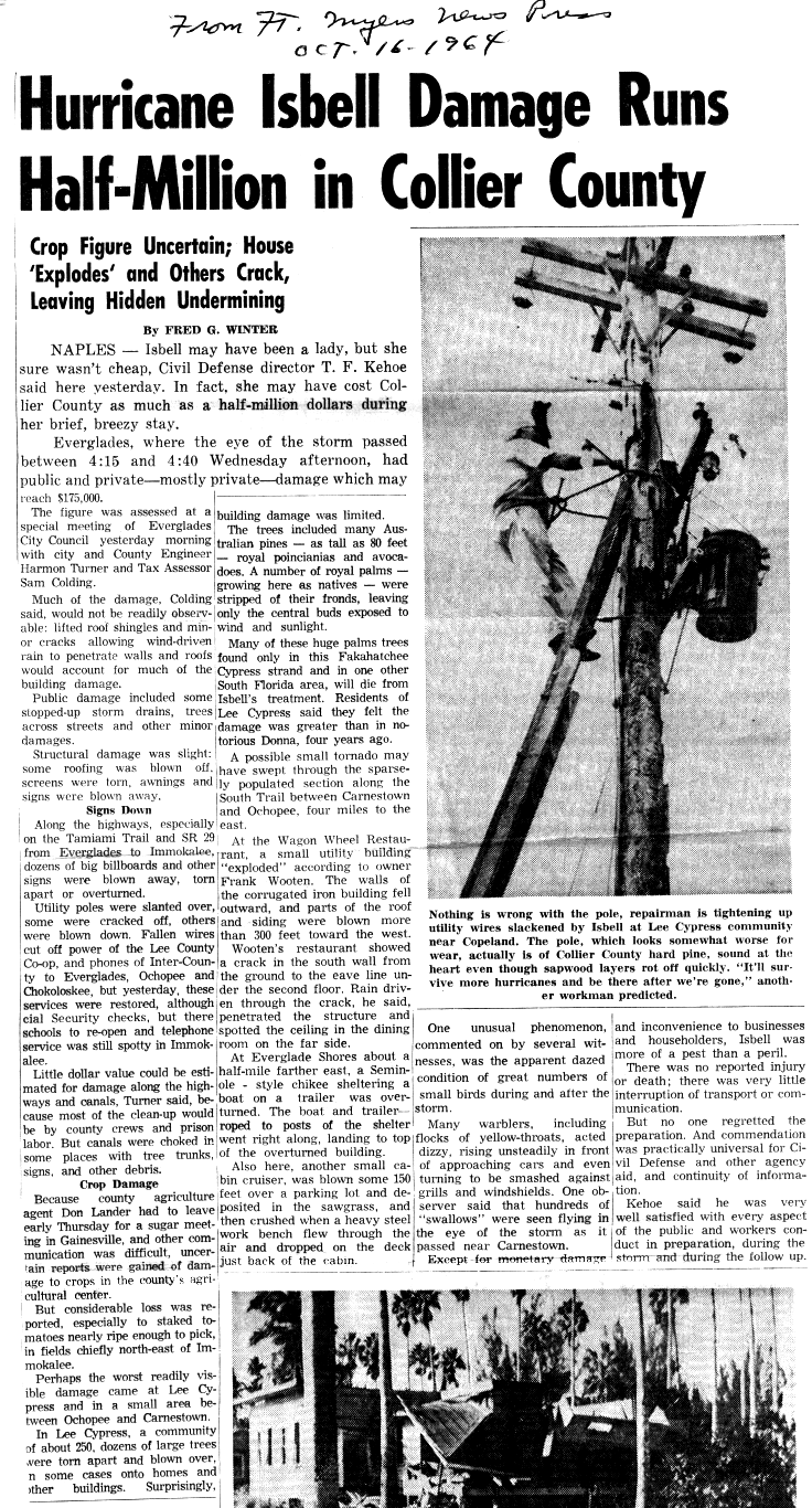
Despite the close passage of the storm to the Florida Keys, damage in the area was light and amounted to $175,000.[1] Of this, $125,000 was attributed to structural damage. Hurricane-force winds in the archipelago only lasted 15minutes and gale-force winds occurred over a 5-hour span. The brevity of damaging winds limited the effects of the storm. Most damage was constrained to downed trees, signs, and power poles. Two trailers were overturned, however, and an oil barge sank in the Key West Harbor.[25] Two people drowned after their shrimp boat was destroyed.[1] In and around the Fakahatchee Strand Preserve State Park, Royal Palms, and Royal Poincianas were defoliated by the hurricane's winds. Downed trees and power lines in Collier County temporarily left many customers without phone and electrical service. Residents in nearby Lee Cypress stated that the effects from Isbell were worse than Hurricane Donna which struck the region as a Category4 in September 1960.[26]
Palm Beach County was the most affected area, accounting for more than half of the losses,[22][27] and approximately $700,000in damage.[28] One indirect death occurred when a man suffered a heart attack in Lake Worth while installing storm shutters.[1][28] At least three tornadoes were spawned in Palm Beach County. The strongest was an F2 that struck a trailer park in Briny Breezes, damaging numerous trailers and injuring 22people. Shortly thereafter the same tornado or possibly a second one struck Boynton Beach, injuring three people and damaging several structures.[23][24] The event lasted roughly 20minutes and the tornadoes moved along a path 10mi (16km) long.[29][30] Another tornado in Boca Raton caused a number of minor injuries. In West Palm Beach, a twister that crossed the intersection of State Roads 802 and 809 damaged adjacent properties and injured several people.[23] Throughout Palm Beach County, 492homes suffered damage, while 36mobile homes were demolished and 60others were inflicted major impact. Additionally, 33farm buildings and 9small businesses were severely damaged or destroyed.[22]
In Martin County, an F2 was spawned in Hobe Sound and affected the area near U.S. Route 1.[23] About 39homes and 13mobile homes were damaged, while two farm buildings and two businesses also received impact.[22] The fourth F2 tornado was spawned in Brevard County near Eau Gallie. It caused extensive damage and injured 17people in the Orange Court trailer park.[23][24] Collectively, 35homes in Flagler and Volusia counties were damaged.[22]
The Carolinas and elsewhere
Surface analysis of Hurricane Isbell's extratropical remnants on October16 over The Carolinas
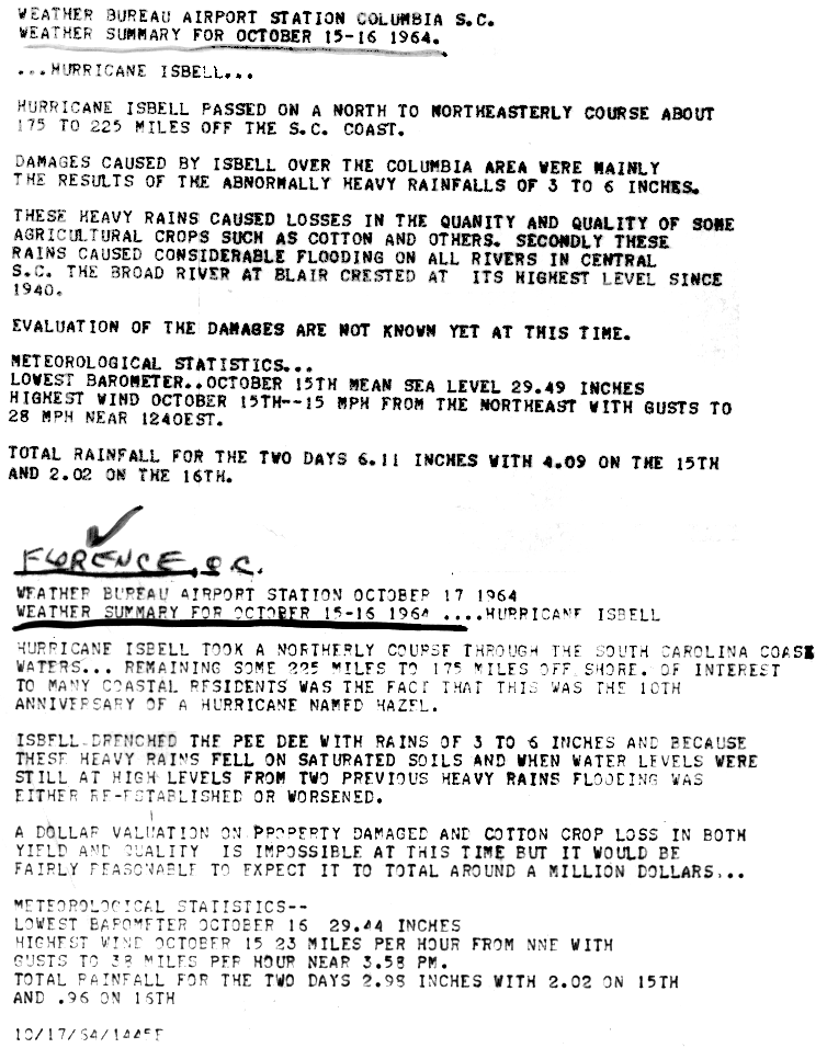
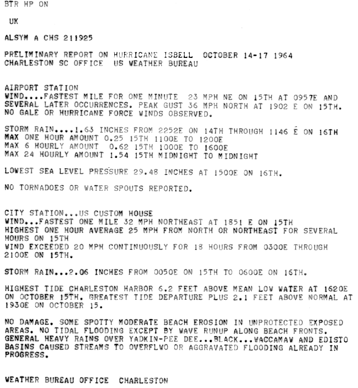
Heavy rains associated with Isbell and a nearby non-tropical low resulted in heavy rains across The Carolinas on October15 and 16. In and around the Columbia, South Carolina area, 3 to 6in (76 to 152mm) of rain fell, with a peak of 6.11in (155mm) in the city itself. Significant flooding took place along all rivers in the state;[31] the Broad River crested at 32.1ft (9.8m), its highest level since 1940, in Blair. The Pee Dee River rose to 39ft (12m) at Cheraw by October18, roughly 9ft (2.7m) above flood-stage.[32] The cotton crop sustained the greatest losses during the event, with damage estimated in excess of $1million.[31] Along the coast, tides rose to 6.2ft (1.9m), 2.1ft (0.64m) above normal, in Charleston Harbor. What little coastal flooding took place mostly resulted from wave run-up rather than tidal flooding. Some beach erosion occurred in exposed areas.[33]
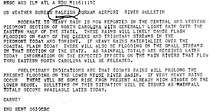
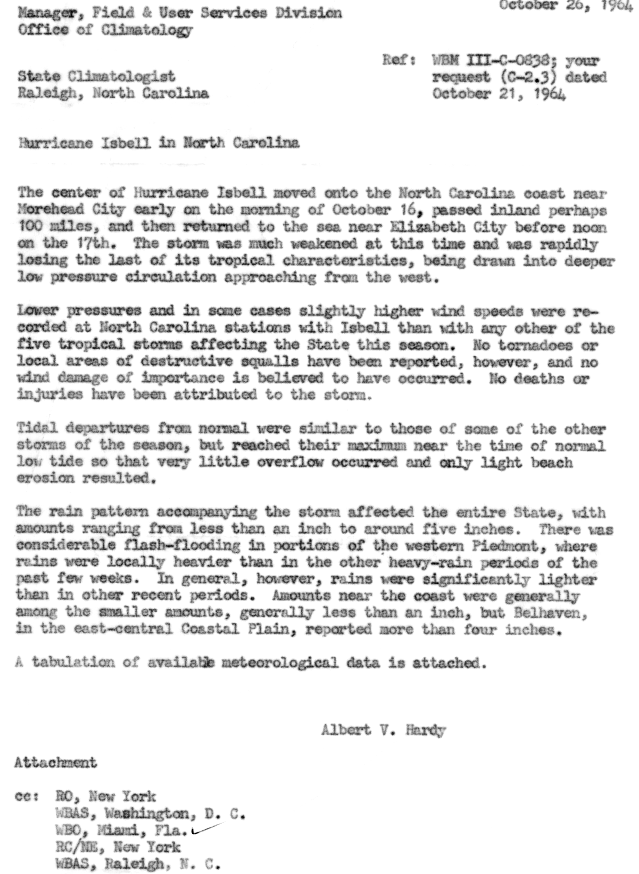
Much of North Carolina was affected by Isbell with rain extending into interior parts of the state. Totals were generally light, however, and peaked at around 5in (130mm) in eastern areas. Some flash flooding took place in the Piedmont, though overall effects were minimal.[34] In the Blue Ridge Mountains, the French Broad River topped its banks and prompted evacuations in Hot Springs and Marshall.[15] The greatest impacts were felt along the Neuse River in Kinston within Lenoir County. Rains from Isbell exacerbated ongoing floods in the area, resulting in heavy damage to many homes.[32] A man was swept away by swift currents near a Duke Energy steam plant in Cliffside; however, it is unknown if he perished or was later rescued.[35] Losses to the peanut crop were extensive, though no monetary value is available.[1] With the storm arriving at low-tide, no notable coastal flooding occurred.[34] The significant weakening of Isbell prior to landfall also lessened the effects from wind as gale-force winds were mostly constrained to coastal areas; a peak gust of 75mph (121km/h) was measured in Elizabeth City.[1]
Elsewhere along the East Coast, the remnants of Isbell produced generally light to moderate rain. A localized maximum of around 5in (130mm) occurred in Massachusetts as the system began to dissipate.[7] Immediately following the storm, an unseasonably strong cold front brought near-freezing temperatures to Virginia, resulting in frost. The combination of the cold air and the hurricane prevented any peanut bumper crop harvesting in the state.[36]
1 2 3 E. Hill (1964). Hurricane Isbell(.GIF). United States Weather Bureau (Report). National Oceanic and Atmospheric Administration. p.2. Retrieved June 20, 2014.
↑ "Isbell Takes Dead Aim on North Carolina Coast". The Daily Times News. Associated Press. October 15, 1964.
↑ Magor (October 14, 1964). "Severe Weather Forecast Number 460"(.GIF). United States Weather Bureau. National Oceanic and Atmospheric Administration. Retrieved August 30, 2015.
↑ "Emergency Procedures during Hurricane Isbell". United States Weather Bureau Airport Station Key West, Florida. National Oceanic and Atmospheric Administration. October 21, 1964. Retrieved August 30, 2015.
↑ Duke (October 15, 1964). "Tide Statement No. 1". United States Weather Bureau Office Wilmington, North Carolina. National Oceanic and Atmospheric Administration. Retrieved August 30, 2015.
↑ John A. Cummings (October 16, 1964). "Local Statement: Hurricane Isbell"(.GIF). United States Weather Bureau Office in Charleston, South Carolina. National Oceanic and Atmospheric Administration. Retrieved June 17, 2014.
↑ "Power Lost by Hurricane Isbell". The Daily Telegram. Norfolk, Virginia. United Press International. October 17, 1964. p.15. Retrieved June 17, 2014.–viaNewspapers.com (subscription required)
1 2 "Hurricane Remnants Now At Sea". San Antonio Express. Norfolk, Virginia. Associated Press. October 18, 1964. p.56. Retrieved June 20, 2014.–viaNewspapers.com (subscription required)
1 2 3 4 5 Robert M. White, United States Weather Bureau (1964). Storm Data and Unusual Weather Phenomena: October 1964(PDF). National Climatic Data Center (Report). Vol.6. Asheville, North Carolina: National Oceanic and Atmospheric Administration. pp.2–3. Archived from the original(PDF) on August 30, 2015. Retrieved August 30, 2015.
↑ "Preliminary Report on Hurricane Isbell"(.GIF). United States Weather Bureau Office in Key West, Florida. National Oceanic and Atmospheric Administration. October 15, 1964. Retrieved June 18, 2014.
1 2 "Hurricane Isbell"(.GIF). United States Weather Bureau. National Oceanic and Atmospheric Administration. October 17, 1964. Retrieved June 18, 2014.
1 2 "Cleanup Begins Of Tar Heel Flood Areas". Florence Morning News. Associated Press. October 19, 1964. p.2. Retrieved June 20, 2014.–viaNewspapers.com (subscription required)
1 2 Albert V. Hardy (October 26, 1964). "Hurricane Isbell in North Carolina"(.GIF). Office of Climatology. National Oceanic and Atmospheric Administration. Retrieved June 18, 2014.
↑ "Winded Isbell Quits; Leaves Sky All Clear". The Odessa American. Norfolk, Virginia. Associated Press. October 18, 1964. p.3. Retrieved June 20, 2014.–viaNewspapers.com (subscription required)
↑ "Bumper Peanut Ruled Out". The Progress-Index. Suffolk, Virginia. Associated Press. October 19, 1964. p.10. Retrieved June 20, 2014.–viaNewspapers.com (subscription required)
This page is based on this Wikipedia article Text is available under the CC BY-SA 4.0 license; additional terms may apply. Images, videos and audio are available under their respective licenses.


