Briny Breezes, Florida

Last updated

Briny Breezes, Florida
Town of Briny Breezes
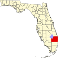
Map of Florida highlighting Briny Breezes.svg
Location of Briny Breezes, Florida
Coordinates: 26°30′32″N80°3′15″W / 26.50889°N 80.05417°W / 26.50889; -80.05417
Country Flag of the United States.svg  United States
State Flag of Florida.svg  Florida
County Flag of Palm Beach County, Florida.png Palm Beach
Incorporated March 19, 1963 [1] [2]
Government
  Type Council-manager [3]
   Mayor [3] Ted Gross
   Council President [3] Elizabeth "Liz" Loper
   Alderman [3] Jeff Duncan,
Kathy Gross,
Bill Birch, and
Keith Black
   Town Manager [3] William "Bill" Thrasher
   Town Clerk [3] Sandi DuBose
Area
[4]
  Total0.11 sq mi (0.27 km2)
  Land0.06 sq mi (0.15 km2)
  Water0.05 sq mi (0.13 km2)
Elevation
13 ft (4 m)
Population
 (2020)
  Total502
  Density8,807.02/sq mi (3,388.41/km2)
Time zone UTC-5 (Eastern (EST))
  Summer (DST) UTC-4 (EDT)
ZIP code
33435
Area code(s) 561, 728
FIPS code 12-08575 [5]
GNIS feature ID0302720 [6]
Website www.brinybreezes.us

Briny Breezes is a town in Palm Beach County, Florida, United States. The town is part of the Miami metropolitan area of South Florida. Briny Breezes (or "Briny" as it is known locally) is a small coastal community of approximately 488 mobile homes along State Road A1A. Briny is a private community consisting mostly of "snowbirds" from the Northeastern, the Midwest, and Canada. It and Ocean Breeze are the only two mobile home parks in Florida that are incorporated towns. The population was 502 at the 2020 US census.
Contents

History

In the 1920s, the land housed a strawberry farm owned by Michigan lumberman Ward Miller. [7] Around the time of the Great Depression, he allowed tourists, who brought their trailers down from the North, to camp on his land. He began advertising the land by placing flyers in Northern newspapers, such as the Chicago Tribune , that touted Briny's "$3 a week rent." [8] In 1958, Miller wanted to retire and made an offer to the campers to buy the land: $2,000 per lot and $2,500 for those near the water. [8] The campers brought their assets together and the town was incorporated on March 19, 1963, complete with its own mayor and post office. [1]

The town's first mayor was Hugh David. He held office until his death in 1997, and was never opposed in an election. [9] His successor, Robert Conkey, also died in office only months into his second term in 2000. [10] Conkey's second term was notable as he won the election by only five votes. [11]

In its beginnings, the town was mainly made up of families that came to live during the winter. [8] Now, the residents are senior citizens that live there either year round or just in the winter. [1]

Briny Breezes was used as the setting for the 2005 film In Her Shoes , and many of its residents served as extras in the movie. [12] Parts of the 1992 comedy-drama movie Folks!, starring Tom Selleck and Don Ameche, were also filmed in Briny Breezes.

Development

In October 2005, developer Jean Francois Roy, of Ocean Land Investments, made an offer to buy the entire town for $500 million. [13] This would equate to an average of slightly more than $1 million per residential lot. [8] In December 2005, it was announced that 73 percent of the 488 lot owners had voted to hire a lawyer to pursue the sale. [14] Later, Roy raised his offer to $510 million. [13]

Had the sale gone through, it would have meant a huge windfall for each lot owner. Many people paid between $30,000 and $40,000 when they purchased their homes. [1] In comparison, the 2000 census reported $129,000 was the median value of a home in Briny. [8]

A vote to ratify the deal was set for January 10, 2007, and 80 percent of residents approved of the sale, with 97 percent of owners voting. The residents would not receive any compensation until 2009 and the plan was yet to be approved by state and local officials, due to zoning concerns. [15]

However, on July 30, 2007, when the "earnest money" was due to the town, the deal was cancelled by the land developer over a dispute with the town board of directors over how long a period was to be allowed for due diligence. [16]

Geography

Briny Breezes is located at 26°30′32″N80°3′15″W / 26.50889°N 80.05417°W / 26.50889; -80.05417 (26.508849, –80.054150). [17]

It is about 1.6 miles south of Ocean Ridge and 1.3 miles north of Gulf Stream and sits between the Atlantic Ocean on the east and the Intracoastal Waterway to the west.

According to the United States Census Bureau, the town has a total area of 0.1 square miles (0.26 km2), of which 0.1 square miles (0.26 km2) is land and 0.04 square miles (0.10 km2) (22.22%) is water.

Climate

The Town of Briny Breezes has a tropical climate, similar to the climate found in much of the Caribbean. It is part of the only region in the 48 contiguous states that falls under that category. More specifically, it generally has a tropical savanna climate (Köppen climate classification: Aw), bordering a tropical monsoon climate (Köppen climate classification: Am). [18]

Demographics

Historical population
CensusPop.Note
1970 481
1980 387−19.5%
1990 4003.4%
2000 4112.8%
2010 60146.2%
2020 502−16.5%
U.S. Decennial Census [19]

2010 and 2020 census

Briny Breezes racial composition
(Hispanics excluded from racial categories)
(NH = Non-Hispanic)
RacePop 2010 [20] Pop 2020 [21] % 2010% 2020
White (NH)59447998.84%95.42%
Black or African American (NH)200.33%0.00%
Native American or Alaska Native (NH)000.00%0.00%
Asian (NH)020.00%0.40%
Pacific Islander or Native Hawaiian (NH)000.00%0.00%
Some other race (NH)020.00%0.40%
Two or more races/Multiracial (NH)030.00%0.60%
Hispanic or Latino (any race)5160.83%3.19%
Total601502

As of the 2020 United States census, there were 502 people, 427 households, and 214 families residing in the town. [22]

As of the 2010 United States census, there were 601 people, 407 households, and 218 families residing in the town. [23]

2000 census

As of the census [5] of 2000, there were 411 people, 266 households, and 129 families residing in the town. The population density was 5,912.5 inhabitants per square mile (2,282.8/km2). There were 534 housing units at an average density of 7,682.0 per square mile (2,966.0/km2). The racial makeup of the town was 99.27% White, 0.49% Asian, and 0.24% from other races. Hispanic or Latino of any race were 0.49% of the population.

In 2000, there were 266 households, out of which 1.9% had children under the age of 18 living with them, 44.7% were married couples living together, 2.6% had a female householder with no husband present, and 51.5% were non-families. 48.5% of all households were made up of individuals, and 34.2% had someone living alone who was 65 years of age or older. The average household size was 1.55 and the average family size was 2.06.

In 2000, in the town, the population was skewed toward mostly older persons with 1.9% under the age of 18, 1.5% from 18 to 24, 4.9% from 25 to 44, 25.3% from 45 to 64, and 66.4% who were 65 years of age or older. The median age was 70 years. For every 100 females, there were 77.9 males. For every 100 females age 18 and over, there were 76.0 males.

In 2000, the median income for a household in the town was $34,583, and the median income for a family was $55,500. Males had a median income of $31,250 versus $33,333 for females. The per capita income for the town was $35,338. About 1.5% of families and 6.6% of the population were below the poverty line, including none of those under age 18 and 5.6% of those age 65 or over.

As of 2000, speakers of English as a first language accounted for 100% of all residents. It, along with Cloud Lake, and Golf, and Jupiter Inlet Colony were the only municipalities in Palm Beach county with all residents having the mother tongue of English. [24]

Related Research Articles

<span class="mw-page-title-main">Ocean Breeze, Florida</span> Town in the state of Florida, United States

Ocean Breeze, formerly Ocean Breeze Park, is a town on the Indian River in Martin County, Florida, United States. Ocean Breeze and Briny Breezes in Palm Beach County are the only two towns in Florida in which all residents live in a mobile home park bearing the name of the town. The population was 301 at the 2020 census. The population figures do not include the many part-time winter residents from other places. The town is bordered on three sides by the unincorporated community of Jensen Beach.

<span class="mw-page-title-main">Boynton Beach, Florida</span> City in Florida, United States

Boynton Beach is a city in Palm Beach County, Florida, United States. It is situated about 57 miles (92 km) north of Miami. The 2020 census recorded a population of 80,380. Boynton Beach is located in the Miami metropolitan area, which was home to 6,138,333 people at the 2020 census. The city is named after Nathan Boynton, a Civil War major and Michigan politician who became one of the first settlers in the area in 1895. Boynton Beach is located north of Delray Beach, south of Hypoluxo and Lantana, and east of Golf, while the municipalities of Briny Breezes, Gulf Stream, Manalapan, and Ocean Ridge are situated to the east across the Intracoastal Waterway.

<span class="mw-page-title-main">Canal Point, Florida</span> CDP in Florida, United States

Canal Point is a census-designated place (CDP) and unincorporated community in Palm Beach County, Florida, United States. It is part of the Miami metropolitan area of South Florida despite its local culture and location being way more similar to the Florida Heartland. Canal Point has a population of 344 people counted in the 2020 US census.

<span class="mw-page-title-main">Cloud Lake, Florida</span> Town in the state of Florida, United States

Cloud Lake is a town in Palm Beach County, Florida, United States. It is part of the Miami metropolitan area of South Florida. As of the 2020 US census, the town had a population of 134 residents.

<span class="mw-page-title-main">Glen Ridge, Florida</span> Town in Florida, United States

Glen Ridge is a town and registered bird sanctuary in Palm Beach County, Florida, United States. It is part of the Miami metropolitan area of South Florida. The population was 217 in the 2020 US census.

<span class="mw-page-title-main">Golf, Florida</span> Village in Florida, United States

The Village of Golf is a village in Palm Beach County, Florida, United States. It's also part of the Miami metropolitan area of South Florida. As of 2020, the population recorded by the U.S. Census Bureau was 255.

<span class="mw-page-title-main">Greenacres, Florida</span> City in Florida, United States

Greenacres is a city in Palm Beach County, Florida, United States. It is part of the Miami metropolitan area in South Florida. As of the 2020 census, the city had a population of 43,990 residents.

<span class="mw-page-title-main">Gulf Stream, Florida</span> Town in the state of Florida, United States

Gulf Stream is a town in Palm Beach County, Florida, United States. It is part of the Miami metropolitan area of South Florida. The population of the town was at 954 as of the 2020 US Census.

Gun Club Estates is a census-designated place (CDP) in Palm Beach County, Florida, United States. It is part of the Miami metropolitan area of South Florida. The population was 816 at the 2020 US census.

<span class="mw-page-title-main">Haverhill, Florida</span> Town in the state of Florida, United States

Haverhill is a town in Palm Beach County, Florida, United States. It is a part of the Miami metropolitan area of South Florida. Haverhill became a town on May 3, 1950, and was named after the city of Haverhill, Massachusetts. The town is located in east-central Palm Beach County near the western periphery of the Palm Beach International Airport, and is also small geographically, encompassing just 0.63 square miles (1.6 km2). The population of the town was 2,187 as of the 2020 US Census.

<span class="mw-page-title-main">Highland Beach, Florida</span> Town in the state of Florida, United States

Highland Beach is a town in Palm Beach County, Florida, United States. It is part of the Miami metropolitan area of South Florida, and situated 50 miles north of Miami and 28 miles south of Palm Beach. As of the 2020 US census, the population was 4,295.

<span class="mw-page-title-main">Juno Beach, Florida</span> Town in the state of Florida, United States

Juno Beach is a town in Palm Beach County, Florida, United States. Juno Beach is home to the headquarters of Florida Power & Light, the Loggerhead Marinelife Center and the Seminole Golf Club. It was also the original county seat for the area that was then known as Dade County. Juno Beach is in the Miami metropolitan area. The political climate in Juno Beach is leaning liberal. The property crime rate is around the US national average, with the violent crime rate well below average. The Town of Juno Beach was officially incorporated in 1953. As of 2020, the town's population recorded by the U.S. Census Bureau was 3,858.

<span class="mw-page-title-main">Jupiter, Florida</span> Town in the state of Florida, United States

Jupiter is the northernmost town in Palm Beach County, Florida, United States. According to the 2020 US Census, the town had a population of 61,047. It is 84 miles north of Miami and 15 miles north of West Palm Beach. Along with the adjacent Village of Tequesta, Jupiter is considered the northernmost municipality in the Miami metropolitan area. It was named the 9th Best Southern Beach Town to live in by Stacker Newsletter for 2022, was rated as the 12th Best Beach Town in the United States by WalletHub in 2018, and as the 9th Happiest Seaside Town in the United States by Coastal Living in 2012.

<span class="mw-page-title-main">Jupiter Inlet Colony, Florida</span> Town in the state of Florida, United States

Jupiter Inlet Colony is a town in Palm Beach County, Florida, United States. The town was incorporated in 1959 and is part of the Miami metropolitan area of South Florida. The population was 405 at the 2020 US census.

<span class="mw-page-title-main">Manalapan, Florida</span> Town in the state of Florida, United States

Manalapan is a town in Palm Beach County, Florida, United States. It is part of the Miami metropolitan area of South Florida. The population was 419 at the 2020 United States census.

<span class="mw-page-title-main">Mangonia Park, Florida</span> Town in the state of Florida, United States

Mangonia Park is a town in Palm Beach County, Florida, United States. It is a part of the Miami metropolitan area of South Florida as well as Uptown West Palm, which includes the cities of Riviera Beach and West Palm Beach. As of 2020, the population recorded by the U.S. Census Bureau was 2,142.

<span class="mw-page-title-main">Ocean Ridge, Florida</span> Town in the state of Florida, United States

Ocean Ridge is a town in Palm Beach County, Florida, United States. The town is part of the Miami metropolitan area of South Florida. The population was 1,830 at the 2020 US census.

<span class="mw-page-title-main">Riviera Beach, Florida</span> City in Florida, United States

Riviera Beach is a city in Palm Beach County, Florida, United States, which was incorporated on September 29, 1922. Due to the location of its eastern boundary, it is also the easternmost municipality in the Miami metropolitan area. In the 2020 U.S. Census, the total population of Riviera Beach residents was 37,604 people.

<span class="mw-page-title-main">South Bay, Florida</span> City in Florida, United States

South Bay is a city in Palm Beach County, Florida, United States. It is the westernmost municipality in the South Florida metropolitan area. As of 2020, the population recorded by the U.S. Census Bureau was 4,860 residents. While the current estimates place South Bay's population in the incorporated city limits at more than 4,000 people, surrounding areas increase the population figures to 54,000 people in a 25-mile (40 km) radius and more than 1.4 million in a 50-mile (80 km) radius.

<span class="mw-page-title-main">Redington Shores, Florida</span> Town in the state of Florida, United States

Redington Shores is a town in Pinellas County, Florida, United States. The county is part of the Tampa–St. Petersburg–Clearwater Metropolitan Statistical Area, more commonly known as the Tampa Bay Area. The population was 2,176 at the 2020 census.

References

  1. 1 2 3 4 Luscombe, Richard. Backstory: Briny beach memoirs. The Christian Science Monitor , June 8, 2006. Retrieved January 7, 2007.
  2. "MUNICIPAL DIRECTORY: Town of Briny Breezes". www.floridaleagueofcities.com. Retrieved June 8, 2024.
  3. 1 2 3 4 5 6 "Our 39 Municipal Members Listings". The Palm Beach County League of Cities. Retrieved June 8, 2024.
  4. "2020 U.S. Gazetteer Files". United States Census Bureau. Retrieved October 31, 2021.
  5. 1 2 "U.S. Census website". United States Census Bureau . Retrieved January 31, 2008.
  6. "US Board on Geographic Names". United States Geological Survey. October 25, 2007. Retrieved January 31, 2008.
  7. About the Briny Breezes deal [ permanent dead link ]. Sun-Sentinel , December 13, 2006. Retrieved January 7, 2007.
  8. 1 2 3 4 5 DeGregory, Lane. A Price on Paradise. St. Petersburg Times , February 5, 2006. Retrieved January 7, 2007.
  9. Kleinberg, Eliot. "Hugh David, Briny Breezes' Only Mayor, Dies at 75." The Palm Beach Post , February 22, 1997.
  10. FL Mayor Dies Archived September 27, 2007, at the Wayback Machine . The Florida Times-Union, September 21, 2000. Retrieved January 7, 2007.
  11. Kleinberg, Eliot. "Five votes put Conkey back in mayor's post." The Palm Beach Post, March 15, 2000.
  12. Production Notes: In Her Shoes. CinemaReview.com. Retrieved February 24, 2008.
  13. 1 2 Kleinberg, Eliot & Meyer, Meghan. Trailer park windfall: $510 million for Briny Breezes. The Palm Beach Post, December 13, 2006. Retrieved January 7, 2007.
  14. Cornwall, Rupert. Briny Breezes trailer park offered $500m to blow away Archived October 1, 2007, at the Wayback Machine . The Independent , December 28, 2005. Retrieved January 7, 2007.
  15. Kennedy, Kelli. Mobile home owners may share millions. Associated Press , January 11, 2007. Retrieved January 15, 2007.
  16. Duggan, Ed. $510M Briny Breezes deal cancelled. South Florida Business Journal, July 30, 2007. Retrieved February 24, 2008.
  17. "US Gazetteer files: 2010, 2000, and 1990". United States Census Bureau. February 12, 2011. Retrieved April 23, 2011.
  18. "Köppen Climate Classification Map: South Florida=Am/Aw=tropical wet & dry". Archived from the original on July 6, 2011.
  19. "Census of Population and Housing". Census.gov. Retrieved June 20, 2023.
  20. "P2 HISPANIC OR LATINO, AND NOT HISPANIC OR LATINO BY RACE - 2010: DEC Redistricting Data (PL 94-171) - Briny Breezes town, Florida". United States Census Bureau .
  21. "P2 HISPANIC OR LATINO, AND NOT HISPANIC OR LATINO BY RACE - 2020: DEC Redistricting Data (PL 94-171) - Briny Breezes town, Florida". United States Census Bureau .
  22. "HOUSEHOLDS AND FAMILIES". data.census.gov. Retrieved June 20, 2023.
  23. "HOUSEHOLDS AND FAMILIES". data.census.gov. Retrieved June 20, 2023.
  24. "MLA Data Center Results for Briny Breezes, Florida". Modern Language Association . Retrieved December 3, 2007.