Sunny Isles Beach, Florida

Last updated

Sunny Isles Beach, Florida
City of Sunny Isles Beach
Jade Signature, Jade Beach, Jade Ocean, Muse, Ocean 4, Chateau Beach March 2018 Sunny Isles.jpg
Sunny Isles Beach skyline
Sunnyislesbeachseal.jpg
Motto(s): 
The City of Sun and Sea
Miami-Dade County Florida Incorporated and Unincorporated areas Sunny Isles Beach Highlighted.svg
Location in Miami-Dade County and the state of Florida
Sunny Isles Beach.gif
U.S. Census Bureau map showing city limits
Coordinates: 25°56′30″N80°07′30″W / 25.94167°N 80.12500°W / 25.94167; -80.12500
Country Flag of the United States.svg  United States of America
State Flag of Florida.svg  Florida
County Flag of Miami-Dade County, Florida.png Miami-Dade
Incorporated June 16, 1997
Government
  Type Council-Manager
   Mayor Larisa Svechin [1]
   Vice Mayor Jerry Joseph
   Commissioners Jeniffer Viscarra,
Alex Lama, and
Fabiola Stuyvesant
   City Manager Stan Morris
   City Clerk Mauricio Betancur
Area
[2]
  Total1.81 sq mi (4.69 km2)
  Land1.01 sq mi (2.62 km2)
  Water0.80 sq mi (2.08 km2)
Population
 (2020) [3]
  Total22,342
  Density22,098.91/sq mi (8,536.02/km2)
Time zone UTC−05:00 (Eastern (EST))
  Summer (DST) UTC−04:00 (EDT)
ZIP Code
33160
Area code(s) 305, 786, 645
FIPS code 12-69550 [4]
Website www.sibfl.net
Sunny Isles Beach, Florida

Sunny Isles Beach (SIB or more commonly Sunny Isles, and officially the City of Sunny Isles Beach) is a city located on a barrier island in northeast Miami-Dade County, Florida, United States. The city is part of the Miami metropolitan area of South Florida, and is bounded by the Atlantic Ocean on the east and the Intracoastal Waterway on the west. As of the 2020 census, it had a population of 22,342. [3]

Contents

Sunny Isles Beach is an area of cultural diversity with stores lining Collins Avenue, the main thoroughfare through the city. It is renowned for having the 14th tallest skyline in the United States, and according to the 2020 U.S. Census it was the mostly densely populated incorporated place in the United States outside of the New York City metropolitan area.

Developers like Michael Dezer have invested heavily in construction of high-rise hotels and condominiums while licensing the Donald Trump name for some of the buildings for promotional purposes. [5] Sunny Isles Beach has a central location, minutes from Bal Harbour to the south, and Aventura to the north and west.

Sunny Isles Beach was the 2008 site of MTV's annual Spring Break celebration, with headquarters at the local Newport Beachside Resort. [6]

History

View of Sunny Isles Beach from the coast View of Sunny Isles Beach From The Coast.jpg
View of Sunny Isles Beach from the coast

In 1920, Harvey Baker Graves, a private investor, purchased a 2.26-square-mile (5.9 km2) tract of land for development as a tourist resort. He named it "Sunny Isles, the America Riviera". [7]

When the Haulover bridge was completed in 1925, the area became accessible from Miami Beach, attracting developers who widened streams, dug canals and inlets and created islands and peninsulas for building waterfront properties on Biscayne Bay. [7]

Sunny Isles Beach was known as North Miami Beach until 1931, then known as Sunny Isles until 1997. [8]

In 1936, Milwaukee malt magnate Kurtis Froedtert bought Sunny Isles. [9] The Sunny Isles Pier was built and soon became a popular destination. Sunny Isles developed slowly until the 1950s when the first single-family homes were built in the Golden Shores area. During the 1950s and 1960s more than 30 motels sprang up along Collins Avenue including the Ocean Palm, the first two-story motel in the U.S. Designed by Norman Giller in 1948 it was developed and owned by the Gingold family for the next 45 years and provided the springboard for Sunny Isles economic development. Tourists came from all over to vacation in themed motels of exotic design along "Motel Row". [7] One motel, The Fountainhead, was named by its owner Norman Giller after the novel by Ayn Rand. [10] As of 2013, the Ocean Palm Motel is closed.[ citation needed ]

In 1982 the half-mile-long Sunny Isles Pier was designated a historic site. In the early-mid 1980s, it went through restoration and re-opened to the public in 1986. [11] The pier was damaged severely in October 2005 by Hurricane Wilma. After eight years, it was remodeled and reopened as Newport Fishing Pier on June 15, 2013. [12]

In 1997, the citizens of the area voted to incorporate as a municipality. Sunny Isles was renamed Sunny Isles Beach. [13] Sunny Isles Beach began major redevelopment during the real estate boom of the early 2000s with mostly high-rise condominiums and some hotels under construction along the beach side of Collins Avenue (A1A) replacing most of the historic one- and two-story motels along Motel Row. In 2011, construction began on two more high-rises, Regalia, located on the northern border of the city along A1A, and The Mansions at Acqualina, [14] located adjacent to the Acqualina Resort & Spa on the Beach.

Geography

Sunny Isles Beach is located in northeastern Miami-Dade County at 25°56′30″N80°7′30″W / 25.94167°N 80.12500°W / 25.94167; -80.12500 (25.941270, –80.125111). [15] It is bordered to the north by the town of Golden Beach, to the west across the Intracoastal Waterway by the cities of Aventura and North Miami Beach, to the south by Miami-Dade County's Haulover Park, and to the east by the Atlantic Ocean.

Florida State Road A1A is the main road through the city, leading north 4 miles (6 km) to Hollywood Beach and south 10 miles (16 km) to the center of Miami Beach. State Road 826 (Sunny Isles Boulevard) leads west into North Miami Beach, and State Road 856 (the William Lehman Causeway) leads west into Aventura from the north end of Sunny Isles Beach.

According to the United States Census Bureau, the city has a total area of 1.8 square miles (4.7 km2), with 1.0 square mile (2.6 km2) of it land and 0.8 square miles (2.1 km2) of it (44.24%) as water. [2]

Surrounding areas

Demographics

Historical population
CensusPop.Note
2000 15,315
2010 20,83236.0%
2020 22,3427.2%
U.S. Decennial Census [16]

2020 census

Sunny Isles Beach racial composition
(Hispanics excluded from racial categories)
(NH = Non-Hispanic) [17]
RaceNumberPercentage
White (NH)11,85853.07%
Black or African American (NH)3591.61%
Native American or Alaska Native (NH)120.05%
Asian (NH)3441.54%
Pacific Islander or Native Hawaiian (NH)20.01%
Some other race (NH)2491.11%
Two or more races/Multiracial (NH)1,1245.03%
Hispanic or Latino 8,39437.57%
Total22,342

As of the 2020 United States census, there were 22,342 people, 10,666 households, and 5,309 families residing in the city. [18]

2010 census

Sunny Isles Beach Demographics
2010 Census Sunny Isles BeachMiami-Dade CountyFlorida
Total population20,8322,496,43518,801,310
Population, percent change, 2000 to 2010+36.0%+10.8%+17.6%
Population density20,518.9/sq mi1,315.5/sq mi350.6/sq mi
White or Caucasian (including White Hispanic)90.6%73.8%75.0%
(Non-Hispanic White or Caucasian)50.2%15.4%57.9%
Black or African-American 3.2%18.9%16.0%
Hispanic or Latino (of any race) 44.4%65.0%22.5%
Asian 1.4%1.5%2.4%
Native American or Native Alaskan 0.2%0.2%0.4%
Pacific Islander or Native Hawaiian 0.0%0.0%0.1%
Two or more races (Multiracial) 2.2%2.4%2.5%
Some Other Race 2.4%3.2%3.6%

As of the 2010 United States census, there were 20,832 people, 10,266 households, and 5,183 families residing in the city. [19]

2000 census

In 2000, 12.6% had children under the age of 18 living with them, 37.8% were married couples living together, 8.0% had a female householder with no husband present, and 51.1% were non-families. 43.9% of all households were made up of individuals, and 23.5% had someone living alone who was 65 years of age or older. The average household size was 1.87 and the average family size was 2.55.

In 2000, the city's population was spread out, with 11.3% under the age of 18, 5.4% from 18 to 24, 26.9% from 25 to 44, 24.3% from 45 to 64, and 32.2% who were 65 years of age or older. The median age was 50 years. For every 100 females, there were 86.3 males. For every 100 females age 18 and over, there were 83.6 males.

In 2000, the median income for a household in the city was $31,627, and the median income for a family was $40,309. The per capita income for the city was $27,576. About 11.2% of families and 14.7% of the population were below the poverty line, including 18.9% of those under age 18 and 12.2% of those age 65 or over.

As of 2000, Spanish was the mother tongue for 40.08%, while English was spoken by 36.86% of all residents. Living up to its nickname of "Little Moscow," 7.37% of the population had Russian as their first language. Other languages included French (4.08%), Yiddish (2.63%), Hebrew (2.42%), Portuguese (2.01%), Polish (1.38%), Hungarian (0.93%), Italian (0.69%), Arabic (0.66%), German (0.55%), and French Creole (0.35%). [20]

City of Sunny Isles Beach by night Sunny-isles-1.JPG
City of Sunny Isles Beach by night

Also, as of 2010, the six main ancestries of the population (excluding Hispanic ancestry) were 9.4% Russian, 5.8% Italian, 5.0% Polish, 4.9% American, 2.9% Irish, and 2.7% German. [21]

Education

Sunny Isles Beach is within the Miami-Dade County Public Schools system.

All residents are zoned to Norman S. Edelcup/Sunny Isles Beach K–8 for elementary and K–8. [22]

Prior to August 2008 residents were zoned to an elementary school as follows: [23]

The Norman S. Edelcup/Sunny Isles Beach K–8, with four stories, is currently educating students from kindergarten through 8th grade from all of Sunny Isles Beach and Golden Beach as well as the Eastern Shores neighborhood of North Miami Beach. The school can hold up to 1,600 students. The school opened in August 2008 as a K–6, with grades 7 and 8 introduced in the subsequent two school years. [24] The school has or is currently participating[ when? ] in: Accelerated Reader, VMath Live, mock elections, book drives, toy drives, etc. The school has state of the art technology that includes Smart Boards and surround sound microphones for both teachers and students. The school has Intracoastal and ocean views from almost every classroom on the 2nd, 3rd, 4th, and 5th floors.[ citation needed ] Sunny Isles Beach spent $12.5 million so the school district could buy the land. The anticipated 2008 enrollment of city residents in the school was about 900. [23] It was originally known as Sunny Isles Beach Community School, but in 2011 a proposal came in to rename it after Mayor Norman S. Edelcup. [25]

Norman S. Edelcup/Sunny Isles Beach K-8 in Sunny Isles Beach Sunny Isles Beach K-8 School.JPG
Norman S. Edelcup/Sunny Isles Beach K–8 in Sunny Isles Beach

Residents who want a standard comprehensive middle school instead of a K–8 may choose to enroll at a separate middle school, [22] Highland Oaks Middle School in an unincorporated area. [26]

Alonzo and Tracy Mourning Senior High Biscayne Bay Campus, which opened in 2009 in North Miami, is one senior high school serving residents of Sunny Isles Beach. [27] Dr. Michael M. Krop Senior High School also serves Sunny Isles Beach. Sunny Isles Beach lists both Krop and Mourning as Senior High Schools on its Education website. [28]

Media

Sunny Isles Beach has its own newspaper, Sunny Isles Community News, published bi-weekly and part of Miami Community Newspapers. Sunny Isles Beach is also served by the Miami-Ft.Lauderdale market for local radio and television.

The view of the ocean off the coast of Sunny Isles Beach. Sunny isles beach - The sea in the morning.jpg
The view of the ocean off the coast of Sunny Isles Beach.

International relations

Twin towns – Sister cities

Sunny Isles Beach, Florida is twinned with:

Related Research Articles

<span class="mw-page-title-main">Hallandale Beach, Florida</span> City in Florida

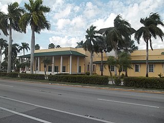
Hallandale Beach is a city in southern Broward County, Florida, United States. The city is named after Luther Halland, the son of a Swedish worker for Henry Flagler's Florida East Coast Railroad. It is also part of the Miami metropolitan area of South Florida. As of the 2020 census, the population was 41,217.

<span class="mw-page-title-main">Flagler Beach, Florida</span> City in Florida, United States

Flagler Beach is a city in Flagler County in the U.S. state of Florida. The population was 5,160 at the 2020 census.

<span class="mw-page-title-main">Hobe Sound, Florida</span> Census-designated place in Florida, United States

Hobe Sound is an unincorporated area and census-designated place (CDP) in Martin County, Florida, United States, located along Florida's Treasure Coast. The population was 13,163 at the 2020 census, up from 11,521 in 2010.

<span class="mw-page-title-main">Aventura, Florida</span> City in Florida

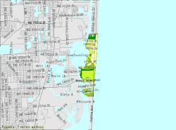
Aventura is a planned suburban city in northeastern Miami-Dade County, Florida, United States, 15 miles (24 km) north of Miami and part of the Miami metropolitan area of South Florida. The city is especially known for Aventura Mall, the third largest mall in the United States by total square feet of retail space and the largest mall in Florida.

<span class="mw-page-title-main">Bal Harbour, Florida</span> Village in Florida

Bal Harbour is a village in Miami-Dade County, Florida. The village is part of the Miami metropolitan area of South Florida. The population was 3,093 at the 2020 US Census.
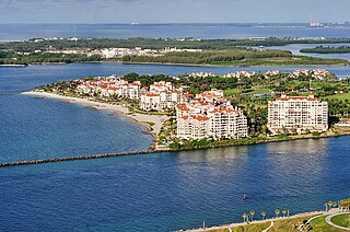
<span class="mw-page-title-main">Golden Beach, Florida</span> Town in Florida

Golden Beach is a town in Miami-Dade County, Florida, United States, between the Intracoastal Waterway and Atlantic Ocean. The town is part of the Miami metropolitan area of South Florida. As of the 2020 US census, the town had a population of 961.

<span class="mw-page-title-main">North Miami, Florida</span> City in Florida

North Miami is a suburban city located in northeast Miami-Dade County, Florida, United States, about 10 miles (16 km) north of Miami. The city lies on Biscayne Bay and hosts the Biscayne Bay Campus of Florida International University.. Originally the "Town of Arch Creek", the area was incorporated as the "Town of Miami Shores", which was renamed the "Town of North Miami" in 1931. It was reincorporated as a city in 1953. The city is part of the Miami metropolitan area of South Florida.

<span class="mw-page-title-main">North Miami Beach, Florida</span> City in Florida

North Miami Beach is a city in Miami-Dade County, Florida, United States. The city is part of the Miami metropolitan area of South Florida. Originally named "Fulford-by-the-Sea" in 1926 after Captain William H. Fulford of the U.S. Coast Guard, the city was renamed "North Miami Beach" in 1931. The population was 43,676 at the 2020 US census.

<span class="mw-page-title-main">Ojus, Florida</span> Census-designated place in Florida

Ojus is a census-designated place and formerly incorporated town in Miami-Dade County, Florida, United States. It is part of the Miami metropolitan area of South Florida. The population was 19,673 at the 2020 census, up from 18,036 in 2010.

<span class="mw-page-title-main">Juno Beach, Florida</span> Town in the state of Florida, United States

Juno Beach is a town in Palm Beach County, Florida, United States. Juno Beach is home to the headquarters of Florida Power & Light, the Loggerhead Marinelife Center and the Seminole Golf Club. It was also the original county seat for the area that was then known as Dade County. Juno Beach is in the Miami metropolitan area. The political climate in Juno Beach is leaning liberal. The property crime rate is around the US national average, with the violent crime rate well below average. The Town of Juno Beach was officially incorporated in 1953. As of 2020, the town's population recorded by the U.S. Census Bureau was 3,858.
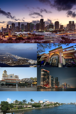
<span class="mw-page-title-main">Palm Valley, Florida</span> CDP in Florida, United States

Palm Valley is a census-designated place (CDP) in St. Johns County, Florida, United States. The population was 19,860 at the 2000 census.

<span class="mw-page-title-main">Daytona Beach Shores, Florida</span> City in Florida, United States

Daytona Beach Shores is a city in Volusia County, Florida, United States. The population was 5,179 at the 2020 census.

<span class="mw-page-title-main">Miami metropolitan area</span> Metropolis in the U.S. state of Florida

The Miami metropolitan area, also known as South Florida, SoFlo, SoFla, the Gold Coast, the Tri-County Area, or Greater Miami, and officially the Miami–Fort Lauderdale–West Palm Beach Metropolitan Statistical Area, is a coastal metropolitan area in southeastern Florida. It is the ninth-largest metropolitan statistical area (MSA) in the United States, the fifth-largest metropolitan area in the Southern United States, and the largest metropolitan area in Florida. With a population of 6.18 million, its population exceeds 31 of the nation's 50 states as of 2023. It comprises the three most populated counties in the state, Miami-Dade County, Broward County, and Palm Beach County, which rank as the first, second, and third-most populous counties in the state, respectively. Miami-Dade County, with 2,701,767 people in 2020, is the seventh-most populous county in the United States.

<span class="mw-page-title-main">Florida State Road 826</span> Highway in Florida

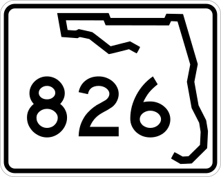
State Road 826 is a bypass route around the greater Miami area, traveling approximately 30 miles (48 km) in a northeasterly arc from U.S. Route 1 in Pinecrest to its terminus at State Road A1A in Sunny Isles Beach. Between its southern terminus and the Golden Glades Interchange, State Road 826 is known as the Palmetto Expressway, a heavily traveled freeway with portions of the road carrying in excess of 250,000 vehicles a day. Unlike many of the other non-interstate freeways in Miami-Dade County, the Palmetto Expressway is untolled. East of the interchange, State Road 826 is a surface road connecting North Miami and North Miami Beach to Sunny Isles Beach over the Intracoastal Waterway.

<span class="mw-page-title-main">Baker's Haulover Inlet</span> Ocean inlet in Florida, US

Baker's Haulover Inlet, more commonly known simply as Haulover inlet, is a man-made channel in Miami-Dade County, Florida connecting the northern end of Biscayne Bay with the Atlantic Ocean. The inlet was cut in 1925 through a narrow point in the sand between the cities of Bal Harbour and Sunny Isles. It is the location of an official nude beach, recreation areas and marina in the 99-acre Haulover Park. A fixed bridge carries State Road A1A across the inlet.

<span class="mw-page-title-main">Florida State Road 856</span> Highway in Florida

State Road 856 (SR 856), also known as the William Lehman Causeway, is a 1.704-mile-long (2.742 km) causeway connecting Biscayne Boulevard in Aventura and Collins Avenue (SR A1A) in Sunny Isles Beach, Florida.

<span class="mw-page-title-main">U.S. Route 1 in Florida</span> Highway in Florida

U.S. Highway 1 (US 1) in Florida runs 545 miles (877 km) along the state's east coast from Key West to its crossing of the St. Marys River into Georgia north of Boulogne and south of Folkston. US 1 was designated through Florida when the U.S. Numbered Highway System was established in 1926. With the exception of Monroe County, the highway runs through the easternmost tier of counties in the state, connecting numerous towns and cities along its route, including nine county seats. The road is maintained by the Florida Department of Transportation (FDOT).

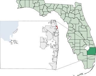
Eastern Shores is a neighborhood within the city of North Miami Beach in Miami-Dade County, Florida, United States. It is located about 12 miles (19 km) north of Miami, just south of the city of Aventura.

<span class="mw-page-title-main">Miami-Dade County, Florida</span> County in Florida, United States

Miami-Dade County is a county located in the southeastern part of the U.S. state of Florida. The county had a population of 2,701,767 as of the 2020 census, making it the most populous county in Florida and the seventh-most populous county in the United States. It is Florida's third largest county in terms of land area with 1,946 square miles (5,040 km2). The county seat is Miami, the core of the nation's ninth-largest and world's 65th-largest metropolitan area with a 2020 population of 6.138 million people, exceeding the population of 31 of the nation's 50 states as of 2022.

References

  1. "Mayor - City of Sunny Isles Beach".
  2. 1 2 "2022 U.S. Gazetteer Files: Florida". United States Census Bureau. Retrieved December 28, 2022.
  3. 1 2 "P1. Race – Sunny Isles Beach city, Florida: 2020 DEC Redistricting Data (PL 94-171)". U.S. Census Bureau. Retrieved December 28, 2022.
  4. "U.S. Census website". United States Census Bureau . Retrieved January 31, 2008.
  5. "Sunny Isles- Boom or Bust: Miami". Bobmiami.com. Archived from the original on November 3, 2013. Retrieved July 16, 2013.
  6. "Spring Break 2008". MTV. Retrieved July 17, 2013.
  7. 1 2 3 http://www.sibfl.net/wp-content/uploads/2013/05/Adopted_Budget_10-11.pdf [ bare URL PDF ]
  8. "Our History - City of North Miami Beach, Florida". Citynmb.com. Archived from the original on May 17, 2013. Retrieved July 20, 2013.
  9. "Buys Sunny Isles Development" Wall Street Journal Dec. 14, 1936
  10. Cantor, Judy (August 3, 1995). "Kitsch Highway - Page 1 - Arts - Miami". Miami New Times. Retrieved July 20, 2013.
  11. Nevins, Buddy (July 20, 1986). "Restored Sunny Isles Pier Opens". Sun Sentinel. Retrieved July 16, 2013.
  12. Bock, Daniel (June 21, 2013). "SIB celebrates reopening of Newport Fishing Pier - Aventura / Sunny Isles". MiamiHerald.com. Retrieved July 16, 2013.
  13. "Voters To Pick City's Name". Sun Sentinel. September 3, 1998. Retrieved July 16, 2013.
  14. "The Mansions at Acqualina Acqualina". Acqualinamiami.com. Retrieved July 16, 2013.
  15. "US Gazetteer files: 2010, 2000, and 1990". United States Census Bureau. February 12, 2011. Retrieved April 23, 2011.
  16. "Decennial Census of Population and Housing by Decades". US Census Bureau.
  17. "Explore Census Data". data.census.gov. Retrieved February 8, 2022.
  18. "S1101 HOUSEHOLDS AND FAMILIES - 2020: Sunny Isles Beach city, Florida". United States Census Bureau .
  19. "S1101 HOUSEHOLDS AND FAMILIES - 2010: Sunny Isles Beach city, Florida". United States Census Bureau .
  20. "MLA's Data Center Results of Sunny Isles Beach, FL". Modern Language Association . Retrieved October 27, 2007.
  21. "Sunny Isles Beach, FL Detailed Map". city-data.com. Retrieved January 11, 2015.
  22. 1 2 "NORMAN S. EDELCUP/SUNNY ISLES BEACH K-8 Boundary Description". Miami-Dade County Public Schools . Retrieved June 28, 2021.
  23. 1 2 Boyd-Barret, Claudia (February 4, 2007). "K-8 center will ease overcrowding at schools". The Miami Herald . pp. 8, 46. - Clipping of first and of second page from Newspapers.com.
  24. Amerikaner, Andres (February 10, 2008). "Word of new school greeted with zeal". Miami Herald . p. 36. - Clipping from Newspapers.com.
  25. Duque, Pamela (February 17, 2011). "City's public school may be renamed". Miami Herald . p. 6NE. - Clipping from Newspapers.com.
  26. "HIGHLAND OAKS MS Boundary Description". Miami-Dade County Public Schools . Retrieved June 28, 2021.
  27. "ALONZO AND TRACY MOURNING SENIOR HIGH BISCAYNE BAY Boundary Description". Miami-Dade County Public Schools . 2009–2010. Retrieved June 28, 2021.
  28. "Educational Facilities". City of Sunny Isles Beach. 2021. Retrieved April 1, 2024.
  29. "Netanya - Twin Cities". Netanya Municipality. Archived from the original on February 1, 2013. Retrieved August 1, 2013.
  30. "Taormina, Italy".
  31. "Punta del Este, Uruguay".
  32. "Hengchun, Taiwan".