Homestead, Florida

Last updated

Homestead, Florida
Downtown Homestead street clock.jpg
Flag of Homestead, Florida.png
Seal of Homestead, Florida.png
Motto: 
"Gateway to Everglades & Biscayne National Parks" & "Discover the Opportunities"
Miami-Dade County Florida Incorporated and Unincorporated areas Homestead Highlighted.svg
Location in Miami-Dade County and the U.S. state of Florida
Homestead.gif
U.S. Census Bureau map showing city limits
Coordinates: 25°28′07″N80°28′39″W / 25.4687224°N 80.4775569°W / 25.4687224; -80.4775569
Country Flag of the United States.svg  United States of America
State Flag of Florida.svg  Florida
County Flag of Miami-Dade County, Florida.png Miami-Dade
Incorporated February 8, 1913
Government
  Type Council-Manager
   Mayor Steven D. Losner
   Vice Mayor Sean L. Fletcher
   Councilmembers
  • Erica G. Ávila
  • Jenifer N. Bailey
  • Clemente Canabal
  • Thomas B. Davis
  • Larry Roth
   City Manager Jerry Estrada
   City Clerk Elizabeth Sewell
Area
[1]
  Total15.58 sq mi (40.36 km2)
  Land15.08 sq mi (39.07 km2)
  Water0.50 sq mi (1.29 km2)  0.63%
Elevation
[2]
3 ft (1 m)
Population
 (2020)
  Total80,737
  Density5,352.49/sq mi (2,066.63/km2)
Time zone UTC−5 (Eastern (EST))
  Summer (DST) UTC−4 (EDT)
ZIP Codes
33030–33035, 33039, 33090, 33092
Area code(s) 305, 786, 645
FIPS code 12-32275 [3]
GNIS feature ID0284214 [2]
Website www.CityOfHomestead.com

Homestead is a city within Miami-Dade County in the U.S. state of Florida, between Biscayne National Park to the east and Everglades National Park to the west. Homestead is primarily a Miami suburb and a major agricultural area. It is a principal city of the Miami metropolitan area of South Florida, which was home to an estimated 6,012,331 people at the 2015 census. It is located approximately 26 miles (42 km) southwest of Miami, and 25 miles (40 km) northwest of Key Largo. The population was 80,737 as of the 2020 census.

Contents

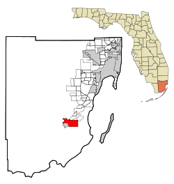
The city of Homestead is located near the southern terminus of the Homestead Extension of Florida's Turnpike where it ends at its junction with U.S. 1. Homestead is immediately north and east of Florida City, and these two cities comprise the greater Homestead–Florida City area. Some of the notable unincorporated communities in the area are Redland, Leisure City, Naranja, and Princeton.

History

Homestead was incorporated in 1913 and is the second oldest city in Miami-Dade County next to the city of Miami. The name originates from when the Florida East Coast Railway extension to Key West was being built. The rail line was passing through an area opened up for homesteading, and as the construction camp at the end of the line did not have a particular name, construction materials and supplies for the workers were consigned to "Homestead Country", shortened to "Homestead" by the engineers who mapped the area. [4]

Homestead and neighboring South Miami-Dade County communities bore the brunt of Category 5 Hurricane Andrew on August 24, 1992.

Geography

According to the United States Census Bureau, the city has a total area of 14.4 square miles (37 km2). 14.3 square miles (37 km2) of it is land and 0.1 square miles (0.26 km2) of it (0.63%) is water.

Homestead is a small-sized city. At its greatest north–south points – along SW 137th Avenue (Speedway Boulevard) – its city limits extend only 4 miles (6 km) – from SW 288th Street (Biscayne Drive) at the north end to (theoretical) SW 352nd Street at the south end. At its greatest east–west points – along SW 328th Street (North Canal Drive / Lucy Street) – its city limits extend 6 miles (10 km) – from (theoretical) SW 132nd Avenue at the east end to SW 192nd Avenue at the west end. U.S. 1 – known as Homestead Boulevard within the city limits – extends through a rather narrow northeast / southwest corridor of the city from SW 304th Street (Kings Highway) at the north end to SW 328th Street (Lucy Street) at the south end. It is at this point at the south end that Homestead and Florida City share a common border. (North of the north end at SW 304th Street is known as Unincorporated Miami-Dade County, but it is locally known as the community of Leisure City).

Major east–west streets within Homestead include SW 304th Street / NE & NW 15th Street (Kings Highway), SW 312th Street / NE & NW 8th Street (Campbell Drive), SW 320th Street (Mowry Drive), SW 328th Street / SE & SW 8th Street (North Canal Drive / Lucy Street), and SW 344th Street / SE 24th Street (Palm Drive).

The original Homestead Air Force Base was once located several miles to the northeast of Homestead, but due to annexation of formerly unincorporated land immediately to the east and northeast of the original city limits during the late-1990s the city and the far southwestern perimeter of the (now) Homestead Air Reserve Base share a common border for a small portion along SW 137th Avenue (Speedway Boulevard).

A noteworthy tourist attraction within Leisure City is Coral Castle, built by a jilted lover, Edward Leedskalnin, over the course of 28 years from 1923 to 1951. [5] The Fruit and Spice Park is also of interest.

Climate

Homestead experiences a tropical monsoon climate (Köppen climate classification Am) that borders on a tropical savanna climate (Aw). Summers are hot and humid and high temperatures average between 90° and 92 °F (32° to 33 °C). Winters are warm and dry. The all-time record high temperature is 100 °F (37.8 °C), on July 10, 2023, and August 11, 2023. Lows in summer average between 70 °F (21.1 °C) and 75 °F (23.9 °C), with low temperatures in all times of year averaging 5 degrees cooler than coastal Miami, mainly because of its inland and rural location. In winter, the area sees cold fronts bring cold weather for short periods from November to March. The lowest temperature ever recorded is 26 °F (–3 °C), on 13 December 1934, which was recorded at Homestead Air Force Base, some 10 miles east of the town. High temperatures in winter average between 68° and 80 °F (18° to 26 °C), and lows average between 57° and 64 °F (8° to 14 °C). [6] Summer is the season when most of the rain occurs. Homestead has a wet season lasting from mid-May to early October. The dry season sees some rain, with most of it coming with the passing of cold fronts. Snow flurries were reported to have been observed in the air at Homestead Air Force Base, on January 20, 1977, and marked the farthest south that snow flurries have ever been reported in the lower 48 United States.

Climate data for Homestead, Florida (Miami Homestead General Aviation Airport), 1991–2020 normals, extremes 1990present
MonthJanFebMarAprMayJunJulAugSepOctNovDecYear
Record high °F (°C)89
(32)
91
(33)
93
(34)
97
(36)
99
(37)
99
(37)
100
(38)
100
(38)
98
(37)
99
(37)
91
(33)
90
(32)
99
(37)
Mean maximum °F (°C)85.0
(29.4)
86.7
(30.4)
89.0
(31.7)
91.4
(33.0)
93.4
(34.1)
94.7
(34.8)
95.5
(35.3)
95.7
(35.4)
94.0
(34.4)
92.3
(33.5)
87.5
(30.8)
85.3
(29.6)
96.5
(35.8)
Mean daily maximum °F (°C)77.5
(25.3)
79.5
(26.4)
81.8
(27.7)
85.5
(29.7)
88.4
(31.3)
90.8
(32.7)
92.0
(33.3)
92.1
(33.4)
91.0
(32.8)
87.5
(30.8)
82.5
(28.1)
79.2
(26.2)
85.6
(29.8)
Daily mean °F (°C)66.4
(19.1)
68.0
(20.0)
70.4
(21.3)
74.3
(23.5)
78.2
(25.7)
81.7
(27.6)
82.9
(28.3)
83.2
(28.4)
82.4
(28.0)
78.9
(26.1)
73.0
(22.8)
69.0
(20.6)
75.7
(24.3)
Mean daily minimum °F (°C)55.3
(12.9)
56.6
(13.7)
59.0
(15.0)
63.2
(17.3)
68.1
(20.1)
72.7
(22.6)
73.8
(23.2)
74.3
(23.5)
73.9
(23.3)
70.4
(21.3)
63.4
(17.4)
58.7
(14.8)
65.8
(18.8)
Mean minimum °F (°C)39.6
(4.2)
42.7
(5.9)
46.5
(8.1)
52.1
(11.2)
60.9
(16.1)
69.0
(20.6)
70.7
(21.5)
71.3
(21.8)
70.5
(21.4)
60.5
(15.8)
51.4
(10.8)
45.0
(7.2)
37.4
(3.0)
Record low °F (°C)30
(−1)
33
(1)
36
(2)
45
(7)
51
(11)
63
(17)
64
(18)
67
(19)
67
(19)
45
(7)
39
(4)
31
(−1)
30
(−1)
Average precipitation inches (mm)1.70
(43)
2.01
(51)
2.05
(52)
2.92
(74)
5.77
(147)
9.34
(237)
7.14
(181)
10.17
(258)
8.63
(219)
5.86
(149)
2.34
(59)
1.97
(50)
59.90
(1,521)
Average precipitation days (≥ 0.01 in)7.16.65.96.211.418.117.218.818.512.48.08.7138.9
Source: NOAA [7] [8]

Hurricanes

In August 1992, the Category 5 hurricane Andrew devastated the town, as well as nearby Homestead Air Force Base. Hurricane Katrina caused flooding in Homestead in August 2005. [9] The following October, Hurricane Wilma damaged light poles, grandstands, garages, and sections of catch fence at the Homestead–Miami Speedway, a motor racetrack built in the years following Hurricane Andrew. [10] After Hurricane Wilma, a Homestead man was killed in a tractor accident while clearing debris. [11]

When Hurricane Irma struck Florida in September 2017, parts of Homestead lost electric power. South Dade Center, a low-income housing project for farmworkers, was flooded with rainwater. Residents were without electricity and waste collection for about a week without relief. [12]

Demographics

Historical population
CensusPop.Note
1920 1,307
1930 2,31977.4%
1940 3,15436.0%
1950 4,57345.0%
1960 9,152100.1%
1970 13,67449.4%
1980 20,66851.1%
1990 26,86630.0%
2000 31,90918.8%
2010 60,51289.6%
2020 80,73733.4%
U.S. Decennial Census [13]
Historical demographics2020 [14] 2010 [15] 2000 [16] 1990 [17] 1980 [18]
White (non-Hispanic)10.9%16.0%22.9%41.8%57.7%
Hispanic or Latino 68.2%62.9%51.8%35.3%16.0%
Black or African American (non-Hispanic)17.3%18.4%21.6%22.0%24.9%
Asian and Pacific Islander (non-Hispanic)1.1%1.2%0.8%0.7%1.3%
Native American (non-Hispanic)0.1%0.1%0.2%0.2%
Some other race (non-Hispanic)0.6%0.2%0.1%0.1%
Two or more races (non-Hispanic)1.8%1.1%2.6%N/AN/A
Population80,73760,51231,90926,86620,688

2010 and 2020 census

Homestead racial composition
(Hispanics excluded from racial categories)
(NH = Non-Hispanic)
RacePop 2010 [19] Pop 2020 [20] % 2010% 2020
White (NH)9,6848,76816.00%10.86%
Black or African American (NH)11,13214,00618.40%17.35%
Native American or Alaska Native (NH)77650.13%0.08%
Asian (NH)6848771.13%1.09%
Pacific Islander or Native Hawaiian (NH)64390.11%0.05%
Some other race (NH)1364950.22%0.61%
Two or more races/Multiracial (NH)6571,4361.09%1.78%
Hispanic or Latino (any race)38,07855,05162.93%68.19%
Total60,51280,737

As of the 2020 United States census, there were 80,737 people, 19,392 households, and 15,601 families residing in the city. [21]

As of the 2010 United States census, there were 60,512 people, 17,397 households, and 12,278 families residing in the city. [22]

Media

The city of Homestead is served by the Miami market for local radio and television. Homestead has its own newspaper, the South Dade News Leader, which has been serving the South Dade community since 1913. The News Leader is published on Fridays.

"Inside Homestead TV" is a television program where viewers can find out about all the happenings in Homestead. Each month, a news show is released offering Homestead residents updates on local events as well as other developments throughout the region. Also, the program has in-depth interviews with the local Mayor & Council and City Staff, special events coverage, and how-to videos.

These monthly news reports vary in topic every month. For instance, the March 2015 video describes the new City Hall, education and National Parks news. [23]

Government and infrastructure

The Florida Department of Corrections operates the Dade Correctional Institution and the Homestead Correctional Institution in an unincorporated area near Homestead. [24] [25] [26] The Dade CI was originally the Dade Correctional Institution Annex, and the Homestead CI was originally the Dade Correctional Institution; the two received their current names on July 1, 2003. [27] In June 2018, Homestead Temporary Shelter for Unaccompanied Children, a federal facility operated by Comprehensive Health Services, Inc., was estimated to hold 1,000 minor detainees. [28]

The United States Postal Service operates the Homestead Post Office. [29]

The Homestead Police Department located at 45 Northwest First Avenue in Homestead.

On October 11, 1957, an Air Force B-47 Stratojet carrying a nuclear bomb crashed on takeoff at Homestead Air Force Base, present-day Homestead Air Reserve Base. [30]

Transportation

The principal roadways linking Homestead with the rest of Miami-Dade County are US 1, the Florida Turnpike and State Road 997. The Florida Turnpike has three exits (6, 5 and 2) as it runs south through eastern Homestead before eventually terminating at US 1 in Florida City. US 1 (Homestead Blvd.) runs northeast-to-southwest roughly through the middle of the city, and is the only way to continue to the Florida Keys. State Road 997 (Krome Ave.) runs north–south through the western end of Homestead and through the historic downtown district.

Miami-Dade Transit (MDT) runs several Metrobus routes connecting the Homestead/Florida City area to the rest of Miami-Dade County. Express routes run along the South Miami-Dade Busway, connecting the area with Metrorail and the rest of the Metrobus network and on to Tri-Rail, Amtrak and Miami International Airport. In addition, MDT operates Dade-Monroe Express service from Florida City to the Upper Keys.

The City of Homestead operates two local circulator lines. [31] This free service operates daily and transits principal residential, business and commercial areas, as well as the historic downtown district and Miami-Dade College's Homestead Campus. The Trolley connects with Metrobus at the Busway and other Metrobus stops throughout the city. [32]

Starting in 2014 the Homestead Trolley began seasonal service to Everglades National Park and Biscayne National Park. The free Homestead National Parks Trolley [33] ] is offered by the City of Homestead in partnership with the National Park Service. Operating on weekends between January and April, the service is the only public transportation option available to these two parks. [34] [35] [36] [37]

The Homestead General Aviation Airport is located just northwest of the city's central business district.

There are public marinas at Homestead Bayfront Park and Marina, on Biscayne Bay east of the city and adjacent to Biscayne National Park's Convoy Point Visitor Center, and at Black Point Park and Marina to the northeast. Convoy Point also has a limited number of marina slips for day visitors to dock.

Most major national car and truck rental companies have rental locations in Homestead or its immediate surroundings.

Points of interest

Seminole Theatre in downtown Homestead Seminole Theatre.jpg
Seminole Theatre in downtown Homestead

Notable people

Education

Public schools

Homestead is within the Miami-Dade County Public Schools district.

Homestead and the region are zoned to the following elementary, middle and K–8 center schools:

Most of Homestead is zoned to Homestead High School, while a northwest portion is zoned to South Dade High School, located outside the city limits in unincorporated Miami-Dade County.

Homestead is zoned to South Dade Educational Center.[ which? ]

Charter schools

Homestead also has the following charter schools:

Private schools

The Roman Catholic Archdiocese of Miami previously operated Sacred Heart School in Homestead. [41] It closed in 2009. [42]

Colleges and universities

Homestead is also home to Miami-Dade College Homestead Campus.

Parks and recreation

Related Research Articles

<span class="mw-page-title-main">Miami</span> City in Florida

Miami, officially the City of Miami, is a coastal metropolis in the U.S. state of Florida and the seat of Miami-Dade County in South Florida. It is the core of the much larger Miami metropolitan area, which, with a population of 6.14 million, is the second-largest metropolitan area in the Southeast after Atlanta, and the ninth-largest in the United States. With a population of 442,241 within its city limits as of the 2020 census, Miami is the second-most populous city proper in Florida after Jacksonville. Miami has the third-largest skyline in the U.S. with over 300 high-rises, 58 of which exceed 491 ft (150 m).

<span class="mw-page-title-main">Broward County, Florida</span> County in Florida, United States

Broward County is a county in the southeastern part of Florida, located in the Miami metropolitan area. It is Florida's second-most populous county after Miami-Dade County and the 17th-most populous in the United States, with 1,944,375 residents as of the 2020 census. Its county seat and most populous city is Fort Lauderdale, which had a population of 182,760 as of 2020.

<span class="mw-page-title-main">Pembroke Pines, Florida</span> City in Broward County, Florida, United States

Pembroke Pines is a city in southern Broward County, Florida, United States. The city is located 22 miles (35 km) north of Miami. It is a suburb of and the fourth-most populous city in the Miami metropolitan area. The population of Pembroke Pines was 171,178 at the 2020 census.

<span class="mw-page-title-main">Cutler Bay, Florida</span> Town in the state of Florida, United States

Cutler Bay is an incorporated town in Miami-Dade County, Florida, United States, established in 2005. With a population of 45,425 as of the 2020 US census, it is part of the Miami metropolitan area of South Florida. Cutler Bay is the 9th most populous of the 34 municipalities that make up Miami's urban core, and the 33rd most populous of the 163 municipalities.

<span class="mw-page-title-main">Doral, Florida</span> City in Florida

Doral is a city in Miami-Dade County, Florida, United States. One of 34 municipalities in the county, it is located 5 miles (8 km) west of Miami International Airport and 13 miles (21 km) west of Downtown Miami. Doral occupies 15 square miles (39 km2) bordered on the west by the Ronald Reagan Turnpike and the Florida Everglades, on the north by the town of Medley, on the east by the Palmetto Expressway and on the south by the Dolphin Expressway and the city of Sweetwater. The city is part of the Miami metropolitan area of South Florida. As of the 2020 census, Doral had a population of 75,874, up from 45,704 in 2010.

<span class="mw-page-title-main">Florida City, Florida</span> City in Florida

Florida City is a city in Miami-Dade County, Florida, United States. It is the southernmost municipality in the South Florida metropolitan area. Florida City is primarily a Miami suburb and a major agricultural area. As of the 2020 census, it had a population of 13,085, up from 11,245 in 2010.

<span class="mw-page-title-main">Gladeview, Florida</span> Census-designated place in Florida

Gladeview is a census-designated place (CDP) in Miami-Dade County, Florida, United States. It is part of the Miami metropolitan area of South Florida. The population was 14,927 at the 2020 census, up from 11,535 in 2010.

<span class="mw-page-title-main">Hialeah, Florida</span> City in Florida

Hialeah is a city in Miami-Dade County, Florida, United States. With a population of 223,109 as of the 2020 census, Hialeah is the sixth-largest city in Florida. It is the second largest city by population in the Miami metropolitan area of South Florida, which was home to an estimated 6,198,782 people at the 2018 census. It is located west-northwest of Miami, and is one of a few places in the county—others being Homestead, Miami Beach, Surfside, Bal Harbour, Sunny Isles Beach, and Golden Beach—to have its own street grid numbered separately from the rest of the county.

<span class="mw-page-title-main">Kendale Lakes, Florida</span> Census-designated place in Florida

Kendale Lakes is a census-designated place (CDP) and a suburb of Miami in Miami-Dade County, Florida, United States. It is located in the Miami metropolitan area of South Florida. The population was 55,646 at the 2020 census.

<span class="mw-page-title-main">Kendall, Florida</span> Census-designated place in Florida

Kendall is an unincorporated area and census-designated place in Miami-Dade County, Florida. It is part of the Miami metropolitan area of South Florida. At the 2020 census, the area had a population of 80,241.

<span class="mw-page-title-main">Leisure City, Florida</span> Census-designated place in Florida

Leisure City is an unincorporated community and census-designated place (CDP) in Miami-Dade County, Florida, United States, that includes the smaller, older community of Modello in its northwestern section. The CDP is most notable for the Coral Castle Museum, located in the Modello area. It is located in the Miami metropolitan area of South Florida. The population was 26,324 at the 2020 census, up from 22,655 in 2010.

<span class="mw-page-title-main">Naranja, Florida</span> Census-designated place in Florida

Naranja is an unincorporated community and census-designated place (CDP) in Miami-Dade County, Florida, United States. Many orange groves were once located in this area, so the community name came from the Spanish word for orange, naranja, though the pronunciation among the local residents is "Na-Ran-Jah". Naranja was also a stop for the Florida East Coast Railroad that once ran through this area. It is part of the Miami metropolitan area of South Florida. The population was 13,509 at the 2020 census, up from 8,303 in 2010.

<span class="mw-page-title-main">North Miami, Florida</span> City in Florida

North Miami is a suburban city located in northeast Miami-Dade County, Florida, United States, about 10 miles (16 km) north of Miami. The city lies on Biscayne Bay and hosts the Biscayne Bay Campus of Florida International University.. Originally the "Town of Arch Creek", the area was incorporated as the "Town of Miami Shores", which was renamed the "Town of North Miami" in 1931. It was reincorporated as a city in 1953. The city is part of the Miami metropolitan area of South Florida.

<span class="mw-page-title-main">Olympia Heights, Florida</span> Census-designated place in Florida

Olympia Heights is a census-designated place in Miami-Dade County, Florida, United States. It is located in the Miami metropolitan area of South Florida. The population was 12,873 at the 2020 census.

<span class="mw-page-title-main">Richmond West, Florida</span> Census-designated place in Florida

Richmond West is a census-designated place (CDP) in Miami-Dade County, Florida, United States. It is part of the Miami metropolitan area of South Florida. The population was 35,884 at the 2020 census, up from 31,973 at the 2010 census.

<span class="mw-page-title-main">Tamiami, Florida</span> Census-designated place in Florida

Tamiami is a census-designated place (CDP) in Miami-Dade County, Florida, United States. It is part of the Miami metropolitan area of South Florida. The population was 54,212 at the 2020 census.

<span class="mw-page-title-main">Westchester, Florida</span> Census-designated place in Florida

Westchester is a census-designated place (CDP) and neighborhood in Miami-Dade County, Florida. It is part of the Miami metropolitan area of South Florida. Prior to the 2020 U.S. Census, the neighboring University Park CDP was merged into Westchester CDP, effectively doubling its geography and population. Per the 2020 census, the population was 56,384.

<span class="mw-page-title-main">Miami metropolitan area</span> Metropolis in the U.S. state of Florida

The Miami metropolitan area, also known as South Florida, SoFlo, SoFla, the Gold Coast, the Tri-County Area, or Greater Miami, and officially the Miami–Fort Lauderdale–West Palm Beach Metropolitan Statistical Area, is a coastal metropolitan area in southeastern Florida. It is the ninth-largest metropolitan statistical area (MSA) in the United States, the fifth-largest metropolitan area in the Southern United States, and the largest metropolitan area in Florida. With a population of 6.18 million, its population exceeds 31 of the nation's 50 states as of 2023. It comprises the three most populated counties in the state, Miami-Dade County, Broward County, and Palm Beach County, which rank as the first, second, and third-most populous counties in the state, respectively. Miami-Dade County, with 2,701,767 people in 2020, is the seventh-most populous county in the United States.

<span class="mw-page-title-main">Redland, Florida</span> Unincorporated community in Florida, United States

Redland, long known also as the Redlands or the Redland, is a historic unincorporated community and agricultural area in Miami-Dade County, Florida, located about 20 miles (32 km) southwest of downtown Miami and just northwest of Homestead, Florida. It is unique in that it constitutes a large farming belt directly adjoining what is now the seventh most populous major metropolitan area in the United States. Named for the pockets of red clay that cover a layer of oolitic limestone, Redland produces a variety of tropical fruits, many of which do not grow elsewhere in the continental United States. The area also contains a large concentration of ornamental nurseries. The landscape is dotted with u-pick'em fields, coral rock (oolite) walls, and the original clapboard homes of early settlers and other historic early twentieth century structures.

<span class="mw-page-title-main">Miami-Dade County, Florida</span> County in Florida, United States

Miami-Dade County is a county located in the southeastern part of the U.S. state of Florida. The county had a population of 2,701,767 as of the 2020 census, making it the most populous county in Florida and the seventh-most populous county in the United States. It is Florida's third largest county in terms of land area with 1,946 square miles (5,040 km2). The county seat is Miami, the core of the nation's ninth-largest and world's 65th-largest metropolitan area with a 2020 population of 6.138 million people, exceeding the population of 31 of the nation's 50 states as of 2022.

References

  1. "2020 U.S. Gazetteer Files". United States Census Bureau. Retrieved October 31, 2021.
  2. 1 2 U.S. Geological Survey Geographic Names Information System: Homestead, Florida
  3. "U.S. Census website". United States Census Bureau . Retrieved January 31, 2008.
  4. Taylor, Jean (1985). Villages of South Dade. St. Petersburg, Fla: B. Kennedy. p. 157. LCCN   88132899. OCLC   18906834.
  5. "F A Q". coralcastle.com. Archived from the original on July 23, 2005. Retrieved March 20, 2018.
  6. Weather History for Homestead retrieved August 6, 2006
  7. "NOWData – NOAA Online Weather Data". National Oceanic and Atmospheric Administration . Retrieved May 9, 2021.
  8. "Summary of Monthly Normals 1991–2020". National Oceanic and Atmospheric Administration . Retrieved May 9, 2021.
  9. Kaye, Ken (August 25, 2015). "Hurricane Katrina hit South Florida 10 years ago today". Sun-Sentinel . Retrieved July 27, 2018.
  10. Clark, Cammy (October 25, 2005). "Auto track damaged by Wilma". Chicago Tribune . Retrieved July 27, 2018.
  11. Yanez, Luisa (November 8, 2005). "Dade Hit Hardest as Death Toll Reaches 31 Across the State". Miami Herald . pp. 1B.
  12. Iannelli, Jerry (September 15, 2017). "Homestead Migrant Farm Workers Neglected After Irma Until Activists Raise Alarm". Miami New Times . Archived from the original on October 31, 2017. Retrieved December 2, 2017.
  13. "Census of Population and Housing". Census.gov. Retrieved June 4, 2015.
  14. "P2: HISPANIC OR LATINO, AND NOT ... - Census Bureau Table". P2 | HISPANIC OR LATINO, AND NOT HISPANIC OR LATINO BY RACE. U.S. Census Bureau. Retrieved March 20, 2023.
  15. "P2: HISPANIC OR LATINO, AND NOT ... - Census Bureau Table". P2 | HISPANIC OR LATINO, AND NOT HISPANIC OR LATINO BY RACE. U.S. Census Bureau. Retrieved March 20, 2023.
  16. "PL002: HISPANIC OR LATINO, AND NOT ... - Census Bureau Table". PL002 | HISPANIC OR LATINO, AND NOT HISPANIC OR LATINO BY RACE [73]. U.S. Census Bureau. Retrieved March 20, 2023.
  17. "1990 Census of Population General Population Characteristics Florida Section 1 of 2" (PDF). Florida: 1990, Part 1. U.S. Census Bureau. Retrieved March 20, 2023.
  18. "General Population Characteristics FLORIDA 1980 Census of Population" (PDF). 07553445v1chA-Cpt11sec1ch002.pdf. U.S. Census Bureau. Retrieved March 20, 2023.
  19. "P2 HISPANIC OR LATINO, AND NOT HISPANIC OR LATINO BY RACE - 2010: DEC Redistricting Data (PL 94-171) - Homestead city, Florida". United States Census Bureau .
  20. "P2 HISPANIC OR LATINO, AND NOT HISPANIC OR LATINO BY RACE - 2020: DEC Redistricting Data (PL 94-171) - Homestead city, Florida". United States Census Bureau .
  21. "S1101 HOUSEHOLDS AND FAMILIES - 2020: Homestead city, Florida". United States Census Bureau .
  22. "S1101 HOUSEHOLDS AND FAMILIES - 2010: Homestead city, Florida". United States Census Bureau .
  23. "Inside Homestead TV - Homestead, FL - Official Website". www.cityofhomestead.com. Retrieved March 20, 2018.
  24. "Homestead Correctional Institution Archived May 28, 2010, at the Wayback Machine ." Florida Department of Corrections. Retrieved on May 15, 2010.
  25. "Dade Correctional Institution at Homestead."
  26. "Dade Correctional Institution Archived April 28, 2010, at the Wayback Machine ." Florida Department of Corrections. Retrieved on May 15, 2010.
  27. "FACILITIES ON JUNE 30, 2003 Archived February 29, 2012, at the Wayback Machine ." Florida Department of Corrections. Retrieved on May 15, 2010.
  28. "Government releases video showing inside of Florida facility housing undocumented children". www.cbsnews.com. Retrieved January 4, 2019.
  29. "Post Office Location – HOMESTEAD Archived 2010-04-29 at the Wayback Machine ." United States Postal Service. Retrieved on May 15, 2010.
  30. "Narrative Summary of Accidents Involving U.S. Nuclear Weapons 1950–1980" (PDF). United States Department of Defense. April 1981. Archived from the original (PDF) on May 28, 2010.
  31. Homestead Trolley Archived March 23, 2014, at the Wayback Machine
  32. City of Homestead: Homestead Trolley Bus Service Archived 2014-03-23 at the Wayback Machine (retrieved 3/23/14)
  33. [http://www.cityofhomestead.com/index.aspx?nid=357 Homestead National Parks Trolley
  34. The City of Homestead proudly introduces its National Parks Trolley (retrieved 3/21/14)
  35. The Miami Herald: Trolley service now lets visitors without cars to travel about Everglades and Biscayne National Parks, 1/4/14 (retrieved 3/21/14)
  36. National Park Service (ENP): Free Homestead National Parks Trolley to Launch at January 4 Celebration, 12/31/13 (retrieved 3/21/14)
  37. National Park Service (BNP): Celebration of the Launch of the Free Homestead Trolley to Biscayne National Park, 12/31/13 (retrieved 3/21/14)
  38. Reserve, Air Force. "Air Force Reserve". www.afreserve.com. Archived from the original on October 17, 2007. Retrieved March 20, 2018.
  39. Mazzei, Patricia; Sampson, Hannah; McGrory, Kathleen (August 25, 2009). "On first day, a very famous visitor". Miami Herald . pp. 1B–2B. - Clipping of first and of second page.
  40. "Keys Gate Charter School - A tuition-free public charter school". Keys Gate Charter School. Retrieved March 20, 2018.
  41. "Sacred Heart". Roman Catholic Archdiocese of Miami. February 17, 2004. Archived from the original on February 17, 2004. Retrieved May 9, 2020. 300 SE 1st Drive [...] Homestead, Florida 33030
  42. Johnson, Akilah (January 23, 2009). "Six schools to close as Archdiocese retrenches". South Florida Sun Sentinel . Retrieved May 10, 2020.