Coral Gables is a city in Miami-Dade County, Florida, United States. The city is part of the Miami metropolitan area of South Florida and is located 7 miles (11 km) southwest of Downtown Miami. As of the 2020 U.S. census, it had a population of 49,248.

Homestead is a city within Miami-Dade County in the U.S. state of Florida, between Biscayne National Park to the east and Everglades National Park to the west. Homestead is primarily a Miami suburb and a major agricultural area. It is a principal city of the Miami metropolitan area of South Florida, which was home to an estimated 6,012,331 people at the 2015 census. It is located approximately 26 miles (42 km) southwest of Miami, and 25 miles (40 km) northwest of Key Largo. The population was 80,737 as of the 2020 census.

Coconut Grove, also known colloquially as “The Grove,” is an affluent and the oldest continuously inhabited neighborhood of Miami in Miami-Dade County, Florida. The neighborhood is roughly bounded by North Prospect Drive to the south, LeJeune Road to the west, South Dixie Highway and Rickenbacker Causeway to the north, and Biscayne Bay to the east. It is south of the neighborhoods of Brickell and The Roads and east of Coral Gables. The neighborhood's name has been sometimes spelled "Cocoanut Grove" but the definitive spelling "Coconut Grove" was established when the city was incorporated in 1919.
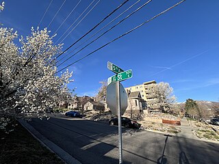
The Avenues is an affluent neighborhood in Salt Lake City, Utah. It is named after the perfectly gridlike, closely laid out roads called Avenues and Streets. First surveyed in the 1850s, the Avenues became Salt Lake City's first neighborhood. Today, the Avenues neighborhood is generally considered younger, more progressive, and somewhat "artsy" when compared to other neighborhoods. Many young professionals choose to live there due to the culture and easy commute to downtown.. It is also one of the most important strongholds of the Utah Democratic Party.

George Edgar Merrick was a real estate developer who is best known as the planner and builder of the city of Coral Gables, Florida in the 1920s, one of the first major planned communities in the United States.
Homestead Historic District is a historic district in Homestead, Munhall, and West Homestead, Pennsylvania that is listed on the National Register of Historic Places (NRHP). It may also refer to:

The Franklin Pierce Homestead is a historic house museum and state park located in Hillsborough, New Hampshire. It was the childhood home of the 14th president of the United States, Franklin Pierce.

Coral Gables Preparatory Academy, formerly Coral Gables Elementary School, is a public K-8 school in Coral Gables, Florida. A part of the Miami-Dade County Public Schools, it has its elementary school classes in the Lower Academy, in the former Coral Gables Elementary building, while the middle school classes are in the Upper Academy at the Merrick Educational Center. The school was given its current name in 2010.

Redland, long known also as the Redlands or the Redland, is a historic unincorporated community and agricultural area in Miami-Dade County, Florida, located about 20 miles (32 km) southwest of downtown Miami and just northwest of Homestead, Florida. It is unique in that it constitutes a large farming belt directly adjoining what is now the seventh most populous major metropolitan area in the United States. Named for the pockets of red clay that cover a layer of oolitic limestone, Redland produces a variety of tropical fruits, many of which do not grow elsewhere in the continental United States. The area also contains a large concentration of ornamental nurseries. The landscape is dotted with u-pick'em fields, coral rock (oolite) walls, and the original clapboard homes of early settlers and other historic early twentieth century structures.
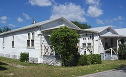
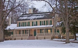
The Trapp Homestead is a historic home in the Coconut Grove section of the City of Miami, Florida, United States. It is located at 2521 South Bayshore Drive. On November 10, 1994, it was added to the U.S. National Register of Historic Places. The home was constructed in 1887 out of oolitic lime quarried locally by Caleb Trapp and his son, Harlan. During construction, the Trapps lived on a thatched hut at the front of the property. The property is believed to be the oldest-standing masonry home in Miami-Dade County, Florida. The estate's construction pre-dates the incorporation of the City of Miami. The estate was particularly notable at the time because it was one of the few stone structures in Miami-Dade County, as nearly all structures in the area were built of wood at that time.
Golden Hill is an affluent and historic neighborhood overlooking the White River on the west side of Indianapolis's Center Township, in Marion County, Indiana. The district is bounded on the east by Clifton Street, which is west of Martin Luther King Jr. Boulevard ; on the west by the White River and the Central Canal; on the south by Thirty-sixth Street; and on the north by Woodstock Country Club, immediately south of Thirty-eighth Street. Golden Hill is noted for its collection of homes designed by several of the city's prominent architects. The estate homes reflect several styles of period revival architecture. The district is known as for its community planning and remains an exclusive enclave for the city's prominent families. Golden Hill was added to the National Register of Historic Places in 1991.
The John Jay Homestead State Historic Site is located at 400 Jay Street in Katonah, New York. The site preserves the 1787 home of Founding Father and statesman John Jay (1745–1829), one of the three authors of The Federalist Papers and the first Chief Justice of the United States. The property was designated a National Historic Landmark in 1981 for its association with Jay. The house is open year-round for tours.

The Samuel L. Smith House is located at 5035 Woodward Avenue in Midtown Detroit, Michigan. It was also known as the Schools Annex. It was listed on the National Register of Historic Places in 1986.
Van Vorst Park is a neighborhood in the Historic Downtown of Jersey City, Hudson County, New Jersey, centered on a park sharing the same name. The neighborhood is located west of Paulus Hook and Marin Boulevard, north of Grand Street, east of the Turnpike Extension, and south of The Village and Christopher Columbus Drive. Much of it is included in the Van Vorst Park Historical District.
The Grant Boyhood Home is a historic house museum at 219 East Grant Avenue in Georgetown, Ohio. Built in 1823, it was where United States President and American Civil War General Ulysses S. Grant (1822–85) lived from 1823 until 1839, when he left for the United States Military Academy at West Point. In 1976, the house was listed on the National Register of Historic Places. Nine years later, it was designated a National Historic Landmark. It is now owned by a local nonprofit organization as part of a suite of Grant-related museum properties in Georgetown.
Rogers and MacFarlane was an architectural firm based in Detroit, Michigan, founded in 1885 by James S. Rogers and Walter MacFarlane. The firm produced commissions in Detroit and southern Michigan from 1885 until 1912.

The Sherman Hill Historic District is located in Des Moines, Iowa, United States. It is one of the oldest residential neighborhoods in Des Moines. Single-family houses were constructed beginning around 1880 and multi-family dwellings were built between 1900 and 1920. The district encompasses 80 acres (0.32 km2) and 210 buildings and is bounded by 15th Street to the East, High Street to the South, Martin Luther King Parkway on the West, and School Street to the North. The historic district has been listed on the National Register of Historic Places since 1979.

Eagar Townsite Historic District is a section of the town of Eagar, Arizona which has been designated a National Historic Place. Sitting on roughly 54 acres, the site contains 37 structures, 21 of which have historical significance. The period of significance is from 1886, the year the townsite was founded, through 1942, which represents the significant period of development of the town. The site was added to the Register on July 23, 1993.
2. "The Coconut Grove School," Gertrude M. Kent, Tequesta #XXXI (1971)