Miami Modernist architecture, or MiMo, is a regional style of architecture that developed in South Florida during the post-war period. The style was internationally recognized as a regionalist response to the International Style. It can be seen in most of the larger Miami and Miami Beach resorts built after the Great Depression. Because MiMo styling was a not just a response to international architectural movements but also to client demands, themes of glamour, fun, and material excess were added to otherwise stark, minimalist, and efficient styles of the era. The style can be most observed today in Middle and Upper Miami Beach along Collins Avenue, as well as along the Biscayne Boulevard corridor starting from around Midtown, through the Design District and into the Upper Eastside.
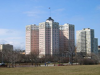
The Bryn Mawr Historic District is on the lakefront of the Edgewater neighborhood of far-north Chicago, Illinois. It extends along Bryn Mawr Avenue between Broadway Avenue and Sheridan Road. Its most prominent features are the Belle Shore Apartment Hotel, Bryn Mawr Apartment Hotel, Edgewater Beach Apartments, Edgewater Presbyterian Church, Manor House, and the northernmost area of Lincoln Park.

Lincoln Road Mall is a pedestrian road running east-west parallel between 16th Street and 17th Street in Miami Beach, Florida, United States. Once completely open to vehicular traffic, it now hosts a pedestrian mall replete with shops, restaurants, galleries, and other businesses between Washington Avenue with a traffic accessible street extending east to the Atlantic Ocean and west to Alton Road with a traffic accessible street extending to Biscayne Bay.

Haddington is a neighborhood in the West Philadelphia section of Philadelphia, Pennsylvania. Its borders are defined as Haverford Avenue/Girard Avenue to the north, 52nd Street to the east, Market Street to the south, and 67th Street to the most western edge of the neighborhood. It is a largely African American community of mostly two-story rowhouses with a large proportion of elderly residents and a high home-ownership rate. Near the intersection of Vine Street and 56th Street, new construction and community facilities were built in the 1970s thanks to the Haddington Leadership Organization.

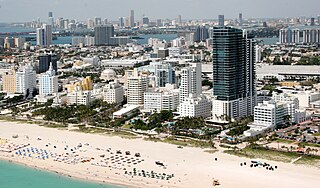
The Miami Beach Architectural District is a U.S. historic district located in the South Beach neighborhood of Miami Beach, Florida. The area was well known as the district where Italian fashion designer Gianni Versace resided, in a mansion on Ocean Drive. It is bounded by the Atlantic Ocean to the east, Sixth Street to the south, Alton Road to the west, the Collins Canal and Dade Boulevard to the north. It contains 960 historic buildings.

The Ocean Spray Hotel is a historic hotel in Miami Beach, Florida, United States built in 1937. It is located at 4130 Collins Avenue (Mid-Beach). On June 2, 2004, it was added to the U.S. National Register of Historic Places.

The Lummus Park Historic District or simply Lummus Park, is on the National Register of Historic Places and a locally historic designated district in Miami, Florida. It is roughly bound by Northwest Fifth Street to the north, Flagler Street to the south, Northwest Third Avenue to the east, and the Miami River to the west. On October 25, 2006, it was added to the U.S. National Register of Historic Places. Lummus Park has some of the oldest structures in Miami, and over the decades, has been able to retain a large part of its early pioneer character.
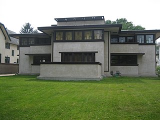
The Frank Lloyd Wright/Prairie School of Architecture Historic District is a residential neighborhood in the Cook County, Illinois village of Oak Park, United States. The Frank Lloyd Wright Historic District is both a federally designated historic district listed on the U.S. National Register of Historic Places and a local historic district within the village of Oak Park. The districts have differing boundaries and contributing properties, over 80 of which were designed by Frank Lloyd Wright, widely regarded as the greatest American architect to have ever lived.

The Kenilworth Avenue Historic District is a historic district in the northwestern portion of Dayton, Ohio, United States. Composed largely of houses constructed after the Great Flood of 1913, the district features examples of several prominent architectural styles, and it has received both local and federal recognition.

The Villa District, also known as Villa Historic District, is a historic district in Chicago, Illinois, United States. It is located on Chicago's Northwest Side within the community area of Irving Park. Its borders are along Pulaski Road to the west, the Union Pacific/Northwest rail line to the north, Hamlin Avenue to the east, and Addison Street to the south. Located directly north of the Wacławowo area of Avondale, the Villa District is serviced by the Blue Line's Addison street station.

The Old Dauphin Way Historic District is a historic district in the city of Mobile, Alabama, United States. It was named for Dauphin Way, now known as Dauphin Street, which bisects the center of the district from east to west. The district is roughly bounded by Broad Street on the east, Springhill Avenue on the north, Government Street on the south, and Houston Avenue on the west. Covering 766 acres (3.10 km2) and containing 1466 contributing buildings, Old Dauphin Way is the largest historic district in Mobile.

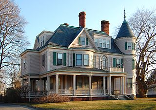
The Bellevue Avenue Historic District is located along and around Bellevue Avenue in Newport, Rhode Island, United States. Its property is almost exclusively residential, including many of the Gilded Age mansions built by affluent summer vacationers in the city around the turn of the 20th century, including the Vanderbilt family and Astor family. Many of the homes represent pioneering work in the architectural styles of the time by major American architects.

The Ocean Drive Historic District is a historic district that covers the long street of the same name along the southern shore of Newport, Rhode Island, United States. It was designated a National Historic Landmark District in 1976, in recognition for its distinctive landscape and architecture, which is less formal and generally not as ostentatious as the grand summer properties of Bellevue Avenue.

The Central Avenue Historic District is a small segment of the larger Grafton Hill neighborhood of Dayton, Ohio, United States. Composed of just two blocks near the border between Grafton Hill and Dayton View, the historic district comprises a cohesive collection of houses dating primarily from the turn of the 20th century, and it has been named a historic site.

The North Irvington Gardens Historic District is a neighborhood and national historic district in Indianapolis, Indiana. It was placed on the National Register of Historic Places on June 27, 2008. It is immediately to the north of the Irvington Historic District, which has been on the National Register since 1987, sharing the same east and west boundaries of the older district, and extending north to 10th and 11th streets. It is a neighborhood of mostly residential buildings dating primarily from 1910 to 1950, with no one distinctive architectural style, including a house associated with the historic Osborn Farm. Except for one church, the only buildings contributing to the historic nature of the district are 843 houses and 551 garages. Most fences in the district mark the perimeter of the individual properties; very few are along the streets.

Hull Shore Drive and Nantasket Avenue are a historic coastal parkway in Hull, Massachusetts. Nantasket Avenue, designated as part of Route 228, is the main road through the town of Hull. Hull Shore Drive is a short segment of the road, near the Nantasket Beach Reservation at the southern end of the Hull peninsula. A 1.25-mile (2.01 km) section of the roads was added to the National Register of Historic Places in 2004.
The Diamond Historic District is a seaside, 69.5-acre (28.1 ha) National Register historic district in Lynn, Massachusetts. Established by the National Park Service in 1996, the district is situated between downtown Lynn and the Atlantic Ocean--bounded roughly by Broad and Lewis Streets to the north, Lynn Shore Drive to the southeast, Nahant Street to the west, and Eastern Avenue to the east. The Diamond Historic District encompasses 590 contributing resources.

The architectural firm of Kiehnel and Elliot was established in Pittsburgh, Pennsylvania, in 1906. The firm did substantial work in Florida, and moved to Miami in 1922. From 1926, it was known as Kiehnel, Elliot and Chalfant.

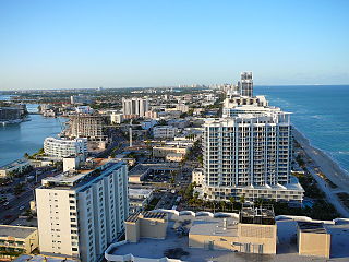
The Collins Waterfront Architectural District is a historic district in Miami Beach, Florida, that includes 110 contributing buildings and structures built in the late 1940s, 1950s and 1960s, centering on Collins Avenue. The predominant styles include moderne, Art Deco and Mediterranean Revival architecture, as well as the local Miami Modern style. The chief contributing resources are large resort hotels. The district is bounded by the Atlantic Ocean on the east, and by 24th Street, Indian Creek Drive, Pine Tree Drive and the Collins Canal. The district is part of Mid-Beach.