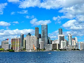
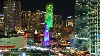
Miami, officially the City of Miami, is a coastal metropolis and the seat of Miami-Dade County in South Florida. With a population of 442,241 as of the 2020 census, it is the second-most populous city in the state of Florida after Jacksonville. It is the core of the much larger Miami metropolitan area, which, with a population of 6.14 million, is the third-largest metro in the Southeast and ninth-largest in the United States. The city has the third-largest skyline in the U.S. with over 300 high-rises, 58 of which exceed 491 ft (150 m).

Biscayne Bay is a lagoon with characteristics of an estuary located on the Atlantic coast of South Florida. The northern end of the lagoon is surrounded by the densely developed heart of the Miami metropolitan area while the southern end is largely undeveloped with a large portion of the lagoon included in Biscayne National Park.

Government Center station is an intermodal transit hub in the Government Center district of Downtown Miami, Florida. It is operated by Miami-Dade Transit and serves as a transfer station for the Metrorail and Metromover rapid transit systems and as a bus station for Metrobus, Paratransit, and Broward County Transit buses. The station is located near the intersection of Northwest First Street and First Avenue, a part of the Stephen P. Clark Government Center Building. It opened to service May 20, 1984, next to the site of a former FEC railway station which is now MiamiCentral.

Bayfront Park is a Metromover station in Downtown, Miami, Florida, adjacent to Bayfront Park.

Julia DeForest Tuttle was an American businesswoman who owned the property upon which Miami, Florida, was built. For this reason, she is called the "Mother of Miami." She is the only woman to have founded what would become a major American city.

Fort Dallas was a military base during the Seminole Wars on the banks of the Miami River in what is now Downtown Miami, Florida, United States.
Thousands of years before Europeans arrived, a large portion of south east Florida, including the area where Miami, Florida exists today, was inhabited by Tequestas. The Tequesta Native American tribe, at the time of first European contact, occupied an area along the southeastern Atlantic coast of Florida. They had infrequent contact with Europeans and had largely migrated by the middle of the 18th century. Miami is named after the Mayaimi, a Native American tribe that lived around Lake Okeechobee until the 17th or 18th century.

Flagler Street is a 12.4-mile (20.0 km) main east–west road in Miami. Flagler Street is the latitudinal baseline that divides all the streets on the Miami-Dade County grid plan as north or south streets. Flagler Street is named after industrialist Henry Flagler and serves as a major commercial east–west highway through central Miami-Dade County, with a mixture of residential neighborhoods and strip malls, the commercial presence increasing as SR 968 approaches downtown Miami.
Manhattanization is a neologism coined to describe the construction of many tall or densely situated buildings, which transforms the appearance and character of a city to what is similar to Manhattan, the most densely populated borough of New York City. It was a pejorative word used by critics of the highrise buildings built in San Francisco during the 1960s and 1970s, who claimed the skyscrapers would block views of the bay and the surrounding hills. With careful urban planning, the phenomenon became more accepted in time. The term also gained usage as a buzzword for high-density developments in Las Vegas, Los Angeles, Dubai, and Miami in the early 2000s and again in the 2010s. Another example is the high rise development in Toronto since 2007, as well as rapid development of skyscrapers in Hong Kong and Tokyo since the 1970s, eventually allowing Hong Kong to possess more skyscrapers than New York. The term has even been applied to many smaller US cities that have seen a large spike in downtown high rise rental buildings since the 21st century. Nonetheless, these cities would have to multiply their populations many times over to match the population density of Manhattan, though this is a biased comparison between a city and a district, as even the other four "outer boroughs" of New York City would have to nearly triple in population to match Manhattan's current density.

The Venetian Islands are a chain of artificial islands in Biscayne Bay in the cities of Miami and Miami Beach, Florida. The islands are, from west to east: Biscayne Island (Miami), San Marco Island (Miami), San Marino Island, Di Lido Island, Rivo Alto Island, and Belle Isle. Flagler Monument Island remains an uninhabited picnic island, originally built in 1920 as a memorial to railroad pioneer Henry Flagler. The islands are connected by bridges from the Miami mainland to Miami Beach.
Brickell is a neighborhood in Miami, Florida located directly east of Interstate 95, south of the historic CBD, and north of Coconut Grove. Brickell is known as the financial district of Miami, as well as South Florida.

The Downtown Miami Historic District is a U.S. historic district located in the Central Business District of Downtown Miami, Florida.
Downtown Miami is the urban city center of Miami, Florida, United States. The city's greater downtown region consists of the Central Business District, Brickell, the Historic District, Government Center, the Arts & Entertainment District, and Park West. It is divided by the Miami River and is bordered by Midtown Miami's Edgewater and Wynwood sections to its north, Biscayne Bay to its east, the Health District and Overtown to its west, and Coconut Grove to its south.

Miami Avenue is a 16.8-mile (27.0 km) main north–south street running through Coconut Grove, Brickell, Downtown, and Midtown in Miami, Florida. It is the meridian road dividing the street grid of Miami and Miami-Dade County into east and west avenues.

Brickell Avenue is a north–south road that is part of U.S. Route 1, in Miami, Florida, just south of the Miami River. North of the Brickell Avenue Bridge, U.S. Route 1 is known as Biscayne Boulevard. Brickell Avenue is the main road through the Brickell financial district of Downtown Miami and is considered the Park Avenue of Florida. Brickell Avenue is lined with high-rise office buildings and residential condominiums, as well as many banks and restaurants. It is also famed for "Millionaire Row's" home to a cluster of Miami's most expensive residences.

The Upper Eastside is a neighborhood in Miami, Florida. It is north of Edgewater, east of Little Haiti, south of the village of Miami Shores, and sits on Biscayne Bay. In geographical order from south to north and east to west, it contains the subdivisions of Magnolia Park, Bay Point, Morningside, Bayside, Belle Meade, Shorecrest, and Palm Grove. The MiMo District along Biscayne Boulevard in the area is host to many art galleries, shops and restaurants.

The Arts & Entertainment District, or previously known as Omni, is a neighborhood of Downtown Miami, Florida. It is bound roughly by North 19th Street to the north, North 10th Street to the south, North West 2nd Avenue to the west, and Biscayne Boulevard to the east.

The Greater Miami area, composed of the three counties of Miami-Dade, Broward, and Palm Beach, also known collectively as South Florida, is home to a wide variety of public and private transportation systems. These include heavy rail mass transit (Metrorail), commuter rail (Tri-Rail), automated guideway transit (Metromover), highways, two major airports and seaports, as well as three county-wide bus networks, which cover the entire urbanized area of South Florida. Census and ridership data show that Miami has the highest public transportation usage of any city in Florida, as about 17% of Miamians use public transportation on a regular basis, compared to about 4% of commuters in the South Florida metropolitan area. The majority of public transportation in Miami is operated by Miami-Dade Transit (MDT), which is currently the largest transit system in Florida and was the 14th largest transit system in the United States in 2011.