Government Center station (Miami)

Last updated

Government Center
Transit at Government Center.jpg
Three modes of transit operating simultaneously at Government Center station
General information
Location101 NW 1st Street (Metrorail)
138 NW 3rd Street (Metromover)
Miami, Florida
Coordinates 25°46′33″N80°11′45″W / 25.77583°N 80.19583°W / 25.77583; -80.19583
Owned by Miami-Dade County
Platforms
Tracks
  • 2 (Metrorail)
  • 2 (Metromover)
Connections
Construction
Structure typeElevated
Platform levels4
AccessibleYes
Other information
Station codeGVT
History
Opened
  • May 20, 1984 (Metrorail) [2]
  • April 17, 1986 (Metromover)
Passengers
20113.2 million [3] (Metrorail)Increase2.svg 3%
Preceding station MDTMetro.svg Miami-Dade Transit Following station
Brickell Green Line Historic Overtown/Lyric Theatre
toward Palmetto
Orange Line Historic Overtown/Lyric Theatre
Third Street
toward School Board
Omni Loop Wilkie D. Ferguson Jr.
One-way operation
Third Street Brickell Loop
Miami Avenue
One-way operation
Inner Loop Wilkie D. Ferguson Jr.
Next clockwise
Former services
Preceding station MDTMetro.svg Miami-Dade Transit Following station
Brickell Downtown Express Terminus
Location
Government Center station (Miami)

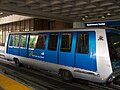
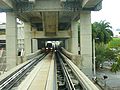
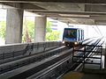
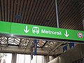
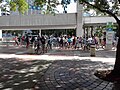
Government Center station is an intermodal transit hub in the Government Center district of Downtown Miami, Florida. Operated by Miami-Dade Transit, it serves as a transfer station for the Metrorail rapid transit and Metromover people mover systems, and as a bus station for Miami's Metrobus and, during weekday rush hours, Broward County Transit buses. The station is connected via a pedestrian bridge over NW 3rd Street to the southern end of MiamiCentral and is directly linked to the Stephen P. Clark Government Center Building. It opened on May 20, 1984, adjacent to the site of a former Florida East Coast Railway station.

Contents

History

Metrorail and Metromover station

Schematic of 2018 rapid transit and passenger rail service in the Miami metropolitan area Miami Metro Map 2017.png
Schematic of 2018 rapid transit and passenger rail service in the Miami metropolitan area

Development of the civic center was reinvigorated during the 1970s and early 1980s amid a Downtown building boom, which led to the construction of the Stephen P. Clark Government Center, Metrorail, Metromover, and the Miami-Dade Cultural Plaza, home to HistoryMiami and the Miami-Dade Public Library System Main Library.

Construction on the present-day Government Center station began in June 1982. The station was designed by Cambridge Seven Associates in collaboration with Edward D. Stone and built by the Frank J. Rooney Construction Company. Metrorail service between Overtown and Kendall commenced in May 1984, following the former Florida East Coast Railway route.

An unused, partially completed "ghost platform" for a future East-West Metrorail line is located on the mezzanine level below the current Metrorail platform, visible to passengers transferring from Metromover. This platform was part of the original design concept interfacing with the atrium of the Miami-Dade County Administration Building and the Metromover station.

Florida East Coast Railroad station

The station is adjacent to the former site of a railroad station built in April 1896 as the southern terminus of Henry Flagler's Florida East Coast Railway (FEC). The terminal was demolished by November 1963. [5] The FEC retained ownership of the site, which was used as parking lots until 2014. It is now MiamiCentral, an intermodal hub served by Brightline higher-speed inter-city trains since 2018 and Tri-Rail commuter trains since 2024.

Station layout

The second floor contains the main Metrorail fare control area, Metromover platforms, and the Metrofare Shops retail area.

The third floor serves as a mezzanine for transfers between Metrorail and Metromover, includes the unused east–west "ghost platform," and features a pedestrian bridge connecting directly to the southern end of MiamiCentral for Brightline and Tri-Rail passengers.

The fourth floor houses the Metrorail platform, the highest in the Miami-Dade Transit system, capable of accommodating up to eight-car trains.

Transit connections

Metrobus

Broward County Transit

RouteDescriptionMapNotes
10995 Express (Downtown Miami ↔ Pines Boulevard (SR 820) at Flamingo Road (SR 823) via I-95 and Pines Blvd) Map Weekday rush hour only; limited-stop
110595 Express (Sunrise BB&T Center ↔ Downtown Miami and Brickell via I-95) Map Weekday rush hour only; limited stop

Miami Trolley

RouteMap
Coral Way Map

Places of interest

See also

References

  1. "Metrorail Map" (PDF). Miami-Dade Transit . October 2025. Retrieved January 26, 2026.
  2. "Free Rides Bring Out Thousands to Opening of Miami Metrorail". The Tampa Tribune . May 21, 1984. pp. 1B–2B . Retrieved September 18, 2023 via Newspapers.com. Open Access logo PLoS transparent.svg
  3. http://www.miamidade.gov/transit/news_technical_reports_archive.asp%5B%5D
  4. 1 2 "RIDERSHIP TECHNICAL REPORT". Miami-Dade County Transit. Retrieved June 2, 2014.[ permanent dead link ]
  5. Howe, Ward Allan (November 3, 1963). "THE FLORIDA RUN: Railroads Anticipating a Busy Winter—New Schedule Effective Dec. 13" (PDF). New York Times . p. XX13. Retrieved March 29, 2011.