Homestead is a city within Miami-Dade County in the U.S. state of Florida, between Biscayne National Park to the east and Everglades National Park to the west. Homestead is primarily a Miami suburb and a major agricultural area. It is a principal city of the Miami metropolitan area, which was home to an estimated 6,012,331 people at the 2015 census.

Miami-Dade Transit (MDT) is the primary public transit authority of Miami, Florida, United States and the greater Miami-Dade County area. It is the largest transit system in Florida and the 15th-largest transit system in the United States. Ridership dropped 27% from 2010 to 2018. From 2014 to 2018, each year there fewer riders than the prior year.

Metromover is a free mass transit automated people mover train system operated by Miami-Dade Transit in Miami, Florida, United States. Metromover serves the Downtown Miami, Brickell, Park West and Arts & Entertainment District neighborhoods. Metromover connects directly with Metrorail at Government Center and Brickell stations. It also connects to Metrobus with dedicated bus loops at Government Center and Adrienne Arsht Center station. It originally began service to the Downtown/Inner Loop on April 17, 1986, and was later expanded with the Omni and Brickell Loop extensions on May 26, 1994.

Government Center station is an intermodal transit hub in the Government Center district of Downtown Miami, Florida. It is operated by Miami-Dade Transit and serves as a transfer station for the Metrorail and Metromover rapid transit systems and as a bus station for Metrobus, Paratransit, and Broward County Transit buses. The station is located near the intersection of Northwest First Street and First Avenue, a part of the Stephen P. Clark Government Center Building. It opened to service May 20, 1984, next to the site of a former FEC railway station which is now MiamiCentral.

Brickell station is a Metrorail rapid transit station in Miami, Florida, serving the system's Green and Orange Lines. One of the core stations of Miami's public transport network, it serves the financial district of Brickell. Combined, the Metrorail and Metromover station complex at Brickell sees roughly 8,430 boardings each weekday, making it the system's second-busiest station.

Brickell is an urban neighborhood of Greater Downtown Miami, Florida, United States. Directly south of the historic CBD, Brickell is Miami and South Florida's major financial district.
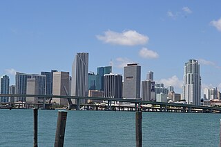
Downtown Miami is an urban city center, based around the Central Business District of Miami, Florida, United States. In addition to the central business district, the area also consists of the Brickell Financial District, Historic District, Government Center, Arts & Entertainment District and Park West. The neighborhood is divided by the Miami River and is bordered by Midtown to the north, Biscayne Bay to the east, Civic Center and Overtown to the west, and Coconut Grove to the south.

Metrorail is the heavy rail rapid transit system of Miami and Miami-Dade County in the U.S. state of Florida. Metrorail is operated by Miami-Dade Transit (MDT), a departmental agency of Miami-Dade County. Opened in 1984, it is Florida's only rapid transit metro system, and is currently composed of two lines of 23 stations on 24.4 miles (39.3 km) of standard gauge track. Metrorail serves the urban core of Miami, connecting the urban centers of Miami International Airport, the Civic Center, Downtown Miami, and Brickell with the northern developed neighborhoods of Hialeah and Medley to the northwest, and to suburban The Roads, Coconut Grove, Coral Gables, and South Miami, ending at urban Dadeland in Kendall. Metrorail connects to the Metromover in Downtown, which provides metro service to the entirety of Downtown and Brickell. Additionally, it connects to South Florida's commuter rail system at Tri-Rail station, as well as Metrobus routes at all stations. Together with Metromover, the system saw steady ridership growth per annum, with an average of 105,500 daily passengers in 2013.

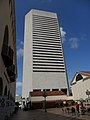
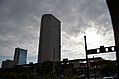
The Stephen P. Clark Government Center, known also as Government Center, Miami-Dade Center, or County Hall, is a skyscraper in the Government Center district of Downtown Miami, Florida, United States. It is the headquarters building of the Miami-Dade County government. Many county offices are located in or near the building. The local and federal courthouses are located within five blocks of the building. The tower is 510 ft tall, and has 28 stories. It has one of the highest height-to-floor ratios of any skyscraper, at 18.2 feet per floor. The Government Center Metro Station is located inside the building, giving it easy access to public transit. It is located in western downtown, on North First Street between West First and West Second Avenue. The building was completed in 1985. It is named after the former Mayor of Miami-Dade County and Mayor of Miami, Stephen P. Clark (1923-1996).
Miami Dade College is one of Miami Dade College’s eight campuses. The campus was opened in 1970, holding classes in storefronts in Downtown. As the only comprehensive urban campus in the City of Miami, Wolfson Campus has played an integral part in the effort to develop the downtown skyline.

Dadeland is a commercial district and urban neighborhood similar to an edge city, amid the sprawling metropolitan Miami suburbs of Kendall, Glenvar Heights, and Pinecrest, in the U.S. state of Florida, at the end of the Metrorail line.
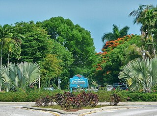
The Roads is a neighborhood of Miami in Miami-Dade County, Florida, United States. It is a triangular area located south of SW 11th Street, between SW 12th Avenue and SW 15th Road, just west of Brickell.

The Arts & Entertainment District, or previously known as Omni, is a neighborhood of greater Downtown, Miami, Florida, United States, just south of Edgewater. It is bound roughly by North 19th Street to the north, North 10th Street to the south, North East 2nd Avenue to the west, and Biscayne Boulevard to the east.

Park West is a neighborhood of Greater Downtown, Miami, Florida, United States. It is roughly bound by Biscayne Boulevard to the east, West (NW) First Avenue to the west, North (NE/NW) 7th Street to the south and Interstate 395 to the north. As of 2010, about 4,655 residents live in Park West. The neighborhood is named 'Park West' due to its location just west of Museum Park.
The Greater Miami area, composed of the three counties of Miami-Dade, Broward, and Palm Beach, also known collectively as South Florida, is home to a wide variety of public and private transportation systems. These include heavy rail mass transit (Metrorail), commuter rail (Tri-Rail), automated guideway transit (Metromover), highways, two major airports and seaports, as well as three county-wide bus networks, which cover the entire urbanized area of South Florida. Census and ridership data show that Miami has the highest public transportation usage of any city in Florida, as about 17% of Miamians use public transportation on a regular basis, compared to about 4% of commuters in the South Florida metropolitan area. The majority of public transportation in Miami is operated by Miami-Dade Transit (MDT), which is currently the largest transit system in Florida and was the 14th largest transit system in the United States in 2011.

The Metrobus network provides bus service throughout Miami-Dade County 365 days a year. It consists of about 93 routes and 893 buses, which connect most points in the county and part of southern Broward County as well. Seven of these routes operate around the clock: Routes 3, 11, 27, 38, 77, L and S. Routes 246 Night Owl & Route 500 Midnight Owl operate from midnight to 5 am. Most other routes operate from 4:30 am to 1:30 am. Available via the Google Play Store and Apple App Store exist the GO Miami-Dade Transit app to track the different bus routes, to view the time of arrival at specific stops, purchase tickets for Metrorail, Metrobus, and Tri-rail. All Metrobuses are wheelchair accessible, in compliance with the Americans with Disabilities Act of 1990 and equipped with Bicycle racks.

Central Business District (CBD) is the historic city center of what has become Greater Downtown Miami, in Miami, Florida, United States. It has a total employment of 92,189 as of 2012-2016. It is generally bound by Biscayne Boulevard, Bayfront Park and Museum Park on the east, the Miami River to the south, North 6th Street to the north, and Interstate 95 to the west. While it is technically Miami's official "downtown", the term "Downtown Miami" has come to refer to a much larger 3.8-square-mile (10 km2) area along the bay from the Rickenbacker Causeway to the Julia Tuttle Causeway. It is also distinct from the financial district, which in this case is neighboring Brickell to the south. However, the downtown core has over 5,000,000 square feet (460,000 m2) of office space, including more than fifteen buildings with greater than 100,000 sq ft (9,300 m2) of floor space.
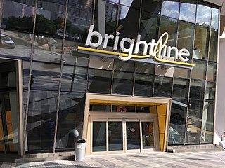
MiamiCentral is a mixed-use railroad station development in the Government Center district of Downtown, Miami, Florida. Currently, the station serves an inter-city rail service named Brightline and connects to the adjacent Government Center station serving Metrorail, Metromover, and bus lines. In the next few years, the station will serve Tri-Rail commuter rail. The 9-acre (3.6 ha) complex also includes 3 million square feet (280,000 m2) of residential, office, commercial, and retail development. The station was built by All Aboard Florida, a subsidiary of Florida East Coast Industries (FECI) overseeing Brightline. MiamiCentral was designed by Skidmore, Owings & Merrill in association with Zyscovich Architects.