Omni (Miami)

Last updated
Omni
Neighborhood of Miami

Omni night skyline.jpg

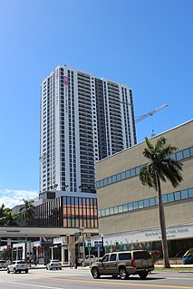
Omni viewed at night in May 2011 from Watson Island
Nickname(s): Media and Entertainment District
Miami neighborhoodsmap.png
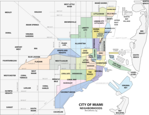
Omni neighborhood within the City of Miami
Coordinates: 25°47′56″N80°11′22″W / 25.798964°N 80.189552°W / 25.798964; -80.189552
Country United States
State Florida
County Miami-Dade County
City Miami
Government
  City of Miami Commissioner Marc Sarnoff
  Miami-Dade Commissioners Audrey Edmonson
   House of Representatives Cynthia A. Stafford (D)
   State Senate Gwen Margolis (D)
   U.S. House Ileana Ros-Lehtinen (R)
Population (2010) [1]
  Total 11,033 (Omni population only)
71,000 (Greater Downtown population)
  Density 20,585/sq mi (7,948/km2)
Time zone EST (UTC-05)
ZIP Code 33132
Area code(s) 305, 786
Website Miami Downtown Development Authority

The Omni, or sometimes labeled as the Arts and Entertainment District, is a neighborhood of greater Downtown, Miami, Florida, United States, just south of Edgewater. It is bound roughly by North 24th Street to the north, Interstate 395 to the south, by the Florida East Coast Railway and North East 2nd Avenue to the west, and Biscayne Bay to the east. [2] [3]

Miami City in Florida, United States

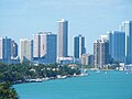
Miami, officially the City of Miami, is the cultural, economic and financial center of South Florida. Miami is the seat of Miami-Dade County, the most populous county in Florida. The city covers an area of about 56.6 square miles (147 km2), between the Everglades to the west and Biscayne Bay on the east; with a 2017 estimated population of 463,347, Miami is the sixth most densely populated major city in the United States. The Miami metropolitan area is home to 6.1 million people and the seventh-largest metropolitan area in the nation. Miami's metro area is the second-most populous metropolis in the southeastern United States and fourth-largest urban area in the U.S. Miami has the third tallest skyline in the United States with over 300 high-rises, 80 of which stand taller than 400 feet.

Florida State of the United States of America

Florida is the southernmost contiguous state in the United States. The state is bordered to the west by the Gulf of Mexico, to the northwest by Alabama, to the north by Georgia, to the east by the Atlantic Ocean, and to the south by the Straits of Florida. Florida is the 22nd-most extensive, the 3rd-most populous, and the 8th-most densely populated of the U.S. states. Jacksonville is the most populous municipality in the state and the largest city by area in the contiguous United States. The Miami metropolitan area is Florida's most populous urban area. Tallahassee is the state's capital.

United States Federal republic in North America

The United States of America (USA), commonly known as the United States or America, is a country comprising 50 states, a federal district, five major self-governing territories, and various possessions. At 3.8 million square miles, the United States is the world's third or fourth largest country by total area and is slightly smaller than the entire continent of Europe's 3.9 million square miles. With a population of over 327 million people, the U.S. is the third most populous country. The capital is Washington, D.C., and the largest city by population is New York City. Forty-eight states and the capital's federal district are contiguous in North America between Canada and Mexico. The State of Alaska is in the northwest corner of North America, bordered by Canada to the east and across the Bering Strait from Russia to the west. The State of Hawaii is an archipelago in the mid-Pacific Ocean. The U.S. territories are scattered about the Pacific Ocean and the Caribbean Sea, stretching across nine official time zones. The extremely diverse geography, climate, and wildlife of the United States make it one of the world's 17 megadiverse countries.

Contents

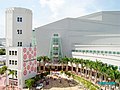
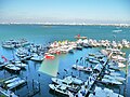
Omni is an urban, residential neighborhood with many high-rise residential towers, as well as some smaller scale historic buildings. Omni is home to the Adrienne Arsht Center for the Performing Arts, the old Miami Herald headquarters (now located in Doral, Florida), and the Omni International Mall. Until 2014 it was one of the neighborhoods that hosted the annual Miami International Boat Show [4] at the Sea Isle Marina. The City of Miami Cemetery, one of Miami's oldest cemeteries, is also located in Omni, as well as the historic Women's Club, and some of Miami's oldest churches and synagogues.

Adrienne Arsht Center for the Performing Arts

The Arsht Center is a performing arts center and is located Miami, Florida. It is one of the largest performing arts centers in the United States.

<i>Miami Herald</i> American daily newspaper

The Miami Herald is a daily newspaper owned by the McClatchy Company and headquartered in Doral, Florida, a city in western Miami-Dade County and the Miami metropolitan area, several miles west of downtown Miami. Founded in 1903, it is the second largest newspaper in South Florida, serving Miami-Dade, Broward, and Monroe Counties. It also circulates throughout Latin America and the Caribbean.

Doral, Florida City in Florida

Doral is a city in Miami-Dade County, Florida, United States. One of thirty-four municipalities in the county, it is located just one mile from Miami International Airport and 13 miles (21 km) from Downtown Miami. The city regularly hosts in excess of 100,000 people who work in Miami. The City of Doral occupies a land area of 15 square miles (39 km2) bordered on the west by the Ronald Reagan Turnpike, to the north by the Town of Medley, to the east by the Palmetto Expressway and to the South by the City of Sweetwater. Doral is a principal city of the Miami metropolitan area, which was home to an estimated 6,012,331 people at the 2015 census.

Omni is served by the Omni Loop branch of the Metromover and by the Metrorail via Metromover at Government Center.

Metromover rapid transit system in Miami, Florida

Metromover is a free mass transit automated people mover train system operated by Miami-Dade Transit in Miami, Florida, United States. Metromover serves the Downtown Miami, Brickell, Park West and Arts & Entertainment District neighborhoods. Metromover connects directly with Metrorail at Government Center and Brickell stations. It also connects to Metrobus with dedicated bus loops at Government Center and Adrienne Arsht Center station. It originally began service to the Downtown/Inner Loop on April 17, 1986, and was later expanded with the Omni and Brickell Loop extensions on May 26, 1994.

History

From the 1920s to the 1950s, the Omni area was a high-end shopping area with many major department stores along Biscayne Boulevard, such as Sears, Roebuck and Company (whose tower still stands at the Arsht Center), Jordan Marsh (NE 15th Street and Biscayne Blvd) built in 1956, and a Burdines (NE 14th Street and Biscayne Blvd). [5] By 1930, this area of Biscayne Boulevard was the home of Sears (later Burdines) Store, and the Shrine Building (which still stands at NE 14th Street and Biscayne Blvd), all of which were designed and built by the Biscayne Boulevard Company in the Art Deco architectural style. The area from NE 13th to NE 16th Street was envisioned as a high-end shopping district. By 1930, early tenants in the Shrine Building included the Piggly-Wiggly grocery store, Biscayne-Page Electric Company, and the John Turner Piano Store on the first floor. Other tenants in 1930 were the Home Drug Store and the Burroughs Adding Machine Company. [6]

Jordan Marsh

Jordan Marsh was an American department store chain that was headquartered in Boston, Massachusetts and operated throughout New England. It was founded by Eben Dyer Jordan and Benjamin L. Marsh in 1841. The ownership of Jordan Marsh was transferred between several holding companies during its operation, including Hahn Department Stores in 1928, Allied Stores in 1935, and Federated Department Stores in 1988. The brand was retired, and most stores were converted into the Cincinnati-based Macy's, in 1996.

Burdines was an American department store chain operating in the state of Florida. The original store opened in Bartow, Florida in 1896 as a carriage-trade shop. In the Twentieth Century, Burdines grew into a popular chain of department stores, known as 'The Florida Store,' decorated with palm trees in the center of the store, painted in pink and blue, and other subtropical colors and motifs. In 1956, the stores became a part of Federated Department Stores, Inc. On January 30, 2004, it was renamed Burdines-Macy's, and a year later, on March 6, 2005, the name Burdines was dropped altogether.

Sears, Roebuck and Company Department Store (Miami, Florida)

The Sears, Roebuck and Company Department Store in Miami, Florida was an Art Deco building built in 1929 for Sears, Roebuck and Company. The building was the first known implementation of Art Deco architecture in the county and was spectacular. It was followed a year later by the Shrine Building, an application of Art Deco with local Seminole Indian motifs added as an interesting twist. Both were covered in a 1988 study of Downtown Miami historic resources, but were not NRHP-listed due to owner objections at the time. It was listed on the National Register of Historic Places in August 8, 1997. Only its tower remains.

In 1977, the Omni International Mall opened replacing much of the street-side stores with a suburban-style shopping mall. The mall brought many upscale stores to the Omni such as Emilio Pucci, Givenchy and Hermes. By the 1990s, however, the mall began to falter, and in 1991, Jordan Marsh closed, and in 1998, so did JC Penney. In 2000, the mall closed, and the area was reconverted into offices in 2007. Today, it houses a few office tenants and the Miami International University of Art and Design. It is also the corporate home of the Greater Miami Chamber of Commerce. The name of the neighborhood today, comes from the name of the Omni Mall. [7] [8]

Omni International Mall

Omni International Mall was a shopping mall that opened in February 1977 in the northern environs of Downtown Miami's Arts & Entertainment District in Miami-Dade County, Florida, United States.

Shopping mall complex of shops

A shopping mall is a modern, chiefly North American, term for a form of shopping precinct or shopping center, in which one or more buildings form a complex of shops representing merchandisers with interconnecting walkways that enable customers to walk from unit to unit. A shopping arcade is a specific type of shopping precinct which is usually distinguished in English for mall shopping by the fact that connecting walkways are not owned by a single proprietor and are in open air. Shopping malls in 2017 accounted for 8% of retailing space in the United States.

Don Emilio Pucci, Marchese di Barsento was a Florentine Italian fashion designer and politician. He and his eponymous company are synonymous with geometric prints in a kaleidoscope of colors.

In the 2000s, rapid construction of high-rise residential skyscrapers has revitalized the neighborhood from urban blight. The area around Margaret Pace Park has seen large population growth from 2000 to 2010. Omni today has a large residential population, and with continued retail and residential construction in the neighborhood, has grown into its own unique neighborhood in the city.

Skyscraper tall building

A skyscraper is a continuously habitable high-rise building that has over 40 floors and is taller than approximately 150 m (492 ft). Historically, the term first referred to buildings with 10 to 20 floors in the 1880s. The definition shifted with advancing construction technology during the 20th century. Skyscrapers may host commercial offices or residential space, or both. For buildings above a height of 300 m (984 ft), the term "supertall" can be used, while skyscrapers reaching beyond 600 m (1,969 ft) are classified as "megatall".

Education

Transportation

Metromover is a popular way of getting around the Downtown area. It connects the area's neighborhoods and can get very busy during rush hour. Crowded Metromover.jpg
Metromover is a popular way of getting around the Downtown area. It connects the area's neighborhoods and can get very busy during rush hour.

Metromover train system runs three lines throughout Downtown (the Downtown Loop, the Omni Loop, and the Brickell Loop). The Metromover connects with Metrorail and is free. There are two Metromover stations in Omni- School Board Station and Adrienne Arsht Center. Transfers can be made to the Metrorail, Miami's heavy rail system, at Government Center, as well as to the Brickell and Inner Metromover loops. Metrorail has stops throughout Miami with connections to Miami International Airport, all Miami-Dade County bus lines, Tri-Rail and Amtrak. The main bus station is also located in Omni, next to the Arsht Center at the Adrienne Arsht Center station.

Omni is served by Metrobus throughout the area, the Miami Metrorail, and the Metromover:

Metrorail:

Metromover:

As an urban and pedestrian-friendly area with an extensive public transit network, Omni and the greater Downtown area, is one of the areas in Miami where a car-free lifestyle is commonplace. Many Omni residents get around by foot, bicycle, Metromover or by taxi. The Metromover is a popular alternative to walking in the area, especially on rainy, hot or cold days, as the Metromover is free, and stations are located roughly every two blocks throughout the area.

Recently, the City of Miami, along with the Downtown Development Authority, has begun bicycle initiaves promoting citywide bike parking and bike lanes, that have made bicycling much more popular for residents. Bike lanes and bike sharrows are currently planned for the majority of Downtown streets to be painted by the end of 2010. The Venetian Causeway is a popular bicycle commuter route that connects South Beach to Omni. The Rickenbacker Causeway is very popular on weekends for recreational bicyclists, and often, bicycles can outnumber cars on the causeway. [9]

Parks

Historic Omni

Although one of Miami's oldest neighborhoods, few buildings remain in Omni from its founding days. Some historic buildings in Omni include:

Points of interest

Related Research Articles

South Beach Neighborhood of Miami Beach in Miami-Dade County, Florida, United States

South Beach, also nicknamed SoBe, is a neighborhood in the city of Miami Beach, Florida, United States, located due east of Miami city proper between Biscayne Bay and the Atlantic Ocean. The area encompasses all of the barrier islands of Miami Beach south of Indian Creek.

Miami-Dade Transit

Miami-Dade Transit (MDT) is the primary public transit authority of Miami, Florida, United States and the greater Miami-Dade County area. It is the largest transit system in Florida and the 15th-largest transit system in the United States.

Government Center station (Miami) Miami Metromover station

Government Center station is an intermodal transit hub in the Government Center district of Downtown Miami, Florida. It is operated by Miami-Dade Transit and serves as a transfer station for the Metrorail and Metromover rapid transit systems and as a bus station for Metrobus, Paratransit, and Broward County Transit buses. The station is located near the intersection of Northwest First Street and First Avenue, a part of the Stephen P. Clark Government Center Building. It opened to service May 20, 1984, next to the site of a former FEC railway station which is now Virgin MiamiCentral.

Adrienne Arsht Center station Miami Metromover station

Adrienne Arsht Center station, formerly Omni station, is a Metromover station in the Arts & Entertainment District neighborhood of Downtown, Miami, Florida, United States. The station is adjacent to the Adrienne Arsht Center for the Performing Arts, just west of The Miami Herald building and the Venetian Causeway, and directly south of the MacArthur Causeway.

First Street station (Miami) Miami Metromover station

First Street is a Metromover station in Downtown, Miami, Florida.

Venetian Islands, Florida Neighborhood of Miami in Miami-Dade County, Florida, United States

The Venetian Islands are a chain of artificial islands in Biscayne Bay in the cities of Miami and Miami Beach, Florida. The islands are, from west to east: Biscayne Island (Miami), San Marco Island (Miami), San Marino Island, Di Lido Island, Rivo Alto Island, and Belle Isle. Flagler Monument Island remains an uninhabited picnic island, originally built in 1920 as a memorial to railroad pioneer Henry Flagler. The islands are connected by bridges from the Miami mainland to Miami Beach.

Brickell Neighborhood of Miami in Miami-Dade County, Florida, United States

Brickell is an urban neighborhood of Greater Downtown Miami, Florida, United States. Directly south of the historic CBD, Brickell is Miami and South Florida's major financial district.

Greater Downtown Miami Neighborhood of Miami in Miami-Dade County, Florida, United States

Downtown Miami is an urban city center, based around the Central Business District of Miami, Florida, United States. In addition to the central business district, the area also consists of the Brickell Financial District, Historic District, Government Center, Arts & Entertainment District and Park West. The neighborhood is divided by the Miami River and is bordered by Midtown to the north, Biscayne Bay to the east, Civic Center and Overtown to the west, and Coconut Grove to the south.

The Loft 2

The Loft 2 is a residential skyscraper in the Central Business District of Downtown Miami, Florida, United States. It is part of the complex "Loft Miami", which includes the shorter "The Loft" and "The Loft 3", which was cancelled. The building was completed in 2007. It is 433 ft tall, and contains 36 floors. The complex is located at NE 2nd Street and NE 2nd Avenue, two blocks west of Biscayne Boulevard. The First Street Metromover Station passes through the Loft 2 building. This made construction especially difficult, as metro train service could not be delayed during construction. Retail occupies the bottom floor, while floors 2-36 are residential lofts and condominiums. The Loft 2 has 496 units which sold out in two and a half days.

Upper Eastside Neighborhood of Miami in Miami-Dade County, Florida, United States

The Upper Eastside is a neighborhood in Miami, Florida, United States. It is north of Edgewater, east of Little Haiti, south of the village of Miami Shores, and sits on Biscayne Bay. In geographical order from south to north and east to west, it contains the subdivisions of Magnolia Park, Bay Point, Morningside, Bayside, Belle Meade, Shorecrest, and Palm Grove. The MiMo District along Biscayne Boulevard in the area is host to many art galleries, shops and restaurants.

Museum Park (Miami) park in Miami, United States

Museum Park is a 30-acre (0.12 km2) public, urban park in downtown Miami, Florida. The park opened in 1976 as Bicentennial Park on the site of several slips served by the Seaboard Air Line Railroad. For some time It was named "Bicentennial Park" to celebrate the bicentennial of the United States in that same year. Today, Museum Park is maintained by the Bayfront Park Management Trust. The park is bordered on the north by I-395, Metromover, and the former Miami Herald headquarters, on the south by the American Airlines Arena and Bayside Marketplace, on the west by Biscayne Boulevard and on the east by Biscayne Bay.

The Grand Doubletree

The DoubleTree by Hilton Grand Hotel Biscayne Bay, also referred as The Grand or The Grand DoubleTree, is a high-rise on the north side of Downtown Miami, Florida, United States. It lies within the Arts & Entertainment District. It was completed in 1986 and designed by the Atlanta architectural firm of Toombs, Amisano and Wells. It is a condominium and hotel. Floors 3–9 are hotel rooms. Floors 10–42 contain over 830 condominium units. The hotel portion contains 152 rooms, and was renovated in 2004. The building is very large, with almost 3,500,000 square feet (325,161 m2) of floor space, though this likely includes a large parking garage across the street that is shared with the Omni complex.

Park West (Miami) Neighborhood of Miami in Miami-Dade County, Florida, United States

Park West is a neighborhood of Greater Downtown, Miami, Florida, United States. It is roughly bound by Biscayne Boulevard to the east, Northwest First Avenue to the west, Northeast 7th Street to the south and Interstate 395 to the north. As of 2010, about 4,655 residents live in Park West. The neighborhood is named 'Park West' due to its location just west of Museum Park.

Transportation in South Florida

The Greater Miami area, composed of the three counties of Miami-Dade, Broward, and Palm Beach, also known collectively as South Florida, is home to a wide variety of public and private transportation systems. These include heavy rail mass transit (Metrorail), commuter rail (Tri-Rail), automated guideway transit (Metromover), highways, two major airports and seaports, as well as three county-wide bus networks, which cover the entire urbanized area of South Florida. Census and ridership data show that Miami has the highest public transportation usage of any city in Florida, as about 17% of Miamians use public transportation on a regular basis, compared to about 4% of commuters in the South Florida metropolitan area. The majority of public transportation in Miami is operated by Miami-Dade Transit (MDT), which is currently the largest transit system in Florida and was the 14th largest transit system in the United States in 2011.

Melody (building)

Melody is the name of a residential high-rise completed in May 2016 in the Arts & Entertainment District neighborhood of Miami, Florida, U.S.A. The building rises about 467 feet (142 m) with 36 floors and contains nearly 500 rental units. It is located about one block from the Adrienne Arsht Center/Omni Metromover and Metrobus hub.

Central Business District (Miami)

Central Business District (CBD) is the historic city center of what has become Greater Downtown Miami, in Miami, Florida, United States. It is generally bound by Biscayne Boulevard, Bayfront Park and Museum Park on the east, the Miami River to the south, North 6th Street to the north, and Interstate 95 to the west. While it is technically Miami's official "downtown", the term "Downtown Miami" has come to refer to a much larger 3.8-square-mile (10 km2) area along the bay from the Rickenbacker Causeway to the Julia Tuttle Causeway. It is also distinct from the financial district, which in this case is neighboring Brickell to the south. However, the downtown core has over 5,000,000 square feet (460,000 m2) of office space, including more than fifteen buildings with greater than 100,000 sq ft (9,300 m2) of floor space.

References

Coordinates: 25°47′56″N80°11′22″W / 25.798964°N 80.189552°W / 25.798964; -80.189552