
Homestead is a city within Miami-Dade County in the U.S. state of Florida, between Biscayne National Park to the east and Everglades National Park to the west. Homestead is primarily a Miami suburb and a major agricultural area. It is a principal city of the Miami metropolitan area of South Florida, which was home to an estimated 6,012,331 people at the 2015 census. It is located approximately 26 miles (42 km) southwest of Miami, and 25 miles (40 km) northwest of Key Largo. The population was 80,737 as of the 2020 census.

Kendale Lakes is a census-designated place (CDP) and a suburb of Miami in Miami-Dade County, Florida, United States. It is located in the Miami metropolitan area of South Florida. The population was 55,646 at the 2020 census.
Pinecrest is a suburban village in Miami-Dade County, Florida, United States. The village is part of the Miami metropolitan area of South Florida. As of the 2020 census, the population was 18,388.

South Miami is a city in Miami-Dade County, Florida, United States. The city is part of the Miami metropolitan area of South Florida. The population was 12,026 as of the 2020 census.

Westchester is a census-designated place (CDP) and neighborhood in Miami-Dade County, Florida. It is part of the Miami metropolitan area of South Florida. Prior to the 2020 U.S. Census, the neighboring University Park CDP was merged into Westchester CDP, effectively doubling its geography and population. Per the 2020 census, the population was 56,384.

Coconut Grove, also known colloquially as The Grove, is an affluent and the oldest continuously inhabited neighborhood of Miami in Miami-Dade County, Florida. The neighborhood is roughly bounded by North Prospect Drive to the south, LeJeune Road to the west, South Dixie Highway and Rickenbacker Causeway to the north, and Biscayne Bay to the east. It is south of the neighborhoods of Brickell and The Roads and east of Coral Gables. The neighborhood's name has been sometimes spelled "Cocoanut Grove" but the definitive spelling "Coconut Grove" was established when the city was incorporated in 1919.
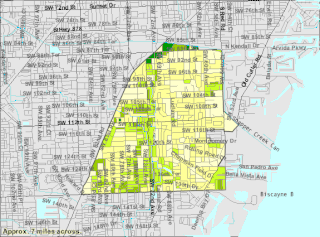
Little Havana is a neighborhood of Miami, Florida, United States. Home to many Cuban exiles, as well as many immigrants from Central and South America, Little Havana is named after Havana, the capital and largest city in Cuba.

Florida State Road 9 (SR 9) is a state road in the U.S. state of Florida. While SR 9 is mainly used as a state designation for Interstate 95 in Florida from the Golden Glades Interchange in Miami Gardens to the Georgia border, a signed SR 9, which is locally known in the Miami area as West 27th Avenue, Unity Boulevard, and historically Grapeland Boulevard, extends 13 miles (21 km) from the Coconut Grove section of Miami to the Golden Glades Interchange. The segment of I-95 south of the Golden Glades Interchange carries the designation of State Road 9A.
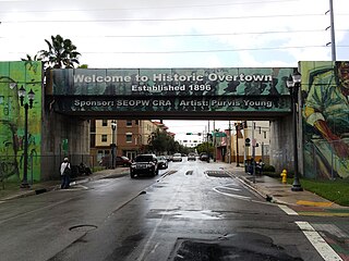
Overtown is a neighborhood of Miami, Florida, United States, just northwest of Downtown Miami. Originally called Colored Town in the Jim Crow era of the late 19th through the mid-20th century, the area was once the preeminent and is the historic center for commerce in the black community in Miami and South Florida.

State Road 933, locally known as West 12th Avenue, and Ronald W. Reagan Avenue, is a 4.25-mile (6.84 km) long north–south street entirely within the city limits of Miami, Florida. Its southern terminus is an intersection with Coral Way as Coral Way changes from Southwest 22nd Street to Southwest Third Avenue; its northern terminus is an interchange with the Airport Expressway. North of Dolphin Expressway, reassurance signage is virtually nonexistent, and the only indication of SR 933 existing north of Northwest 14th Street is a pair of trailblazer signs on Northwest 36th Street.

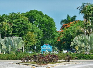
Palmetto Bay is a suburban incorporated village in Miami-Dade County, Florida, United States. Palmetto Bay includes two neighborhoods that were former census-designated places, Cutler and East Perrine. The village is part of the Miami metropolitan area of South Florida. The population was 24,439 as of the 2020 US census.

Coral Way, co-signed State Road 972 between Douglas Road and US 1 in Miami, is a 16.4-mile-long (26.4 km) primary east-west street that extends from Southwest 157th Avenue in western Miami-Dade County to Brickell Avenue in the Brickell neighborhood of Downtown Miami, Florida.
Brickell is a neighborhood in Miami, Florida, historically referenced at times as Southside, located directly east of Interstate 95, south of the Miami River, and north of Coconut Grove. Brickell is known as the financial district of Miami, as well as South Florida.
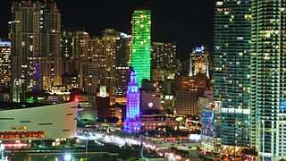
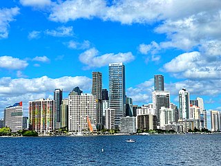
Downtown Miami is the urban city center of Miami, Florida, United States. The city's greater downtown region consists of the Central Business District, Brickell, the Historic District, Government Center, the Arts & Entertainment District, and Park West. It is divided by the Miami River and is bordered by Midtown Miami's Edgewater, and Wynwood sections to its north, Biscayne Bay to its east, the Health District and Overtown to its west, and Coconut Grove to its south.
The Roads is a neighborhood of Miami in Miami-Dade County, Florida. It is a triangular area located south of SW 11th Street, between SW 12th Avenue and SW 15th Road, just west of Brickell.
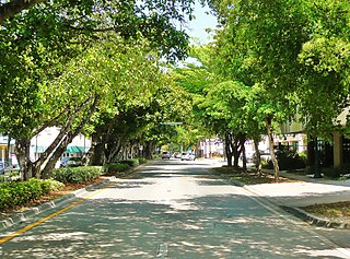
Coral Way is a neighborhood within Miami, Florida that is defined by Coral Way, a road established by Coral Gables founder George E. Merrick during the 1920s. It is located in Miami-Dade County, Florida.
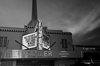
MDC's Tower Theater, is one of Miami's oldest cultural landmarks. When it opened in December 1926, it was the finest state-of-the-art theater in the South. It is located on SW Eighth Street and Fifteenth Avenue in Miami, Florida.

Riverside is a neighborhood in Miami, Florida, United States.
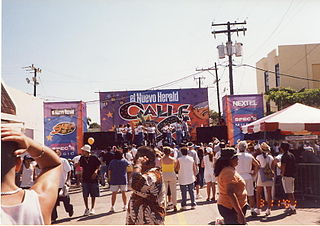
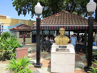
The Calle Ocho Music Festival is a one-day fiesta that culminates Carnaval Miami. It takes place in March in the Little Havana neighborhood of Miami, Florida, between SW 12th Avenue and 27th Avenue on SW 8th Street.


