Miami Springs is a city in Miami-Dade County, Florida, United States. The city is part of the Miami metropolitan area of South Florida. As of 2020, the population recorded by the U.S. Census Bureau was 13,859.

The Buffalo River drains a 447-square-mile (1,160 km2) watershed in Western New York state, emptying into the eastern end of Lake Erie at the City of Buffalo. The river has three tributaries: Cayuga Creek, Buffalo Creek, and Cazenovia Creek.

Rock Creek is a tributary of the Potomac River, in the United States, that empties into the Atlantic Ocean via the Chesapeake Bay. The 32.6-mile (52.5 km) creek drains about 76.5 square miles (198 km2). Its final quarter-mile is affected by tides.
The Greater Richmond, Virginia area has many neighborhoods and districts.

Florida State Road 9 (SR 9) is a state road in the U.S. state of Florida. While SR 9 is mainly used as a state designation for Interstate 95 in Florida from the Golden Glades Interchange in Miami Gardens to the Georgia border, a signed SR 9, which is locally known in the Miami area as West 27th Avenue, Unity Boulevard, and historically Grapeland Boulevard, extends 13 miles (21 km) from the Coconut Grove section of Miami to the Golden Glades Interchange. The segment of I-95 south of the Golden Glades Interchange carries the designation of State Road 9A.
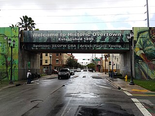
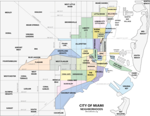
Overtown is a neighborhood of Miami, Florida, United States, just northwest of Downtown Miami. Originally called Colored Town in the Jim Crow era of the late 19th through the mid-20th century, the area was once the preeminent and is the historic center for commerce in the black community in Miami and South Florida. The Overtown Historic Folklife Village is in the area.

Arch Creek was an early settlement in Miami-Dade County, Florida, in present-day metropolitan Miami. Tequesta Indians thrived here before the first Europeans arrived in the early 16th century. The name is derived from the 40 feet (12 m) long natural limestone bridge that spanned the creek until 1973. It is part of the Arch Creek Memorial Park at 1855 Northeast 135th Street, on Biscayne Boulevard. It was added to the U.S. National Register of Historic Places on July 15, 1986.

There are more than 500 neighborhoods within the area of Jacksonville, Florida, the largest city in the contiguous United States by area. These include Downtown Jacksonville and surrounding neighborhoods. Additionally, greater Jacksonville is traditionally divided into several major sections with amorphous boundaries: Northside, Westside, Southside, and Arlington, as well as the Jacksonville Beaches.
The City of Oklahoma City uses Special Zoning Districts as a tool to maintain the character of many neighborhood communities.

Red Road, also known as West 57th Avenue, is a 20.6-mile (33.2 km) main north-south street running west of downtown Miami in Miami-Dade County, Florida and into Broward County. Red Road is signed as State Road 959 from U.S. 1 to the south end of the Miami International Airport, and State Road 823 from U.S. 27 to the Broward County line.
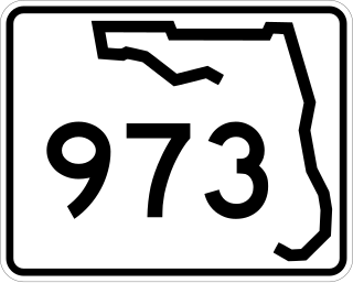
Galloway Road, also known as West 87th Avenue, is a north–south route through the western areas of suburban Miami-Dade County, Florida, from the Black Point area south of Cutler Bay almost to the Broward County line north of Miami Lakes. It exists in seven different unconnected segments that total 27.5 miles (44.3 km) in length, acting as connecting roads, neighborhood streets, and arterial routes. Approximately 9.5 miles (15.3 km) of Galloway Road, between Pinecrest and Doral, is designated as State Road 973.

The Lummus Park Historic District or simply Lummus Park, is on the National Register of Historic Places and a locally historic designated district in Miami, Florida. It is roughly bound by Northwest Fifth Street to the north, Flagler Street to the south, Northwest Third Avenue to the east, and the Miami River to the west. On October 25, 2006, it was added to the U.S. National Register of Historic Places. Lummus Park has some of the oldest structures in Miami, and over the decades, has been able to retain a large part of its early pioneer character.

The Upper Eastside is a neighborhood in Miami, Florida. It is north of Edgewater, east of Little Haiti, south of the village of Miami Shores, and sits on Biscayne Bay. In geographical order from south to north and east to west, it contains the subdivisions of Magnolia Park, Bay Point, Morningside, Bayside, Belle Meade, Shorecrest, and Palm Grove. The MiMo District along Biscayne Boulevard in the area is host to many art galleries, shops and restaurants.

Crane Creek is a 3.3-mile-long (5.3 km) stream in Melbourne, Florida, United States. It is a tributary of the Indian River, with its mouth in the vicinity of Front Street.

The New River is a tidal estuary in South Florida, United States. Despite its name, it is not a true natural river, but a channel composed of many tributary canals. The channel is connected to the Everglades through a series of man-made canals. After passing through Fort Lauderdale, the channel connects to the Intracoastal Waterway and Atlantic Ocean at Port Everglades cut. The channel is entirely within Broward County and is composed from the junction of three main canals which originate in the Everglades, splitting off from the Miami Canal. They are the North New River Canal, which flows south from Lake Okeechobee along the east side of U.S. 27 and then east along the north side of State Road 84 / Interstate 595; the South New River Canal, which flows east from the Miami Canal along the north side of Griffin Road and the south side of Orange Drive; and a canal which flows east along the south side of Sunrise Boulevard. The Henry E. Kinney Tunnel in downtown Fort Lauderdale travels underneath the New River.
Lakeshore/Lake Vista is a neighborhood of the city of New Orleans, Louisiana. A subdistrict of the Lakeview District Area, its boundaries as defined by the City Planning Commission are: Lake Pontchartrain to the north, Bayou St. John to the east, Allen Toussaint Boulevard to the south and Pontchartrain Boulevard and the New Basin Canal to the west. The neighborhood is composed of the Lakeshore and Lake Vista subdivisions, built on land reclaimed from Lake Pontchartrain. The Lakefront is a term sometimes used to name the larger neighborhood created by the Orleans Levee Board's land reclamation initiative in early 20th century New Orleans; it includes Lakeshore and Lake Vista, as well as Lakeshore Drive and the lakefront park system, the University of New Orleans, Lake Terrace, and Lake Oaks.
Dobyville was a historic black neighborhood in what is now West Hyde Park, Tampa, Florida. It was named for Richard Cornelius Doby, a resident philanthropic black businessman and community leader.
The Chain of Lakes is a famous series of lakes in Central Florida. There are two chains of lakes, the northern chain and the southern chain. The northern chain extends across three cities: Winter Haven, Lake Alfred, and Lake Hamilton. It has ten lakes, connected by a series of canals. The ten lakes on the northern chain are Lake Haines, Lake Rochelle, Lake Echo, Lake Conine, Lake Fannie, Lake Smart, Lake Henry, Lake Hamilton, Middle Lake Hamilton, and Little Lake Hamilton.

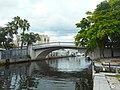
Wagner Creek is a tributary of the Miami River in Miami, Florida, that drains out of the Biscayne Aquifer in what used to be the Allapatah prairie and runs through the city of Miami neighborhoods of Allapatah, Spring Garden and Overtown.