Coral Way

Last updated
Coral Way in Coral Gables, Florida, April 2010 Coral Way Miami 20100430.jpg
Coral Way in Coral Gables, Florida, April 2010

Coral Way is a neighborhood within Miami, Florida that is defined by Coral Way, a road established by Coral Gables founder George E. Merrick during the 1920s. It is located in Miami-Dade County, Florida.

Contents

The Coral Way neighborhood is served by the Miami Metrorail at Vizcaya (South Dixie Highway/US 1 and West First Avenue) and Coconut Grove stations (US 1 and West 27th Avenue/SR 9).

History

The architecture in the Coral Way neighborhoods reflects the early-20th century. Some of the older sections contain a mixture of Mission Revival Style architecture and bungalow homes of the 1920s, along with the Art Deco style from the 1930s and the modest post-World War II dwellings.

The Coral Way area is best known for its historic urban boulevard along SW 22nd Street (Coral Way). One of the main thoroughfares between Coral Gables and the City of Miami, Coral Way passes through the City of Miami between SW 37th Avenue and Brickell Avenue. The Coral Way Corridor began in 1922 with citrus lined streets; later growing to have streetcar tracks down the center of the road, connecting Downtown Miami to Coral Gables. In 1929, a Roadside Beautification Program was started, and 1,200 banyan trees were planted along the median of the boulevard. Today, Coral Way remains one of the more beautiful corridors in South Florida. [1]

Geography

The sub-neighborhoods within Coral Way include: Shenandoah, Silver Bluff, Vizcaya-Roads, Coral Gate, Parkdale-Lyndale, South Miami, Bryan Park, and Golden Pines.

Coral Gate

Coral Gate is a smaller sub-neighborhood within the larger Coral Way neighborhood. It is roughly located south of SW 16th Street, east of SW 37th Avenue, north of Coral Way and west of SW 32nd Avenue. Coral Gate borders Coral Gables to the west and Golden Pines to the south. The north and east boundaries of Coral Gate are enclosed by walls or street barriers with all vehicles blocked from entering or exiting through these directions.

Golden Pines

Golden Pines is a smaller sub-neighborhood within the larger Coral Way neighborhood. It is located east of Coral Gables], bound by SW 22 St (north), South Dixie Highway. (south), 27 Ave (east) and 37 Ave (west). It is located at 25°44′02″N80°14′31″W / 25.734°N 80.242°W / 25.734; -80.242 , with an elevation 10 feet (3.0 m). [2]

Shenandoah

Shenandoah is an important neighborhood in Miami, boasting a large number of houses from the 1920s and 1930s and rich in revivalist Architecture . It is located directly south of Little Havana, between SW 9th (north) Street and Coral Way (south), SW 27th Avenue (west) and SW 12th Avenue (east). It is located at 25°45′36″N80°13′19″W / 25.76°N 80.222°W / 25.76; -80.222 , with an elevation 10 feet (3.0 m). [3]

Silver Bluff

Silver Bluff is a smaller sub-neighborhood within the larger Coral Way neighborhood. It is located south of Coral Way (SW 22nd Street), west of SW 17th Avenue, east of SW 27th Avenue and north of South Dixie Highway. Much of this territory was the "City of Silver Bluff", which was annexed into the City of Miami in 1926. It is located at 25°44′56″N80°14′10″W / 25.749°N 80.236°W / 25.749; -80.236 , with an elevation 10 feet (3.0 m). [4]

Demographics

As of 2000, [5] Coral Way had a population of 55,951 and 69,041 [6] residents, with 21,363 households, and 14,105 families residing in the city. The median household income was $37,168.89. The racial makeup of the neighborhood was 81.10% Hispanic or Latino of any race, 0.41% Black or African American, 17.28% White (non-Hispanic), and 1.21% other races (non-Hispanic).

The zip codes for Coral Way include 33129, 33133, 33135, and 33145. The area covers 6.697 square miles (17.35 km2). As of 2000, there were 32,879 males and 36,162 females. The median age for males were 38.6 years old, while the median age for females were 43.3 years old. The average household size had 2.5 people, while the average family size had 3.1 members. The percentage of married-couple families (among all households) was 42.3%, while the percentage of married-couple families with children (among all households) was 15.7%, and the percentage of single-mother households (among all households) was 7.1%. The percentage of never-married males 15 years old and over was 14.6%, while the percentage of never-married females 15 years old and over was 12.1%. [6]

As of 2000, the percentage of people that speak English not well or not at all made up 35.8% of the population. The percentage of residents born in Florida was 19.4%, the percentage of people born in another U.S. state was 8.1%, and the percentage of native residents but born outside the U.S. was 2.1%; the percentage of foreign-born residents was 70.4%. [6]

Coral Way with St. Sophia Orthodox Church Coral Way with St Sophia Greek Orthodox Church.jpg
Coral Way with St. Sophia Orthodox Church

Economy

The Consulate-General of Costa Rica in Miami is located in Suite 401 at 2730 SW 3rd Avenue in Coral Way. [7]

Transportation

Coral Way is served by Metrobus throughout the area, and by the Miami Metrorail at:

Education

Miami-Dade County Public Schools operates area public schools:

Public schools

Elementary schools

  • Silver Bluff Elementary School
  • Frances S. Tucker Elementary School
  • Coral Way K-8 Center
  • Merrick Educational Center

Middle schools

  • Coral Way K-8 Center

Adult education

  • The English Center

Private schools

Parks

Related Research Articles

<span class="mw-page-title-main">Coral Gables, Florida</span> City in Miami-Dade County, Florida

Coral Gables is a city in Miami-Dade County, Florida, United States. The city is part of the Miami metropolitan area of South Florida and is located 7 miles (11 km) southwest of Downtown Miami. As of the 2020 U.S. census, it had a population of 49,248.

<span class="mw-page-title-main">Coral Terrace, Florida</span> Census-designated place in Florida

Coral Terrace is a suburban unincorporated community and census-designated place (CDP) in Miami-Dade County, Florida, United States. It is part of the Miami metropolitan area of South Florida. The population was 23,142 at the 2020 census, down from 24,376 in 2010.

<span class="mw-page-title-main">Gladeview, Florida</span> Census-designated place in Florida

Gladeview is a census-designated place (CDP) in Miami-Dade County, Florida, United States. It is part of the Miami metropolitan area of South Florida. The population was 14,927 at the 2020 census, up from 11,535 in 2010.

<span class="mw-page-title-main">Glenvar Heights, Florida</span> Census-designated place in Florida

Glenvar Heights is a census-designated place (CDP) and neighborhood in Miami-Dade County, Florida, United States. It is part of the Miami metropolitan area of South Florida. The population was 20,786 at the 2020 US census, up from 16,898 in 2010 US census.

<span class="mw-page-title-main">Kendale Lakes, Florida</span> Census-designated place in Florida

Kendale Lakes is a census-designated place (CDP) and a suburb of Miami in Miami-Dade County, Florida, United States. It is located in the Miami metropolitan area of South Florida. The population was 55,646 at the 2020 census.

<span class="mw-page-title-main">South Miami, Florida</span> City in Florida

South Miami is a city in Miami-Dade County, Florida, United States. The city is part of the Miami metropolitan area of South Florida. The population was 12,026 as of the 2020 census.

<span class="mw-page-title-main">Tamiami, Florida</span> Census-designated place in Florida

Tamiami is a census-designated place (CDP) in Miami-Dade County, Florida, United States. It is part of the Miami metropolitan area of South Florida. The population was 54,212 at the 2020 census.

<span class="mw-page-title-main">West Miami, Florida</span> City in Florida, United States

West Miami is a city in Miami-Dade County, Florida, United States. The city is part of the Miami metropolitan area of South Florida. The population was 7,233 at the 2020 census, up from 5,965 in 2010.

<span class="mw-page-title-main">Westchester, Florida</span> Census-designated place in Florida, United States

Westchester is a census-designated place (CDP) and neighborhood in Miami-Dade County, Florida. Prior to the 2020 U.S. Census, the neighboring University Park CDP was merged into Westchester CDP, effectively doubling its geography and population. Per the 2020 census, the population was 56,384.

<span class="mw-page-title-main">Coconut Grove</span> Neighborhood of Miami, Florida, United States

Coconut Grove, also known colloquially as The Grove, is an affluent and the oldest continuously inhabited neighborhood of Miami in Miami-Dade County, Florida. The neighborhood is roughly bounded by North Prospect Drive to the south, LeJeune Road to the west, South Dixie Highway and Rickenbacker Causeway to the north, and Biscayne Bay to the east. It is south of the neighborhoods of Brickell and The Roads and east of Coral Gables. The neighborhood's name has been sometimes spelled "Cocoanut Grove" but the definitive spelling "Coconut Grove" was established when the city was incorporated in 1919.

<span class="mw-page-title-main">Little Havana</span> Neighborhood of Miami in Miami-Dade, Florida, United States

Little Havana is a neighborhood of Miami, Florida, United States. Home to many Cuban exiles, as well as many immigrants from Central and South America, Little Havana is named after Havana, the capital and largest city in Cuba.

<span class="mw-page-title-main">Allapattah</span> Neighborhood of Miami in Miami-Dade County, Florida, United States

Allapattah is a neighborhood, located mostly in the city of Miami, Florida in metropolitan Miami. As of May 2011, the county-owned portion of Allapattah, from State Road 9 to LeJeune Road, is being annexed by the city proper.

<span class="mw-page-title-main">Florida State Road 9</span> State highway in Florida, United States

Florida State Road 9 (SR 9) is a state road in the U.S. state of Florida. While SR 9 is mainly used as a state designation for Interstate 95 in Florida from the Golden Glades Interchange in Miami Gardens to the Georgia border, a signed SR 9, which is locally known in the Miami area as West 27th Avenue, Unity Boulevard, and historically Grapeland Boulevard, extends 13 miles (21 km) from the Coconut Grove section of Miami to the Golden Glades Interchange. The segment of I-95 south of the Golden Glades Interchange carries the designation of State Road 9A.

<span class="mw-page-title-main">Liberty City (Miami)</span> Neighbourhood in Miami, Florida, US

Liberty City is a neighborhood in Miami, Florida, United States. The area is roughly bound by NW 79th Street to the north, NW 27th Avenue to the west, the Airport Expressway to the South, and Interstate 95 to the east. The neighborhood is home to one of the largest concentrations of African Americans in South Florida, as of the 2000 census. Although it was often known as "Model City" both historically and by the City of Miami government, residents more commonly call it Liberty City.

<span class="mw-page-title-main">Flagami</span> Neighborhood of Miami in Miami-Dade County, Florida, United States

Flagami is a neighborhood of Miami, Florida, United States, roughly defined as south and east of the Tamiami Canal, north of the Tamiami Trail, and west of Red Road, bisected by Flagler Street.

<span class="mw-page-title-main">Palmetto Bay, Florida</span> Village in Florida

Palmetto Bay is a suburban incorporated village in Miami-Dade County, Florida, United States. Palmetto Bay includes two neighborhoods that were former census-designated places, Cutler and East Perrine. The village is part of the Miami metropolitan area of South Florida. The population was 24,439 as of the 2020 US census.

<span class="mw-page-title-main">Coral Way (street)</span>

Coral Way, co-signed State Road 972 between Douglas Road and US 1 in Miami, is a 16.4-mile-long (26.4 km) primary east-west street that extends from Southwest 157th Avenue in western Miami-Dade County to Brickell Avenue in the Brickell neighborhood of Downtown Miami, Florida.

<span class="mw-page-title-main">Brickell</span> Neighborhood of Miami in Miami-Dade County, Florida, United States

Brickell is a neighborhood in Miami, Florida located directly east of Interstate 95, south of the historic CBD, and north of Coconut Grove. Brickell is known as the financial district of Miami, as well as South Florida.

<span class="mw-page-title-main">Buena Vista (Miami)</span> Neighborhood of Miami in Miami-Dade County, Florida, United States

Buena Vista is a neighborhood in Miami, Florida, United States. It is located south of Little Haiti, north of the Miami Design District.

<span class="mw-page-title-main">The Roads</span> Neighborhood of Miami in Miami-Dade County, Florida, United States

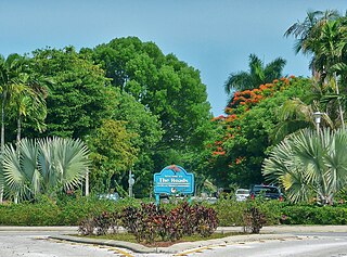
The Roads is a neighborhood of Miami in Miami-Dade County, Florida. It is a triangular area located south of SW 11th Street, between SW 12th Avenue and SW 15th Road, just west of Brickell.

References

  1. City of Miami-Neighborhood Enhancement Teams Archived 2013-09-21 at the Wayback Machine
  2. FL Community Profile
  3. Shenandoah, FL Community Profile
  4. Silver Bluff Estates, FL Community Profile
  5. "Demographics of Coral Way Miami, FL". miamigov.com. Archived from the original on 2008-05-17. Retrieved 2008-06-11.
  6. 1 2 3 "Demographics of Coral Way, Miami, Florida". city-data . Retrieved 2009-08-28.
  7. "Consulates in the United States Archived January 23, 2009, at the Wayback Machine ." Embassy of Costa Rica in Washington D.C. Retrieved on January 31, 2009.

25°45′N80°17′W / 25.750°N 80.283°W / 25.750; -80.283