Three Lakes, Florida | |
---|---|
Coordinates: 25°38′7″N80°23′57″W / 25.63528°N 80.39917°W | |
Country | United States of America |
State | Florida |
County | Miami-Dade |
Area | |
• Total | 3.90 sq mi (10.09 km2) |
• Land | 3.23 sq mi (8.36 km2) |
• Water | 0.67 sq mi (1.73 km2) |
Elevation | 7 ft (2 m) |
Population | |
• Total | 16,540 |
• Density | 5,125.50/sq mi (1,979.16/km2) |
Time zone | UTC-5 (Eastern (EST)) |
• Summer (DST) | UTC-4 (EDT) |
ZIP Code | 33186 (Miami) |
Area code(s) | 305, 786, 645 |
FIPS code | 12-71741 [3] |
GNIS feature ID | 1853294 [4] |
Three Lakes is a census-designated place (CDP) and planned community in Miami-Dade County, Florida, United States. It is part of the Miami metropolitan area of South Florida. The population was 16,540 at the 2020 census, [2] up from 15,047 in 2010. [5]
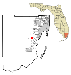
Three Lakes is located 16 miles (26 km) southwest of downtown Miami at 25°38′7″N80°23′57″W / 25.63528°N 80.39917°W (25.635372, -80.399031). [6] It is bordered to the north by The Crossings, to the northeast by Kendall, to the east by Richmond Heights, to the south by Zoo Miami, and to the west by Country Walk. The Hammocks touches the northwest corner of Three Lakes, and Palmetto Estates touches the southeast corner.
According to the United States Census Bureau, the Three Lakes CDP has a total area of 3.9 square miles (10 km2), of which 3.2 square miles (8.3 km2) are land and 0.7 square miles (1.8 km2), or 17.17%, are water. [1]
The three main neighborhoods in the Three Lakes CDP are Deerwood, Bonita Lakes, and Three Lakes (its namesake).
Three Lakes has a handful of churches, schools, and strip malls scattered around.
Census | Pop. | Note | %± |
---|---|---|---|
2000 | 6,955 | — | |
2010 | 15,047 | 116.3% | |
2020 | 16,540 | 9.9% | |
U.S. Decennial Census [7] |
Race / Ethnicity (NH = Non-Hispanic) | Pop 2010 [8] | Pop 2020 [9] | % 2010 | % 2020 |
---|---|---|---|---|
White (NH) | 2,805 | 2,192 | 18.64% | 13.25% |
Black or African American (NH) | 1,388 | 1,050 | 9.22% | 6.35% |
Native American or Alaska Native (NH) | 8 | 13 | 0.05% | 0.08% |
Asian (NH) | 667 | 717 | 4.43% | 4.33% |
Pacific Islander or Native Hawaiian (NH) | 7 | 4 | 0.05% | 0.02% |
Some other race (NH) | 80 | 131 | 0.53% | 0.79% |
Mixed race or Multiracial (NH) | 249 | 466 | 1.65% | 2.82% |
Hispanic or Latino (any race) | 9,843 | 11,967 | 65.42% | 72.35% |
Total | 15,047 | 16,540 | 100.00% | 100.00% |
As of the 2020 United States census, there were 16,540 people, 4,736 households, and 3,813 families residing in the CDP. [10]
As of the 2010 United States census, there were 15,047 people, 4,726 households, and 3,606 families residing in the CDP. [11]
As of the census [3] of 2000, there were 6,955 people, 2,463 households, and 1,889 families residing in the CDP. The population density was 2,131.4 inhabitants per square mile (822.9/km2). There were 2,627 housing units at an average density of 805.1 per square mile (310.9/km2). The racial makeup of the CDP was 72.49% White (31.6% were Non-Hispanic White), [12] 15.64% African American, 0.12% Native American, 3.87% Asian, 0.01% Pacific Islander, 4.10% from other races, and 3.77% from two or more races. Hispanic or Latino of any race were 47.76% of the population.
As of 2000, there were 2,463 households, out of which 44.8% had children under the age of 18 living with them, 56.4% were married couples living together, 15.8% had a female householder with no husband present, and 23.3% were non-families. 16.9% of all households were made up of individuals, and 2.1% had someone living alone who was 65 years of age or older. The average household size was 2.82 and the average family size was 3.19.
In 2000, in the CDP, the population was spread out, with 28.3% under the age of 18, 9.4% from 18 to 24, 40.8% from 25 to 44, 16.1% from 45 to 64, and 5.4% who were 65 years of age or older. The median age was 31 years. For every 100 females, there were 90.4 males. For every 100 females age 18 and over, there were 85.5 males.
In 2000, the median income for a household in the CDP was $54,830, and the median income for a family was $58,424. Males had a median income of $37,194 versus $30,481 for females. The per capita income for the CDP was $22,832. About 6.7% of families and 8.0% of the population were below the poverty line, including 8.0% of those under age 18 and 13.8% of those age 65 or over.
As of 2000, speakers of Spanish as a first language accounted for 51.87% of residents, while English made up 45.19%, and French was the mother tongue of 2.92% of the population. [13]
Goulding is a census-designated place (CDP) in Escambia County, Florida, United States. The population was 3,392 at the 2020 census, down from 4,102 at the 2010 census. It is part of the Pensacola–Ferry Pass–Brent, Florida Metropolitan Statistical Area.
Egypt Lake-Leto is a census-designated place (CDP) in an unincorporated part of Hillsborough County, Florida, United States. The CDP is located just north of Tampa International Airport. It is part of the Tampa Bay area. As of the 2020 US census, the population had 36,644 residents.
Lake Magdalene is a census-designated place (CDP) in Hillsborough County, Florida, United States. It is part of the Tampa Bay area. The population was 30,742 at the 2020 census.
University is an unincorporated census-designated place in Hillsborough County, Florida, United States. The population was 41,163 at the 2010 census, up from 30,736 at the 2000 census. The University of South Florida is located just southeast of the community, within the Tampa city limits. The community is also known as "University West", mainly due to its location in relation to the university. The community is often notoriously referred to by locals as "Suitcase City" due to the high rate of transients.
Charleston Park is an unincorporated community and census-designated place (CDP) in Lee County, Florida, United States. The population was 235 at the 2020 census, up from 218 at the 2010 census. It is part of the Cape Coral-Fort Myers, Florida Metropolitan Statistical Area.
Country Club is a suburban census-designated place located in northwest Miami-Dade County, Florida, United States. It is located in the Miami metropolitan area of South Florida. The CDP is named after the Country Club of Miami, which was established in 1961 in what was then an unpopulated and undeveloped section of the county. The population was 49,967 at the 2020 census, up from 3,408 in 1990.
Glenvar Heights is a census-designated place (CDP) and neighborhood in Miami-Dade County, Florida, United States. It is part of the Miami metropolitan area of South Florida. The population was 20,786 at the 2020 US census, up from 16,898 in 2010 US census.
Kendall West is a census-designated place and unincorporated community in Miami-Dade County, Florida, west of the Florida Turnpike. It is located in the Miami metropolitan area of South Florida. The population was 36,536 at the 2020 census.
Olympia Heights is a census-designated place in Miami-Dade County, Florida, United States. It is located in the Miami metropolitan area of South Florida. The population was 12,873 at the 2020 census.
Palm Springs North is an unincorporated community and census-designated place (CDP) in Miami-Dade County, Florida, United States. It is part of the Miami metropolitan area of South Florida. The population was 5,030 at the 2020 census.
Pinewood is an unincorporated community and census-designated place (CDP) in Miami-Dade County, Florida, United States. It is part of the Miami metropolitan area of South Florida. The population was 17,246 at the 2020 census.
Richmond Heights is a census-designated place (CDP) in Miami-Dade County, Florida, United States. It is part of the Miami metropolitan area of South Florida. The population was 8,944 at the 2020 census.
Sunset is a census-designated place (CDP) in Miami-Dade County, Florida, United States. It is part of the Miami metropolitan area of South Florida. The population was 15,912 at the 2020 census. The U.S. Postal Service uses the ZIP Codes of 33173 and 33183 for Sunset.
The Crossings is a census-designated place (CDP) and suburb of Miami in Miami-Dade County, Florida, United States. It is part of the Miami metropolitan area of South Florida. The CDP includes the neighborhoods of The Crossings, Devon Aire, and Calusa. The population was 23,276 at the 2020 census.
West Little River is a census-designated place (CDP) in Miami-Dade County, Florida, United States. It is part of the Miami metropolitan area of South Florida. The population was 34,128 at the 2020 census.
West Perrine is a census-designated place (CDP) in Miami-Dade County, Florida, United States. It is part of the Miami metropolitan area of South Florida. The population was 10,602 at the 2020 census, up from 9,460 in 2010.
Westwood Lakes is a census-designated place and unincorporated community of Miami-Dade County, Florida, United States. It is part of the Miami metropolitan area of South Florida. The population was 11,373 at the 2020 census.
Carrollwood is a census-designated place (CDP) in northwestern Hillsborough County, Florida, United States. The census area includes the unincorporated communities of Carrollwood and Carrollwood Village. For the 2000 census the area was enumerated under the name "Greater Carrollwood". A similar area was listed as "Lake Carroll" in 1970 and 1980; for the 1990 census it was split into the smaller Carrollwood and Carrollwood Village CDPs. The population was 34,352 at the 2020 census.
South Miami Heights is a census-designated place (CDP), originally known as Eureka, in Miami-Dade County, Florida. It is part of the Miami metropolitan area of South Florida. The population was 36,770 as of the 2020 census.
Alafaya is a census-designated place and unincorporated area in Orange County, Florida, United States. The population was 92,452 at the 2020 US census. It is part of the Orlando–Kissimmee–Sanford, Florida Metropolitan Statistical Area. It is most known for being near the University of Central Florida, Avalon Park and Waterford Lakes.