Princeton, Florida | |
---|---|
Coordinates: 25°32′8″N80°23′51″W / 25.53556°N 80.39750°W | |
Country | United States of America |
State | Florida |
County | Miami-Dade |
Area | |
• Total | 7.47 sq mi (19.34 km2) |
• Land | 7.42 sq mi (19.21 km2) |
• Water | 0.05 sq mi (0.13 km2) |
Elevation | 10 ft (3 m) |
Population | |
• Total | 39,308 |
• Density | 5,299.72/sq mi (2,046.13/km2) |
Time zone | UTC-5 (Eastern (EST)) |
• Summer (DST) | UTC-4 (EDT) |
ZIP codes | 33032, 33092 (Princeton); 33170 (Goulds) |
Area code(s) | 305, 786, 645 |
FIPS code | 12-58975 [3] |
GNIS feature ID | 0289323 [4] |
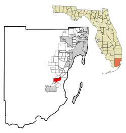
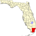
Princeton is a census-designated place (CDP) and unincorporated community in Miami-Dade County, Florida, United States. It is part of the Miami metropolitan area of South Florida. The population was 39,208 at the 2020 census, [2] up from 22,038 at the 2010 census.
As a small town and depot along the Florida East Coast Railroad in the 1900s, the community was named by Gaston Drake after his alma mater, Princeton University. Many of the town buildings were even painted the school's colors: black and orange. Drake operated a saw mill and lumber company in Princeton supplying Miami, the Florida Keys and Cuba until the local timber gave out in 1923. [5]
Princeton is located 24 miles (39 km) southwest of downtown Miami and 6 miles (10 km) northeast of Homestead at 25°32′8″N80°23′51″W / 25.53556°N 80.39750°W (25.535634, -80.397485). [6] It is bordered to the north by Goulds and to the southwest by Naranja, both unincorporated.
U.S. Route 1 (Dixie Highway) runs northeast to southwest through Princeton, and the Homestead Extension of Florida's Turnpike forms the eastern edge of the community, with access from Exit 9 (Florida State Road 989).
According to the United States Census Bureau, the CDP has a total area of 7.5 square miles (19 km2), of which 0.05 square miles (0.13 km2), or 0.67%, are water. [1]
Census | Pop. | Note | %± |
---|---|---|---|
1960 | 1,719 | — | |
1990 | 7,073 | — | |
2000 | 10,090 | 42.7% | |
2010 | 22,038 | 118.4% | |
2020 | 39,308 | 78.4% | |
source: [7] [8] [9] [10] |
Race / Ethnicity (NH = Non-Hispanic) | Pop 2010 [11] | Pop 2020 [12] | % 2010 | % 2020 |
---|---|---|---|---|
White (NH) | 1,857 | 2,724 | 8.43% | 6.93% |
Black or African American (NH) | 6,165 | 7,001 | 27.97% | 17.81% |
Native American or Alaska Native (NH) | 26 | 22 | 0.12% | 0.06% |
Asian (NH) | 297 | 574 | 1.35% | 1.46% |
Pacific Islander or Native Hawaiian (NH) | 10 | 3 | 0.05% | 0.01% |
Some other race (NH) | 49 | 209 | 0.22% | 0.53% |
Mixed race or Multiracial (NH) | 218 | 630 | 0.99% | 1.60% |
Hispanic or Latino (any race) | 13,416 | 28,145 | 60.88% | 71.60% |
Total | 22,038 | 39,308 | 100.00% | 100.00% |
As of the 2020 United States census, there were 39,308 people, 8,356 households, and 7,058 families residing in the CDP. [13]
As of the 2010 United States census, there were 22,038 people, 5,688 households, and 4,807 families residing in the CDP. [14]
As of the census [3] of 2000, there were 10,090 people, 2,732 households, and 2,341 families residing in the CDP. The population density was 1,373.3 inhabitants per square mile (530.2/km2). There were 2,906 housing units at an average density of 395.5 per square mile (152.7/km2). The racial makeup of the CDP was 53.78% White (18% were Non-Hispanic White), [15] 32.54% African American, 0.34% Native American, 1.37% Asian, 0.06% Pacific Islander, 7.70% from other races, and 4.22% from two or more races. Hispanic or Latino of any race were 47.49% of the population.
As of 2000, there were 2,732 households, out of which 52.4% had children under the age of 18 living with them, 56.8% were married couples living together, 22.4% had a female householder with no husband present, and 14.3% were non-families. 10.0% of all households were made up of individuals, and 2.3% had someone living alone who was 65 years of age or older. The average household size was 3.63 and the average family size was 3.85.
In 2000, in the CDP, the population was spread out, with 36.1% under the age of 18, 10.2% from 18 to 24, 30.0% from 25 to 44, 17.7% from 45 to 64, and 6.0% who were 65 years of age or older. The median age was 28 years. For every 100 females, there were 97.0 males. For every 100 females age 18 and over, there were 92.6 males.
In 2000, the median income for a household in the CDP was $39,556, and the median income for a family was $41,896. Males had a median income of $32,101 versus $23,634 for females. The per capita income for the CDP was $12,918. About 19.8% of families and 23.8% of the population were below the poverty line, including 33.1% of those under age 18 and 14.4% of those age 65 or over.
As of 2000, speakers of English as a first language accounted for 50.02% of residents; Spanish made up 49.24%, and French Creole was the first language for 0.72% of the population. [16]
Coral Terrace is a suburban unincorporated community and census-designated place (CDP) in Miami-Dade County, Florida, United States. It is part of the Miami metropolitan area of South Florida. The population was 23,142 at the 2020 census, down from 24,376 in 2010.
Biscayne Gardens is a census-designated place (CDP) in Miami-Dade County, Florida, United States. It is part of the Miami metropolitan area of South Florida. The population was 32,499 at the 2020 US census.
Goulds is an unincorporated community and census-designated place (CDP) in Miami-Dade County, Florida, United States. The area was originally populated as the result of a stop on the Florida East Coast Railroad. The railroad depot was located near the current Southwest 224th Street. The community was named after its operator, Lyman Gould, who cut trees for railroad ties. It is part of the Miami metropolitan area of South Florida. As of the 2020 US census, the population stood at 11,446, up from 10,103 in 2010 US census.
Ives Estates is a census-designated place (CDP) in Miami-Dade County, Florida. It is part of the Miami metropolitan area of South Florida. The population was 25,005 at the 2020 census, up from 19,525 in 2010.
Kendall West is a census-designated place and unincorporated community in Miami-Dade County, Florida, west of the Florida Turnpike. It is located in the Miami metropolitan area of South Florida. The population was 36,536 at the 2020 census.
Leisure City is an unincorporated community and census-designated place (CDP) in Miami-Dade County, Florida, United States, that includes the smaller, older community of Modello in its northwestern section. The CDP is most notable for the Coral Castle Museum, located in the Modello area. It is located in the Miami metropolitan area of South Florida. The population was 26,324 at the 2020 census, up from 22,655 in 2010.
Naranja is an unincorporated community and census-designated place (CDP) in Miami-Dade County, Florida, United States. Many orange groves were once located in this area, so the community name came from the Spanish word for orange, naranja, though the pronunciation among the local residents is "Na-Ran-Jah". Naranja was also a stop for the Florida East Coast Railroad that once ran through this area. It is part of the Miami metropolitan area of South Florida. The population was 13,509 at the 2020 census, up from 8,303 in 2010.
Olympia Heights is a census-designated place in Miami-Dade County, Florida, United States. It is located in the Miami metropolitan area of South Florida. The population was 12,873 at the 2020 census.
Palm Springs North is an unincorporated community and census-designated place (CDP) in Miami-Dade County, Florida, United States. It is part of the Miami metropolitan area of South Florida. The population was 5,030 at the 2020 census.
Palmetto Estates is an unincorporated area and census-designated place (CDP) in Miami-Dade County, Florida, United States. It is part of the Miami metropolitan area of South Florida. The population was 13,498 at the 2020 census.
Pinewood is an unincorporated community and census-designated place (CDP) in Miami-Dade County, Florida, United States. It is part of the Miami metropolitan area of South Florida. The population was 17,246 at the 2020 census.
Richmond Heights is a census-designated place (CDP) in Miami-Dade County, Florida, United States. It is part of the Miami metropolitan area of South Florida. The population was 8,944 at the 2020 census.
Richmond West is a census-designated place (CDP) in Miami-Dade County, Florida, United States. It is part of the Miami metropolitan area of South Florida. The population was 35,884 at the 2020 census, up from 31,973 at the 2010 census.
Sunset is a census-designated place (CDP) in Miami-Dade County, Florida, United States. It is part of the Miami metropolitan area of South Florida. The population was 15,912 at the 2020 census. The U.S. Postal Service uses the ZIP Codes of 33173 and 33183 for Sunset.
The Crossings is a census-designated place (CDP) and suburb of Miami in Miami-Dade County, Florida, United States. It is part of the Miami metropolitan area of South Florida. The CDP includes the neighborhoods of The Crossings, Devon Aire, and Calusa. The population was 23,276 at the 2020 census.
The Hammocks is a planned community and census-designated place in Miami-Dade County, Florida, United States. It is part of the Miami metropolitan area of South Florida. The population was 59,480 at the 2020 census, up from 51,003 in 2010.
Three Lakes is a census-designated place (CDP) and planned community in Miami-Dade County, Florida, United States. It is part of the Miami metropolitan area of South Florida. The population was 16,540 at the 2020 census, up from 15,047 in 2010.
West Perrine is a census-designated place (CDP) in Miami-Dade County, Florida, United States. It is part of the Miami metropolitan area of South Florida. The population was 10,602 at the 2020 census, up from 9,460 in 2010.
Westwood Lakes is a census-designated place and unincorporated community of Miami-Dade County, Florida, United States. It is part of the Miami metropolitan area of South Florida. The population was 11,373 at the 2020 census.
South Miami Heights is a census-designated place (CDP), originally known as Eureka, in Miami-Dade County, Florida. It is part of the Miami metropolitan area of South Florida. The population was 36,770 as of the 2020 census.