Gladeview, Florida

Last updated

Gladeview, Florida
Miami-Dade County Florida Incorporated and Unincorporated areas Gladeview Highlighted.svg
Location in Miami-Dade County and the state of Florida
Gladeview.gif
U.S. Census Bureau map showing CDP boundaries
Coordinates: 25°50′24″N80°14′8″W / 25.84000°N 80.23556°W / 25.84000; -80.23556
Country Flag of the United States.svg  United States of America
State Flag of Florida.svg  Florida
County Flag of Miami-Dade County, Florida.png Miami-Dade
Area
[1]
  Total2.56 sq mi (6.64 km2)
  Land2.56 sq mi (6.63 km2)
  Water0.01 sq mi (0.01 km2)
Elevation
10 ft (3 m)
Population
 (2020) [2]
  Total14,927
  Density5,800/sq mi (2,200/km2)
Time zone UTC-5 (Eastern (EST))
  Summer (DST) UTC-4 (EDT)
ZIP Codes
33147, 33150 (Miami)
Area code(s) 305, 786, 645
FIPS code 12-25987 [3]
GNIS feature ID1867144 [4]

Gladeview is a census-designated place (CDP) in Miami-Dade County, Florida, United States. It is part of the Miami metropolitan area of South Florida. The population was 14,927 at the 2020 census, [2] up from 11,535 in 2010.

Contents

Gladeview was originally a neighborhood of the city of Miami when it was annexed in 1925. [5] With the arrival of the Great Depression, Miami gave up its jurisdiction and Gladeview became an unincorporated area of Miami-Dade County. [5]

Geography

Gladeview is located 7 miles (11 km) northwest of downtown Miami at 25°50′24″N80°14′8″W / 25.84000°N 80.23556°W / 25.84000; -80.23556 (25.839874, -80.235645). [6] Gladeview is bordered by Brownsville to the south, the Miami neighborhood of Liberty City to the east, and West Little River to the north. The city of Hialeah is located to the west of Gladeview.

According to the United States Census Bureau, the CDP has a total area of 2.6 square miles (6.7 km2), of which 0.005 square miles (3 acres), or 0.19%, are water. [1]

Demographics

Historical population
CensusPop.Note
1980 18,919
1990 15,637−17.3%
2000 14,468−7.5%
2010 11,535−20.3%
2020 14,92729.4%
U.S. Decennial Census [7]

2010 and 2020 census

Gladeview CDP – Racial and Ethnic Composition
(NH = Non-Hispanic)
Note: the US Census treats Hispanic/Latino as an ethnic category. This table excludes Latinos from the racial categories and assigns them to a separate category. Hispanics/Latinos may be of any race.
RacePop 2010 [8] Pop 2020 [9] % 2010% 2020
White (NH)1592771.38%1.86%
Black or African American (NH)8,4298,78373.07%58.84%
Native American or Alaska Native (NH)1090.09%0.06%
Asian (NH)23180.20%0.12%
Pacific Islander or Native Hawaiian (NH)010.00%0.01%
Some other race (NH)16960.14%0.64%
Two or more races/Multiracial (NH)1121840.97%1.23%
Hispanic or Latino (any race)2,7865,55924.15%37.24%
Total11,53514,927100.00%100.00%

As of the 2020 United States census, there were 14,927 people, 4,206 households, and 2,758 families residing in the CDP. [10]

As of the 2010 United States census, there were 11,535 people, 3,339 households, and 2,378 families residing in the CDP. [11]

2000 Census

As of the census [3] of 2000, there were 14,468 people, 4,359 households, and 3,199 families residing in the CDP. The population density was 5,694.2 inhabitants per square mile (2,198.5/km2). There were 5,107 housing units at an average density of 2,010.0 per square mile (776.1/km2). The racial makeup of the CDP was 17.59% White (1.8% were Non-Hispanic White), [12] 76.98% African American, 0.21% Native American, 0.17% Asian, 0.03% Pacific Islander, 2.48% from other races, and 2.54% from two or more races. Hispanic or Latino of any race were 21.32% of the population.

As of 2000, there were 4,359 households, out of which 39.5% had children under the age of 18 living with them, 25.3% were married couples living together, 40.3% had a female householder with no husband present, and 26.6% were non-families. 21.2% of all households were made up of individuals, and 9.1% had someone living alone who was 65 years of age or older. The average household size was 3.30 and the average family size was 3.88.

In 2000, in the CDP, the population was spread out, with 38.0% under the age of 18, 10.3% from 18 to 24, 25.9% from 25 to 44, 16.1% from 45 to 64, and 9.8% who were 65 years of age or older. The median age was 26 years. For every 100 females, there were 86.1 males. For every 100 females age 18 and over, there were 77.5 males.

In 2000, the median income for a household in the CDP was $15,981, and the median income for a family was $17,625. Males had a median income of $20,732 versus $19,923 for females. The per capita income for the CDP was $7,941. About 48.4% of families and 52.8% of the population were below the poverty line, including 65.5% of those under age 18 and 32.7% of those age 65 or over.

As of 2000, speakers of English as a first language accounted for 74.32% of residents while Spanish made up 22.48%, and French Creole was at 2.39%, and French consisted of 0.79% of the population. [13]

Government and infrastructure

The Miami-Dade County Corrections and Rehabilitation Department is headquartered in Gladeview. [14] [15]

The Miami-Dade Fire Rescue operates Station 2 Model Cities in Gladeview. [16]

Education

Miami-Dade County Public Schools operates area public schools: [15]

Elementary schools

Middle schools

High schools

Transportation

Gladeview is served by Metrobus throughout the area, the Miami Metrorail, Tri-Rail, and Amtrak:

Metrorail:

Tri-Rail:

Amtrak:

Related Research Articles

<span class="mw-page-title-main">Brownsville, Florida</span> Census-designated place in Florida

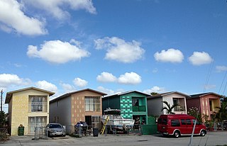
Brownsville is an unincorporated community and census-designated place (CDP) that is part of the Miami metropolitan area of South Florida. As of the 2020 US census, the population was 16,583, up from 15,313 in 2010. After three decades of population loss, Brownsville gained population for the first time in over 40 years in the 2010 US Census.

<span class="mw-page-title-main">Country Club, Florida</span> Census-designated place in Florida

Country Club is a census-designated place and a suburban unincorporated community located in northwest Miami-Dade County, Florida, United States. It is located in the Miami metropolitan area of South Florida. The CDP is named after the Country Club of Miami, which was established in 1961 in what was then an unpopulated and undeveloped section of the county. The population was 49,967 at the 2020 census, up from 3,408 in 1990.

<span class="mw-page-title-main">Fontainebleau, Florida</span> Census-designated place in Florida

Fontainebleau(incorrectly spelled "Fountainebleau" in the 2000 census) is a census-designated place (CDP) in Miami-Dade County, Florida, United States. It is part of the Miami metropolitan area of South Florida. The population was 59,870 during the 2020 census.

<span class="mw-page-title-main">Glenvar Heights, Florida</span> Census-designated place in Florida

Glenvar Heights is a census-designated place (CDP) and neighborhood in Miami-Dade County, Florida, United States. It is part of the Miami metropolitan area of South Florida. The population was 20,786 at the 2020 US census, up from 16,898 in 2010 US census.

<span class="mw-page-title-main">Hialeah, Florida</span> City in Florida

Hialeah is a city in Miami-Dade County, Florida, United States. With a population of 223,109 as of the 2020 census, Hialeah is the sixth-largest city in Florida. It is the second largest city by population in the Miami metropolitan area of South Florida, which was home to an estimated 6,198,782 people at the 2018 census. It is located west-northwest of Miami, and is one of a few places in the county—others being Homestead, Miami Beach, Surfside, Bal Harbour, Sunny Isles Beach, and Golden Beach—to have its own street grid numbered separately from the rest of the county.

<span class="mw-page-title-main">Ives Estates, Florida</span> Census-designated place in Florida

Ives Estates is a census-designated place (CDP) in Miami-Dade County, Florida. It is part of the Miami metropolitan area of South Florida. The population was 25,005 at the 2020 census, up from 19,525 in 2010.

<span class="mw-page-title-main">Kendall, Florida</span> Census-designated place in Florida

Kendall is an unincorporated area and census-designated place in Miami-Dade County, Florida. It is part of the Miami metropolitan area of South Florida. At the 2020 census, the area had a population of 80,241.

<span class="mw-page-title-main">Lake Lucerne, Florida</span> Neighborhood of Miami Gardens in Miami-Dade, Florida, United States

Lake Lucerne is a neighborhood in Miami Gardens, Florida. It is formerly a census-designated place. The population was 9,132 at the time of the 2000 United States census.

<span class="mw-page-title-main">Leisure City, Florida</span> Census-designated place in Florida

Leisure City is an unincorporated community and census-designated place (CDP) in Miami-Dade County, Florida, United States, that includes the smaller, older community of Modello in its northwestern section. The CDP is most notable for the Coral Castle Museum, located in the Modello area. It is located in the Miami metropolitan area of South Florida. The population was 26,324 at the 2020 census, up from 22,655 in 2010.

<span class="mw-page-title-main">Naranja, Florida</span> Census-designated place in Florida

Naranja is an unincorporated community and census-designated place (CDP) in Miami-Dade County, Florida, United States. Many orange groves were once located in this area, so the community name came from the Spanish word for orange, naranja, though the pronunciation among the local residents is "Na-Ran-Jah". Naranja was also a stop for the Florida East Coast Railroad that once ran through this area. It is part of the Miami metropolitan area of South Florida. The population was 13,509 at the 2020 census, up from 8,303 in 2010.

Norland, also known as Norwood, is a former census-designated place located in northern Miami-Dade County, Florida. The population was 22,995 at the 2000 census. The latest estimated population stands at 23,500. In 2003 the majority of this CDP was incorporated into the city of Miami Gardens, and it now serves as one of the city's neighborhoods.

<span class="mw-page-title-main">Opa-locka North, Florida</span> Neighborhood of Miami Gardens in Miami-Dade, Florida, United States

Opa-locka North is a neighborhood in Miami Gardens, Florida, United States. It was formerly a census-designated place. The population was 6,224 at the 2000 census.

<span class="mw-page-title-main">Pinewood, Florida</span> Census-designated place in Florida

Pinewood is an unincorporated community and census-designated place (CDP) in Miami-Dade County, Florida, United States. It is part of the Miami metropolitan area of South Florida. The population was 17,246 at the 2020 census.

<span class="mw-page-title-main">Scott Lake, Florida</span> Neighborhood of Miami Gardens in Miami-Dade, Florida, United States

Scott Lake is a neighborhood in Miami Gardens, Florida. It was formerly its own census-designated place. The population was 14,401 at the 2000 census.

<span class="mw-page-title-main">Tamiami, Florida</span> Census-designated place in Florida

Tamiami is a census-designated place (CDP) in Miami-Dade County, Florida, United States. It is part of the Miami metropolitan area of South Florida. The population was 54,212 at the 2020 census.

<span class="mw-page-title-main">The Crossings, Florida</span> CDP in Florida

The Crossings is a census-designated place (CDP) and suburb of Miami in Miami-Dade County, Florida, United States. It is part of the Miami metropolitan area of South Florida. The CDP includes the neighborhoods of The Crossings, Devon Aire, and Calusa. The population was 23,276 at the 2020 census.

<span class="mw-page-title-main">The Hammocks, Florida</span> Census-designated place in Florida

The Hammocks is a planned community and census-designated place in Miami-Dade County, Florida, United States. It is part of the Miami metropolitan area of South Florida. The population was 59,480 at the 2020 census, up from 51,003 in 2010.

<span class="mw-page-title-main">West Little River, Florida</span> CDP in Miami-Dade County, Florida, US

West Little River is a census-designated place (CDP) in Miami-Dade County, Florida, United States. It is part of the Miami metropolitan area of South Florida. The population was 34,128 at the 2020 census.

<span class="mw-page-title-main">Westchester, Florida</span> Census-designated place in Florida

Westchester is a census-designated place (CDP) and neighborhood in Miami-Dade County, Florida. It is part of the Miami metropolitan area of South Florida. Prior to the 2020 U.S. Census, the neighboring University Park CDP was merged into Westchester CDP, effectively doubling its geography and population. Per the 2020 census, the population was 56,384.

<span class="mw-page-title-main">Westview, Florida</span> Census-designated place in Florida

Westview is a census-designated place (CDP) in Miami-Dade County, Florida, United States. It is part of the Miami metropolitan area of South Florida. The population was 9,923 at the 2020 census.

References

  1. 1 2 "2022 U.S. Gazetteer Files: Florida". United States Census Bureau. Retrieved January 5, 2023.
  2. 1 2 "P1. Race – Gladeview CDP, Florida: 2020 DEC Redistricting Data (PL 94-171)". U.S. Census Bureau. Retrieved January 5, 2023.
  3. 1 2 "U.S. Census website". United States Census Bureau . Retrieved January 31, 2008.
  4. "US Board on Geographic Names". United States Geological Survey. October 25, 2007. Retrieved January 31, 2008.
  5. 1 2 "Original Miami, incorporated 1896, with subsequent annexations, dis-annexations & re-annexations". Digital Public Library of America . Retrieved August 14, 2023.
  6. "US Gazetteer files: 2010, 2000, and 1990". United States Census Bureau. February 12, 2011. Retrieved April 23, 2011.
  7. "Decennial Census of Population and Housing by Decades". US Census Bureau.
  8. "P2 HISPANIC OR LATINO, AND NOT HISPANIC OR LATINO BY RACE - 2010: DEC Redistricting Data (PL 94-171) - Gladeview CDP, Florida". United States Census Bureau . Retrieved January 19, 2022.
  9. "P2 HISPANIC OR LATINO, AND NOT HISPANIC OR LATINO BY RACE - 2020: DEC Redistricting Data (PL 94-171) - Gladeview CDP, Florida". United States Census Bureau . Retrieved January 19, 2022.
  10. "S1101 HOUSEHOLDS AND FAMILIES - 2020: Gladeview CDP, Florida". United States Census Bureau .
  11. "S1101 HOUSEHOLDS AND FAMILIES - 2010: Gladeview CDP, Florida". United States Census Bureau .
  12. "Demographics of Gladeview, FL". MuniNetGuide.com. Archived from the original on December 12, 2007. Retrieved November 6, 2007.
  13. "MLA Data Center Results of Gladeview, FL". Modern Language Association . Retrieved November 6, 2007.
  14. "Contact Corrections Archived 2012-10-09 at the Wayback Machine ." Miami-Dade County Corrections and Rehabilitation Department. Retrieved on September 16, 2012. "Headquarters 2525 NW 62nd Street Miami, Florida 33147"
  15. 1 2 "Gladeview CDP Archived 2011-06-06 at the Wayback Machine ." U.S. Census Bureau. Retrieved on May 15, 2010.
  16. "Stations & Units." Miami-Dade Fire Rescue. Retrieved on September 16, 2012.